44:
349:
339:. There were 63 households, comprising 87 males and 96 females, giving a sex ratio of 0.91 males per female. The median age was 44.2 years (compared with 37.4 years nationally), with 45 people (24.6%) aged under 15 years, 21 (11.5%) aged 15 to 29, 93 (50.8%) aged 30 to 64, and 27 (14.8%) aged 65 or older.
356:
Of those at least 15 years old, 18 (13.0%) people had a bachelor's or higher degree, and 27 (19.6%) people had no formal qualifications. The median income was $ 33,100, compared with $ 31,800 nationally. 21 people (15.2%) earned over $ 70,000 compared to 17.2% nationally. The employment status of
365:
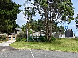
Waioneke School is a coeducational full primary (years 1-8) school with a roll of 94 students as of August 2024. The school traces its origins to
Mairetahi School, established in 1928. The school moved to its present site and took its current name in 1938.
725:
718:
711:
1098:
239:
A Waioneke Road Board was formed after 1884, and was responsible for forming and maintaining roads over much of the South Head peninsula. The board was dissolved by 1899.
1093:
342:
Ethnicities were 93.4% European/Pākehā, 11.5% Māori, 3.3% Pacific peoples, and 3.3% other ethnicities. People may identify with more than one ethnicity.
626:
345:
Although some people chose not to answer the census's question about religious affiliation, 63.9% had no religion and 27.9% were
Christian.
61:
489:
447:
417:
392:
587:
1088:
938:
357:
those at least 15 was that 81 (58.7%) people were employed full-time, 21 (15.2%) were part-time, and 3 (2.2%) were unemployed.
261:
182:
260:
Waioneke is in an SA1 statistical area which covers 18.15 km (7.01 sq mi). The SA1 area is part of the larger
993:
233:
975:
982:
969:
943:
640:
797:
735:
464:
437:
918:
661:
1032:
673:
336:
332:
328:
1066:
792:
228:
existed at
Waioneke prior to European settlement of the area. The Waioneke block was taken up in 1868 by
611:
998:
988:
43:
202:
147:
703:
210:
908:
1019:
832:
126:
933:
848:
868:
523:
485:
443:
433:
413:
388:
201:
is 22 km to the south-east, and the road continues another 14 km to the north-west.
1014:
928:
923:
913:
817:
170:
249:
Deer farming began in the area in the 1970s, and a processing plant was built in
Waioneke.
1049:
948:
893:
858:
206:
190:
186:
106:
222:
898:
878:
873:
853:
152:
1082:
888:
863:
229:
883:
1024:
903:
807:
772:
762:
743:
194:
116:
96:
348:
17:
964:
545:
243:
566:
76:
63:
812:
777:
739:
827:
802:
787:
782:
281:
198:
767:
757:
347:
225:
698:
252:
The
Kaipara Estate winery began in the Waioneke Valley in 1995.
707:
276:
327:
The SA1 statistical area had a population of 183 at the
1058:
1042:
1007:
957:
841:
750:
166:
161:
140:
132:
122:
112:
102:
92:
34:
213:and the southern Kaipara Harbour are to the east.
335:, and an increase of 81 people (79.4%) since the
236:) and William Spearman Young, to graze cattle.
629:. Statistics New Zealand. March 2020. 7001252.
621:
619:
719:
331:, an increase of 69 people (60.5%) since the
8:
627:"Statistical area 1 dataset for 2018 Census"
267:
1099:Populated places around the Kaipara Harbour
726:
712:
704:
266:
31:
1094:Populated places in the Auckland Region
375:
160:
139:
91:
56:
52:
40:
983:Helensville railway station (defunct)
612:2018 Census place summary: South Head
165:
131:
121:
111:
101:
29:Place in Auckland Region, New Zealand
7:
643:. New Zealand Ministry of Education
410:The Geographic Atlas of New Zealand
412:. Robbie Burton. pp. map 34.
167: • Territorial Authority
25:
1033:Rodney District Council (defunct)
976:Kumeu–Riverhead Section (defunct)
662:Education Counts: Waioneke School
42:
939:Te Korowai-o-Te-Tonga Peninsula
641:"New Zealand Schools Directory"
408:Roger Smith, GeographX (2005).
387:. Reed Books. pp. map 11.
183:Te Korowai-o-Te-Tonga Peninsula
482:Tall Spars, Steamers & Gum
463:Sheffield, Colleen M. (1963).
1:
526:. Helensville Pioneer Museum
994:Te Rau Pūriri Regional Park
439:The Prehistory of Polynesia
383:Peter Dowling, ed. (2004).
262:South Head statistical area
1115:
970:Goldie Bush Scenic Reserve
958:Facilities and attractions
546:"Kaipara Estate - History"
674:"Waioneke School History"
567:"Kaipara Estate - People"
320:
294:—
242:Waioneke was a centre of
57:
53:
41:
588:"ArcGIS Web Application"
1089:Rodney Local Board Area
944:Upper Waitematā Harbour
699:Waioneke School website
592:statsnz.maps.arcgis.com
329:2018 New Zealand census
1067:Veronica jovellanoides
480:Ryburn, Wayne (1999).
385:Reed New Zealand Atlas
353:
234:Premier of New Zealand
77:36.54167°S 174.30139°E
999:West Auckland Airport
989:Muriwai Regional Park
434:Jennings, Jesse David
351:
268:Historical population
209:are to the west, and
181:is a locality on the
734:Kumeū Subdivision –
148:Kaipara ki Mahurangi
82:-36.54167; 174.30139
842:Geographic features
269:
246:from 1880 to 1900.
73: /
1020:Rodney Local Board
919:Ōpāhekeheke Island
354:
232:(who later became
127:Rodney Local Board
1076:
1075:
869:Kaukapakapa River
676:. Waioneke School
466:Men Came Voyaging
325:
324:
176:
175:
136:Kumeū subdivision
16:(Redirected from
1106:
1059:Related articles
1015:Auckland Council
929:Riverhead Forest
924:Ourauwhare River
909:Ōkiritoto Stream
818:Waikoukou Valley
751:Populated places
728:
721:
714:
705:
686:
685:
683:
681:
670:
664:
659:
653:
652:
650:
648:
637:
631:
630:
623:
614:
609:
603:
602:
600:
598:
584:
578:
577:
575:
573:
563:
557:
556:
554:
552:
542:
536:
535:
533:
531:
520:
514:
511:
505:
502:
496:
495:
477:
471:
470:
460:
454:
453:
430:
424:
423:
405:
399:
398:
380:
283:
278:
270:
171:Auckland Council
88:
87:
85:
84:
83:
78:
74:
71:
70:
69:
66:
46:
32:
21:
1114:
1113:
1109:
1108:
1107:
1105:
1104:
1103:
1079:
1078:
1077:
1072:
1054:
1050:Kaipara College
1038:
1003:
953:
949:Woodhill Forest
934:Tāhekeroa River
894:Moturemu Island
859:Kaipara Harbour
849:Arapārera River
837:
746:
732:
695:
690:
689:
679:
677:
672:
671:
667:
660:
656:
646:
644:
639:
638:
634:
625:
624:
617:
610:
606:
596:
594:
586:
585:
581:
571:
569:
565:
564:
560:
550:
548:
544:
543:
539:
529:
527:
522:
521:
517:
512:
508:
503:
499:
492:
479:
478:
474:
462:
461:
457:
450:
442:. p. 244.
432:
431:
427:
420:
407:
406:
402:
395:
382:
381:
377:
372:
363:
352:Waioneke School
258:
219:
207:Woodhill Forest
203:Rangitira Beach
191:Rodney District
187:Kaipara Harbour
157:
123:Community board
107:Auckland Region
81:
79:
75:
72:
67:
64:
62:
60:
59:
49:
48:Waioneke School
37:
30:
23:
22:
18:Waioneke School
15:
12:
11:
5:
1112:
1110:
1102:
1101:
1096:
1091:
1081:
1080:
1074:
1073:
1071:
1070:
1062:
1060:
1056:
1055:
1053:
1052:
1046:
1044:
1040:
1039:
1037:
1036:
1029:
1028:
1027:
1022:
1011:
1009:
1005:
1004:
1002:
1001:
996:
991:
986:
979:
972:
967:
961:
959:
955:
954:
952:
951:
946:
941:
936:
931:
926:
921:
916:
911:
906:
901:
899:Mount Auckland
896:
891:
886:
881:
879:Lake Kuwakatai
876:
871:
866:
861:
856:
851:
845:
843:
839:
838:
836:
835:
830:
825:
820:
815:
810:
805:
800:
795:
790:
785:
780:
775:
770:
765:
760:
754:
752:
748:
747:
733:
731:
730:
723:
716:
708:
702:
701:
694:
693:External links
691:
688:
687:
665:
654:
632:
615:
604:
579:
558:
537:
515:
506:
497:
490:
484:. p. 21.
472:
455:
448:
425:
418:
400:
393:
374:
373:
371:
368:
362:
359:
323:
322:
318:
317:
314:
311:
307:
306:
303:
300:
296:
295:
292:
289:
285:
284:
279:
274:
257:
254:
218:
215:
211:Omokoiti Flats
174:
173:
168:
164:
163:
159:
158:
156:
155:
153:Te Tai Tokerau
150:
144:
142:
138:
137:
134:
130:
129:
124:
120:
119:
114:
110:
109:
104:
100:
99:
94:
90:
89:
55:
54:
51:
50:
47:
39:
38:
35:
28:
24:
14:
13:
10:
9:
6:
4:
3:
2:
1111:
1100:
1097:
1095:
1092:
1090:
1087:
1086:
1084:
1069:
1068:
1064:
1063:
1061:
1057:
1051:
1048:
1047:
1045:
1043:Organisations
1041:
1035:
1034:
1030:
1026:
1023:
1021:
1018:
1017:
1016:
1013:
1012:
1010:
1006:
1000:
997:
995:
992:
990:
987:
985:
984:
980:
978:
977:
973:
971:
968:
966:
963:
962:
960:
956:
950:
947:
945:
942:
940:
937:
935:
932:
930:
927:
925:
922:
920:
917:
915:
914:Ōmaumau River
912:
910:
907:
905:
902:
900:
897:
895:
892:
890:
889:Makarau River
887:
885:
882:
880:
877:
875:
872:
870:
867:
865:
864:Kaipara River
862:
860:
857:
855:
852:
850:
847:
846:
844:
840:
834:
831:
829:
826:
824:
821:
819:
816:
814:
811:
809:
806:
804:
801:
799:
796:
794:
791:
789:
786:
784:
781:
779:
776:
774:
771:
769:
766:
764:
761:
759:
756:
755:
753:
749:
745:
741:
737:
729:
724:
722:
717:
715:
710:
709:
706:
700:
697:
696:
692:
675:
669:
666:
663:
658:
655:
642:
636:
633:
628:
622:
620:
616:
613:
608:
605:
593:
589:
583:
580:
568:
562:
559:
547:
541:
538:
525:
519:
516:
513:Ryburn, p 132
510:
507:
501:
498:
493:
491:0-473-06176-7
487:
483:
476:
473:
469:. p. 78.
468:
467:
459:
456:
451:
449:0-674-70060-0
445:
441:
440:
435:
429:
426:
421:
419:1-877333-20-4
415:
411:
404:
401:
396:
394:0-7900-0952-8
390:
386:
379:
376:
369:
367:
360:
358:
350:
346:
343:
340:
338:
334:
330:
319:
315:
312:
309:
308:
304:
301:
298:
297:
293:
290:
287:
286:
280:
275:
272:
271:
265:
263:
255:
253:
250:
247:
245:
240:
237:
235:
231:
230:Daniel Pollen
227:
224:
216:
214:
212:
208:
204:
200:
196:
192:
188:
184:
180:
172:
169:
154:
151:
149:
146:
145:
143:
135:
128:
125:
118:
115:
108:
105:
98:
95:
86:
58:Coordinates:
45:
33:
27:
19:
1065:
1031:
981:
974:
884:Lake Rototoa
822:
798:Shelly Beach
678:. Retrieved
668:
657:
647:17 September
645:. Retrieved
635:
607:
595:. Retrieved
591:
582:
570:. Retrieved
561:
549:. Retrieved
540:
528:. Retrieved
524:"South Head"
518:
509:
504:Ryburn, p 89
500:
481:
475:
465:
458:
438:
428:
409:
403:
384:
378:
364:
355:
344:
341:
326:
259:
256:Demographics
251:
248:
241:
238:
220:
178:
177:
26:
1025:Rodney ward
904:Oaia Island
874:Kumeū River
854:Hōteo River
808:Waipatukahu
773:Kaukapakapa
763:Helensville
744:New Zealand
337:2006 census
333:2013 census
244:gum digging
195:New Zealand
141:Electorates
133:Subdivision
117:Rodney Ward
97:New Zealand
80: /
68:174°18′05″E
1083:Categories
1008:Government
965:Gibbs Farm
572:10 October
551:10 October
530:10 October
162:Government
65:36°32′30″S
793:Riverhead
680:7 October
361:Education
189:, in the
833:Woodhill
823:Waioneke
813:Waimauku
740:Auckland
436:(1979).
321:Source:
179:Waioneke
36:Waioneke
828:Waitoki
803:Taupaki
788:Parakai
783:Muriwai
282:±% p.a.
217:History
199:Parakai
185:of the
93:Country
768:Huapai
758:Glorit
736:Rodney
597:15 May
488:
446:
416:
391:
316:+9.93%
305:+1.60%
103:Region
778:Kumeū
370:Notes
223:Māori
682:2008
649:2024
599:2022
574:2008
553:2008
532:2008
486:ISBN
444:ISBN
414:ISBN
389:ISBN
310:2018
299:2013
288:2006
277:Pop.
273:Year
205:and
113:Ward
313:183
302:114
291:102
193:of
1085::
742:,
738:,
618:^
590:.
264:.
226:pā
221:A
197:.
727:e
720:t
713:v
684:.
651:.
601:.
576:.
555:.
534:.
494:.
452:.
422:.
397:.
20:)
Text is available under the Creative Commons Attribution-ShareAlike License. Additional terms may apply.