45:
29:
304:, several miles to the north. Before damming, Walnut Creek was one of the only reliable streams in this arid region, flowing consistently each spring with the melting of snowpack on the Colorado Plateau. After the Upper Lake Mary Dam was constructed in 1941, Walnut Creek dried up below the Lower Lake Mary Dam due to increased water diversions. Since then, the creek has flowed only during monsoon rains or exceptionally heavy snowmelt.
52:
307:
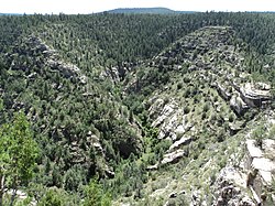
The creek makes a sharp turn to the east at Fisher Point and carves the narrow, winding Walnut Canyon, a limestone gorge up to 600 feet (180 m) deep. About 10 miles (16 km) east of
Flagstaff it passes through
332:, forming San Francisco Wash. San Francisco Wash continues east, eventually discharging into Padre Canyon Wash, in turn flowing into Diablo Wash which joins the Little Colorado River near
336:. The San Francisco Wash is sometimes considered the lower part of Walnut Creek, and the total length of the stream would be 55 miles (89 km) if this is included.
532:
44:
350:
389:
207:
380:
131:
505:
385:
309:
537:
345:
293:
117:
375:
270:
296:. It flows northwest along the south side of Anderson Mesa where it is impounded in two reservoirs,
297:
28:
301:
277:
436:
105:
478:
415:
321:
281:
262:
193:
276:. The creek flows about 34 miles (55 km) in a northeasterly direction from south of
333:
313:
273:
526:
325:
76:
457:
320:
people between 1100 and 1250 A.D. Near the end of the canyon the creek approaches
329:
177:
222:
209:
146:
133:
317:
266:
86:
292:
Walnut Creek begins in a small valley near Mormon
Mountain, in the
479:"Walnut Canyon National Monument History & Culture - People"
499:
300:, which were dammed in the early 1900s to supply water to
248:
238:
199:
186:
176:
162:
123:
111:
101:
92:
82:
72:
67:
21:
328:, before flowing north to its confluence with the
59:Location of the mouth of Walnut Creek in Arizona
51:
8:
410:
408:
406:
351:List of tributaries of the Colorado River
390:United States Department of the Interior
362:
370:
368:
366:
18:
437:"History of Flagstaff's Water System"
7:
381:Geographic Names Information System
533:Rivers of Coconino County, Arizona
16:Stream in Coconino County, Arizona
14:
418:. United States Geological Survey
501:USGS Topo Maps for United States
50:
43:
27:
506:United States Geological Survey
386:United States Geological Survey
310:Walnut Canyon National Monument
416:"USGS National Atlas Streamer"
201: • coordinates
125: • coordinates
1:
93:Physical characteristics
481:. U.S. National Park Service
460:. U.S. National Park Service
244:6,184 ft (1,885 m)
240: • elevation
168:7,320 ft (2,230 m)
164: • elevation
188: • location
113: • location
554:
346:List of rivers of Arizona
298:Upper and Lower Lake Mary
172:
97:
38:
26:
294:Coconino National Forest
118:Coconino National Forest
252:34 mi (55 km)
504:(Map). Cartography by
223:35.24472°N 111.42000°W
147:34.98861°N 111.47194°W
271:Little Colorado River
261:is a major stream in
458:"Rivers and Streams"
269:that is part of the
228:35.24472; -111.42000
152:34.98861; -111.47194
439:. City of Flagstaff
316:constructed by the
219: /
143: /
324:and crosses under
182:San Francisco Wash
538:Rivers of Arizona
256:
255:
545:
517:
516:
514:
513:
496:
490:
489:
487:
486:
475:
469:
468:
466:
465:
454:
448:
447:
445:
444:
433:
427:
426:
424:
423:
412:
401:
400:
398:
397:
372:
312:, known for its
234:
233:
231:
230:
229:
224:
220:
217:
216:
215:
212:
165:
158:
157:
155:
154:
153:
148:
144:
141:
140:
139:
136:
126:
114:
106:Colorado Plateau
54:
53:
47:
31:
19:
553:
552:
548:
547:
546:
544:
543:
542:
523:
522:
521:
520:
511:
509:
498:
497:
493:
484:
482:
477:
476:
472:
463:
461:
456:
455:
451:
442:
440:
435:
434:
430:
421:
419:
414:
413:
404:
395:
393:
374:
373:
364:
359:
342:
314:cliff dwellings
290:
263:Coconino County
241:
227:
225:
221:
218:
213:
210:
208:
206:
205:
202:
189:
163:
151:
149:
145:
142:
137:
134:
132:
130:
129:
124:
112:
63:
62:
61:
60:
57:
56:
55:
34:
17:
12:
11:
5:
551:
549:
541:
540:
535:
525:
524:
519:
518:
491:
470:
449:
428:
402:
376:"Walnut Creek"
361:
360:
358:
355:
354:
353:
348:
341:
338:
334:Leupp, Arizona
289:
286:
274:drainage basin
254:
253:
250:
246:
245:
242:
239:
236:
235:
203:
200:
197:
196:
190:
187:
184:
183:
180:
174:
173:
170:
169:
166:
160:
159:
127:
121:
120:
115:
109:
108:
103:
99:
98:
95:
94:
90:
89:
84:
80:
79:
74:
70:
69:
65:
64:
58:
49:
48:
42:
41:
40:
39:
36:
35:
32:
24:
23:
15:
13:
10:
9:
6:
4:
3:
2:
550:
539:
536:
534:
531:
530:
528:
508:. ACME Mapper
507:
503:
502:
495:
492:
480:
474:
471:
459:
453:
450:
438:
432:
429:
417:
411:
409:
407:
403:
391:
387:
383:
382:
377:
371:
369:
367:
363:
356:
352:
349:
347:
344:
343:
339:
337:
335:
331:
327:
326:Interstate 40
323:
319:
315:
311:
305:
303:
299:
295:
287:
285:
283:
279:
275:
272:
268:
264:
260:
251:
247:
243:
237:
232:
204:
198:
195:
191:
185:
181:
179:
175:
171:
167:
161:
156:
128:
122:
119:
116:
110:
107:
104:
100:
96:
91:
88:
85:
81:
78:
77:United States
75:
71:
66:
46:
37:
33:Walnut Canyon
30:
25:
20:
510:. Retrieved
500:
494:
483:. Retrieved
473:
462:. Retrieved
452:
441:. Retrieved
431:
420:. Retrieved
394:. Retrieved
392:. 1980-02-08
379:
306:
291:
259:Walnut Creek
258:
257:
22:Walnut Creek
330:Rio de Flag
226: /
214:111°25′12″W
150: /
138:111°28′19″W
527:Categories
512:2017-05-01
485:2017-05-01
464:2017-05-01
443:2017-05-01
422:2017-05-01
396:2017-05-01
357:References
211:35°14′41″N
135:34°59′19″N
302:Flagstaff
288:Geography
278:Flagstaff
340:See also
280:to near
68:Location
318:Sinagua
267:Arizona
87:Arizona
73:Country
322:Winona
282:Winona
249:Length
194:Winona
102:Source
192:Near
178:Mouth
83:State
529::
405:^
388:,
384:.
378:.
365:^
284:.
265:,
515:.
488:.
467:.
446:.
425:.
399:.
Text is available under the Creative Commons Attribution-ShareAlike License. Additional terms may apply.