63:
75:
995:
51:
175:
714:
In the township the population was spread out, with 27.1% under the age of 18, 8.1% from 18 to 24, 29.0% from 25 to 44, 23.0% from 45 to 64, and 12.8% who were 65 years of age or older. The median age was 36 years. For every 100 females there were 102.0 males. For every 100 females age 18 and over,
674:
of 2000, there were 2,598 people, 920 households, and 734 families residing in the township. The population density was 89.5 inhabitants per square mile (34.6/km). There were 997 housing units at an average density of 34.4 per square mile (13.3/km). The racial makeup of the township was 98.85%
710:
living together, 5.1% had a female householder with no husband present, and 20.2% were non-families. 16.8% of all households were made up of individuals, and 9.2% had someone living alone who was 65 years of age or older. The average household size was 2.82 and the average family size was 3.18.
729:
Walker
Township was unfortunately the municipality in which a lone gunman took on the state and local law enforcement on July 8 ,2023, critically wounding one Pennsylvania State Police Lieutenant and killing a State Trooper. The gunman was killed in a shootout that day with law enforcement.
62:
1208:
718:
The median income for a household in the township was $ 37,639, and the median income for a family was $ 41,351. Males had a median income of $ 27,047 versus $ 22,070 for females. The
300:, the township has a total area of 29.35 square miles (76.02 km), of which 28.83 square miles (74.66 km) are land and 0.52 square miles (1.35 km), or 1.78%, are water.
918:
1252:
1058:
1068:
1033:
1028:
304:
1018:
312:
74:
1043:
332:
17:
1247:
1048:
1257:
1038:
825:
911:
248:
50:
904:
1106:
340:
1053:
347:
in Walker
Township. Other unincorporated places in the township include Vandyke, Centre, Locust Run, Mount Pleasant, and Van Wert.
749:
107:
896:
779:
1063:
1023:
680:
320:
308:
684:
1101:
1091:
1013:
928:
281:
112:
1185:
1157:
881:
833:
692:
297:
984:
316:
207:
1142:
974:
950:
636:
621:
606:
591:
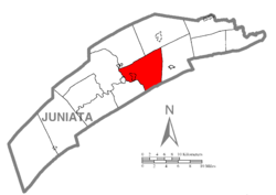
576:
561:
546:
531:
516:
501:
486:
471:
456:
441:
426:
411:
396:
381:
1137:
1122:
1096:
979:
328:
236:
85:
1132:
1111:
1083:
1005:
706:
There were 920 households, out of which 35.8% had children under the age of 18 living with them, 71.2% were
336:
277:
41:
1162:
961:
826:"Geographic Identifiers: 2010 Census Summary File 1 (G001): Walker township, Juniata County, Pennsylvania"
696:
324:
969:
228:
1192:
700:
217:
688:
676:
1152:
1147:
722:
for the township was $ 16,118. About 6.4% of families and 9.6% of the population were below the
855:
799:
719:
811:
1241:
344:
241:
723:
285:
100:
943:
95:
1223:
1210:
198:
1176:‡This populated place also has portions in an adjacent county or counties.
726:, including 12.8% of those under age 18 and 6.3% of those age 65 or over.
707:
671:
224:
203:
303:
Walker
Township is in central Juniata County and is bordered by
67:
Map of
Juniata County, Pennsylvania highlighting Walker Township
900:
288:, United States. The population was 2,797 at the 2020 census.
993:
262:
877:
16:
773:
771:
769:
767:
1171:
1121:
1082:
1004:
960:
257:
247:
235:
214:
197:
189:
181:
168:
163:
155:
147:
139:
134:
126:
118:
106:
94:
84:
28:
912:
335:form the western border of the township. The
8:
780:"City and Town Population Totals: 2020-2022"
919:
905:
897:
703:of any race were 0.58% of the population.
354:
25:
1253:Townships in Juniata County, Pennsylvania
741:
256:
246:
234:
196:
162:
133:
117:
83:
59:
47:
23:Township in Pennsylvania, United States
807:
797:
374:
213:
188:
180:
167:
154:
151:28.83 sq mi (74.66 km)
146:
143:29.35 sq mi (76.02 km)
138:
125:
105:
93:
71:
7:
1248:Populated places established in 1765
832:. U.S. Census Bureau. Archived from
695:, and 0.19% from two or more races.
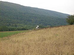
55:Farm and mountain in Walker Township
1258:1765 establishments in Pennsylvania
159:0.52 sq mi (1.35 km)
79:Map of Juniata County, Pennsylvania
927:Municipalities and communities of
856:"Census of Population and Housing"
364:
14:
174:
173:
73:
61:
49:
1:
752:. United States Census Bureau
18:Walker Township, Pennsylvania
930:Juniata County, Pennsylvania
882:United States Census Bureau
750:"2016 U.S. Gazetteer Files"
323:to the west and south. The
298:United States Census Bureau
193:95.88/sq mi (37.02/km)
182: • Estimate
1274:
15:
1181:
991:
941:
663:
650:
635:
620:
605:
590:
575:
560:
545:
530:
515:
500:
485:
470:
455:
440:
425:
410:
395:
380:
373:
368:
363:
360:
72:
60:
48:
39:
715:there were 97.3 males.
337:census-designated place
998:
1224:40.55000°N 77.37639°W
997:
878:"U.S. Census website"
664:U.S. Decennial Census
356:Historical population
216: • Summer (
1194:United States portal
836:on February 13, 2020
190: • Density
1229:40.55000; -77.37639
1220: /
1187:Pennsylvania portal
830:American Factfinder
778:Bureau, US Census.
357:
999:
810:has generic name (
786:. US Census Bureau
355:
319:to the south, and
169: • Total
156: • Water
140: • Total
1203:
1202:
720:per capita income
668:
667:
313:Delaware Township
309:Fayette Townships
296:According to the
271:
270:
148: • Land
1265:
1235:
1234:
1232:
1231:
1230:
1225:
1221:
1218:
1217:
1216:
1213:
1195:
1188:
996:
953:
946:
936:
931:
921:
914:
907:
898:
892:
891:
889:
888:
874:
868:
867:
865:
863:
852:
846:
845:
843:
841:
822:
816:
815:
809:
805:
803:
795:
793:
791:
775:
762:
761:
759:
757:
746:
681:African American
376:
371:
366:
358:
333:Milford Township
321:Turbett Township
267:
264:
221:
177:
176:
77:
65:
53:
30:Walker Township,
26:
1273:
1272:
1268:
1267:
1266:
1264:
1263:
1262:
1238:
1237:
1228:
1226:
1222:
1219:
1214:
1211:
1209:
1207:
1206:
1204:
1199:
1193:
1186:
1177:
1167:
1124:
1117:
1078:
1000:
994:
989:
956:
951:
944:
937:
934:
929:
925:
895:
886:
884:
876:
875:
871:
861:
859:
854:
853:
849:
839:
837:
824:
823:
819:
806:
796:
789:
787:
777:
776:
765:
755:
753:
748:
747:
743:
739:
733:
708:married couples
685:Native American
369:
353:
294:
274:Walker Township
261:
215:
80:
68:
56:
44:
35:
33:
32:Juniata County,
31:
24:
21:
12:
11:
5:
1271:
1269:
1261:
1260:
1255:
1250:
1240:
1239:
1201:
1200:
1198:
1197:
1190:
1182:
1179:
1178:
1175:
1173:
1169:
1168:
1166:
1165:
1160:
1155:
1150:
1145:
1140:
1135:
1129:
1127:
1123:Unincorporated
1119:
1118:
1116:
1115:
1109:
1104:
1102:McAlisterville
1099:
1094:
1092:East Waterford
1088:
1086:
1080:
1079:
1077:
1076:
1071:
1066:
1061:
1056:
1051:
1046:
1041:
1036:
1031:
1026:
1021:
1016:
1010:
1008:
1002:
1001:
992:
990:
988:
987:
982:
977:
972:
966:
964:
958:
957:
942:
939:
938:
926:
924:
923:
916:
909:
901:
894:
893:
869:
847:
817:
763:
740:
738:
735:
666:
665:
661:
660:
657:
655:
652:
648:
647:
644:
642:
639:
633:
632:
629:
627:
624:
618:
617:
614:
612:
609:
603:
602:
599:
597:
594:
588:
587:
584:
582:
579:
573:
572:
569:
567:
564:
558:
557:
554:
552:
549:
543:
542:
539:
537:
534:
528:
527:
524:
522:
519:
513:
512:
509:
507:
504:
498:
497:
494:
492:
489:
483:
482:
479:
477:
474:
468:
467:
464:
462:
459:
453:
452:
449:
447:
444:
438:
437:
434:
432:
429:
423:
422:
419:
417:
414:
408:
407:
404:
402:
399:
393:
392:
389:
387:
384:
378:
377:
372:
367:
362:
352:
349:
311:to the north,
293:
290:
282:Juniata County
269:
268:
263:walkertownship
259:
255:
254:
251:
245:
244:
239:
233:
232:
222:
212:
211:
201:
195:
194:
191:
187:
186:
183:
179:
178:
170:
166:
165:
161:
160:
157:
153:
152:
149:
145:
144:
141:
137:
136:
132:
131:
128:
124:
123:
120:
116:
115:
110:
104:
103:
98:
92:
91:
88:
82:
81:
78:
70:
69:
66:
58:
57:
54:
46:
45:
40:
37:
36:
29:
22:
13:
10:
9:
6:
4:
3:
2:
1270:
1259:
1256:
1254:
1251:
1249:
1246:
1245:
1243:
1236:
1233:
1196:
1191:
1189:
1184:
1183:
1180:
1174:
1170:
1164:
1161:
1159:
1158:Oakland Mills
1156:
1154:
1151:
1149:
1146:
1144:
1141:
1139:
1136:
1134:
1131:
1130:
1128:
1126:
1120:
1113:
1110:
1108:
1105:
1103:
1100:
1098:
1095:
1093:
1090:
1089:
1087:
1085:
1081:
1075:
1072:
1070:
1067:
1065:
1062:
1060:
1057:
1055:
1052:
1050:
1047:
1045:
1042:
1040:
1037:
1035:
1032:
1030:
1027:
1025:
1022:
1020:
1017:
1015:
1012:
1011:
1009:
1007:
1003:
986:
983:
981:
978:
976:
973:
971:
968:
967:
965:
963:
959:
955:
954:
947:
940:
935:United States
932:
922:
917:
915:
910:
908:
903:
902:
899:
883:
879:
873:
870:
857:
851:
848:
835:
831:
827:
821:
818:
813:
801:
785:
781:
774:
772:
770:
768:
764:
751:
745:
742:
736:
734:
731:
727:
725:
721:
716:
712:
709:
704:
702:
698:
694:
691:, 0.23% from
690:
686:
682:
678:
673:
662:
658:
656:
653:
649:
645:
643:
640:
638:
634:
630:
628:
625:
623:
619:
615:
613:
610:
608:
604:
600:
598:
595:
593:
589:
585:
583:
580:
578:
574:
570:
568:
565:
563:
559:
555:
553:
550:
548:
544:
540:
538:
535:
533:
529:
525:
523:
520:
518:
514:
510:
508:
505:
503:
499:
495:
493:
490:
488:
484:
480:
478:
475:
473:
469:
465:
463:
460:
458:
454:
450:
448:
445:
443:
439:
435:
433:
430:
428:
424:
420:
418:
415:
413:
409:
405:
403:
400:
398:
394:
390:
388:
385:
383:
379:
359:
350:
348:
346:
345:Juniata River
343:is along the
342:
338:
334:
330:
326:
322:
318:
315:to the east,
314:
310:
306:
301:
299:
291:
289:
287:
283:
279:
275:
266:
260:
252:
250:
243:
240:
238:
230:
226:
223:
219:
209:
205:
202:
200:
192:
184:
171:
158:
150:
142:
129:
121:
114:
111:
109:
102:
99:
97:
90:United States
89:
87:
76:
64:
52:
43:
38:
27:
19:
1205:
1073:
985:Thompsontown
949:
885:. Retrieved
872:
860:. Retrieved
858:. Census.gov
850:
840:November 26,
838:. Retrieved
834:the original
829:
820:
808:|last1=
788:. Retrieved
783:
754:. Retrieved
744:
732:
728:
724:poverty line
717:
713:
705:
669:
351:Demographics
317:Perry County
302:
295:
286:Pennsylvania
273:
272:
253:42-067-80568
127:Incorporated
101:Pennsylvania
34:Pennsylvania
1227: /
1143:Honey Grove
1125:communities
1059:Susquehanna
1054:Spruce Hill
975:Mifflintown
952:Mifflintown
945:County seat
790:January 31,
693:other races
651:2022 (est.)
1242:Categories
1215:77°22′35″W
1212:40°33′00″N
1138:Cuba Mills
1097:East Salem
980:Port Royal
887:2008-01-31
784:Census.gov
737:References
670:As of the
329:Port Royal
164:Population
1172:Footnotes
1133:Cocolamus
1112:Richfield
1069:Tuscarora
1034:Greenwood
1029:Fermanagh
1006:Townships
305:Fermanagh
292:Geography
249:FIPS code
237:Area code
199:Time zone
1163:Oriental
1019:Delaware
962:Boroughs
800:cite web
697:Hispanic
687:, 0.19%
683:, 0.04%
679:, 0.50%
278:township
42:Township
1064:Turbett
1044:Milford
1024:Fayette
970:Mifflin
862:June 4,
756:Aug 14,
325:borough
258:Website
119:Settled
113:Juniata
86:Country
1107:Mexico
1074:Walker
1049:Monroe
701:Latino
672:census
451:−12.3%
361:Census
341:Mexico
172:2,797
108:County
1014:Beale
689:Asian
677:White
659:−0.1%
654:2,793
641:2,797
626:2,738
616:11.5%
611:2,598
596:2,331
586:20.2%
581:2,124
566:1,767
551:1,755
541:−3.6%
536:1,620
526:10.3%
521:1,681
511:12.7%
506:1,524
496:−4.6%
491:1,352
476:1,417
466:−6.6%
461:1,392
446:1,490
431:1,699
421:−6.5%
416:1,608
406:15.1%
401:1,719
386:1,493
276:is a
225:UTC-4
204:UTC-5
185:2,793
96:State
1153:Nook
1148:Maze
1084:CDPs
1039:Lack
864:2016
842:2018
812:help
792:2024
758:2017
646:2.2%
637:2020
631:5.4%
622:2010
607:2000
601:9.7%
592:1990
577:1980
571:0.7%
562:1970
556:8.3%
547:1960
532:1950
517:1940
502:1930
487:1920
481:1.8%
472:1910
457:1900
442:1890
436:5.7%
427:1880
412:1870
397:1860
382:1850
370:Note
365:Pop.
331:and
307:and
265:.org
135:Area
130:1822
122:1765
699:or
339:of
327:of
280:in
242:717
229:EDT
218:DST
208:EST
1244::
948::
933:,
880:.
828:.
804::
802:}}
798:{{
782:.
766:^
375:%±
284:,
1114:‡
920:e
913:t
906:v
890:.
866:.
844:.
814:)
794:.
760:.
391:—
231:)
227:(
220:)
210:)
206:(
20:.
Text is available under the Creative Commons Attribution-ShareAlike License. Additional terms may apply.