416:
482:
47:
54:
31:
232:
540:
Development of Wall since the Romans has been slow, and it has never developed beyond a small village. The earliest medieval settlement may have been on the higher ground. Wall House on Green Lane, although dating from the 18th century, is probably on the site of the medieval manor house. Wall Hall
630:
Black brook runs below the gravel terrace west of Wall. Crane brook runs through Hilton and
Chesterfield and is the source for Hilton's main street name of 'Cranebrook Lane'. A spring south of Pipe Grange feeds a stream which flows east to Leamonsley Brook. A spring rising in Aldershawe was used
617:
The north of the parish including
Pipehill, Aldershawe and east parts of Wall are underlain with Bromsgrove Sandstone. The south of the parish including west Wall, Hilton and Chesterfield are underlain by Wildmoor Sandstone. A narrow gravel terrace runs north west from Wall to a point south of
660:
500:
In the late 3rd or early 4th century the eastern part of the settlement of approximately 6 acres (2.4 ha), between the present Wall Lane and Green Lane and straddling
Watling Street, was enclosed with a stone wall surrounded by an earth
505:
and ditches. Civilians continued to live inside the settlement and on its outskirts in the late 4th century. The settlement appears to have declined rapidly soon after the Romans left
Britain in AD 410 and the focus of settlement shifted to
541:
to the south also dates from the mid 18th century but replaced a house which existed in the 17th century. By the late 18th century several dwellings were built on
Watling Street west of Manor Farm and formed the lower part of the village.
492:
In the 2nd century the settlement covered approximately 30 acres (12 ha) west of the later Wall Lane. By the 1st or 2nd century there was a burial area beyond the western end of the settlement. The settlement was mentioned in the
600:
The upper part of Wall village lies at an elevation of 114 m on the edge of a plateau; the lower part to the south of
Watling Street lies 16 m lower. At Aldershawe the land lies at 130 m, and it is the same level at
477:
was built on the lower ground south west of the fort in the late 1st century for use by its soldiers. It was later used by the inhabitants of a civilian settlement which grew up around
Watling Street.
631:
for centuries as the source for drinking water for the city of
Lichfield. Conduits were dug from Aldershawe to Lichfield where they supplied water from various conduits around the city.
272:
136:
256:
93:
904:
702:
1101:
640:
415:
218:
316:
740:
280:
249:
46:
244:
1096:
852:
827:
897:
847:
298:
545:
308:
261:
206:
172:
583:
The
Trooper Inn existed by 1851. In the 1950s ten council houses were built on a road called The Butts. The re-routing of the
770:
438:
period found in the upper part of Wall village. The first detailed evidence of human settlement comes in the 1st century. A
86:
815:
481:
1091:
890:
1065:
380:
303:
1035:
553:
186:
953:
932:
584:
397:
1045:
1025:
619:
162:
465:
A fort was certainly built in the upper area of the village near to the present church in 50s or 60s and
948:
572:
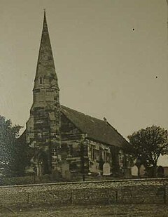
and a west door; it is square at the base, rises to become octagonal, and is surmounted by a spire with
1070:
1009:
973:
577:
549:
237:
126:
118:
794:
1050:
913:
528:
494:
154:
943:
823:
736:
523:
999:
843:
807:
455:
447:
211:
1030:
958:
762:
606:
587:
around Wall in 1965 relieved the village of traffic, re-establishing its quiet nature.
502:
470:
466:
1085:
1014:
819:
434:
The earliest evidence of settlement in Wall is the discovery of flints dating to the
365:
357:
144:
67:
353:
102:
454:
or "Greywood") was established at Wall in or soon after AD 50 to accommodate
781:
510:. Despite this shift of population, David Ford identifies the community as the
994:
984:
439:
331:
318:
1040:
1019:
1004:
937:
507:
485:
435:
429:
369:
361:
196:
963:
602:
569:
404:
376:
30:
1060:
989:
978:
927:
877:
754:
573:
565:
561:
519:
401:
178:
968:
882:
618:
Pipehill where it merges into an area of
Boulder Clay. South of Wall
474:
383:
and Chesterfield, and the tiny hamlet of Aldershawe, which is about
480:
459:
414:
544:
In 1839 the church was built, and in 1843 was consecrated as the
557:
515:
886:
681:
733:
A History of the County of Stafford: Volume XIV: Lichfield
622:
overlie the area including, Hilton and Chesterfield.
568:. The steeple has a three-stage tower with diagonal
393: mi (800 m) north of the village of Wall.
920:
271:
255:
243:
231:
217:
205:
195:
185:
171:
153:
135:
117:
101:
85:
77:
23:
705:. Office for National Statistics. 31 December 2008
758:
703:"Names and codes for Administrative Geography"
576:. The east window has three lights and is in
898:
8:
469:was constructed to the south in the 70s. A
905:
891:
883:
375:The parish includes the small villages of
20:
419:Hawthorn trees at Wall, sketched in 1838
652:
641:Listed buildings in Wall, Staffordshire
407:is often referred to as 'Wall Island'.
270:
226:
194:
170:
84:
27:
726:
724:
722:
720:
254:
242:
230:
216:
204:
184:
152:
134:
116:
7:
35:St John's Church in the 19th century
853:National Heritage List for England
14:
548:of St John. The architects were
52:
45:
29:
1102:Civil parishes in Staffordshire
546:Church of England parish church
848:"Church of St. John (1294770)"
766:
661:"Civil Parish population 2011"
1:
364:. It lies on the site of the
776:Composed after AD 830.
53:
735:, Victoria County History,
682:"United Kingdom Parliament"
556:. The church consists of a
396:The nearby junction of the
87:OS grid reference
18:Human settlement in England
1118:
427:
1097:Villages in Staffordshire
731:Greenslade, M.W. (1990),
458:, then advancing towards
360:, England, just south of
289:
267:
227:
40:
28:
816:The Buildings of England
795:The 28 Cities of Britain
400:and A5127 roads and the
954:Curborough and Elmhurst
933:Armitage with Handsacre
529:History of the Britains
522:among the 28 cities of
518:Grey Woods") listed by
450:name reconstructed as *
352:is a small village and
1046:Swinfen and Packington
878:St John's Church, Wall
620:glaciofluvial deposits
489:
420:
207:Postcode district
797:" at Britannia. 2000.
484:
418:
1071:Wigginton and Hopwas
974:Farewell and Chorley
822:. pp. 291–292.
550:George Gilbert Scott
187:Sovereign state
793:Ford, David Nash. "
328: /
1092:Lichfield District
1051:Thorpe Constantine
914:Lichfield District
772:Historia Brittonum
495:Antonine Itinerary
490:
421:
273:UK Parliament
219:Dialling code
1079:
1078:
944:Clifton Campville
818:. Harmondsworth:
808:Pevsner, Nikolaus
742:978-0-19-722778-7
347:
346:
137:Shire county
1109:
1000:Hamstall Ridware
907:
900:
893:
884:
865:
864:
862:
860:
844:Historic England
840:
834:
833:
804:
798:
791:
785:
782:Latin Wikisource
779:
768:
760:
752:
746:
745:
728:
715:
714:
712:
710:
699:
693:
692:
690:
688:
678:
672:
671:
669:
667:
657:
513:
392:
391:
387:
343:
342:
340:
339:
338:
333:
332:52.658°N 1.854°W
329:
326:
325:
324:
321:
295:
181:
97:
96:
81:433 (2011)
66:Location within
56:
55:
49:
33:
21:
1117:
1116:
1112:
1111:
1110:
1108:
1107:
1106:
1082:
1081:
1080:
1075:
1031:Mavesyn Ridware
959:Drayton Bassett
916:
911:
874:
869:
868:
858:
856:
842:
841:
837:
830:
806:
805:
801:
792:
788:
777:
763:Theodor Mommsen
753:
749:
743:
730:
729:
718:
708:
706:
701:
700:
696:
686:
684:
680:
679:
675:
665:
663:
659:
658:
654:
649:
637:
593:
554:William Moffatt
538:
511:
446:(reflecting an
432:
426:
413:
389:
385:
384:
336:
334:
330:
327:
322:
319:
317:
315:
314:
313:
293:
285:
177:
167:
149:
131:
113:
92:
91:
73:
72:
71:
70:
64:
63:
62:
61:
57:
36:
19:
12:
11:
5:
1115:
1113:
1105:
1104:
1099:
1094:
1084:
1083:
1077:
1076:
1074:
1073:
1068:
1063:
1058:
1053:
1048:
1043:
1038:
1033:
1028:
1023:
1017:
1012:
1007:
1002:
997:
992:
987:
982:
976:
971:
966:
961:
956:
951:
946:
941:
935:
930:
924:
922:
921:Civil parishes
918:
917:
912:
910:
909:
902:
895:
887:
881:
880:
873:
872:External links
870:
867:
866:
835:
828:
799:
786:
747:
741:
716:
694:
673:
651:
650:
648:
645:
644:
643:
636:
633:
607:Muckley Corner
592:
589:
537:
534:
512:Cair Luit Coyd
467:Watling Street
428:Main article:
425:
422:
412:
409:
368:settlement of
345:
344:
337:52.658; -1.854
312:
311:
306:
301:
296:
294:List of places
290:
287:
286:
284:
283:
277:
275:
269:
268:
265:
264:
259:
253:
252:
247:
241:
240:
235:
229:
228:
225:
224:
221:
215:
214:
209:
203:
202:
199:
193:
192:
191:United Kingdom
189:
183:
182:
175:
169:
168:
166:
165:
159:
157:
151:
150:
148:
147:
141:
139:
133:
132:
130:
129:
123:
121:
115:
114:
112:
111:
107:
105:
99:
98:
89:
83:
82:
79:
75:
74:
65:
59:
58:
51:
50:
44:
43:
42:
41:
38:
37:
34:
26:
25:
17:
13:
10:
9:
6:
4:
3:
2:
1114:
1103:
1100:
1098:
1095:
1093:
1090:
1089:
1087:
1072:
1069:
1067:
1064:
1062:
1059:
1057:
1054:
1052:
1049:
1047:
1044:
1042:
1039:
1037:
1034:
1032:
1029:
1027:
1024:
1021:
1018:
1016:
1015:Kings Bromley
1013:
1011:
1008:
1006:
1003:
1001:
998:
996:
993:
991:
988:
986:
983:
980:
977:
975:
972:
970:
967:
965:
962:
960:
957:
955:
952:
950:
947:
945:
942:
939:
936:
934:
931:
929:
926:
925:
923:
919:
915:
908:
903:
901:
896:
894:
889:
888:
885:
879:
876:
875:
871:
855:
854:
849:
845:
839:
836:
831:
829:0-14-071046-9
825:
821:
820:Penguin Books
817:
813:
812:Staffordshire
809:
803:
800:
796:
790:
787:
783:
775:
773:
764:
756:
751:
748:
744:
738:
734:
727:
725:
723:
721:
717:
704:
698:
695:
683:
677:
674:
662:
656:
653:
646:
642:
639:
638:
634:
632:
628:
627:
623:
621:
615:
614:
610:
608:
604:
598:
597:
590:
588:
586:
581:
579:
578:Perpendicular
575:
571:
567:
563:
559:
555:
551:
547:
542:
535:
533:
531:
530:
525:
521:
517:
509:
504:
498:
496:
487:
483:
479:
476:
472:
468:
463:
461:
457:
453:
449:
445:
441:
437:
431:
423:
417:
410:
408:
406:
403:
399:
394:
382:
378:
373:
371:
367:
363:
359:
358:Staffordshire
355:
351:
341:
310:
309:Staffordshire
307:
305:
302:
300:
297:
292:
291:
288:
282:
279:
278:
276:
274:
266:
263:
262:West Midlands
260:
258:
251:
250:Staffordshire
248:
246:
239:
238:Staffordshire
236:
234:
222:
220:
213:
210:
208:
200:
198:
190:
188:
180:
176:
174:
164:
163:West Midlands
161:
160:
158:
156:
146:
145:Staffordshire
143:
142:
140:
138:
128:
125:
124:
122:
120:
109:
108:
106:
104:
100:
95:
90:
88:
80:
76:
69:
68:Staffordshire
48:
39:
32:
22:
16:
1055:
857:. Retrieved
851:
838:
811:
802:
789:
771:
750:
732:
709:15 September
707:. Retrieved
697:
687:18 September
685:. Retrieved
676:
664:. Retrieved
655:
629:
625:
624:
616:
612:
611:
599:
595:
594:
582:
543:
539:
527:
499:
491:
464:
451:
443:
433:
395:
374:
354:civil parish
349:
348:
103:Civil parish
15:
1066:Whittington
564:and a west
536:Modern Wall
335: /
1086:Categories
995:Hammerwich
985:Fisherwick
859:23 January
780:Hosted at
778:(in Latin)
666:2 December
647:References
596:Topography
570:buttresses
471:bath house
452:Lētocaiton
448:indigenous
440:Roman fort
320:52°39′29″N
78:Population
1041:Streethay
1036:Shenstone
1020:Lichfield
1005:Harlaston
938:Burntwood
626:Hydrology
591:Geography
508:Lichfield
486:Letocetum
456:Legio XIV
436:Neolithic
430:Letocetum
424:Letocetum
370:Letocetum
362:Lichfield
323:1°51′14″W
257:Ambulance
201:Lichfield
197:Post town
127:Lichfield
964:Edingale
810:(1974).
635:See also
603:Pipehill
574:lucarnes
444:Etocetum
405:motorway
377:Pipehill
281:Tamworth
119:District
94:SK103070
1061:Weeford
1026:Longdon
990:Fradley
979:Fazeley
928:Alrewas
759:attrib.
755:Nennius
613:Geology
580:style.
566:steeple
562:chancel
526:in his
524:Britain
520:Nennius
503:rampart
488:in 2023
411:History
402:M6 Toll
388:⁄
304:England
179:England
173:Country
1022:(city)
981:(town)
969:Elford
949:Colton
940:(town)
826:
739:
475:mansio
442:named
381:Hilton
233:Police
155:Region
1010:Hints
774:, VI.
460:Wales
366:Roman
223:01543
1056:Wall
861:2021
824:ISBN
737:ISBN
711:2009
689:2009
668:2015
605:and
560:, a
558:nave
552:and
516:Fort
473:and
350:Wall
245:Fire
212:WS14
110:Wall
60:Wall
24:Wall
769:).
767:ed.
761:).
462:.
356:in
1088::
850:.
846:.
814:.
719:^
609:.
585:A5
532:.
514:("
497:.
398:A5
379:,
372:.
299:UK
906:e
899:t
892:v
863:.
832:.
784:.
765:(
757:(
713:.
691:.
670:.
390:2
386:1
Text is available under the Creative Commons Attribution-ShareAlike License. Additional terms may apply.