31:
107:
791:
114:
302:
to build a hydroelectric dam and reservoir on the
Delaware River in the 1950s and 1960s led to government's seizure of land in northwestern New Jersey and northeastern Pennsylvania under the authority of the U.S. Army Corps of Engineers. The construction of the dam would have created a lake reservoir
682:
424:
271:. It is a narrow ridge ranging between 0.67 miles (1.08 km) to 1.7 miles (2.7 km) in width, and its highest elevation reaches 928 feet (283 m) above sea level. The ridge separates the
417:
727:
826:
410:
106:
303:
that would have flooded the
Walpack Valley. For political and geological reasons, the dam project was deauthorized and the land transferred to the management of the
143:
831:
63:
489:
433:
312:
750:
662:
30:
472:
755:
539:
462:
362:(Newsletter) Vol. 2 No. 1 Winter 2006. (Trenton: New Jersey Geological Survey, Department of Environmental Protection, 2006).
836:
256:
241:
805:
737:
677:
635:
482:
299:
268:
136:
56:
375:(Trenton, New Jersey: New Jersey Geological and Water Survey. New Jersey Department of Environmental Protection, 2012).
667:
593:
512:
588:
529:
722:
467:
248:
672:
600:
308:
605:
657:
554:
244:
206:
707:
687:
534:
329:
304:
260:
544:
358:
Witte, Ron W., and
Monteverde Don H. "Karst in the Delaware Water Gap National Recreation Area" from
559:
517:
339:
194:
182:
772:
630:
507:
447:
372:
359:
697:
457:
402:
385:
292:
760:
578:
272:
745:
712:
702:
647:
452:
288:
276:
264:
175:
820:
692:
652:
549:
522:
334:
255:. Oriented northeast to southwest, Wallpack Ridge spans 25 miles (40 km) from
765:
622:
610:
640:
571:
324:
583:
499:
284:
252:
211:
158:
145:
78:
65:
717:
373:"Geological History of New Jersey's Ridge and Valley Physiographic Province"
477:
396:(State College, Pennsylvania: Pennsylvania State University Press, 1987).
390:
Boundaries of
Analysis: an Inquiry Into the Tocks Island Dam Controversy.
280:
199:
46:
406:
394:
Damming the
Delaware: The Rise and Fall of Tocks Island Dam
315:
that was established by the
National Park Service in 1978.
283:
or
Minisink Valley), and contains the watershed of the
798:
736:
621:
498:
440:
223:
218:
205:
193:
188:
174:
135:
94:
55:
45:
40:
18:
311:. Currently, Wallpack Ridge is located in the
418:
8:
827:Delaware Water Gap National Recreation Area
434:Delaware Water Gap National Recreation Area
313:Delaware Water Gap National Recreation Area
733:
495:
425:
411:
403:
15:
351:
832:Landforms of Sussex County, New Jersey
113:
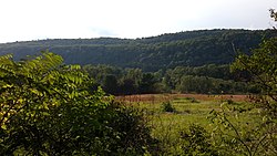
35:Wallpack Ridge seen from Mountain Road
751:Dingman's Ferry Dutch Reformed Church
384:Feiveson, Harold; Sinden, Frank; and
371:Witte, Ron W., and Monteverde Don H.
7:
14:
789:
756:George W. Childs Recreation Site
112:
105:
29:
540:Old Mine Road Historic District
240:) is a mountain located in the
463:Delaware Water Gap Toll Bridge
1:
242:Ridge and Valley Appalachians
806:Tocks Island Dam controversy
678:Cold Spring Farm Springhouse
483:Minisink Archaeological Site
473:Milford–Montague Toll Bridge
668:Capt. Jacob Shoemaker House
392:(1976); Albert, Richard C.
307:for the establishment of a
263:to the Walpack Bend in the
159:41.23367611°N 74.85281861°W
853:
683:Delaware Water Gap station
79:41.13545806°N 74.9096250°W
787:
723:Schoonover Mountain House
287:and its main tributaries
164:41.23367611; -74.85281861
126:Sussex County, New Jersey
99:
28:
23:
601:Worthington State Forest
309:National Recreation Area
84:41.13545806; -74.9096250
51:928 ft (283 m)
606:Mount Tammany Fire Road
275:from the valley of the
267:near Flatbrookville in
227:Restricted access roads
555:Pahaquarry Copper Mine
513:Foster–Armstrong House
468:Dingman's Ferry Bridge
245:physiographic province
708:Marie Zimmermann Farm
360:Unearthing New Jersey
330:Geology of New Jersey
305:National Park Service
300:controversial project
261:Port Jervis, New York
837:Ridges of New Jersey
728:Zion Lutheran Church
545:Cornelius Gunn House
518:Kittatinny Mountain
279:(also known as the
183:Kittatinny Mountain
155: /
75: /
773:Silverthread Falls
631:Big Bushkill Creek
448:Delaware Water Gap
441:Points of interest
41:Highest point
814:
813:
785:
784:
781:
780:
698:John Michael Farm
458:Appalachian Trail
293:Little Flat Brook
257:Montague Township
231:
230:
137:Range coordinates
844:
793:
792:
734:
560:Van Campen's Inn
496:
427:
420:
413:
404:
397:
382:
376:
369:
363:
356:
340:Van Campen's Inn
269:Walpack Township
251:in northwestern
178:
170:
169:
167:
166:
165:
160:
156:
153:
152:
151:
148:
116:
115:
109:
90:
89:
87:
86:
85:
80:
76:
73:
72:
71:
68:
33:
16:
852:
851:
847:
846:
845:
843:
842:
841:
817:
816:
815:
810:
794:
790:
777:
761:Deer Leap Falls
732:
617:
594:Wallpack Center
579:Wallpack Valley
494:
436:
431:
401:
400:
386:Socolow, Robert
383:
379:
370:
366:
357:
353:
348:
321:
273:Wallpack Valley
176:
163:
161:
157:
154:
149:
146:
144:
142:
141:
131:
130:
129:
128:
127:
124:
123:
122:
121:
117:
83:
81:
77:
74:
69:
66:
64:
62:
61:
36:
12:
11:
5:
850:
848:
840:
839:
834:
829:
819:
818:
812:
811:
809:
808:
802:
800:
796:
795:
788:
786:
783:
782:
779:
778:
776:
775:
770:
769:
768:
763:
753:
748:
746:Dingmans Falls
742:
740:
738:Dingmans Ferry
731:
730:
725:
720:
715:
713:Metz Ice Plant
710:
705:
703:John Turn Farm
700:
695:
690:
685:
680:
675:
670:
665:
663:Callahan House
660:
655:
650:
648:Brodhead Creek
645:
644:
643:
633:
627:
625:
619:
618:
616:
615:
614:
613:
608:
598:
597:
596:
591:
589:Flatbrookville
586:
576:
575:
574:
567:Wallpack Ridge
564:
563:
562:
557:
552:
547:
537:
532:
527:
526:
525:
515:
510:
504:
502:
493:
492:
487:
486:
485:
475:
470:
465:
460:
455:
453:Delaware River
450:
444:
442:
438:
437:
432:
430:
429:
422:
415:
407:
399:
398:
377:
364:
350:
349:
347:
344:
343:
342:
337:
332:
327:
320:
317:
289:Big Flat Brook
277:Delaware River
265:Delaware River
234:Wallpack Ridge
229:
228:
225:
221:
220:
216:
215:
209:
203:
202:
197:
191:
190:
186:
185:
180:
172:
171:
150:74°51′10.147″W
139:
133:
132:
125:
120:Wallpack Ridge
119:
118:
111:
110:
104:
103:
102:
101:
100:
97:
96:
92:
91:
59:
53:
52:
49:
43:
42:
38:
37:
34:
26:
25:
21:
20:
19:Wallpack Ridge
13:
10:
9:
6:
4:
3:
2:
849:
838:
835:
833:
830:
828:
825:
824:
822:
807:
804:
803:
801:
797:
774:
771:
767:
764:
762:
759:
758:
757:
754:
752:
749:
747:
744:
743:
741:
739:
735:
729:
726:
724:
721:
719:
716:
714:
711:
709:
706:
704:
701:
699:
696:
694:
693:Fort Hyndshaw
691:
689:
686:
684:
681:
679:
676:
674:
671:
669:
666:
664:
661:
659:
656:
654:
653:Brodhead Farm
651:
649:
646:
642:
639:
638:
637:
636:Blue Mountain
634:
632:
629:
628:
626:
624:
620:
612:
609:
607:
604:
603:
602:
599:
595:
592:
590:
587:
585:
582:
581:
580:
577:
573:
570:
569:
568:
565:
561:
558:
556:
553:
551:
550:Old Mine Road
548:
546:
543:
542:
541:
538:
536:
533:
531:
530:Military Road
528:
524:
523:Mount Tammany
521:
520:
519:
516:
514:
511:
509:
506:
505:
503:
501:
497:
491:
488:
484:
481:
480:
479:
476:
474:
471:
469:
466:
464:
461:
459:
456:
454:
451:
449:
446:
445:
443:
439:
435:
428:
423:
421:
416:
414:
409:
408:
405:
395:
391:
387:
381:
378:
374:
368:
365:
361:
355:
352:
345:
341:
338:
336:
335:Old Mine Road
333:
331:
328:
326:
323:
322:
318:
316:
314:
310:
306:
301:
296:
294:
290:
286:
282:
278:
274:
270:
266:
262:
258:
254:
250:
249:Sussex County
246:
243:
239:
238:Walpack Ridge
235:
226:
222:
217:
213:
210:
208:
207:Mountain type
204:
201:
200:Late Silurian
198:
196:
192:
187:
184:
181:
179:
173:
168:
147:41°14′1.234″N
140:
138:
134:
108:
98:
93:
88:
70:74°54′34.65″W
60:
58:
54:
50:
48:
44:
39:
32:
27:
24:Walpack Ridge
22:
17:
766:Fulmer Falls
623:Pennsylvania
611:Sunfish Pond
566:
393:
389:
380:
367:
354:
297:
237:
233:
232:
177:Parent range
67:41°8′7.649″N
641:Mount Minsi
572:Brau Kettle
325:Brau Kettle
195:Age of rock
162: /
82: /
57:Coordinates
821:Categories
673:Conashaugh
584:Flat Brook
500:New Jersey
490:Waterfalls
346:References
285:Flat Brook
253:New Jersey
718:Nyce Farm
535:Millbrook
259:south of
212:Dendritic
95:Geography
47:Elevation
658:Bushkill
478:Minisink
319:See also
281:Minisink
219:Climbing
799:History
688:Eshback
189:Geology
508:Bevans
224:Access
214:ridge
291:and
236:(or
247:in
823::
388:.
298:A
295:.
426:e
419:t
412:v
Text is available under the Creative Commons Attribution-ShareAlike License. Additional terms may apply.