34:
50:
57:
273:
572:
439:. The parish covers an area of 1,276 hectares (3,150 acres). In the 2001 census 1,930 people lived in 703 households, of whom 820 were economically active. At the 2011 Census the population of the civil parish was 1,867.
313:
177:
120:
297:
537:
367:
259:
1157:
640:
483:, a hill fort based ring of trees atop Chanctonbury Hill on the South Downs, lies on the border of the parish and the neighbouring parish of
49:
492:
290:
285:
302:
691:
1183:
349:
659:
247:
213:
1141:
359:
113:
544:
93:
1178:
408:
354:
971:
936:
931:
495:
as an uncommon woodland type on a chalk escarpment, providing habitat for many species including the protected
428:
227:
1116:
951:
881:
776:
509:
321:
1076:
751:
33:
891:
851:
741:
684:
513:
598:
1041:
1006:
821:
756:
159:
1136:
991:
484:
976:
496:
412:
203:
195:
167:
136:
103:
1081:
632:
1011:
861:
791:
636:
488:
480:
1111:
796:
701:
677:
252:
996:
1121:
961:
946:
464:, a primary school and a village hall with an adjoining sports field. The hamlet named
1172:
1086:
941:
916:
766:
625:
453:
278:
1091:
986:
911:
901:
811:
801:
143:
669:
1106:
1061:
1036:
966:
926:
816:
771:
761:
443:
424:
416:
185:
70:
1126:
1066:
1056:
1051:
1001:
826:
446:
382:
369:
921:
886:
876:
856:
736:
469:
237:
1071:
1046:
1026:
981:
956:
906:
866:
781:
746:
720:
450:
436:
420:
1131:
1096:
1021:
896:
871:
846:
841:
836:
831:
806:
786:
715:
457:
432:
404:
219:
664:
1031:
1016:
130:
673:
419:, England. It is located five miles (eight kilometres) west of
516:
in
Washington for the final years of his life and died there.
334:
1150:
729:
708:
330:
312:
296:
284:
272:
258:
246:
236:
226:
212:
194:
176:
158:
142:
128:
112:
101:
88:
80:
26:
624:
665:Official Website Of The Washington Parish Council
538:"2001 Census: West Sussex – Population by Parish"
685:
8:
627:The Harvard Biographical Dictionary of Music
543:. West Sussex County Council. Archived from
1158:List of civil parishes in Horsham district
692:
678:
670:
532:
530:
423:and three miles (five kilometres) east of
84:12.76 km (4.93 sq mi)
23:
16:Village and parish in West Sussex, England
599:"SSSI Citation — Chanctonbury Hill"
526:
329:
311:
267:
235:
211:
127:
111:
79:
30:
567:
565:
295:
283:
271:
257:
245:
225:
193:
175:
157:
100:
7:
631:. Harvard University Press. p.
442:The village lies at the foot of the
493:Site of Special Scientific Interest
56:
14:
579:. Office for National Statistics
55:
48:
32:
573:"Civil Parish population 2011"
1:
660:includes photograph of church
623:Randel, Don Michael (1996).
114:OS grid reference
21:Human settlement in England
1200:
468:lies to the north of the
340:
308:
268:
43:
31:
577:Neighbourhood Statistics
460:. There is one pub, the
1184:Villages in West Sussex
1117:West Chiltington Common
322:Arundel and South Downs
108:151/km (390/sq mi)
335:http://www.wpc.org.uk/
248:Postcode district
135:43 miles (69 km)
730:Villages and hamlets
383:50.90298°N 0.40634°W
228:Sovereign state
97:1,867 (2011 Census)
379: /
514:converted windmill
497:Great Crested Newt
388:50.90298; -0.40634
314:UK Parliament
260:Dialling code
1166:
1165:
792:Broadbridge Heath
642:978-0-674-37299-3
604:. Natural England
489:Chanctonbury Hill
481:Chanctonbury Ring
398:
397:
178:Shire county
1191:
1179:Horsham District
1112:West Chiltington
797:Broadford Bridge
702:Horsham District
700:Settlements in
694:
687:
680:
671:
647:
646:
630:
620:
614:
613:
611:
609:
603:
595:
589:
588:
586:
584:
569:
560:
559:
557:
555:
549:
542:
534:
456:is dedicated to
413:Horsham District
394:
393:
391:
390:
389:
384:
380:
377:
376:
375:
372:
346:
303:South East Coast
222:
124:
123:
69:Location within
59:
58:
52:
38:St Mary's Church
36:
24:
1199:
1198:
1194:
1193:
1192:
1190:
1189:
1188:
1169:
1168:
1167:
1162:
1146:
1082:Tisman's Common
997:Partridge Green
725:
704:
698:
656:
651:
650:
643:
622:
621:
617:
607:
605:
601:
597:
596:
592:
582:
580:
571:
570:
563:
553:
551:
547:
540:
536:
535:
528:
523:
505:
478:
387:
385:
381:
378:
373:
370:
368:
366:
365:
364:
344:
326:
218:
208:
190:
172:
154:
119:
118:
96:
76:
75:
74:
73:
67:
66:
65:
64:
60:
39:
22:
17:
12:
11:
5:
1197:
1195:
1187:
1186:
1181:
1171:
1170:
1164:
1163:
1161:
1160:
1154:
1152:
1151:Civil parishes
1148:
1147:
1145:
1144:
1139:
1134:
1129:
1124:
1122:West Grinstead
1119:
1114:
1109:
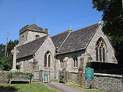
1104:
1099:
1094:
1089:
1084:
1079:
1074:
1069:
1064:
1059:
1054:
1049:
1044:
1039:
1034:
1029:
1024:
1019:
1014:
1009:
1004:
999:
994:
989:
984:
979:
974:
969:
964:
959:
954:
949:
947:Mannings Heath
944:
939:
934:
929:
924:
919:
914:
909:
904:
899:
894:
889:
884:
879:
874:
869:
864:
862:Dragon's Green
859:
854:
849:
844:
839:
834:
829:
824:
819:
814:
809:
804:
799:
794:
789:
784:
779:
774:
769:
764:
759:
754:
749:
744:
739:
733:
731:
727:
726:
724:
723:
718:
712:
710:
706:
705:
699:
697:
696:
689:
682:
674:
668:
667:
662:
655:
654:External links
652:
649:
648:
641:
615:
590:
561:
550:on 8 June 2011
525:
524:
522:
519:
518:
517:
504:
503:Notable people
501:
477:
474:
462:Frankland Arms
396:
395:
363:
362:
357:
352:
347:
345:List of places
341:
338:
337:
332:
328:
327:
325:
324:
318:
316:
310:
309:
306:
305:
300:
294:
293:
288:
282:
281:
276:
270:
269:
266:
265:
262:
256:
255:
250:
244:
243:
240:
234:
233:
232:United Kingdom
230:
224:
223:
216:
210:
209:
207:
206:
200:
198:
192:
191:
189:
188:
182:
180:
174:
173:
171:
170:
164:
162:
156:
155:
153:
152:
148:
146:
140:
139:
133:
126:
125:
116:
110:
109:
106:
99:
98:
90:
86:
85:
82:
78:
77:
68:
62:
61:
54:
53:
47:
46:
45:
44:
41:
40:
37:
29:
28:
20:
15:
13:
10:
9:
6:
4:
3:
2:
1196:
1185:
1182:
1180:
1177:
1176:
1174:
1159:
1156:
1155:
1153:
1149:
1143:
1140:
1138:
1135:
1133:
1130:
1128:
1125:
1123:
1120:
1118:
1115:
1113:
1110:
1108:
1105:
1103:
1100:
1098:
1095:
1093:
1090:
1088:
1087:Upper Beeding
1085:
1083:
1080:
1078:
1075:
1073:
1070:
1068:
1065:
1063:
1060:
1058:
1055:
1053:
1050:
1048:
1045:
1043:
1040:
1038:
1035:
1033:
1030:
1028:
1025:
1023:
1020:
1018:
1015:
1013:
1010:
1008:
1005:
1003:
1000:
998:
995:
993:
990:
988:
985:
983:
980:
978:
975:
973:
970:
968:
965:
963:
960:
958:
955:
953:
950:
948:
945:
943:
942:Lower Beeding
940:
938:
935:
933:
930:
928:
925:
923:
920:
918:
917:Kilnwood Vale
915:
913:
910:
908:
905:
903:
900:
898:
895:
893:
890:
888:
885:
883:
880:
878:
875:
873:
870:
868:
865:
863:
860:
858:
855:
853:
850:
848:
845:
843:
840:
838:
835:
833:
830:
828:
825:
823:
820:
818:
815:
813:
810:
808:
805:
803:
800:
798:
795:
793:
790:
788:
785:
783:
780:
778:
775:
773:
770:
768:
767:Billingshurst
765:
763:
760:
758:
755:
753:
750:
748:
745:
743:
740:
738:
735:
734:
732:
728:
722:
719:
717:
714:
713:
711:
707:
703:
695:
690:
688:
683:
681:
676:
675:
672:
666:
663:
661:
658:
657:
653:
644:
638:
634:
629:
628:
619:
616:
600:
594:
591:
578:
574:
568:
566:
562:
546:
539:
533:
531:
527:
520:
515:
511:
508:The composer
507:
506:
502:
500:
498:
494:
490:
486:
482:
475:
473:
471:
467:
463:
459:
455:
454:parish church
452:
448:
445:
440:
438:
434:
430:
426:
422:
418:
414:
410:
406:
402:
392:
361:
358:
356:
353:
351:
348:
343:
342:
339:
336:
333:
323:
320:
319:
317:
315:
307:
304:
301:
299:
292:
289:
287:
280:
277:
275:
263:
261:
254:
251:
249:
241:
239:
231:
229:
221:
217:
215:
205:
202:
201:
199:
197:
187:
184:
183:
181:
179:
169:
166:
165:
163:
161:
150:
149:
147:
145:
141:
138:
134:
132:
122:
117:
115:
107:
105:
95:
91:
87:
83:
72:
51:
42:
35:
25:
19:
1101:
1092:Warminghurst
987:Old Holbrook
912:Itchingfield
902:Heath Common
812:Codmore Hill
802:Brooks Green
626:
618:
606:. Retrieved
593:
581:. Retrieved
576:
552:. Retrieved
545:the original
510:John Ireland
479:
465:
461:
441:
409:civil parish
400:
399:
144:Civil parish
92:1,930
18:
1142:Woodmancote
1107:Watersfield
1062:Storrington
1037:Shermanbury
972:North Stoke
967:North Heath
962:Monk's Gate
937:Littleworth
932:Littlehaven
927:Lambs Green
817:Coldwaltham
772:Bines Green
762:Barns Green
512:lived in a
444:South Downs
425:Storrington
417:West Sussex
386: /
360:West Sussex
291:West Sussex
186:West Sussex
94:2001 Census
71:West Sussex
1173:Categories
1127:Wiggonholt
1102:Washington
1067:Sullington
1057:Southwater
1052:Small Dole
1002:Pulborough
952:Maplehurst
882:Gay Street
827:Coneyhurst
777:Blackstone
521:References
447:escarpment
401:Washington
371:50°54′11″N
242:PULBOROUGH
204:South East
151:Washington
89:Population
63:Washington
27:Washington
1077:The Haven
977:Nutbourne
922:Kingsfold
887:Graylands
877:Five Oaks
857:Dial Post
752:Ashington
747:Annington
737:Adversane
583:4 October
476:Landmarks
470:A283 road
374:0°24′23″W
298:Ambulance
238:Post town
1072:Thakeham
1047:Slinfold
1027:Rudgwick
982:Nuthurst
957:Marehill
907:Henfield
892:Greatham
867:Edburton
852:Crabtree
782:Botolphs
742:Amberley
721:Steyning
554:12 April
451:Anglican
437:Worthing
431:between
421:Steyning
160:District
121:TQ121127
1132:Wineham
1097:Warnham
1042:Shipley
1022:Rowhook
1007:Rackham
897:Hardham
872:Faygate
847:Cowfold
842:Copsale
837:Cootham
832:Coolham
822:Colgate
807:Buncton
787:Bramber
757:Ashurst
716:Horsham
608:4 April
458:St Mary
433:Horsham
427:on the
411:in the
405:village
355:England
331:Website
220:England
214:Country
168:Horsham
129:•
104:Density
102:•
1137:Wiston
1032:Rusper
1017:Roffey
992:Parham
639:
485:Wiston
449:. The
279:Sussex
274:Police
196:Region
131:London
709:Towns
602:(PDF)
548:(PDF)
541:(PDF)
491:is a
403:is a
264:01903
1012:Rock
637:ISBN
610:2009
585:2016
556:2009
466:Rock
435:and
407:and
286:Fire
253:RH20
81:Area
633:407
429:A24
415:of
137:NNE
1175::
635:.
575:.
564:^
529:^
499:.
487:.
472:.
350:UK
693:e
686:t
679:v
645:.
612:.
587:.
558:.
Text is available under the Creative Commons Attribution-ShareAlike License. Additional terms may apply.