55:
391:
95:
379:
367:
38:
102:
62:
579:
350:
301:
Formerly a farming community with its own church, school, and shops, the whole village was scheduled for demolition in the 1970s to allow the industrial area of
Delfzijl harbour to be expand. Less than 10% of the original buildings are left. The school and the cemetery have remained. The
354:
351:
353:
337:
In 1840, Weiwerd was home to 311 people. Prior to the demolition order, it was home to over 300 peoples. In 2015, the last two inhabitants left the village. Even though the village has no inhabitants, it still has place name signs.
352:
54:
611:
966:
961:
94:
942:
604:
234:
597:
246:
621:
378:
366:
130:
390:
308:(artificial living hill) was supposed to be excavated as well, however protests have prevented its destruction, and the
37:
320:
The village was first mentioned in the 10th or 11th century as UUahcuurð. The etymology is unclear. Weiwerd is a
670:
287:
175:
75:
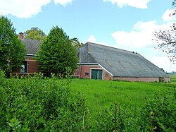
858:
756:
589:
583:
519:
971:
921:
846:
692:
824:
812:
875:
768:
724:
270:
780:
792:
295:
422:
265:
955:
926:
863:
807:
761:
885:
841:
687:
327:
283:
165:
79:
851:
697:
880:
751:
746:
639:
548:
145:
132:
870:
836:
802:
736:
709:
665:
625:
291:
185:
829:
817:
578:
895:
773:
729:
714:
704:
644:
278:
916:
911:
890:
785:
741:
719:
682:
331:
490:
797:
660:
675:
447:
322:
304:
593:
360:
Aerial view of the village and images of its destruction
904:
653:
632:
245:
233:
225:
217:
212:
204:
196:
191:
181:
171:
161:
21:
330:. It has a radial structure and located near the
943:List of cities, towns and villages in Groningen
605:
8:
967:1970s disestablishments in the Netherlands
962:Former populated places in the Netherlands
612:
598:
590:
18:
485:
483:
481:
16:Former village in Groningen, Netherlands
407:
345:
232:
211:
203:
190:
160:
125:
46:
34:
543:
541:
514:
512:
475:, Topografische Dienst and ANWB, 2005.
417:
415:
413:
411:
290:. It is a part of the municipality of
277:
264:
244:
224:
216:
195:
180:
170:
7:
423:"Kerncijfers wijken en buurten 2021"
294:, and lies about 27 km east of
200:0.12 km (0.05 sq mi)
520:"Monumentnummer: 45306 te Farmsum"
473:ANWB Topografische Atlas Nederland
14:
577:
389:
377:
365:
348:
100:
93:
84:Show map of Groningen (province)
60:
53:
36:
549:"Weiwerd - (geografische naam)"
454:(in Dutch). Het Waterschapshuis
452:Actueel Hoogtebestand Nederland
101:
61:
1:
312:is now a protected monument.
282:) is a former village in the
427:Central Bureau of Statistics
74:Location in the province of
384:The empty fields of Weiwerd
988:
326:village from the start of
940:
448:"Postcodetool for 9936AC"
126:
47:
35:
28:
620:Populated places in the
524:Dutch Monuments Register
208:0.5 m (1.6 ft)
274:
229:0.0/km (0.0/sq mi)
117:Show map of Netherlands
114:Weiwerd (Netherlands)
586:at Wikimedia Commons
262:Dutch pronunciation:
226: • Density
279:[ˈʋɑːɪ̯ʋət]
142: /
266:[ˈʋɛiʋərt]
218: • Total
197: • Total
949:
948:
582:Media related to
372:Derelict building
355:
255:
254:
979:
867:
855:
833:
821:
789:
777:
765:
733:
701:
679:
614:
607:
600:
591:
581:
565:
564:
562:
560:
545:
536:
535:
533:
531:
516:
507:
506:
504:
502:
487:
476:
470:
464:
463:
461:
459:
444:
438:
437:
435:
433:
419:
393:
381:
369:
357:
356:
281:
268:
263:
157:
156:
154:
153:
152:
147:
146:53.317°N 6.950°E
143:
140:
139:
138:
135:
118:
104:
103:
97:
85:
64:
63:
57:
40:
19:
987:
986:
982:
981:
980:
978:
977:
976:
952:
951:
950:
945:
936:
900:
861:
849:
827:
815:
783:
771:
759:
727:
695:
673:
649:
628:
618:
574:
569:
568:
558:
556:
547:
546:
539:
529:
527:
518:
517:
510:
500:
498:
489:
488:
479:
471:
467:
457:
455:
446:
445:
441:
431:
429:
421:
420:
409:
404:
397:
394:
385:
382:
373:
370:
361:
358:
349:
344:
318:
261:
241:
150:
148:
144:
141:
136:
133:
131:
129:
128:
122:
121:
120:
119:
116:
115:
112:
111:
110:
109:
105:
88:
87:
86:
83:
82:
72:
71:
70:
69:
65:
43:
31:
24:
17:
12:
11:
5:
985:
983:
975:
974:
969:
964:
954:
953:
947:
946:
941:
938:
937:
935:
934:
929:
924:
919:
914:
908:
906:
902:
901:
899:
898:
893:
888:
883:
878:
873:
868:
859:Westerwijtwerd
856:
844:
839:
834:
822:
810:
805:
800:
795:
790:
778:
766:
757:Oosterwijtwerd
754:
749:
744:
739:
734:
722:
717:
712:
707:
702:
690:
685:
680:
668:
663:
657:
655:
651:
650:
648:
647:
642:
636:
634:
630:
629:
619:
617:
616:
609:
602:
594:
588:
587:
573:
572:External links
570:
567:
566:
553:Etymologiebank
537:
508:
477:
465:
439:
406:
405:
403:
400:
399:
398:
395:
388:
386:
383:
376:
374:
371:
364:
362:
359:
347:
343:
340:
317:
314:
253:
252:
249:
243:
242:
239:
237:
231:
230:
227:
223:
222:
219:
215:
214:
210:
209:
206:
202:
201:
198:
194:
193:
189:
188:
183:
179:
178:
173:
169:
168:
163:
159:
158:
124:
123:
113:
107:
106:
99:
98:
92:
91:
90:
89:
73:
67:
66:
59:
58:
52:
51:
50:
49:
48:
45:
44:
41:
33:
32:
30:Former village
29:
26:
25:
22:
15:
13:
10:
9:
6:
4:
3:
2:
984:
973:
970:
968:
965:
963:
960:
959:
957:
944:
939:
933:
930:
928:
927:Startenhuizen
925:
923:
920:
918:
915:
913:
910:
909:
907:
903:
897:
894:
892:
889:
887:
884:
882:
879:
877:
874:
872:
869:
865:
860:
857:
853:
848:
845:
843:
840:
838:
835:
831:
826:
823:
819:
814:
811:
809:
808:Termunterzijl
806:
804:
801:
799:
796:
794:
791:
787:
782:
779:
775:
770:
767:
763:
758:
755:
753:
750:
748:
745:
743:
740:
738:
735:
731:
726:
723:
721:
718:
716:
713:
711:
708:
706:
703:
699:
694:
691:
689:
686:
684:
681:
677:
672:
669:
667:
664:
662:
659:
658:
656:
652:
646:
643:
641:
638:
637:
635:
631:
627:
623:
615:
610:
608:
603:
601:
596:
595:
592:
585:
580:
576:
575:
571:
554:
550:
544:
542:
538:
525:
521:
515:
513:
509:
496:
492:
486:
484:
482:
478:
474:
469:
466:
453:
449:
443:
440:
428:
424:
418:
416:
414:
412:
408:
401:
396:Former school
392:
387:
380:
375:
368:
363:
346:
341:
339:
335:
333:
329:
325:
324:
315:
313:
311:
307:
306:
299:
297:
293:
289:
285:
280:
276:
272:
267:
259:
250:
248:
238:
236:
228:
220:
207:
199:
187:
184:
177:
174:
167:
164:
155:
151:53.317; 6.950
127:Coordinates:
96:
81:
77:
56:
39:
27:
20:
931:
622:municipality
557:. Retrieved
552:
528:. Retrieved
523:
499:. Retrieved
495:Plaatsengids
494:
472:
468:
456:. Retrieved
451:
442:
430:. Retrieved
426:
336:
321:
319:
309:
303:
300:
286:province of
257:
256:
247:Dialing code
182:Municipality
42:Farm in 2011
862: [
850: [
847:Westeremden
842:Wagenborgen
828: [
816: [
784: [
772: [
760: [
728: [
696: [
693:Garsthuizen
688:Garrelsweer
674: [
235:Postal code
166:Netherlands
149: /
80:Netherlands
956:Categories
881:Woldendorp
752:Middelstum
747:Meedhuizen
640:Appingedam
555:(in Dutch)
526:(in Dutch)
497:(in Dutch)
402:References
213:Population
972:Eemsdelta
871:Winneweer
837:Uitwierde
825:Toornwerd
813:Tjamsweer
803:Termunten
737:Loppersum
710:Holwierde
666:Borgsweer
626:Eemsdelta
491:"Weiwerd"
296:Groningen
292:Eemsdelta
288:Groningen
205:Elevation
186:Eemsdelta
176:Groningen
76:Groningen
896:Zijldijk
886:'t Zandt
769:Opwierde
725:Leermens
715:Huizinge
705:Godlinze
654:Villages
645:Delfzijl
275:Waaiwerd
271:Gronings
172:Province
932:Weiwerd
917:Biessum
912:Amsweer
905:Hamlets
891:Zeerijp
781:Solwerd
742:Losdorp
720:Krewerd
683:Farmsum
584:Weiwerd
559:8 April
530:8 April
501:8 April
458:8 April
432:8 April
342:Gallery
332:Dollart
328:our era
316:History
258:Weiwerd
162:Country
134:53°19′N
108:Weiwerd
78:in the
68:Weiwerd
23:Weiwerd
876:Wirdum
798:Stedum
661:Bierum
137:6°57′E
922:Oling
866:]
854:]
832:]
820:]
793:Spijk
788:]
776:]
764:]
732:]
700:]
678:]
671:Eenum
633:Towns
284:Dutch
561:2022
532:2022
503:2022
460:2022
434:2022
323:terp
310:terp
305:terp
251:0596
240:9936
192:Area
624:of
298:.
958::
864:nl
852:nl
830:nl
818:nl
786:nl
774:nl
762:nl
730:nl
698:nl
676:nl
551:.
540:^
522:.
511:^
493:.
480:^
450:.
425:.
410:^
334:.
273::
269:;
613:e
606:t
599:v
563:.
534:.
505:.
462:.
436:.
260:(
221:0
Text is available under the Creative Commons Attribution-ShareAlike License. Additional terms may apply.