226:
collapsed. In a bloodless coup, Lieutenant Yahya Jamme in 1994 and went on to win multi party elections in three subsequent elections. He has also defeated coups successfully and unlike the West
African countries, the Gambia has a relative stable governance. The Local Govemment Act passed in 2002 superseded the previous local government acts like Local Government Act (Amended 1984), Local Government (City of Banjul) Act (Amended 1988), The Kanifing Municipal Council Act 1991 and the Provinces Act. There were seven local governments defined each subdivided into districts and wards. The Mayor who is the chairperson of the council and the council members of each council is elected by people of the area. The legislations indicating the roles were not clearly defined, but the council is responsible for finance, services and planning for each sector under it. Around 25 per cent of the budget is provisioned by the central government. The council also has a
171:
52:
218:
209:
per every thousand births. The poverty gap ratio was 22.4 per cent as of 2003. The literacy rate of the province was 69.7 compared to a national average of 62.9 per cent. The net enrollment ratio in primary education was 70 per cent, children entering first grade of primary school reaching last grade of primary education was 99.5 per cent and the ratios of boys against girls in primary, secondary and tertiary education was 1.03 as of 2007.
200:. The months from June to September experience a wet season, while the remaining seven months are dry. The average annual rainfall is around 1,400 mm (55 in) in the south east, while it is 720 mm (28 in) in the northwest. Experts have assessed that the overall rainfall during the century period between 1886 and 1992, there has been a reduction in rainfall of around 15-20 per cent and the wet season has been shortened.
566:
43:
68:
281:. The city and area council elections were held during April 2002, when Ahmed Gibril Jassy, an APRC candidate became the Mayor, winning unopposed. The council was led by Alliance for Patriotic Reorientation and Construction (APRC), which won 22 out of the 24 seats, with the other two seats won by independents.
225:
The Gambia along with modern-day
Senegal were colonies of French and British until 1894 when it became a British colony. Both the countries got independence in 1965 and operated in a federation called Senegambia from 1982.Senegal gained independence in 1960 not 1965. During 1989, the confederation
208:
Per 2013 census, the region had a population of 699,704 with a population density of 397. The total number of households was 45,396 as of 2003. As of 2003, the total area of the region is 1764.3 km. The infant mortality rate was 71 for every thousand births and the under-five mortality was 93
161:
Per 2013 census, the region had a population of 699,704 with a population density of 397. The total number of households was 45,396 as of 2003. As of 2003, the total area of the region is 1764.3 km. The infant mortality rate was 71 for every thousand births and the under-five mortality was 93
190:
flows throughout the country and is the principal source of water and a transport route. The banks of the river have swampy beaches, while it has alluvial soil in all other parts, which is conducive for the growth of rice. Peanuts are the major cash crop. The weather is usually warm and dry. The
195:
and has an east–west axis. The shallow water in the coastline are important sources of fishing. They are mangrove and banto forests along the coastline. Over the river segment of 487 km (303 mi), there are numerous creeks, which are locally called
191:
elevation of the country reaches to a maximum of 50 m (160 ft) above the mean sea level. There are vast segments of sedimentary sandstone and claystone in the valleys of the rivers and the regions surrounding it. The river flows from
554:
547:
540:
532:
182:
and the width of the strip-like structure never exceeds 48 km (30 mi). It is bordered by the
Atlantic Ocean to the west, and otherwise surrounded by
959:
581:
234:
representative, the representative of the Chief, a youth nominee, a woman nominee and other nominated members of local interest groups.
51:
374:
347:
320:
920:
964:
412:
310:
854:
337:
364:
570:
162:
per every thousand births. The poverty gap ratio was 22.4 per cent and literacy rate was 69.7 per cent as of 2003.
434:
124:
640:
636:
290:
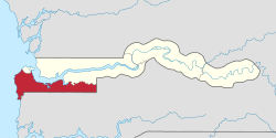
242:
143:
33:
478:
897:
672:
274:
527:
862:
821:
735:
685:
246:
778:
170:
390:
662:
370:
343:
316:
834:
695:
217:
155:
484:(Report). Department of Economic and Social Affairs (DESA), United Nations. 2004. p. 7
786:
839:
710:
594:
503:
42:
953:
887:
844:
806:
796:
758:
743:
720:
266:
882:
867:
829:
725:
705:
700:
690:
680:
262:
250:
187:
456:
902:
877:
872:
811:
801:
624:
604:
278:
258:
254:
238:
83:
892:
768:
763:
753:
748:
573:
565:
270:
147:
73:
935:
922:
609:
715:
619:
614:
599:
183:
151:
791:
657:
649:
589:
192:
179:
216:
169:
479:
536:
336:
Emms, Craig; Barnett, Linda; Human, Richard (2006).
853:
820:
777:
734:
671:
648:
633:
580:
142:, also known as Foni or Fonyi, was one of the five
123:
115:
107:
102:
94:
89:
79:
61:
24:
158:(LGA), without any change in the area covered.
548:
504:"25 April 2002 Local Elections in The Gambia"
56:Location of West Coast Division in the Gambia
8:
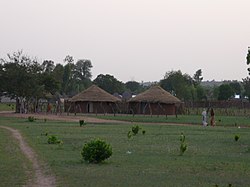
645:
555:
541:
533:
21:
391:"Socio-economic statistics of The Gambia"
312:Encyclopedia of World Geography, Volume 1
154:. It was subsequently reorganised as the
301:
122:
101:
88:
78:
60:
48:
39:
435:"Educational statistics of The Gambia"
178:The Gambia is the smallest country in
114:
106:
93:
16:Administrative division of the Gambia
7:
315:. Infobase Publishing. p. 351.
437:. Gambia Bureau of Statistics. 2007
415:. Gambia Bureau of Statistics. 2013
393:. Gambia Bureau of Statistics. 2013
98:1,764 km (681 sq mi)
14:
960:West Coast Division (The Gambia)
564:
66:
50:
41:
366:Flowering Plants of the Gambia
221:Districts of West Coast Region
1:
156:Brikama Local Government Area
506:. African Elections Database
457:"The Gambia country profile"
571:Administrative divisions of
528:New name for Western Region
237:West Coast Region, now the
981:
119:400/km (1,000/sq mi)
49:
40:
31:
363:Jones, Michaeal (1994).
174:A market in the province
144:administrative divisions
965:Divisions of the Gambia
342:. Bradt Travel Guides.
291:Districts of the Gambia
241:, is divided into nine
898:Kombo North/Saint Mary
673:Central River Division
582:Local Government Areas
413:"Census of The Gambia"
309:McColl, R. W. (2014).
275:Kombo North/Saint Mary
222:
175:
220:
173:
863:Foni Bintang-Karenai
822:Upper River Division
736:Lower River Division
459:. BBC. 5 August 2016
247:Foni Bintang-Karenai
213:Local administration
116: • Density
932: /
779:North Bank Division
634:National capital,
223:
176:
150:. Its capital was
108: • Total
95: • Total
19:Division in Gambia
936:13.250°N 16.317°W
915:
914:
911:
910:
138:, originally the
136:West Coast Region
133:
132:
972:
947:
946:
944:
943:
942:
937:
933:
930:
929:
928:
925:
696:Niamina Dankunku
646:
569:
568:
557:
550:
543:
534:
516:
515:
513:
511:
500:
494:
493:
491:
489:
483:
475:
469:
468:
466:
464:
453:
447:
446:
444:
442:
431:
425:
424:
422:
420:
409:
403:
402:
400:
398:
387:
381:
380:
360:
354:
353:
333:
327:
326:
306:
140:Western Division
72:
70:
69:
54:
45:
22:
980:
979:
975:
974:
973:
971:
970:
969:
950:
949:
941:13.250; -16.317
940:
938:
934:
931:
926:
923:
921:
919:
918:
916:
907:
849:
816:
787:Central Baddibu
773:
730:
667:
658:Banjul District
635:
629:
576:
563:
561:
524:
519:
509:
507:
502:
501:
497:
487:
485:
481:
477:
476:
472:
462:
460:
455:
454:
450:
440:
438:
433:
432:
428:
418:
416:
411:
410:
406:
396:
394:
389:
388:
384:
377:
362:
361:
357:
350:
335:
334:
330:
323:
308:
307:
303:
299:
287:
215:
206:
168:
67:
65:
57:
36:
27:
20:
17:
12:
11:
5:
978:
976:
968:
967:
962:
952:
951:
913:
912:
909:
908:
906:
905:
900:
895:
890:
885:
880:
875:
870:
865:
859:
857:
851:
850:
848:
847:
842:
837:
832:
826:
824:
818:
817:
815:
814:
809:
804:
799:
794:
789:
783:
781:
775:
774:
772:
771:
766:
761:
756:
751:
746:
740:
738:
732:
731:
729:
728:
723:
718:
713:
708:
703:
698:
693:
688:
683:
677:
675:
669:
668:
666:
665:
660:
654:
652:
643:
631:
630:
628:
627:
622:
617:
612:
607:
602:
597:
592:
586:
584:
578:
577:
562:
560:
559:
552:
545:
537:
531:
530:
523:
522:External links
520:
518:
517:
495:
470:
448:
426:
404:
382:
375:
355:
348:
328:
321:
300:
298:
295:
294:
293:
286:
283:
214:
211:
205:
202:
167:
164:
131:
130:
127:
121:
120:
117:
113:
112:
109:
105:
104:
100:
99:
96:
92:
91:
87:
86:
81:
77:
76:
63:
59:
58:
55:
47:
46:
38:
37:
32:
29:
28:
25:
18:
15:
13:
10:
9:
6:
4:
3:
2:
977:
966:
963:
961:
958:
957:
955:
948:
945:
904:
901:
899:
896:
894:
891:
889:
888:Kombo Central
886:
884:
881:
879:
876:
874:
871:
869:
866:
864:
861:
860:
858:
856:
852:
846:
843:
841:
838:
836:
833:
831:
828:
827:
825:
823:
819:
813:
810:
808:
807:Upper Baddibu
805:
803:
800:
798:
797:Lower Baddibu
795:
793:
790:
788:
785:
784:
782:
780:
776:
770:
767:
765:
762:
760:
759:Kiang Central
757:
755:
752:
750:
747:
745:
744:Jarra Central
742:
741:
739:
737:
733:
727:
724:
722:
719:
717:
714:
712:
709:
707:
704:
702:
699:
697:
694:
692:
689:
687:
684:
682:
679:
678:
676:
674:
670:
664:
661:
659:
656:
655:
653:
651:
647:
644:
642:
638:
632:
626:
623:
621:
618:
616:
613:
611:
608:
606:
603:
601:
598:
596:
593:
591:
588:
587:
585:
583:
579:
575:
572:
567:
558:
553:
551:
546:
544:
539:
538:
535:
529:
526:
525:
521:
505:
499:
496:
480:
474:
471:
458:
452:
449:
436:
430:
427:
414:
408:
405:
392:
386:
383:
378:
376:9789054101970
372:
369:. CRC Press.
368:
367:
359:
356:
351:
349:9781841621371
345:
341:
340:
332:
329:
324:
322:9780816072293
318:
314:
313:
305:
302:
296:
292:
289:
288:
284:
282:
280:
276:
272:
268:
267:Kombo Central
264:
260:
256:
252:
248:
244:
240:
235:
233:
229:
219:
212:
210:
203:
201:
199:
194:
189:
185:
181:
172:
165:
163:
159:
157:
153:
149:
145:
141:
137:
128:
126:
118:
110:
97:
85:
82:
75:
64:
53:
44:
35:
30:
23:
917:
883:Foni Kansala
868:Foni Bondali
830:Fulladu East
726:Upper Saloum
706:Niamina West
701:Niamina East
691:Lower Saloum
681:Fulladu West
508:. Retrieved
498:
486:. Retrieved
473:
461:. Retrieved
451:
439:. Retrieved
429:
417:. Retrieved
407:
395:. Retrieved
385:
365:
358:
338:
331:
311:
304:
263:Foni Kansala
251:Foni Bondali
236:
231:
227:
224:
207:
204:Demographics
197:
188:Gambia River
177:
160:
139:
135:
134:
939: /
903:Kombo South
878:Foni Jarrol
873:Foni Brefet
812:Upper Niumi
802:Lower Niumi
686:Janjanbureh
650:Banjul City
625:Mansa Konko
605:Janjanbureh
510:25 November
488:17 November
463:20 November
441:25 November
419:25 November
397:25 November
279:Kombo South
259:Foni Jarrol
255:Foni Brefet
239:Brikama LGA
84:Brikama LGA
954:Categories
893:Kombo East
855:West Coast
769:Kiang West
764:Kiang East
754:Jarra West
749:Jarra East
574:the Gambia
339:The Gambia
297:References
271:Kombo East
245:, namely,
148:the Gambia
103:Population
26:West Coast
641:Districts
637:Divisions
243:districts
166:Geography
125:Area code
663:Kanifing
610:Kanifing
285:See also
34:Division
927:16°19′W
924:13°15′N
835:Kantora
716:Nianija
620:Kuntaur
615:Kerewan
600:Brikama
198:boloons
184:Senegal
152:Brikama
111:699,704
80:Capital
62:Country
792:Jokadu
590:Banjul
373:
346:
319:
228:Alkalo
193:Guinea
186:. The
180:Africa
129:(+220)
74:Gambia
71:
840:Sandu
711:Niani
595:Basse
482:(PDF)
232:Seyfo
845:Wuli
721:Sami
639:and
512:2016
490:2016
465:2016
443:2016
421:2016
399:2016
371:ISBN
344:ISBN
317:ISBN
277:and
90:Area
230:or
146:of
956::
273:,
269:,
265:,
261:,
257:,
253:,
249:,
556:e
549:t
542:v
514:.
492:.
467:.
445:.
423:.
401:.
379:.
352:.
325:.
Text is available under the Creative Commons Attribution-ShareAlike License. Additional terms may apply.