34:
415:
50:
882:
471:
57:
209:
406:
is one of the oldest pubs in Dorset, dating from the 16th century. Holy
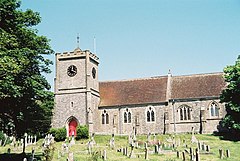
Trinity parish church was originally in the village centre, but was demolished in 1869 although the old churchyard still remains. The present church, built of local stone taken from the cove, replaced it. It was largely financed
424:
From the late seventeenth to the mid nineteenth century smugglers used
Lulworth Cove and other bays and beaches nearby. The building of coastguard cottages, which housed the customs officers still stand above the cove. Lulworth at one point had a mill, powered by water from a nearby spring. It was
548:. Scheduled buses run to Weymouth and Poole. Transport and car parking infrastructure has been a problem for the village in recent decades due to the volume and seasonal nature of the tourist traffic, with reported problems including car parks overflowing and traffic blocking emergency access.
582:
500:
and a general store. Commercial fishing is based at the cove, together with scallop diving and leisure trips. The stores and hotels line the route between the town and the cove, with several small stores selling locally caught seafood.
249:
123:
480:
West
Lulworth village is about one-half mile (0.80 km) north of Lulworth Cove, a picturesque, sheltered bay enclosed almost in a circle. The natural limestone arch of
824:
400:
was Aiulf the chamberlain. Despite this, East and West
Lulworth may have been separate settlements at this time, and definitely were so by the end of the 13th century.
233:
96:
226:
33:
1097:
525:
257:
783:
648:
293:
638:
797:
221:
463:, a 170 metres (560 ft) high ridge, which has extensive remains of Iron Age earthworks. To the west is Hambury Tout, which has a
856:
49:
275:
238:
193:
159:
516:. This ward extends northwards from the Cove to East Stoke and the intermediate area. The total population of the ward at the
433:
737:"'Lulworth, West', in An Inventory of the Historical Monuments in Dorset, Volume 2, South east (London, 1970), pp. 151-154"
521:
89:
834:
1092:
484:
is one mile (1.6 km) west along the coast from
Lulworth Cove. About 100 metres (330 ft) west of the cove is
517:
350:
113:
330:
280:
414:
285:
173:
1102:
931:
762:
849:
557:
545:
105:
784:"Now Lulworth is getting more parking restrictions to cope with tourist traffic | Bournemouth Echo"
510:
361:
972:
946:
453:
149:
141:
671:
444:
West
Lulworth civil parish covers 2,593 acres (1,049 ha). The underlying geology is mostly
736:
1054:
966:
956:
951:
722:
644:
1008:
978:
866:
842:
393:
198:
1071:
1043:
998:
988:
916:
536:
West
Lulworth is the terminus of the B3070 road which runs 5 miles (8.0 km) from the
428:
West
Lulworth is also the location of the only building designed by the eminent architect
425:
burnt down during the 19th century and all that remains of its existence is the millpond.
397:
342:
452:
along the coast. At
Lulworth Cove the sea has breached the limestone and eroded the soft
815:
West
Lulworth: an iconic heritage awaits - Information on West Lulworth past and present
1025:
983:
881:
513:
449:
403:
358:
357:
army base—had 291 households and a population of 714. The village is a gateway to the
1086:
1036:
993:
941:
926:
921:
911:
562:
429:
418:
377:
373:
354:
346:
214:
470:
1060:
896:
541:
497:
408:
829:
496:
West Lulworth village has a first school, a youth hostel, several small hotels,
481:
474:
460:
1003:
961:
936:
901:
485:
798:"West Lulworth car parks full - visitors urged to go elsewhere | Dorset Echo"
608:
308:
295:
906:
891:
537:
183:
583:"Area: West Lulworth (Parish). Key Figures for 2011 Census: Key Statistics"
1013:
1066:
1030:
1019:
464:
334:
165:
870:
697:
407:
by the then incumbent Rev. William Gildea, brother of philanthropist
338:
131:
70:
819:
469:
445:
432:
in the county of Dorset. Weston was built in 1927 for the surgeon
413:
459:
West Lulworth village is dominated by two hills: to the east is
364:
and is a popular tourist destination, especially for day trips.
838:
814:
376:
West Lulworth was not distinguished from neighbouring
456:
behind, resulting in the circular shape of the cove.
248:
232:
220:
208:
192:
182:
172:
158:
140:
122:
104:
88:
80:
26:
488:, a geological formation of caves with blowholes.
850:
820:Lulworth Online - Information on the villages
8:
640:The Domesday Geography of South-West England
520:was 1,464. West Purbeck ward is part of the
632:
630:
380:; only one settlement was recorded, called
16:Village and civil parish in Dorset, England
857:
843:
835:
643:. Cambridge University Press. p. 72.
23:
672:"Place: [East and West] Lulworth"
436:after he was left a legacy by a friend.
353:the civil parish—which includes most of
574:
544:. The nearest rail access is also from
247:
203:
181:
157:
87:
30:
231:
219:
207:
191:
171:
139:
121:
103:
56:
7:
865:Towns, villages and hamlets in the
1098:Populated coastal places in Dorset
14:
392:. It had 38.3 households, was in
38:Parish church of the Holy Trinity
880:
589:. Office for National Statistics
55:
48:
32:
1:
522:UK Parliamentary Constituency
825:West Lulworth on Google Maps
743:. University of London. 2014
830:West Lulworth Local History
90:OS grid reference
21:Human settlement in England
1119:
702:www.westlulworth-pc.org.uk
637:Darby, H; Finn, R (1967).
887:
878:
509:West Lulworth is part of
266:
244:
204:
43:
31:
763:"West Purbeck ward 2011"
613:The Domesday Book Online
587:Neighbourhood Statistics
434:Sir Alfred Downing Fripp
741:British History Online
477:
421:
194:Postcode district
106:Unitary authority
473:
417:
615:. domesdaybook.co.uk
558:West Lulworth Priory
546:Wool railway station
467:on its rounded top.
227:Dorset and Wiltshire
174:Sovereign state
678:. domesdaymap.co.uk
362:World Heritage Site
305: /
1093:Villages in Dorset
973:Lytchett Matravers
478:
450:Portland limestone
448:, with a strip of
422:
341:, situated on the
309:50.6261°N 2.2476°W
250:UK Parliament
1080:
1079:
1055:Winfrith Newburgh
967:Langton Matravers
650:978-0-521-04771-5
430:Sir Edwin Lutyens
396:and the lord and
329:is a village and
324:
323:
124:Shire county
1110:
1009:Stoborough Green
979:Lytchett Minster
884:
859:
852:
845:
836:
802:
801:
794:
788:
787:
780:
774:
773:
771:
769:
759:
753:
752:
750:
748:
733:
727:
726:
719:
713:
712:
710:
708:
694:
688:
687:
685:
683:
668:
662:
661:
659:
657:
634:
625:
624:
622:
620:
605:
599:
598:
596:
594:
579:
394:Winfrith Hundred
320:
319:
317:
316:
315:
314:50.6261; -2.2476
310:
306:
303:
302:
301:
298:
272:
168:
100:
99:
69:Location within
59:
58:
52:
36:
24:
1118:
1117:
1113:
1112:
1111:
1109:
1108:
1107:
1083:
1082:
1081:
1076:
1072:Worth Matravers
917:Chaldon Herring
885:
874:
863:
811:
806:
805:
796:
795:
791:
782:
781:
777:
767:
765:
761:
760:
756:
746:
744:
735:
734:
730:
721:
720:
716:
706:
704:
696:
695:
691:
681:
679:
670:
669:
665:
655:
653:
651:
636:
635:
628:
618:
616:
607:
606:
602:
592:
590:
581:
580:
576:
571:
554:
534:
507:
494:
442:
409:Sir James Gidea
398:tenant-in-chief
372:In 1086 in the
370:
343:English Channel
313:
311:
307:
304:
299:
296:
294:
292:
291:
290:
270:
262:
164:
154:
136:
118:
95:
94:
76:
75:
74:
73:
67:
66:
65:
64:
60:
39:
22:
17:
12:
11:
5:
1116:
1114:
1106:
1105:
1103:Jurassic Coast
1100:
1095:
1085:
1084:
1078:
1077:
1075:
1074:
1069:
1064:
1057:
1052:
1047:
1040:
1033:
1028:
1026:Turners Puddle
1023:
1016:
1011:
1006:
1001:
996:
991:
986:
981:
976:
969:
964:
959:
954:
952:Harman's Cross
949:
944:
939:
934:
929:
924:
919:
914:
909:
904:
899:
894:
888:
886:
879:
876:
875:
864:
862:
861:
854:
847:
839:
833:
832:
827:
822:
817:
810:
809:External links
807:
804:
803:
789:
775:
754:
728:
714:
689:
663:
649:
626:
600:
573:
572:
570:
567:
566:
565:
560:
553:
550:
533:
530:
514:electoral ward
506:
503:
493:
490:
441:
438:
404:The Castle Inn
369:
366:
359:Jurassic Coast
322:
321:
289:
288:
283:
278:
273:
271:List of places
267:
264:
263:
261:
260:
254:
252:
246:
245:
242:
241:
236:
230:
229:
224:
218:
217:
212:
206:
205:
202:
201:
196:
190:
189:
186:
180:
179:
178:United Kingdom
176:
170:
169:
162:
156:
155:
153:
152:
146:
144:
138:
137:
135:
134:
128:
126:
120:
119:
117:
116:
110:
108:
102:
101:
92:
86:
85:
82:
78:
77:
68:
62:
61:
54:
53:
47:
46:
45:
44:
41:
40:
37:
29:
28:
20:
15:
13:
10:
9:
6:
4:
3:
2:
1115:
1104:
1101:
1099:
1096:
1094:
1091:
1090:
1088:
1073:
1070:
1068:
1065:
1063:
1062:
1058:
1056:
1053:
1051:
1050:West Lulworth
1048:
1046:
1045:
1041:
1039:
1038:
1034:
1032:
1029:
1027:
1024:
1022:
1021:
1017:
1015:
1012:
1010:
1007:
1005:
1002:
1000:
997:
995:
992:
990:
987:
985:
982:
980:
977:
975:
974:
970:
968:
965:
963:
960:
958:
955:
953:
950:
948:
945:
943:
942:East Lulworth
940:
938:
935:
933:
930:
928:
927:Coombe Keynes
925:
923:
922:Church Knowle
920:
918:
915:
913:
912:Briantspuddle
910:
908:
905:
903:
900:
898:
895:
893:
890:
889:
883:
877:
872:
868:
860:
855:
853:
848:
846:
841:
840:
837:
831:
828:
826:
823:
821:
818:
816:
813:
812:
808:
799:
793:
790:
785:
779:
776:
764:
758:
755:
742:
738:
732:
729:
724:
718:
715:
703:
699:
693:
690:
677:
676:Open Domesday
673:
667:
664:
652:
646:
642:
641:
633:
631:
627:
614:
610:
604:
601:
588:
584:
578:
575:
568:
564:
563:East Lulworth
561:
559:
556:
555:
551:
549:
547:
543:
539:
531:
529:
527:
523:
519:
515:
512:
504:
502:
499:
491:
489:
487:
483:
476:
472:
468:
466:
462:
457:
455:
451:
447:
439:
437:
435:
431:
426:
420:
419:Lulworth Cove
416:
412:
410:
405:
401:
399:
395:
391:
387:
383:
379:
378:East Lulworth
375:
374:Domesday Book
367:
365:
363:
360:
356:
355:Lulworth Camp
352:
348:
347:Lulworth Cove
344:
340:
336:
332:
328:
327:West Lulworth
318:
287:
284:
282:
279:
277:
274:
269:
268:
265:
259:
256:
255:
253:
251:
243:
240:
239:South Western
237:
235:
228:
225:
223:
216:
213:
211:
200:
197:
195:
187:
185:
177:
175:
167:
163:
161:
151:
148:
147:
145:
143:
133:
130:
129:
127:
125:
115:
112:
111:
109:
107:
98:
93:
91:
83:
79:
72:
63:West Lulworth
51:
42:
35:
27:West Lulworth
25:
19:
1059:
1049:
1042:
1035:
1018:
971:
932:Corfe Castle
869:district of
792:
778:
766:. Retrieved
757:
745:. Retrieved
740:
731:
717:
705:. Retrieved
701:
692:
680:. Retrieved
675:
666:
654:. Retrieved
639:
617:. Retrieved
612:
609:"Dorset H-R"
603:
591:. Retrieved
586:
577:
535:
526:South Dorset
511:West Purbeck
508:
495:
479:
458:
454:Wealden Beds
443:
427:
423:
402:
389:
385:
381:
371:
331:civil parish
326:
325:
258:South Dorset
18:
768:27 February
747:13 February
682:15 February
656:19 February
619:15 February
593:15 February
518:2011 Census
482:Durdle Door
475:Durdle Door
461:Bindon Hill
351:2011 census
312: /
1087:Categories
1004:Stoborough
962:Kimmeridge
947:East Stoke
937:East Holme
902:Bere Regis
569:References
505:Governance
486:Stair Hole
337:county of
297:50°37′34″N
150:South West
81:Population
907:Bloxworth
892:Affpuddle
873:, England
538:A352 road
532:Transport
492:Amenities
440:Geography
390:Loloworde
386:Luluworde
349:. In the
300:2°14′51″W
234:Ambulance
184:Post town
84:714
1014:Studland
957:Kingston
723:"Weston"
552:See also
382:Luluorde
97:SY825807
1067:Worgret
1044:Wareham
1031:Tyneham
1020:Swanage
999:Steeple
989:Moreton
867:Purbeck
707:20 June
368:History
345:beside
335:English
333:in the
281:England
188:Wareham
166:England
160:Country
984:Morden
871:Dorset
698:"Home"
647:
465:barrow
339:Dorset
286:Dorset
215:Dorset
210:Police
142:Region
132:Dorset
114:Dorset
71:Dorset
1037:Upton
994:Ridge
446:chalk
1061:Wool
897:Arne
770:2015
749:2015
709:2018
684:2015
658:2015
645:ISBN
621:2015
595:2015
542:Wool
524:for
498:pubs
222:Fire
199:BH20
540:at
388:or
1089::
739:.
700:.
674:.
629:^
611:.
585:.
528:.
411:.
384:,
276:UK
858:e
851:t
844:v
800:.
786:.
772:.
751:.
725:.
711:.
686:.
660:.
623:.
597:.
Text is available under the Creative Commons Attribution-ShareAlike License. Additional terms may apply.