34:
151:. I'm conflicted; the jpeg artifacts are not as prominent in the unrestored version, and it's hard to see what's going on in either map because the lines are so thin and the coastlines so faded (but harder in the unrestored version). On the other hand, it's quite a bit older than other European map FPs we have (all of which are from after Gutenberg, while this one is from before) and has strong EV for "history of cartography" and "portolan chart".--
63:
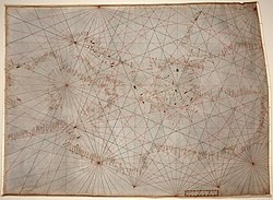
Historic cartography this time: it turns out the oldest map (or to be precise, nautical chart) at the
Library of Congress was available in high resolution digital form. JPEG2000 unfortunately, which makes this a little less than ideal technically but still very high resolution and a substantial
199:- Poor photographic quality with obvious jpeg artifacts. It's not enough to be the earliest extant portolan chart in the Library of Congress to become an FP. I can't understand this talk about restoration. This is a photo of a manuscript, not a scan of a print! --
168:
Looks close enough to standard of other map scans of this type to me. Artifacts are there, but only at a magnification well in excess of the original document size. Very interesting map, nice restoration.
271:
220:
on the JPEG2000 compression. This is a hand written map, that makes it a manuscript. These historic maps are really one of a kind. They are highly encyclopaedic. Thanks,
77:
261:
76:
had a lead image. They do now. Mediterranean and part of the Black Sea. Fourteenth century, second quarter. Ink on vellum. Restored version of
17:
247:
229:
208:
191:
177:
160:
143:
116:
266:
125:
131:
175:
33:
139:
128:
94:
73:
204:
170:
41:
243:
156:
225:
135:
52:
217:
200:
187:
90:
65:
48:
45:
255:
239:
216:
the compression ratio was 20 to 1 this is better then the 30 to 1 ratio indicated in
152:
221:
111:
86:
69:
236:
Promoted File:Mediterranean chart fourteenth century2.jpg
40:- The oldest original cartographic artifact in the
78:File:Mediterranean chart fourteenth century.jpg
8:
64:improvement over the previous lead image at
55:. Second quarter of the fourteenth century.
18:Knowledge (XXG):Featured picture candidates
124:. Jpeggy, and inferior scan to others in
272:Featured picture nominations/January 2009
32:
7:
185:A good restoration with strong EV.
28:Portolan chart of the Mediterranean
262:Ended featured picture nominations
24:
83:Articles this image appears in
1:
267:Featured picture nominations
248:06:28, 28 January 2009 (UTC)
230:17:48, 26 January 2009 (UTC)
209:23:43, 25 January 2009 (UTC)
192:17:56, 23 January 2009 (UTC)
178:01:48, 20 January 2009 (UTC)
161:17:14, 19 January 2009 (UTC)
144:14:41, 19 January 2009 (UTC)
117:03:24, 18 January 2009 (UTC)
288:
102:Anonymous, probably Genoan
68:. Surprisingly, neither
95:History of cartography
74:history of cartography
56:
36:
108:Support as nominator
42:Library of Congress
57:
53:Mediterranean Sea
279:
190:
114:
287:
286:
282:
281:
280:
278:
277:
276:
252:
251:
186:
112:
31:
22:
21:
20:
12:
11:
5:
285:
283:
275:
274:
269:
264:
254:
253:
233:
232:
211:
194:
180:
163:
146:
119:
104:
103:
100:
97:
91:Portolan chart
84:
81:
66:portolan chart
61:
49:nautical chart
30:
25:
23:
15:
14:
13:
10:
9:
6:
4:
3:
2:
284:
273:
270:
268:
265:
263:
260:
259:
257:
250:
249:
245:
241:
237:
231:
227:
223:
219:
215:
212:
210:
206:
202:
198:
195:
193:
189:
184:
181:
179:
176:
174:
173:
167:
164:
162:
158:
154:
150:
147:
145:
141:
137:
133:
130:
127:
123:
120:
118:
115:
109:
106:
105:
101:
98:
96:
92:
88:
85:
82:
79:
75:
71:
67:
62:
59:
58:
54:
50:
47:
43:
39:
35:
29:
26:
19:
235:
234:
213:
196:
182:
171:
165:
149:Weak support
148:
136:Spikebrennan
121:
107:
37:
27:
201:Alvesgaspar
87:Cartography
70:cartography
256:Categories
218:this paper
188:Elucidate
240:Wronkiew
153:ragesoss
46:portolan
38:Original
222:GerardM
214:Support
183:Support
166:Support
99:Creator
51:of the
197:Oppose
172:mikaul
122:Oppose
113:Durova
60:Reason
132:group
16:<
244:talk
226:talk
205:talk
157:talk
140:talk
129:peer
44:: a
134:.
126:its
72:or
258::
246:)
238:--
228:)
207:)
159:)
142:)
110:--
93:,
89:,
242:(
224:(
203:(
155:(
138:(
80:.
Text is available under the Creative Commons Attribution-ShareAlike License. Additional terms may apply.