322:
223:
289:
256:
329:
296:
263:
230:
2026:
24:
412:
of 38 m (125 ft). Its seclusion is due in part to its low profile and long approach walks. The East crag has a 'Wolf hole' at the base of the south-facing side, presumably how it originally gained the name. Wolfhole Crag marks the northwesternmost boundary of the civil parish of
444:. The buttresses contain a number of recorded rock climbs, including the two farthest "hard grit" routes (E7 & E6) from the road in the entire UK. Both climbs were ascended in 2001 by Neil Kershaw and Greg Chapman. It is quite possible to not see another human being all day there.
133:
321:
288:
222:
1276:
511:
372:
2067:
2096:
1269:
255:
2086:
1217:
504:
178:
1262:
2101:
2091:
2060:
497:
107:
1896:
1151:
440:. The summit consists of two large (10m high) buttresses of gritstone, some unusually shaped waist-high rocks, and the usual
45:
41:
88:
366:
60:
2053:
799:
171:
67:
1019:
753:
1917:
1187:
74:
1866:
1840:
1779:
1568:
1105:
804:
638:
558:
34:
1835:
1814:
1774:
1744:
1604:
1563:
1528:
1508:
1014:
1004:
994:
748:
723:
573:
409:
161:
56:
1694:
1639:
1463:
1383:
1305:
954:
934:
874:
814:
688:
668:
464:
1876:
1764:
1759:
1689:
1674:
1669:
1644:
1609:
1553:
1548:
1458:
1453:
1398:
1388:
1343:
1131:
844:
834:
648:
593:
437:
138:
1719:
1664:
1483:
1433:
1348:
1024:
864:
824:
758:
608:
436:
meets this halfway. A final path comes from the northeast from the Hornby Road in the direction to
418:
414:
2025:
1927:
1754:
1739:
1624:
1533:
1443:
989:
924:
899:
869:
829:
718:
658:
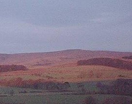
633:
563:
433:
1819:
1769:
1679:
1654:
1558:
1448:
1413:
1286:
1084:
1064:
939:
819:
673:
583:
578:
401:
358:
1978:
1794:
1784:
1684:
1583:
1573:
1488:
1074:
1069:
964:
783:
693:
489:
429:
132:
81:
1999:
1932:
1789:
1749:
1614:
1578:
1518:
1368:
1358:
1333:
1207:
1126:
849:
598:
385:
380:
1886:
425:
2037:
1937:
1714:
1588:
1177:
1136:
1121:
884:
2080:
1957:
1952:
1724:
1704:
1493:
1473:
1468:
1254:
1182:
1172:
1059:
909:
809:
613:
568:
521:
1922:
1856:
1423:
1408:
1403:
1229:
1224:
1212:
1197:
1192:
889:
653:
623:
1891:
1734:
1709:
1659:
1543:
1478:
1428:
1353:
1239:
1146:
944:
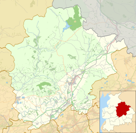
678:
23:
2033:
1994:
1962:
1947:
1942:
1629:
1538:
1378:
1328:
1234:
1202:
1100:
1079:
969:
959:
904:
894:
698:
628:
441:
405:
193:
180:
2004:
1881:
1871:
1861:
1729:
1699:
1649:
1634:
1503:
1498:
1393:
1363:
1338:
1310:
1300:
1029:
999:
984:
974:
949:
914:
854:
768:
763:
728:
713:
703:
683:
540:
535:
859:
839:
603:
588:
1619:
1523:
1513:
1438:
1418:
1373:
1141:
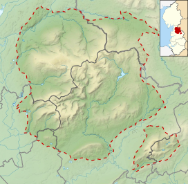
1039:
1034:
1009:
919:
879:
778:
773:
743:
738:
618:
979:
929:
708:
663:
643:
151:
408:, England. It has an elevation of 527 m (1,729 ft) and a
733:
1258:
493:
17:
2041:
1987:
1971:
1910:
1849:
1828:
1803:
1597:
1319:
1293:
1165:
1114:
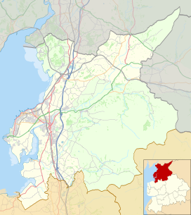
1093:
1048:
792:
549:
528:
379:
365:
354:
209:
170:
160:
150:
145:
125:
48:. Unsourced material may be challenged and removed.
428:in the west which is fraught with bogs. Another
400:is an isolated and seldom-visited hill in the
2061:
1270:
505:
8:
137:Wolfhole Crag in the distance as seen from
2068:
2054:
1807:
1277:
1263:
1255:
1052:
512:
498:
490:
417:, the historic Forest of Bowland, and the
311:Show map of the City of Lancaster district
308:Location in the City of Lancaster district
122:
108:Learn how and when to remove this message
344:Show map of the Borough of Ribble Valley
453:
459:
457:
471:. Database of British and Irish Hills
328:
295:
262:
229:
7:
2022:
2020:
46:adding citations to reliable sources
2097:Geography of the City of Lancaster
14:
341:Location in Ribble Valley Borough
245:Show map of the Forest of Bowland
242:Location in the Forest of Bowland
2024:
327:
320:
294:
287:
261:
254:
228:
221:
131:
22:
33:needs additional citations for
2087:Hills of the Forest of Bowland
1:
120:Mountain in northwest England
2040:. You can help Knowledge by
800:Aighton, Bailey and Chaigley
424:A long path approaches from
1815:Arnside and Silverdale AONB
2118:
2102:Lancashire geography stubs
2092:Geography of Ribble Valley
2019:
156:527 m (1,729 ft)
1810:
1055:
214:
130:
522:Borough of Ribble Valley
1841:Lancashire Witches Walk
1106:Lancashire Witches Walk
1060:Centre of Great Britain
166:38 m (125 ft)
2036:location article is a
1836:Lancashire Coastal Way
1820:Forest of Bowland AONB
1605:Aldcliffe-with-Stodday
1005:Thornley-with-Wheatley
278:Show map of Lancashire
275:Location in Lancashire
1640:Caton-with-Littledale
815:Billington and Langho
1877:Hawthornthwaite Fell
1690:Melling-with-Wrayton
1675:Hornby-with-Farleton
1670:Heaton-with-Oxcliffe
1610:Arkholme-with-Cawood
1132:Hawthornthwaite Fell
835:Bowland-with-Leagram
194:54.01667°N 2.56616°W
139:Hawthornthwaite fell
42:improve this article
1665:Halton-with-Aughton
825:Bowland Forest High
419:Lordship of Bowland
415:Bowland Forest High
190: /
1625:Burrow-with-Burrow
1294:Cities & towns
830:Bowland Forest Low
199:54.01667; -2.56616
146:Highest point
2049:
2048:
2017:
2016:
2013:
2012:
1287:City of Lancaster
1285:Geography of the
1252:
1251:
1248:
1247:
1085:Trough of Bowland
1065:Forest of Bowland
820:Bolton-by-Bowland
584:Brockhall Village
579:Bolton-by-Bowland
520:Geography of the
402:Forest of Bowland
395:
394:
359:Forest of Bowland
118:
117:
110:
92:
2109:
2070:
2063:
2056:
2028:
2021:
1808:
1795:Yealand Redmayne
1785:Wray-with-Botton
1584:Yealand Redmayne
1489:Poulton-le-Sands
1279:
1272:
1265:
1256:
1075:Stocks Reservoir
1070:Forest of Pendle
1053:
514:
507:
500:
491:
481:
480:
478:
476:
461:
375:
345:
331:
330:
324:
312:
298:
297:
291:
279:
265:
264:
258:
246:
232:
231:
225:
205:
204:
202:
201:
200:
195:
191:
188:
187:
186:
183:
135:
123:
113:
106:
102:
99:
93:
91:
50:
26:
18:
2117:
2116:
2112:
2111:
2110:
2108:
2107:
2106:
2077:
2076:
2075:
2074:
2018:
2009:
2000:Lancaster Canal
1988:Other waterways
1983:
1967:
1906:
1845:
1824:
1799:
1790:Yealand Conyers
1750:Slyne-with-Hest
1615:Bolton-le-Sands
1593:
1579:Yealand Conyers
1369:Bolton-le-Sands
1334:Abraham Heights
1321:
1315:
1289:
1283:
1253:
1244:
1208:Pendleton Brook
1161:
1127:Fair Snape Fell
1110:
1089:
1044:
850:Clayton-le-Dale
788:
599:Clayton-le-Dale
551:
545:
524:
518:
487:
485:
484:
474:
472:
465:"Wolfhole Crag"
463:
462:
455:
450:
371:
350:
349:
348:
347:
346:
343:
342:
339:
338:
337:
336:
332:
315:
314:
313:
310:
309:
306:
305:
304:
303:
299:
282:
281:
280:
277:
276:
273:
272:
271:
270:
266:
249:
248:
247:
244:
243:
240:
239:
238:
237:
233:
198:
196:
192:
189:
184:
181:
179:
177:
176:
141:
121:
114:
103:
97:
94:
57:"Wolfhole Crag"
51:
49:
39:
27:
12:
11:
5:
2115:
2113:
2105:
2104:
2099:
2094:
2089:
2079:
2078:
2073:
2072:
2065:
2058:
2050:
2047:
2046:
2029:
2015:
2014:
2011:
2010:
2008:
2007:
2002:
1997:
1991:
1989:
1985:
1984:
1982:
1981:
1975:
1973:
1972:River features
1969:
1968:
1966:
1965:
1960:
1955:
1950:
1945:
1940:
1935:
1930:
1925:
1920:
1914:
1912:
1908:
1907:
1905:
1904:
1899:
1894:
1889:
1884:
1879:
1874:
1869:
1864:
1859:
1853:
1851:
1847:
1846:
1844:
1843:
1838:
1832:
1830:
1826:
1825:
1823:
1822:
1817:
1811:
1805:
1801:
1800:
1798:
1797:
1792:
1787:
1782:
1777:
1772:
1767:
1762:
1757:
1752:
1747:
1742:
1737:
1732:
1727:
1722:
1717:
1715:Over Wyresdale
1712:
1707:
1702:
1697:
1692:
1687:
1682:
1677:
1672:
1667:
1662:
1657:
1652:
1647:
1642:
1637:
1632:
1627:
1622:
1617:
1612:
1607:
1601:
1599:
1595:
1594:
1592:
1591:
1589:Yealand Storrs
1586:
1581:
1576:
1571:
1566:
1561:
1556:
1554:Upper Thurnham
1551:
1546:
1541:
1536:
1531:
1526:
1521:
1516:
1511:
1506:
1501:
1496:
1491:
1486:
1481:
1476:
1471:
1466:
1461:
1456:
1454:Lower Thurnham
1451:
1446:
1441:
1436:
1431:
1426:
1421:
1416:
1411:
1406:
1401:
1396:
1391:
1386:
1381:
1376:
1371:
1366:
1361:
1356:
1351:
1346:
1341:
1336:
1331:
1325:
1323:
1317:
1316:
1314:
1313:
1308:
1303:
1297:
1295:
1291:
1290:
1284:
1282:
1281:
1274:
1267:
1259:
1250:
1249:
1246:
1245:
1243:
1242:
1237:
1232:
1227:
1222:
1221:
1220:
1210:
1205:
1200:
1195:
1190:
1185:
1180:
1178:Dinckley Brook
1175:
1169:
1167:
1163:
1162:
1160:
1159:
1154:
1149:
1144:
1139:
1137:Longridge Fell
1134:
1129:
1124:
1122:Easington Fell
1118:
1116:
1112:
1111:
1109:
1108:
1103:
1097:
1095:
1091:
1090:
1088:
1087:
1082:
1077:
1072:
1067:
1062:
1056:
1050:
1046:
1045:
1043:
1042:
1037:
1032:
1027:
1022:
1017:
1012:
1007:
1002:
997:
992:
987:
982:
977:
972:
967:
962:
957:
952:
947:
942:
937:
932:
927:
922:
917:
912:
907:
902:
897:
892:
887:
885:Gisburn Forest
882:
877:
872:
867:
862:
857:
852:
847:
842:
837:
832:
827:
822:
817:
812:
807:
802:
796:
794:
790:
789:
787:
786:
781:
776:
771:
766:
761:
756:
751:
746:
741:
736:
731:
726:
721:
716:
711:
706:
701:
696:
691:
686:
681:
676:
671:
666:
661:
656:
651:
646:
641:
636:
631:
626:
621:
616:
611:
606:
601:
596:
591:
586:
581:
576:
571:
566:
561:
555:
553:
547:
546:
544:
543:
538:
532:
530:
526:
525:
519:
517:
516:
509:
502:
494:
483:
482:
452:
451:
449:
446:
393:
392:
383:
377:
376:
369:
363:
362:
356:
352:
351:
340:
334:
333:
326:
325:
319:
318:
317:
316:
307:
301:
300:
293:
292:
286:
285:
284:
283:
274:
268:
267:
260:
259:
253:
252:
251:
250:
241:
235:
234:
227:
226:
220:
219:
218:
217:
216:
215:
212:
211:
207:
206:
174:
168:
167:
164:
158:
157:
154:
148:
147:
143:
142:
136:
128:
127:
119:
116:
115:
30:
28:
21:
13:
10:
9:
6:
4:
3:
2:
2114:
2103:
2100:
2098:
2095:
2093:
2090:
2088:
2085:
2084:
2082:
2071:
2066:
2064:
2059:
2057:
2052:
2051:
2045:
2043:
2039:
2035:
2030:
2027:
2023:
2006:
2003:
2001:
1998:
1996:
1993:
1992:
1990:
1986:
1980:
1979:Crook o' Lune
1977:
1976:
1974:
1970:
1964:
1961:
1959:
1956:
1954:
1951:
1949:
1946:
1944:
1941:
1939:
1936:
1934:
1931:
1929:
1926:
1924:
1921:
1919:
1916:
1915:
1913:
1909:
1903:
1902:Wolfhole Crag
1900:
1898:
1895:
1893:
1890:
1888:
1885:
1883:
1880:
1878:
1875:
1873:
1870:
1868:
1865:
1863:
1860:
1858:
1855:
1854:
1852:
1848:
1842:
1839:
1837:
1834:
1833:
1831:
1827:
1821:
1818:
1816:
1813:
1812:
1809:
1806:
1802:
1796:
1793:
1791:
1788:
1786:
1783:
1781:
1778:
1776:
1773:
1771:
1768:
1766:
1763:
1761:
1758:
1756:
1753:
1751:
1748:
1746:
1743:
1741:
1738:
1736:
1733:
1731:
1728:
1726:
1725:Priest Hutton
1723:
1721:
1718:
1716:
1713:
1711:
1708:
1706:
1705:Nether Kellet
1703:
1701:
1698:
1696:
1693:
1691:
1688:
1686:
1683:
1681:
1678:
1676:
1673:
1671:
1668:
1666:
1663:
1661:
1658:
1656:
1653:
1651:
1648:
1646:
1643:
1641:
1638:
1636:
1633:
1631:
1628:
1626:
1623:
1621:
1618:
1616:
1613:
1611:
1608:
1606:
1603:
1602:
1600:
1596:
1590:
1587:
1585:
1582:
1580:
1577:
1575:
1572:
1570:
1567:
1565:
1562:
1560:
1557:
1555:
1552:
1550:
1547:
1545:
1542:
1540:
1537:
1535:
1532:
1530:
1527:
1525:
1522:
1520:
1517:
1515:
1512:
1510:
1507:
1505:
1502:
1500:
1497:
1495:
1494:Priest Hutton
1492:
1490:
1487:
1485:
1482:
1480:
1477:
1475:
1474:Nether Kellet
1472:
1470:
1469:Nether Burrow
1467:
1465:
1462:
1460:
1457:
1455:
1452:
1450:
1447:
1445:
1442:
1440:
1437:
1435:
1432:
1430:
1427:
1425:
1422:
1420:
1417:
1415:
1412:
1410:
1407:
1405:
1402:
1400:
1397:
1395:
1392:
1390:
1387:
1385:
1382:
1380:
1377:
1375:
1372:
1370:
1367:
1365:
1362:
1360:
1357:
1355:
1352:
1350:
1347:
1345:
1342:
1340:
1337:
1335:
1332:
1330:
1327:
1326:
1324:
1322:& suburbs
1318:
1312:
1309:
1307:
1304:
1302:
1299:
1298:
1296:
1292:
1288:
1280:
1275:
1273:
1268:
1266:
1261:
1260:
1257:
1241:
1238:
1236:
1233:
1231:
1228:
1226:
1223:
1219:
1216:
1215:
1214:
1211:
1209:
1206:
1204:
1201:
1199:
1196:
1194:
1191:
1189:
1186:
1184:
1183:Mearley Brook
1181:
1179:
1176:
1174:
1173:Bashall Brook
1171:
1170:
1168:
1164:
1158:
1157:Wolfhole Crag
1155:
1153:
1150:
1148:
1145:
1143:
1140:
1138:
1135:
1133:
1130:
1128:
1125:
1123:
1120:
1119:
1117:
1113:
1107:
1104:
1102:
1099:
1098:
1096:
1092:
1086:
1083:
1081:
1078:
1076:
1073:
1071:
1068:
1066:
1063:
1061:
1058:
1057:
1054:
1051:
1047:
1041:
1038:
1036:
1033:
1031:
1028:
1026:
1023:
1021:
1020:West Bradford
1018:
1016:
1013:
1011:
1008:
1006:
1003:
1001:
998:
996:
993:
991:
988:
986:
983:
981:
978:
976:
973:
971:
968:
966:
963:
961:
958:
956:
953:
951:
948:
946:
943:
941:
938:
936:
933:
931:
928:
926:
923:
921:
918:
916:
913:
911:
910:Little Mitton
908:
906:
903:
901:
898:
896:
893:
891:
888:
886:
883:
881:
878:
876:
873:
871:
868:
866:
863:
861:
858:
856:
853:
851:
848:
846:
843:
841:
838:
836:
833:
831:
828:
826:
823:
821:
818:
816:
813:
811:
810:Bashall Eaves
808:
806:
803:
801:
798:
797:
795:
791:
785:
782:
780:
777:
775:
772:
770:
767:
765:
762:
760:
757:
755:
754:West Bradford
752:
750:
747:
745:
742:
740:
737:
735:
732:
730:
727:
725:
722:
720:
717:
715:
712:
710:
707:
705:
702:
700:
697:
695:
692:
690:
687:
685:
682:
680:
677:
675:
672:
670:
667:
665:
662:
660:
657:
655:
652:
650:
647:
645:
642:
640:
637:
635:
632:
630:
627:
625:
622:
620:
617:
615:
614:Dunsop Bridge
612:
610:
607:
605:
602:
600:
597:
595:
592:
590:
587:
585:
582:
580:
577:
575:
572:
570:
569:Bashall Eaves
567:
565:
562:
560:
557:
556:
554:
552:& suburbs
548:
542:
539:
537:
534:
533:
531:
527:
523:
515:
510:
508:
503:
501:
496:
495:
492:
488:
470:
466:
460:
458:
454:
447:
445:
443:
439:
435:
431:
427:
422:
420:
416:
411:
407:
403:
399:
398:Wolfhole Crag
390:
387:
384:
382:
378:
374:
370:
368:
364:
360:
357:
353:
335:Wolfhole Crag
323:
302:Wolfhole Crag
290:
269:Wolfhole Crag
257:
236:Wolfhole Crag
224:
213:
208:
203:
175:
173:
169:
165:
163:
159:
155:
153:
149:
144:
140:
134:
129:
126:Wolfhole Crag
124:
112:
109:
101:
98:February 2024
90:
87:
83:
80:
76:
73:
69:
66:
62:
59: –
58:
54:
53:Find sources:
47:
43:
37:
36:
31:This article
29:
25:
20:
19:
16:
2042:expanding it
2031:
1901:
1887:Ward's Stone
1857:Clougha Pike
1409:Dolphinholme
1404:Cowan Bridge
1399:Conder Green
1230:Skirden Beck
1225:Sabden Brook
1156:
890:Great Mitton
654:Mellor Brook
624:Great Mitton
486:
473:. Retrieved
469:Hill Bagging
468:
426:Ward's Stone
423:
397:
396:
388:
104:
95:
85:
78:
71:
64:
52:
40:Please help
35:verification
32:
15:
1892:Warton Crag
1780:Whittington
1735:Roeburndale
1710:Over Kellet
1660:Gressingham
1569:Whittington
1544:Torrisholme
1479:Over Kellet
1429:Gressingham
1354:Bank Houses
1240:Stydd Brook
1218:tributaries
1147:Pendle Hill
945:Osbaldeston
805:Balderstone
679:Osbaldeston
639:Hurst Green
559:Balderstone
389:Landrangers
197: /
172:Coordinates
2081:Categories
2034:Lancashire
1995:Artle Beck
1897:White Hill
1867:Green Hill
1804:Topography
1775:Wennington
1745:Silverdale
1630:Cantsfield
1564:Wennington
1539:Tewitfield
1529:Sunderland
1509:Silverdale
1379:Cantsfield
1329:Abbeystead
1235:Stock Beck
1152:White Hill
1101:Ribble Way
1080:Stonyhurst
1049:Topography
1015:Waddington
995:Simonstone
970:Ribchester
960:Ramsgreave
905:Hothersall
895:Grindleton
749:Waddington
724:Simonstone
699:Ribchester
629:Grindleton
574:Billington
475:2 February
448:References
442:trig point
438:White Hill
432:path from
410:prominence
406:Lancashire
182:54°01′00″N
162:Prominence
68:newspapers
2005:Leck Beck
1933:Grizedale
1882:Leck Fell
1872:Grit Fell
1862:Gragareth
1829:Footpaths
1740:Scotforth
1730:Quernmore
1700:Morecambe
1695:Middleton
1650:Cockerham
1645:Claughton
1635:Carnforth
1504:Scotforth
1499:Quernmore
1464:Middleton
1394:Cockerham
1389:Claughton
1364:Bay Horse
1339:Aldcliffe
1311:Morecambe
1306:Lancaster
1301:Carnforth
1166:Waterways
1094:Footpaths
1030:Wilpshire
1000:Slaidburn
985:Salesbury
975:Rimington
955:Pendleton
950:Paythorne
935:Newsholme
915:Longridge
875:Easington
855:Clitheroe
769:Wilpshire
764:Whitewell
729:Slaidburn
714:Salesbury
704:Rimington
689:Pendleton
684:Paythorne
669:Newsholme
541:Longridge
536:Clitheroe
434:Tarnbrook
361:, England
210:Geography
185:2°33′58″W
152:Elevation
1938:Hindburn
1765:Tunstall
1760:Thurnham
1598:Parishes
1549:Tunstall
1344:Arkholme
1320:Villages
1213:R Ribble
1198:R Hodder
1193:R Dunsop
1188:R Calder
860:Dinckley
845:Chipping
840:Chatburn
793:Parishes
649:Low Moor
604:Dinckley
594:Chipping
589:Chatburn
550:Villages
391:102, 103
381:Topo map
373:SD630580
355:Location
1958:Wenning
1953:Roeburn
1720:Overton
1620:Borwick
1524:Stodday
1514:Skerton
1484:Overton
1459:Melling
1439:Heysham
1424:Glasson
1419:Galgate
1374:Borwick
1349:Aughton
1142:Parlick
1040:Worston
1035:Wiswell
1025:Whalley
1010:Twiston
920:Mearley
880:Gisburn
865:Downham
779:Worston
774:Wiswell
759:Whalley
744:Twiston
739:Tosside
619:Gisburn
609:Downham
367:OS grid
82:scholar
1923:Conder
1918:Cocker
1911:Rivers
1770:Warton
1755:Tatham
1559:Warton
1534:Tatham
1444:Hornby
1434:Halton
1203:R Loud
990:Sawley
980:Sabden
940:Newton
930:Middop
925:Mellor
900:Horton
870:Dutton
719:Sawley
709:Sabden
674:Newton
664:Middop
659:Mellor
644:Langho
634:Horton
564:Barrow
430:tarmac
84:
77:
70:
63:
55:
2032:This
1928:Greta
1850:Hills
1680:Ireby
1655:Ellel
1519:Slyne
1449:Ireby
1414:Ellel
1384:Caton
1115:Hills
734:Stydd
529:Towns
89:JSTOR
75:books
2038:stub
1963:Wyre
1948:Lune
1943:Keer
1685:Leck
1574:Wray
1359:Bare
965:Read
784:York
694:Read
477:2024
61:news
404:in
44:by
2083::
467:.
456:^
421:.
386:OS
2069:e
2062:t
2055:v
2044:.
1278:e
1271:t
1264:v
513:e
506:t
499:v
479:.
111:)
105:(
100:)
96:(
86:·
79:·
72:·
65:·
38:.
Text is available under the Creative Commons Attribution-ShareAlike License. Additional terms may apply.