138:
131:
26:
297:
292:
282:
260:
302:
67:
130:
287:
60:
53:
231:
192:
188:
257:
215:
to the northeast. There are forests in the lower areas, the highest areas consist of dry grasslands.
196:
48:
222:, on the southeast side of the mountain, was named after the mountain. The nearest villages are
200:
264:
180:
151:
204:
168:
111:
25:
276:
227:
212:
199:
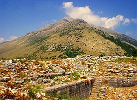
regional units. Its maximum elevation is 1,614 m. It is drained by the river
82:
69:
223:
219:
235:
208:
184:
38:
118:
103:
98:
59:
47:
37:
32:
18:
8:
179:) is a mountain in the southern part of the
207:to the west. The nearest mountains are the
15:
253:
251:
247:
298:Landforms of Ioannina (regional unit)
110:
7:
293:Landforms of Preveza (regional unit)
14:
283:Landforms of Arta (regional unit)
137:
136:
129:
24:
1:
203:to the east and by the river
187:. It covers the northeastern
303:Mountains of Epirus (region)
43:1,614 m (5,295 ft)
263:September 21, 2013, at the
54:List of mountains in Greece
319:
211:to the northwest and the
172:
123:
23:
234:to the northwest and
195:and the northwestern
83:39.39389°N 20.99194°E
112:[kseroˈvuni]
288:Mountains of Greece
218:The municipal unit
79: /
238:to the southwest.
230:to the northeast,
88:39.39389; 20.99194
33:Highest point
175:, also Ξηροβούνι
162:
161:
310:
267:
255:
174:
140:
139:
133:
114:
109:
94:
93:
91:
90:
89:
84:
80:
77:
76:
75:
72:
28:
16:
318:
317:
313:
312:
311:
309:
308:
307:
273:
272:
271:
270:
265:Wayback Machine
256:
249:
244:
191:, the southern
158:
157:
156:
155:
154:
148:
147:
146:
145:
141:
107:
87:
85:
81:
78:
73:
70:
68:
66:
65:
12:
11:
5:
316:
314:
306:
305:
300:
295:
290:
285:
275:
274:
269:
268:
258:Oreivatein.com
246:
245:
243:
240:
160:
159:
149:
143:
142:
135:
134:
128:
127:
126:
125:
124:
121:
120:
116:
115:
105:
101:
100:
96:
95:
63:
57:
56:
51:
45:
44:
41:
35:
34:
30:
29:
21:
20:
13:
10:
9:
6:
4:
3:
2:
315:
304:
301:
299:
296:
294:
291:
289:
286:
284:
281:
280:
278:
266:
262:
259:
254:
252:
248:
241:
239:
237:
233:
229:
226:to the east,
225:
221:
216:
214:
210:
206:
202:
198:
194:
190:
186:
182:
178:
170:
166:
153:
150:southcentral
132:
122:
117:
113:
106:
104:Pronunciation
102:
97:
92:
64:
62:
58:
55:
52:
50:
46:
42:
40:
36:
31:
27:
22:
17:
217:
176:
164:
163:
228:Platanoussa
86: /
61:Coordinates
277:Categories
242:References
213:Athamanika
74:20°59′31″E
71:39°23′38″N
220:Xirovouni
201:Arachthos
177:Xirovouni
173:Ξεροβούνι
165:Xerovouni
144:Xerovouni
119:Geography
39:Elevation
19:Xerovouni
261:Archived
232:Sklivani
193:Ioannina
183:region,
236:Anogeio
224:Dafnoti
209:Tomaros
189:Preveza
49:Listing
205:Louros
185:Greece
181:Epirus
152:Epirus
108:Greek:
99:Naming
169:Greek
197:Arta
279::
250:^
171::
167:(
Text is available under the Creative Commons Attribution-ShareAlike License. Additional terms may apply.