36:
248:. The main road north from Dushanbe follows the lower Yaghnob and the Fan Darya. Before the Soviets blasted a road through, the upper valley was protected by an almost impenetrable gorge, which accounts for the historical isolation of its population.
228:
merge. The
Yaghnob is mainly fed by glaciers and snow fields. The river flows from the east to the west, south of and parallel to the upper Zeravshan River, through the
82:
319:
324:
277:
20:
244:. It joins the east-flowing Iskander Darya to form the Fan Darya which flows north to join the Zeravshan at
245:
299:
237:
214:
168:
329:
233:
221:
229:
206:
186:
313:
194:
225:
198:
172:
63:
202:
51:
97:
84:
272:
210:
164:
68:
35:
293:
241:
220:
The source of the
Yaghnob is in the Matcha Mountains, where the
160:
155:
141:
133:
121:
113:
74:
62:
57:
47:
42:
28:
8:
257:
147:32.2 m/s (1,140 cu ft/s)
25:
267:
265:
263:
261:
232:, a remote location populated by the
7:
240:. The main village in the valley is
125:1,660 km (640 sq mi)
14:
213:, a major left tributary of the
34:
16:River in northwestern Tajikistan
76: • coordinates
1:
58:Physical characteristics
320:Tributaries of the Zeravshan
346:
143: • average
18:
292:Пагануцци, Н. В. (1968).
278:Great Soviet Encyclopedia
190:
151:
129:
33:
294:
117:116 km (72 mi)
236:speaking the eponymous
298:(in Russian). Moscow:
98:39.18861°N 68.53833°E
325:Rivers of Tajikistan
295:Фанские горы и Ягноб
205:. Together with the
19:For other uses, see
156:Basin features
94: /
300:Fizkultura i sport
103:39.18861; 68.53833
238:Yaghnobi language
179:
178:
337:
304:
303:
289:
283:
282:
269:
193:) is a river in
192:
144:
109:
108:
106:
105:
104:
99:
95:
92:
91:
90:
87:
38:
26:
345:
344:
340:
339:
338:
336:
335:
334:
310:
309:
308:
307:
296:
291:
290:
286:
271:
270:
259:
254:
234:Yaghnobi people
209:, it forms the
142:
102:
100:
96:
93:
88:
85:
83:
81:
80:
77:
24:
17:
12:
11:
5:
343:
341:
333:
332:
327:
322:
312:
311:
306:
305:
284:
256:
255:
253:
250:
230:Yaghnob Valley
207:Iskander Darya
177:
176:
162:
158:
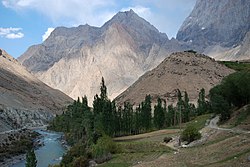
157:
153:
152:
149:
148:
145:
139:
138:
135:
131:
130:
127:
126:
123:
119:
118:
115:
111:
110:
78:
75:
72:
71:
66:
60:
59:
55:
54:
49:
45:
44:
40:
39:
31:
30:
15:
13:
10:
9:
6:
4:
3:
2:
342:
331:
328:
326:
323:
321:
318:
317:
315:
301:
297:
288:
285:
280:
279:
274:
268:
266:
264:
262:
258:
251:
249:
247:
243:
239:
235:
231:
227:
226:Gissar Ranges
223:
218:
216:
212:
208:
204:
200:
196:
195:Ayni District
188:
184:
174:
170:
166:
163:
159:
154:
150:
146:
140:
136:
132:
128:
124:
120:
116:
112:
107:
79:
73:
70:
67:
65:
61:
56:
53:
50:
46:
41:
37:
32:
27:
22:
287:
276:
219:
199:Sughd Region
182:
180:
161:Progression
101: /
314:Categories
252:References
203:Tajikistan
122:Basin size
89:68°32′18″E
86:39°11′19″N
52:Tajikistan
222:Zarafshan
215:Zeravshan
211:Fan Darya
169:Zeravshan
165:Fan Darya
134:Discharge
69:Fan Darya
224:and the
173:Qorakoʻl
43:Location
330:Yaghnob
273:"Ягноб"
183:Yaghnob
48:Country
29:Yaghnob
21:Yaghnob
137:
114:Length
242:Anzob
191:Яғноб
187:Tajik
175:oasis
64:Mouth
246:Ayni
181:The
197:of
316::
275:.
260:^
217:.
201:,
189::
171:→
167:→
302:.
281:.
185:(
23:.
Text is available under the Creative Commons Attribution-ShareAlike License. Additional terms may apply.