47:
719:
741:
64:, located under the foothills in the centre of the country. It is used by Israel for roughly 340 million cubic meters of water every year and for Palestine at a rate of approximately 20 million cubic meters a year,a rate that remains unchanged from the days when the West Bank was under Jordanian rule. The aquifer goes down to the
103:
The aquifer faces the problem of a gradual salinisation process, derived from the presence of a saline water body with a salinity level close to that of the
Mediterranean and located at the north-western edge of the aquifer. The freshwater and the saltwater are in direct contact, with no rock
35:, is the western and larger part of the Mountain Aquifer, which also contains the Eastern and the smaller North-Eastern (Mountain) Aquifers. The Mountain Aquifer and the Coastal Aquifer are the main aquifers shared by Israel in its pre-
318:
Amir Paster; Gedeon Dagan; Joseph
Guttman (30 May 2006). "The salt-water body in the Northern part of Yarkon-Taninim aquifer: Field data analysis, conceptual model and prediction".
204:
192:
104:
formations separating them, with just a relatively thin transition zone interposed between the freshwater body from the saltwater body beneath it.
371:
113:
615:
762:
450:
678:
465:
138:"Tension over equitable allocation of water: estimating renewable groundwater resources beneath the West Bank and Israel"
683:
430:
751:
480:
264:
223:
399:
610:
490:
364:
394:
32:
563:
553:
327:
276:
149:
698:
485:
470:
445:
221:'Harnessing International Law to Determine Israeli-Palestinian Water Rights: The Mountain Aquifer,'
92:
50:
205:
Yarkon-Taninim
Aquifer location map with the current natural groundwater table (after Dafny, 2009)
95:
was laid down by Samuel Mandel in 1961 and has since been contradicted by work published in 2001.
573:
404:
294:
165:
68:, beginning in the south and descending towards north-western Israel. The water recharges in the
647:
791:
722:
703:
657:
605:
357:
65:
693:
673:
589:
460:
440:
420:
335:
284:
157:
242:
652:
532:
475:
455:
435:
425:
220:
331:
280:
153:
568:
558:
46:
785:
495:
298:
169:
81:
688:
516:
137:
73:
339:
537:
36:
289:
77:
40:
88:
69:
58:
740:
136:
M. M. Mansour; D. W. Peach; A. G. Hughes; N. S. Robins (28 February 2012).
500:
380:
263:
D. Avisar; J. Kronfeld; J. Kolton; E. Rosenthal; G. Weinberger (2001).
61:
43:).It has been the main longterm reservoir of the Israeli water system.
161:
28:
45:
353:
193:
The Water Issue
Between Israel and the Palestinians: Main Facts
734:
349:
758:
765:
to it so that it can be listed with similar articles.
16:
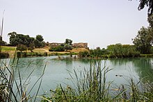
Western part of the Israel/Palestine mountain aquifer
666:
640:
624:
598:
582:
546:
525:
509:
413:
387:
142:Geological Society, London, Special Publications
365:
8:
91:region aquifer to the direct sources of the
226:, vol. 33, no.3 Summer 1993 pp.543-567,558.
215:
213:
84:on the coastal plain of the Mediterranean.
372:
358:
350:
275:(2B). The University of Arizona: 793–799.
265:"The Source of the Yarkon Springs, Israel"
288:
131:
129:
72:mountains and ends in the springs of the
236:
234:
232:
187:
185:
125:
39:borders, and Palestine (West Bank and
195:, February 2012. Accessed April 2019.
7:
750:needs additional or more specific
191:Water Authority, State of Israel:
14:
219:Eyal Benvenisti , Haim Gvirtzman
739:
718:
717:
114:Water Rights in Israel-Palestine
616:Nubian Sandstone Aquifer System
1:
679:Aquifers in the United States
340:10.1016/j.jhydrol.2005.08.018
684:Aquifer storage and recovery
431:Buried Valley Aquifer System
243:"The Yarkon-Taninim Aquifer"
808:
481:Santa Clara valley aquifer
712:
451:Kirkwood–Cohansey aquifer
290:10.1017/S0033822200041461
224:Natural Resources Journal
25:Western Mountain Aquifer
400:Laurentian River System
632:Yarkon-Taninim Aquifer
611:Lotikipi Basin Aquifer
491:Southern Hills Aquifer
207:. Accessed April 2019.
54:
21:Yarkon-Taninim Aquifer
395:Arkell Spring Grounds
87:The model adding the
49:
564:Great Artesian Basin
554:Botany Sands Aquifer
320:Journal of Hydrology
99:Salinisation problem
23:, also known as the
699:Sole Source Aquifer
486:Snake River Aquifer
471:San Diego Formation
446:Fox Hills Formation
332:2006JHyd..323..154P
281:2001Radcb..43..793A
154:2012GSLSP.362..355M
51:Rosh HaAyin springs
574:Yarragadee Aquifer
405:Oak Ridges Moraine
55:
780:
779:
763:adding categories
732:
731:
704:Surficial aquifer
658:Upper Rhine Plain
606:Bas Saharan Basin
66:Mediterranean Sea
799:
775:
772:
766:
743:
735:
721:
720:
694:Artesian aquifer
674:List of aquifers
667:Related articles
590:Waiwhetu Aquifer
461:Ogallala Aquifer
441:Floridan aquifer
421:Biscayne Aquifer
374:
367:
360:
351:
344:
343:
326:(1–4): 154–167.
315:
309:
308:
306:
305:
292:
260:
254:
253:
251:
250:
241:Aaron Scheiner.
238:
227:
217:
208:
202:
196:
189:
180:
179:
177:
176:
162:10.1144/SP362.20
133:
807:
806:
802:
801:
800:
798:
797:
796:
782:
781:
776:
770:
767:
756:
744:
733:
728:
708:
662:
653:Schwyll Aquifer
648:Alnarpsströmmen
636:
620:
594:
578:
542:
533:Guarani Aquifer
521:
505:
476:Sankoty Aquifer
456:Mahomet Aquifer
436:Edwards Aquifer
426:Bishop Subbasin
409:
383:
378:
348:
347:
317:
316:
312:
303:
301:
262:
261:
257:
248:
246:
240:
239:
230:
218:
211:
203:
199:
190:
183:
174:
172:
135:
134:
127:
122:
110:
101:
82:Taninim Springs
17:
12:
11:
5:
805:
803:
795:
794:
784:
783:
778:
777:
747:
745:
738:
730:
729:
727:
726:
713:
710:
709:
707:
706:
701:
696:
691:
686:
681:
676:
670:
668:
664:
663:
661:
660:
655:
650:
644:
642:
638:
637:
635:
634:
628:
626:
622:
621:
619:
618:
613:
608:
602:
600:
596:
595:
593:
592:
586:
584:
580:
579:
577:
576:
571:
569:Jandakot Mound
566:
561:
559:Gnangara Mound
556:
550:
548:
544:
543:
541:
540:
535:
529:
527:
523:
522:
520:
519:
513:
511:
507:
506:
504:
503:
498:
493:
488:
483:
478:
473:
468:
463:
458:
453:
448:
443:
438:
433:
428:
423:
417:
415:
411:
410:
408:
407:
402:
397:
391:
389:
385:
384:
379:
377:
376:
369:
362:
354:
346:
345:
310:
255:
228:
209:
197:
181:
148:(1): 355–361.
124:
123:
121:
118:
117:
116:
109:
106:
100:
97:
93:Yarkon springs
15:
13:
10:
9:
6:
4:
3:
2:
804:
793:
790:
789:
787:
774:
764:
760:
754:
753:
748:This article
746:
742:
737:
736:
725:
724:
715:
714:
711:
705:
702:
700:
697:
695:
692:
690:
687:
685:
682:
680:
677:
675:
672:
671:
669:
665:
659:
656:
654:
651:
649:
646:
645:
643:
639:
633:
630:
629:
627:
623:
617:
614:
612:
609:
607:
604:
603:
601:
597:
591:
588:
587:
585:
581:
575:
572:
570:
567:
565:
562:
560:
557:
555:
552:
551:
549:
545:
539:
536:
534:
531:
530:
528:
526:South America
524:
518:
515:
514:
512:
508:
502:
499:
497:
496:Turlock Basin
494:
492:
489:
487:
484:
482:
479:
477:
474:
472:
469:
467:
466:Permian Basin
464:
462:
459:
457:
454:
452:
449:
447:
444:
442:
439:
437:
434:
432:
429:
427:
424:
422:
419:
418:
416:
414:United States
412:
406:
403:
401:
398:
396:
393:
392:
390:
386:
382:
375:
370:
368:
363:
361:
356:
355:
352:
341:
337:
333:
329:
325:
321:
314:
311:
300:
296:
291:
286:
282:
278:
274:
270:
266:
259:
256:
244:
237:
235:
233:
229:
225:
222:
216:
214:
210:
206:
201:
198:
194:
188:
186:
182:
171:
167:
163:
159:
155:
151:
147:
143:
139:
132:
130:
126:
119:
115:
112:
111:
107:
105:
98:
96:
94:
90:
85:
83:
79:
75:
71:
67:
63:
60:
52:
48:
44:
42:
38:
34:
30:
26:
22:
768:
749:
716:
689:Aquifer test
631:
517:Lake Texcoco
323:
319:
313:
302:. Retrieved
272:
268:
258:
247:. Retrieved
200:
173:. Retrieved
145:
141:
102:
86:
74:Yarkon River
56:
24:
20:
18:
771:August 2024
625:Middle-East
583:New Zealand
538:Hamza River
269:Radiocarbon
245:. Prezi.com
752:categories
304:2019-05-01
249:2015-12-17
175:2019-05-01
120:References
89:Beer Sheva
78:Antipatris
41:Gaza Strip
547:Australia
299:132267856
170:129718279
70:West Bank
59:limestone
33:Palestine
792:Aquifers
786:Category
759:help out
723:Category
501:Wekepeke
381:Aquifers
108:See also
57:It is a
53:, Israel
757:Please
328:Bibcode
277:Bibcode
150:Bibcode
62:aquifer
641:Europe
599:Africa
510:Mexico
388:Canada
297:
168:
80:, and
29:Israel
295:S2CID
166:S2CID
37:1967
19:The
761:by
336:doi
324:323
285:doi
158:doi
146:362
76:at
27:of
788::
334:.
322:.
293:.
283:.
273:43
271:.
267:.
231:^
212:^
184:^
164:.
156:.
144:.
140:.
128:^
773:)
769:(
755:.
373:e
366:t
359:v
342:.
338::
330::
307:.
287::
279::
252:.
178:.
160::
152::
31:/
Text is available under the Creative Commons Attribution-ShareAlike License. Additional terms may apply.