974:
40:
913:
887:
515:
875:
55:
415:
Serena
Bianchetti, Michele Cataudella, Hans-Joachim Gehrke, [Brill's Companion to Ancient Geography: The Inhabited World in Greek and Roman Tradition (BRILL, 4 Dec 2015)
138:
958:
428:
Georgia L. IrbyGeorgia L. Irby, A Companion to
Science, Technology, and Medicine in Ancient Greece and Rome, 2 Volume Set (John Wiley & Sons, 2016) p 865.
399:), which also crosses the Themiscyra Plain (modern Çarşamba Plain), with its mouth about 40 km further east; the Thermodon is much smaller and clearer.
1011:
503:
481:
450:
1060:
341:
1055:
1050:
1045:
1040:
302:
951:
1004:
496:
416:
664:
944:
1065:
390:
997:
973:
669:
1035:
1030:
489:
558:
519:
707:
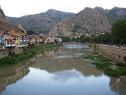
276:
222:
578:
717:
757:
385:
250:
697:
858:
649:
296:
752:
684:
981:
928:
920:
732:
727:
469:
370:
265:
246:
194:
39:
891:
588:
616:
553:
712:
702:
654:
608:
525:
292:
1024:
879:
802:
767:
742:
692:
543:
912:
853:
817:
792:
787:
782:
772:
548:
269:
563:
845:
807:
797:
747:
674:
659:
621:
583:
568:
437:
396:
287:
111:
17:
473:
835:
777:
762:
722:
631:
438:
Phytoplankton and seasonal variations of the River Yeşilırmak, Amasya, Turkey
356:
343:
317:
304:
153:
140:
825:
593:
535:
378:
254:
737:
598:
644:
639:
331:
54:
924:
830:
514:
374:
335:
282:
258:
242:
230:
73:
45:
238:
234:
485:
461:
Tønnes Bekker-Nielsen, Marit Jensen, "Two Pontic Rivers",
395:, the Iris is often confused with the Thermodon (modern
985:
932:
844:
816:
683:
630:
607:
534:
179:
169:
130:
120:
110:
96:
88:
79:
69:
64:
32:
980:This article related to a river in Turkey is a
1005:
952:
497:
8:
202:
1012:
998:
959:
945:
504:
490:
482:
53:
408:
377:(Amasya) before reaching the valley of
29:
7:
970:
968:
909:
907:
984:. You can help Knowledge (XXG) by
931:. You can help Knowledge (XXG) by
25:
261:after 418 km (260 mi).
1061:Black Sea Region geography stubs
972:
911:
886:
885:
873:
513:
291:describes it as flowing through
38:
338:) before receiving the waters (
233:. From its source northeast of
132: • coordinates
1:
80:Physical characteristics
1056:Landforms of Samsun Province
1051:Landforms of Amasya Province
264:Its tributaries include the
171: • elevation
1046:Landforms of Tokat Province
1041:Landforms of Sivas Province
463:Cedrus: The Journal of MCRI
122: • location
98: • location
1082:
967:
906:
474:10.13113/CEDRUS.2015011411
229:), is a river in northern
226:
867:
357:40.5615797°N 35.7595217°E
268:(ancient Scylax) and the
183:418 km (260 mi)
106:
84:
52:
37:
650:Karamenderes (Scamander)
318:40.2947808°N 36.296736°E
27:River in northern Turkey
373:, then flowing through
279:in the 1st century BC.
362:40.5615797; 35.7595217
198:
919:This article about a
323:40.2947808; 36.296736
59:Map of the Yeşilırmak
386:Dionysius Periegetes
277:Menippus of Pergamon
275:It was mentioned by
175:0 m (0 ft)
44:Yeşilırmak River in
353: /
314: /
154:41.3816°N 36.6603°E
150: /
1066:Turkey river stubs
559:Kızılırmak (Halys)
468::231-2142 (2015),
993:
992:
940:
939:
901:
900:
880:Turkey portal
826:Fırat (Euphrates)
768:Mezitli (Liparis)
685:Mediterranean Sea
334:(probably modern
272:(ancient Lycus).
187:
186:
16:(Redirected from
1073:
1036:Black Sea Region
1031:Rivers of Turkey
1014:
1007:
1000:
976:
969:
961:
954:
947:
921:Black Sea Region
915:
908:
889:
888:
878:
877:
876:
622:Susurluk (Simav)
529:
528:
520:Rivers of Turkey
518:
517:
506:
499:
492:
483:
476:
459:
453:
447:
441:
435:
429:
426:
420:
413:
368:
367:
365:
364:
363:
358:
354:
351:
350:
349:
346:
329:
328:
326:
325:
324:
319:
315:
312:
311:
310:
307:
247:Pontic Mountains
237:, it flows past
228:
217:), known as the
216:
213:
210:
207:
204:
165:
164:
162:
161:
160:
159:41.3816; 36.6603
155:
151:
148:
147:
146:
143:
99:
57:
42:
33:Yeşilırmak River
30:
21:
18:Yeşilırmak River
1081:
1080:
1076:
1075:
1074:
1072:
1071:
1070:
1021:
1020:
1019:
1018:
966:
965:
904:
902:
897:
874:
872:
863:
840:
812:
783:Berdan (Tarsus)
679:
640:Meriç (Maritsa)
626:
603:
530:
523:
522:
512:
510:
480:
479:
460:
456:
449:Strabo 12:3:15
448:
444:
436:
432:
427:
423:
414:
410:
405:
361:
359:
355:
352:
347:
344:
342:
340:
339:
322:
320:
316:
313:
308:
305:
303:
301:
300:
295:, the plain of
253:, reaching the
214:
211:
208:
205:
172:
158:
156:
152:
149:
144:
141:
139:
137:
136:
133:
123:
97:
60:
48:
28:
23:
22:
15:
12:
11:
5:
1079:
1077:
1069:
1068:
1063:
1058:
1053:
1048:
1043:
1038:
1033:
1023:
1022:
1017:
1016:
1009:
1002:
994:
991:
990:
977:
964:
963:
956:
949:
941:
938:
937:
927:location is a
916:
899:
898:
896:
895:
883:
868:
865:
864:
862:
861:
856:
850:
848:
842:
841:
839:
838:
833:
831:Dicle (Tigris)
828:
822:
820:
814:
813:
811:
810:
805:
800:
795:
790:
785:
780:
775:
773:Efrenk (Müftü)
770:
765:
760:
755:
750:
748:Alata (Sorgun)
745:
740:
735:
730:
725:
720:
715:
710:
705:
700:
695:
689:
687:
681:
680:
678:
677:
672:
670:Büyük Menderes
667:
665:Küçük Menderes
662:
657:
652:
647:
642:
636:
634:
628:
627:
625:
624:
619:
613:
611:
605:
604:
602:
601:
596:
591:
586:
581:
576:
571:
566:
561:
556:
551:
546:
540:
538:
532:
531:
526:drainage basin
511:
509:
508:
501:
494:
486:
478:
477:
454:
442:
430:
421:
407:
406:
404:
401:
384:Starting with
293:Comana Pontica
251:Çarşamba Plain
245:, crosses the
221:in antiquity (
185:
184:
181:
177:
176:
173:
170:
167:
166:
134:
131:
128:
127:
124:
121:
118:
117:
114:
108:
107:
104:
103:
100:
94:
93:
90:
86:
85:
82:
81:
77:
76:
71:
67:
66:
62:
61:
58:
50:
49:
43:
35:
34:
26:
24:
14:
13:
10:
9:
6:
4:
3:
2:
1078:
1067:
1064:
1062:
1059:
1057:
1054:
1052:
1049:
1047:
1044:
1042:
1039:
1037:
1034:
1032:
1029:
1028:
1026:
1015:
1010:
1008:
1003:
1001:
996:
995:
989:
987:
983:
978:
975:
971:
962:
957:
955:
950:
948:
943:
942:
936:
934:
930:
926:
922:
917:
914:
910:
905:
894:
893:
884:
882:
881:
870:
869:
866:
860:
857:
855:
852:
851:
849:
847:
843:
837:
834:
832:
829:
827:
824:
823:
821:
819:
815:
809:
806:
804:
803:Asi (Orontes)
801:
799:
796:
794:
791:
789:
786:
784:
781:
779:
776:
774:
771:
769:
766:
764:
761:
759:
756:
754:
751:
749:
746:
744:
741:
739:
736:
734:
731:
729:
726:
724:
721:
719:
716:
714:
711:
709:
706:
704:
701:
699:
696:
694:
691:
690:
688:
686:
682:
676:
673:
671:
668:
666:
663:
661:
658:
656:
653:
651:
648:
646:
643:
641:
638:
637:
635:
633:
629:
623:
620:
618:
615:
614:
612:
610:
606:
600:
597:
595:
592:
590:
587:
585:
582:
580:
577:
575:
572:
570:
567:
565:
562:
560:
557:
555:
552:
550:
547:
545:
542:
541:
539:
537:
533:
527:
521:
516:
507:
502:
500:
495:
493:
488:
487:
484:
475:
471:
467:
464:
458:
455:
452:
446:
443:
439:
434:
431:
425:
422:
418:
412:
409:
402:
400:
398:
394:
392:
387:
382:
380:
376:
372:
366:
337:
333:
327:
298:
294:
290:
289:
284:
280:
278:
273:
271:
267:
262:
260:
256:
252:
248:
244:
240:
236:
232:
224:
223:Ancient Greek
220:
200:
196:
192:
182:
178:
174:
168:
163:
135:
129:
125:
119:
115:
113:
109:
105:
101:
95:
91:
87:
83:
78:
75:
72:
68:
63:
56:
51:
47:
41:
36:
31:
19:
986:expanding it
979:
933:expanding it
918:
903:
890:
871:
818:Persian Gulf
573:
465:
462:
457:
445:
440:(9 May 2003)
433:
424:
411:
393:of the World
389:
383:
286:
281:
274:
263:
218:
190:
188:
758:Karacaoğlan
360: /
321: /
297:Dazimonitis
288:Geographica
212:green river
157: /
1025:Categories
574:Yeşilırmak
451:at Perseus
391:Periegesis
348:35°45′34″E
345:40°33′42″N
309:36°17′48″E
306:40°17′41″N
299:(Kaşova) (
199:Yeşilırmak
191:Yeşilırmak
145:36°39′37″E
142:41°22′54″N
594:Kara Dere
579:Yağlıdere
536:Black Sea
388:, in his
379:Phanaroea
369:) of the
255:Black Sea
126:Black Sea
892:Category
808:Deli Çay
713:Kaledran
708:Köprüçay
703:Manavgat
655:Bakırçay
589:Gelevara
257:east of
249:and the
65:Location
846:Caspian
778:Deliçay
743:Limonlu
733:Babadıl
728:Soğuksu
609:Marmara
544:Sakarya
375:Amaseia
332:Gaziura
330:), and
266:Çekerek
206:
195:Turkish
70:Country
925:Turkey
793:Ceyhan
788:Seyhan
718:Dragon
632:Aegean
554:Bartın
549:Filyos
371:Scylax
336:Turhal
283:Strabo
270:Kelkit
259:Samsun
243:Amasya
231:Turkey
180:Length
116:
92:
89:Source
74:Turkey
46:Amasya
836:Hezil
798:Payas
753:Tömük
738:Göksu
675:Azmak
660:Gediz
645:Tunca
599:Çoruh
569:Terme
417:p 263
403:Notes
397:Terme
239:Tokat
235:Sivas
112:Mouth
102:Sivas
982:stub
929:stub
859:Kura
854:Aras
763:Tece
723:Sini
698:Aksu
693:Eşen
617:Biga
584:Aksu
241:and
227:Ἶρις
219:Iris
203:lit.
189:The
923:of
564:Gök
524:by
470:doi
285:'s
1027::
381:.
225::
201:,
197::
1013:e
1006:t
999:v
988:.
960:e
953:t
946:v
935:.
505:e
498:t
491:v
472::
466:3
419:.
215:'
209:'
193:(
20:)
Text is available under the Creative Commons Attribution-ShareAlike License. Additional terms may apply.