156:
802:
26:
197:
There is a signed trailhead from
Chambers Road and an approximately 2.3 mile trail (gaining 1500 feet in elevation) leads to the summit. There are also side trails that lead to neighboring Pink Mountain.
395:
236:
warrior Sautee. When their love was forbidden by their tribal elders, a war party followed the eloping lovers and threw Sautee off the mountain, with
Nacoochee then jumping to her death, a
867:
843:
388:
872:
709:
877:
862:
381:
404:
882:
756:
480:
58:
229:
836:
761:
175:
336:
242:. Although he did not invent the legend, George Williams, the son of one of the original white settlers, popularized it in his 1871
274:
326:
829:
114:
435:
610:
51:
555:
355:
673:
658:
495:
490:
221:
155:
734:
600:
430:
262:
704:
590:
580:
535:
668:
653:
623:
425:
361:
225:
127:
809:
98:
595:
510:
412:
179:
102:
766:
714:
300:
678:
540:
520:
475:
470:
206:
183:
801:
751:
729:
719:
628:
575:
545:
460:
420:
332:
191:
813:
367:
724:
648:
633:
525:
455:
771:
746:
739:
699:
694:
109:
238:
781:
776:
663:
643:
618:
505:
485:
465:
445:
440:
187:
25:
856:
560:
550:
214:
210:
202:
638:
500:
232:
legend about a beautiful
Cherokee maiden named Nacoochee who fell in love with the
142:
565:
530:
515:
450:
73:
60:
570:
233:
217:
on Yonah
Mountain. It has been a popular training ground for rock climbers.
263:
U.S. Geological Survey
Geographic Names Information System: Yonah Mountain
373:
41:
154:
377:
328:
On Zion's Mount: Mormons, Indians, and the
American Landscape
817:
687:
609:
411:
141:
136:
126:
121:
108:
94:
89:
50:
40:
35:
18:
837:
389:
182:, United States. It is between the cities of
8:
244:Sketches of Travel in the Old and New World
844:
830:
396:
382:
374:
15:
331:. Harvard University Press. p. 313.
868:Protected areas of White County, Georgia
255:
174:") is a mountain ridge located in the
7:
873:Chattahoochee-Oconee National Forest
798:
796:
301:"The Legend of Sautee And Nacoochee"
279:Calhoun Times and Gordon County News
176:Chattahoochee-Oconee National Forest
201:The 5th Ranger Training Battalion,
878:Mountains of White County, Georgia
816:. You can help Knowledge (XXG) by
228:, Yonah Mountain is the site of a
14:
863:Mountains of Georgia (U.S. state)
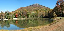
159:Yonah Mountain from Chambers Lake
800:
24:
1:
883:North Georgia geography stubs
757:Pine Mountain (Bartow County)
281:. August 29, 1990. p. 64
812:state location article is a
356:USDA Mount Yonah Trail Head
762:Pine Mountain (Cobb County)
170:" or, by older Georgians, "
899:
795:
166:(commonly referred to as "
46:3,166 ft (965 m)
30:Yonah Mountain in summer.
23:
735:Little Kennesaw Mountain
203:Ranger Training Brigade
426:Big John Dick Mountain
325:Farmer, Jared (2008).
160:
810:White County, Georgia
362:Yonah Mountain Trail
158:
74:34.63750°N 83.71361°W
511:Horsetrough Mountain
413:Blue Ridge Mountains
405:Mountains of Georgia
767:Pine Mountain Range
715:Chenocetah Mountain
436:Black Rock Mountain
79:34.63750; -83.71361
70: /
710:Blackjack Mountain
679:White Oak Mountain
541:Slaughter Mountain
521:Levelland Mountain
471:Double Spring Knob
275:"The Names Stayed"
207:United States Army
161:
36:Highest point
825:
824:
790:
789:
752:Pine Log Mountain
730:Kennesaw Mountain
629:Horseleg Mountain
576:Screamer Mountain
546:Springer Mountain
461:Currahee Mountain
421:Big Bald Mountain
153:
152:
890:
846:
839:
832:
804:
797:
649:Old Shorter Hill
634:Lookout Mountain
611:Ridge-and-Valley
556:Wildcat Mountain
526:Mount Oglethorpe
456:Cowrock Mountain
398:
391:
384:
375:
343:
342:
322:
316:
315:
313:
312:
305:Southern Pinning
297:
291:
290:
288:
286:
271:
265:
260:
222:Lookout Mountain
190:. Yonah is the
145:
85:
84:
82:
81:
80:
75:
71:
68:
67:
66:
63:
28:
16:
898:
897:
893:
892:
891:
889:
888:
887:
853:
852:
851:
850:
793:
791:
786:
772:Sawnee Mountain
747:Panola Mountain
740:Mount Wilkinson
700:Arabia Mountain
695:Alcovy Mountain
683:
674:Turkey Mountain
659:Pigeon Mountain
605:
496:Grassy Mountain
491:Glassy Mountain
407:
402:
352:
347:
346:
339:
324:
323:
319:
310:
308:
299:
298:
294:
284:
282:
273:
272:
268:
261:
257:
252:
230:Native American
194:word for Bear.
143:
78:
76:
72:
69:
64:
61:
59:
57:
56:
31:
12:
11:
5:
896:
894:
886:
885:
880:
875:
870:
865:
855:
854:
849:
848:
841:
834:
826:
823:
822:
805:
788:
787:
785:
784:
782:Sweat Mountain
779:
777:Stone Mountain
774:
769:
764:
759:
754:
749:
743:
742:
737:
732:
727:
722:
720:Dowdell's Knob
717:
712:
707:
702:
697:
691:
689:
685:
684:
682:
681:
676:
671:
666:
664:Snodgrass Hill
661:
656:
651:
646:
644:Johns Mountain
641:
636:
631:
626:
621:
619:Baugh Mountain
615:
613:
607:
606:
604:
603:
601:Rocky Mountain
598:
593:
588:
586:Yonah Mountain
583:
578:
573:
568:
563:
558:
553:
548:
543:
538:
533:
528:
523:
518:
513:
508:
506:Hightower Bald
503:
498:
493:
488:
486:Glade Mountain
483:
478:
473:
468:
463:
458:
453:
448:
446:Brasstown Bald
443:
441:Blood Mountain
438:
433:
431:Black Mountain
428:
423:
417:
415:
409:
408:
403:
401:
400:
393:
386:
378:
372:
371:
365:
359:
351:
350:External links
348:
345:
344:
338:978-0674027671
337:
317:
292:
266:
254:
253:
251:
248:
211:Mountain Phase
164:Yonah Mountain
151:
150:
147:
139:
138:
134:
133:
130:
124:
123:
119:
118:
112:
106:
105:
96:
92:
91:
87:
86:
54:
48:
47:
44:
38:
37:
33:
32:
29:
21:
20:
19:Yonah Mountain
13:
10:
9:
6:
4:
3:
2:
895:
884:
881:
879:
876:
874:
871:
869:
866:
864:
861:
860:
858:
847:
842:
840:
835:
833:
828:
827:
821:
819:
815:
811:
806:
803:
799:
794:
783:
780:
778:
775:
773:
770:
768:
765:
763:
760:
758:
755:
753:
750:
748:
745:
744:
741:
738:
736:
733:
731:
728:
726:
725:Heggie's Rock
723:
721:
718:
716:
713:
711:
708:
706:
705:Bear Mountain
703:
701:
698:
696:
693:
692:
690:
686:
680:
677:
675:
672:
670:
667:
665:
662:
660:
657:
655:
652:
650:
647:
645:
642:
640:
637:
635:
632:
630:
627:
625:
622:
620:
617:
616:
614:
612:
608:
602:
599:
597:
594:
592:
591:Rock Mountain
589:
587:
584:
582:
581:Three Sisters
579:
577:
574:
572:
569:
567:
564:
562:
561:Wolfpen Ridge
559:
557:
554:
552:
551:Tray Mountain
549:
547:
544:
542:
539:
537:
536:Rich Mountain
534:
532:
529:
527:
524:
522:
519:
517:
514:
512:
509:
507:
504:
502:
499:
497:
494:
492:
489:
487:
484:
482:
481:Fort Mountain
479:
477:
474:
472:
469:
467:
464:
462:
459:
457:
454:
452:
449:
447:
444:
442:
439:
437:
434:
432:
429:
427:
424:
422:
419:
418:
416:
414:
410:
406:
399:
394:
392:
387:
385:
380:
379:
376:
369:
366:
363:
360:
357:
354:
353:
349:
340:
334:
330:
329:
321:
318:
306:
302:
296:
293:
280:
276:
270:
267:
264:
259:
256:
249:
247:
245:
241:
240:
235:
231:
227:
223:
218:
216:
215:Ranger School
212:
209:conducts the
208:
204:
199:
195:
193:
189:
185:
181:
177:
173:
169:
165:
157:
148:
146:
144:Easiest route
140:
135:
131:
129:
128:Mountain type
125:
120:
116:
113:
111:
107:
104:
100:
97:
93:
88:
83:
55:
53:
49:
45:
43:
39:
34:
27:
22:
17:
818:expanding it
807:
792:
669:Taylor Ridge
654:Jackson Hill
639:Lumpkin Hill
624:Blossom Hill
585:
501:Grassy Ridge
327:
320:
309:. Retrieved
307:. 2015-03-05
304:
295:
283:. Retrieved
278:
269:
258:
243:
239:Lover's Leap
237:
219:
200:
196:
171:
167:
163:
162:
103:Georgia U.S.
99:White County
466:Dick's Knob
368:Summit Post
168:Mount Yonah
77: /
52:Coordinates
857:Categories
596:Rocky Knob
566:Young Lick
531:Rabun Bald
516:Jacks Knob
451:Coosa Bald
311:2020-10-27
250:References
172:Yonah Bald
117:Helen (GA)
65:83°42′49″W
62:34°38′15″N
571:Rich Knob
234:Chickasaw
226:Rock City
184:Cleveland
90:Geography
42:Elevation
476:Flat Top
285:29 April
192:Cherokee
137:Climbing
110:Topo map
95:Location
205:of the
180:Georgia
132:granite
122:Geology
688:Others
335:
808:This
220:Like
188:Helen
149:climb
814:stub
333:ISBN
287:2015
186:and
115:USGS
224:'s
213:of
178:in
859::
303:.
277:.
246:.
101:,
845:e
838:t
831:v
820:.
397:e
390:t
383:v
370:.
364:.
358:.
341:.
314:.
289:.
Text is available under the Creative Commons Attribution-ShareAlike License. Additional terms may apply.