153:
165:
264:
36:
657:
164:
389:
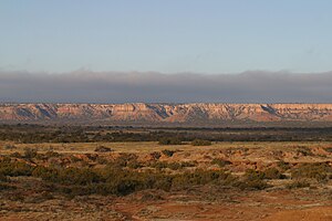
that resists erosion. In some places, the escarpment rises around 1,000 ft (300 m) above the plains to the east. The escarpment's features formed by erosion from rivers and streams, creating
173:
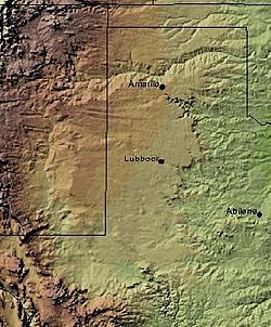
is clearly visible in this shaded relief image. The escarpment can be seen on the eastern edge of the Llano, running roughly in a north–south line through the middle of the
Panhandle of Texas.
679:
152:
417:
The overall slight upslope, and in some areas, convergent, terrain of the
Caprock is implicated in altering local weather and climate, such as enhancing
694:
433:
489:
440:, opened in 1982. A 65-mi (105-km) trail was developed within the park in 1992. Along the trail is Clarity Tunnel, home to a large colony of
53:
589:
Price, A.P. 1977. Mescalero
Sandhills of Cochran and Yoakum Counties, Texas. Master's thesis, Texas Tech University, Lubbock, 253 pp.
182:
469:
119:
704:
349:
In New Mexico, a prominent escarpment exists along the northernmost extension of the Llano
Estacado, especially to the south of
100:
519:
72:
57:
79:
276:
598:
Henderson, D. 2006. An
Introduction to the Mescalero Sands Ecosystem. Master's thesis, Texas A&M University, 42 pp.
699:
300:
310:
In Texas, the escarpment stretches around 200 mi (320 km) south-southwest from the northeast corner of the
86:
494:
263:
68:
709:
441:
358:
272:
46:
402:. One will notice the change in elevation of several hundred feet while crossing the Caprock Escarpment on
529:
354:
335:
319:
661:
609:
524:
459:
366:
343:
331:
327:
627:
534:
484:
411:
362:
350:
339:
323:
232:
361:. Along the western edge of the Llano Estacado, the portion of the escarpment that stretches from
479:
296:
93:
672:
386:
382:
247:
635:
514:
395:
565:
437:
399:
370:
311:
474:
667:
391:
304:
268:
170:
688:
509:
504:
464:
454:
418:
407:
403:
225:
499:
422:
17:
35:
680:
Public domain images of the Llano
Estacado, West Texas, and Eastern New Mexico
539:
292:
280:
237:
217:
143:
614:
11th
Conference on Mesoscale Processes / 32nd Conference on Radar Meteorology
197:
184:
656:
315:
639:
318:
border. The escarpment is especially notable, from north to south, in
262:
221:
299:
to describe the geographical transition point between the level
29:
608:
Walter, Kevin R.; C. C. Weiss; A. H.P. Swift (25 Oct 2005).
632:
Topographic
Influences on Amarillo Radar Echo Climatology
634:. M.S. thesis. Lubbock, TX: Texas Tech University.
616:. Albuquerque, NM: American Meteorological Society.
253:
243:
231:
213:
134:
60:. Unsourced material may be challenged and removed.
394:and highly diverse terrain, including the large
169:The Caprock Escarpment marking the edge of the
27:Geographical transition in Texas and New Mexico
8:
559:
557:
555:
131:
120:Learn how and when to remove this message
610:"The Moisture Route of Palo Duro Canyon"
551:
434:Caprock Canyons State Park and Trailway
252:
230:
212:
177:
161:
157:Caprock Escarpment, Garza County, Texas
149:
307:and the surrounding rolling terrain.
242:
7:
58:adding citations to reliable sources
25:
271:overlooking Alamogordo Valley of
695:Escarpments of the United States
655:
163:
151:
34:
520:Prairie Dog Town Fork Red River
45:needs additional citations for
1:
490:Geographical regions in Texas
425:initiation and organization.
267:Northwest escarpment of the
726:
381:The escarpment is made of
257:502 m (1,647 ft)
178:
162:
150:
141:
570:Handbook of Texas Online
442:Mexican free-tailed bats
705:Landforms of New Mexico
359:Quay County, New Mexico
530:Salt Fork Brazos River
284:
198:34.90972°N 104.06889°W
266:
664:at Wikimedia Commons
628:Marshall, Timothy P.
470:Double Mountain Fork
367:Maljamar, New Mexico
203:34.90972; -104.06889
69:"Caprock Escarpment"
54:improve this article
535:Yellow House Canyon
485:List of escarpments
412:San Jon, New Mexico
194: /
700:Landforms of Texas
662:Caprock Escarpment
480:Eastern New Mexico
297:Eastern New Mexico
291:is a term used in
289:Caprock Escarpment
285:
136:Caprock Escarpment
18:Caprock escarpment
673:Handbook of Texas
660:Media related to
387:calcium carbonate
261:
260:
130:
129:
122:
104:
16:(Redirected from
717:
659:
644:
643:
624:
618:
617:
605:
599:
596:
590:
587:
581:
580:
578:
576:
561:
515:Palo Duro Canyon
495:Little Red River
396:Palo Duro Canyon
369:, is called the
209:
208:
206:
205:
204:
199:
195:
192:
191:
190:
187:
167:
155:
132:
125:
118:
114:
111:
105:
103:
62:
38:
30:
21:
725:
724:
720:
719:
718:
716:
715:
714:
685:
684:
652:
647:
626:
625:
621:
607:
606:
602:
597:
593:
588:
584:
574:
572:
563:
562:
553:
549:
544:
450:
438:Quitaque, Texas
436:, located near
431:
400:Amarillo, Texas
379:
371:Mescalero Ridge
312:Texas Panhandle
202:
200:
196:
193:
188:
185:
183:
181:
180:
174:
158:
146:
137:
126:
115:
109:
106:
63:
61:
51:
39:
28:
23:
22:
15:
12:
11:
5:
723:
721:
713:
712:
710:Llano Estacado
707:
702:
697:
687:
686:
683:
682:
677:
665:
651:
650:External links
648:
646:
645:
619:
600:
591:
582:
564:Carroll, H.B.
550:
548:
545:
543:
542:
537:
532:
527:
522:
517:
512:
507:
502:
497:
492:
487:
482:
477:
472:
467:
462:
457:
451:
449:
446:
430:
427:
421:and promoting
378:
375:
305:Llano Estacado
269:Llano Estacado
259:
258:
255:
251:
250:
245:
241:
240:
235:
229:
228:
215:
211:
210:
176:
175:
171:Llano Estacado
168:
160:
159:
156:
148:
147:
142:
139:
138:
135:
128:
127:
42:
40:
33:
26:
24:
14:
13:
10:
9:
6:
4:
3:
2:
722:
711:
708:
706:
703:
701:
698:
696:
693:
692:
690:
681:
678:
676:
674:
669:
666:
663:
658:
654:
653:
649:
641:
637:
633:
629:
623:
620:
615:
611:
604:
601:
595:
592:
586:
583:
571:
567:
560:
558:
556:
552:
546:
541:
538:
536:
533:
531:
528:
526:
525:Ransom Canyon
523:
521:
518:
516:
513:
511:
510:Palmer Divide
508:
506:
505:Mushaway Peak
503:
501:
498:
496:
493:
491:
488:
486:
483:
481:
478:
476:
473:
471:
468:
466:
465:Caprock Chief
463:
461:
460:Canyon Valley
458:
456:
455:Blanco Canyon
453:
452:
447:
445:
443:
439:
435:
428:
426:
424:
420:
419:precipitation
415:
413:
409:
408:Adrian, Texas
405:
404:Interstate 40
401:
398:southeast of
397:
393:
388:
384:
376:
374:
372:
368:
364:
360:
356:
352:
347:
345:
341:
337:
333:
329:
325:
321:
317:
313:
308:
306:
302:
298:
294:
290:
282:
278:
274:
270:
265:
256:
249:
246:
239:
236:
234:
227:
226:United States
223:
219:
216:
207:
179:Coordinates:
172:
166:
154:
145:
140:
133:
124:
121:
113:
110:December 2009
102:
99:
95:
92:
88:
85:
81:
78:
74:
71: –
70:
66:
65:Find sources:
59:
55:
49:
48:
43:This article
41:
37:
32:
31:
19:
671:
631:
622:
613:
603:
594:
585:
573:. Retrieved
569:
500:Mount Blanco
475:Duffy's Peak
432:
423:thunderstorm
416:
385:—a layer of
380:
348:
309:
288:
286:
116:
107:
97:
90:
83:
76:
64:
52:Please help
47:verification
44:
377:Description
346:Counties.
301:High Plains
201: /
189:104°04′08″W
689:Categories
640:2346/22163
547:References
540:West Texas
357:, both in
293:West Texas
281:New Mexico
279:Counties,
238:Quaternary
218:New Mexico
186:34°54′35″N
144:Escarpment
80:newspapers
670:from the
566:"Caprock"
355:Tucumcari
314:near the
277:Guadalupe
254:Elevation
630:(1980).
575:March 1,
448:See also
406:between
316:Oklahoma
214:Location
668:Caprock
392:arroyos
383:caliche
363:Caprock
351:San Jon
336:Dickens
320:Briscoe
303:of the
248:Caliche
244:Geology
94:scholar
675:Online
344:Borden
342:, and
332:Crosby
328:Motley
96:
89:
82:
75:
67:
429:Parks
340:Garza
324:Floyd
222:Texas
101:JSTOR
87:books
577:2013
410:and
353:and
295:and
287:The
275:and
273:Quay
220:and
73:news
636:hdl
365:to
233:Age
56:by
691::
612:.
568:.
554:^
444:.
414:.
373:.
338:,
334:,
330:,
326:,
322:,
224:,
642:.
638::
579:.
283:.
123:)
117:(
112:)
108:(
98:·
91:·
84:·
77:·
50:.
20:)
Text is available under the Creative Commons Attribution-ShareAlike License. Additional terms may apply.