147:
140:
373:
291:
45:
854:
Sources differ on the height of Alam Kuh. Due to its elevation being very close to that of
Sabalan, either of these peaks may be variously listed as either the second or third highest mountain in Iran. Some sources give a significantly higher elevation for Alam Kuh of 4850 m. However, more reliable
315:. In addition to local climbers, the north face attracts European climbing teams. The first known ascent from the north was by a German party (Gorter/Steinauer) in 1936 via the northwest ridge.
930:
298:
The first recorded ascent of the peak was made from
Hazarchal over the south face by the German Bornmüller brothers during their six-month botanical exploration of the Alborz in 1902.
1431:
1012:
1003:
1436:
1421:
927:
872:
212:
96:
996:
327:
and consequent rockfall in 2004. The mountain was closed to climbers for some months because of the hazard of rockfall and loose cables.
976:
1279:
989:
889:
1416:
1397:
139:
1355:
859:(Alam Kuh has listed here as "Kuhha-ye Alborz") state an elevation of 4805 m based on Soviet topographic maps and modern
961:
89:
1120:
813:
324:
1095:
1043:
1426:
1360:
1329:
1216:
1211:
1200:
1194:
304:, a British mountaineer, climbed Alam-Kuh via the east ridge in 1933 and again in 1934 from over the west ridge.
1245:
1222:
1130:
1370:
1365:
1290:
1273:
1135:
1233:
1085:
1048:
1239:
1115:
1053:
1227:
1125:
1026:
267:
1376:
1350:
1334:
1110:
1339:
1318:
1295:
1251:
1206:
1105:
1100:
1080:
1058:
1037:
67:
1032:
1268:
1344:
1313:
1075:
82:
1307:
1301:
1285:
1070:
1064:
781:
271:
263:
77:
955:
773:
208:
372:
1393:
1389:
1090:
465:
307:
The 800 m high, steep granite north face provides some of the most difficult and challenging
1178:
709:
236:
934:
311:
routes in the country and the climbs rank alongside major climbing routes in the
European
278:
Province. With an elevation of 4,828 meters, it is the second-highest peak in Iran after
1173:
1163:
699:
611:
431:
308:
279:
255:
183:
1410:
633:
509:
738:
687:
655:
599:
589:
453:
301:
219:
202:
876:
950:
643:
621:
531:
856:
842:
1141:
791:
677:
475:
275:
172:
969:
111:
98:
665:
563:
519:
497:
981:
443:
421:
17:
1168:
799:
487:
843:"Iran: 54 Mountain Summits with Prominence of 1,500 meters or greater"
290:
1324:
863:
data. This data supports Alam Kuh as the second highest peak in Iran.
845:
Listed here as "Kuhha-ye Alborz". Peaklist.org. Retrieved 2012-02-25.
818:
553:
541:
348:
252:
190:
57:
44:
763:
748:
371:
860:
726:
312:
259:
176:
985:
323:
Most of the fixed ropes were severely damaged during a major
890:
Cambridge
Expedition, 1956, to the Elburz Mountains, Iran
335:
The mountain range supports permanent snow and glaciers.
410: 4,500 to 5,610 m (14,760 to 18,410 ft)
404: 3,500 to 4,500 m (11,500 to 14,800 ft)
977:"Iran: Alam Kuh" in The American Alpine Journal, 2002
398: 2,500 to 3,500 m (8,200 to 11,500 ft)
916:
The German expedition in the Elburz Range, N. Persia
392: 1,500 to 2,500 m (4,900 to 8,200 ft)
1261:
1187:
1151:
1019:
218:
201:
196:
182:
168:
127:
88:
76:
66:
56:
51:
32:
877:Beiträge zur Flora der Elbursgebirge Nord-Persiens
386: 500 to 1,500 m (1,600 to 4,900 ft)
903:Climbing in the Takht-i-Suleiman Group, N. Persia
918:: The Alpine Journal, v. 49, p. 245-247 (1937).
905:: The Alpine Journal, v. 47, p. 299–309 (1935).
380: −25 to 500 m (−82 to 1,640 ft)
997:
8:
1432:Tourist attractions in Mazandaran province
1004:
990:
982:
838:
836:
834:
29:
342:
289:
830:
7:
1394:International Wetland (Ramsar Site)
240:
25:
1396:- All names as inscribed by the
146:
1437:Mountains of Mazandaran province
145:
138:
43:
1398:Department of Environment, Iran
892:, The Himalayan Journal, Vol 20
1422:Four-thousanders of the Alborz
951:"Alam Kuh, Iran" on Peakbagger
937:CNN.com. Retrieved 2012-02-25.
928:"Deadly earthquake rocks Iran"
1:
62:4,850 m (15,910 ft)
266:Province, forming a peak of
72:1,827 m (5,994 ft)
814:List of Ultras of West Asia
1453:
1152:National Natural Monuments
370:
1386:
132:
112:36.3757361°N 50.9614750°E
42:
37:
325:6.3 magnitude earthquake
1013:Protected Areas of Iran
268:Takht-e Suleyman Massif
1417:Mountaineering in Iran
412:
295:
117:36.3757361; 50.9614750
375:
293:
331:Terrain and approach
272:Kelardasht District
270:. It is located in
108: /
1280:Arjan and Parishan
956:SummitPost website
933:2012-09-24 at the
413:
296:
294:A view of Alam kuh
52:Highest point
1404:
1403:
1390:Biosphere Reserve
805:
804:
251:is a mountain in
230:
229:
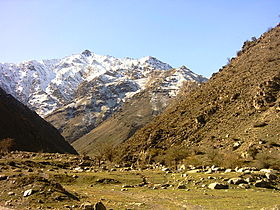
213:Joseph Bornmüller
16:(Redirected from
1444:
1427:Glaciers of Iran
1188:Wildlife Refuges
1006:
999:
992:
983:
973:
968:. Archived from
938:
925:
919:
912:
906:
899:
893:
888:J.G.R. Harding,
886:
880:
870:
864:
855:sources such as
852:
846:
840:
774:Emamzadeh Hashem
747:
737:
725:
708:
698:
686:
676:
664:
654:
642:
632:
620:
610:
598:
588:
579:
562:
552:
540:
530:
518:
508:
496:
486:
474:
464:
452:
442:
430:
420:
409:
403:
397:
391:
385:
379:
363:
343:
286:Climbing history
242:
222:
186:
149:
148:
142:
123:
122:
120:
119:
118:
113:
109:
106:
105:
104:
101:
47:
30:
27:Mountain in Iran
21:
1452:
1451:
1447:
1446:
1445:
1443:
1442:
1441:
1407:
1406:
1405:
1400:
1382:
1262:Protected Areas
1257:
1183:
1147:
1015:
1010:
960:
947:
942:
941:
935:Wayback Machine
926:
922:
913:
909:
900:
896:
887:
883:
871:
867:
853:
849:
841:
832:
827:
810:
782:Kandovan Tunnel
743:
733:
721:
704:
694:
682:
672:
660:
650:
638:
628:
616:
606:
594:
584:
575:
558:
548:
536:
526:
514:
504:
492:
482:
470:
460:
448:
438:
426:
416:
411:
407:
405:
401:
399:
395:
393:
389:
387:
383:
381:
377:
359:
347:Map of central
341:
333:
321:
319:2004 earthquake
288:
226:rock, snow, ice
220:
184:
164:
163:
162:
161:
160:
157:
156:
155:
154:
150:
116:
114:
110:
107:
102:
99:
97:
95:
94:
38:Kuhha-ye Alborz
28:
23:
22:
15:
12:
11:
5:
1450:
1448:
1440:
1439:
1434:
1429:
1424:
1419:
1409:
1408:
1402:
1401:
1387:
1384:
1383:
1381:
1380:
1374:
1368:
1363:
1358:
1353:
1348:
1342:
1337:
1332:
1327:
1322:
1316:
1311:
1305:
1299:
1293:
1288:
1283:
1277:
1271:
1265:
1263:
1259:
1258:
1256:
1255:
1249:
1243:
1237:
1231:
1225:
1220:
1214:
1209:
1204:
1198:
1191:
1189:
1185:
1184:
1182:
1181:
1176:
1174:Sarv-e Abarkuh
1171:
1166:
1161:
1155:
1153:
1149:
1148:
1146:
1145:
1139:
1133:
1128:
1123:
1118:
1113:
1108:
1103:
1098:
1093:
1088:
1083:
1078:
1073:
1068:
1062:
1056:
1051:
1046:
1044:Dayer-Nakhiloo
1041:
1035:
1030:
1023:
1021:
1020:National Parks
1017:
1016:
1011:
1009:
1008:
1001:
994:
986:
980:
979:
974:
972:on 2016-03-04.
958:
953:
946:
945:External links
943:
940:
939:
920:
907:
894:
881:
865:
847:
829:
828:
826:
823:
822:
821:
816:
809:
806:
803:
802:
794:
785:
784:
776:
767:
766:
758:
752:
751:
741:
730:
729:
719:
713:
712:
702:
691:
690:
680:
669:
668:
658:
647:
646:
636:
625:
624:
614:
603:
602:
592:
581:
580:
573:
567:
566:
556:
545:
544:
534:
523:
522:
512:
501:
500:
490:
479:
478:
468:
466:Ghal'eh Gardan
457:
456:
446:
435:
434:
424:
414:
406:
400:
394:
388:
382:
376:
368:
367:
357:
352:
340:
337:
332:
329:
320:
317:
309:mountaineering
287:
284:
280:Mount Damavand
256:mountain range
228:
227:
224:
216:
215:
205:
199:
198:
194:
193:
188:
180:
179:
170:
166:
165:
158:
152:
151:
144:
143:
137:
136:
135:
134:
133:
130:
129:
125:
124:
92:
86:
85:
80:
74:
73:
70:
64:
63:
60:
54:
53:
49:
48:
40:
39:
35:
34:
26:
24:
14:
13:
10:
9:
6:
4:
3:
2:
1449:
1438:
1435:
1433:
1430:
1428:
1425:
1423:
1420:
1418:
1415:
1414:
1412:
1399:
1395:
1391:
1385:
1378:
1375:
1372:
1369:
1367:
1364:
1362:
1359:
1357:
1354:
1352:
1349:
1346:
1343:
1341:
1338:
1336:
1333:
1331:
1328:
1326:
1323:
1320:
1317:
1315:
1312:
1309:
1306:
1303:
1300:
1297:
1294:
1292:
1289:
1287:
1284:
1281:
1278:
1275:
1272:
1270:
1267:
1266:
1264:
1260:
1253:
1250:
1247:
1244:
1241:
1238:
1235:
1232:
1229:
1226:
1224:
1221:
1218:
1215:
1213:
1210:
1208:
1205:
1202:
1199:
1196:
1193:
1192:
1190:
1186:
1180:
1177:
1175:
1172:
1170:
1167:
1165:
1162:
1160:
1157:
1156:
1154:
1150:
1143:
1140:
1137:
1134:
1132:
1129:
1127:
1124:
1122:
1121:Sorkh-e Hesar
1119:
1117:
1114:
1112:
1109:
1107:
1104:
1102:
1099:
1097:
1094:
1092:
1089:
1087:
1084:
1082:
1079:
1077:
1074:
1072:
1069:
1066:
1063:
1060:
1057:
1055:
1052:
1050:
1047:
1045:
1042:
1039:
1036:
1034:
1031:
1028:
1025:
1024:
1022:
1018:
1014:
1007:
1002:
1000:
995:
993:
988:
987:
984:
978:
975:
971:
967:
963:
959:
957:
954:
952:
949:
948:
944:
936:
932:
929:
924:
921:
917:
911:
908:
904:
898:
895:
891:
885:
882:
878:
874:
873:J. Bornmüller
869:
866:
862:
858:
851:
848:
844:
839:
837:
835:
831:
824:
820:
817:
815:
812:
811:
807:
801:
798:
795:
793:
790:
787:
786:
783:
780:
777:
775:
772:
769:
768:
765:
762:
759:
757:
754:
753:
750:
746:
742:
740:
736:
732:
731:
728:
724:
720:
718:
715:
714:
711:
707:
703:
701:
697:
693:
692:
689:
685:
681:
679:
675:
671:
670:
667:
663:
659:
657:
653:
649:
648:
645:
641:
637:
635:
631:
627:
626:
623:
619:
615:
613:
609:
605:
604:
601:
597:
593:
591:
587:
583:
582:
578:
574:
572:
569:
568:
565:
561:
557:
555:
551:
547:
546:
543:
539:
535:
533:
529:
525:
524:
521:
517:
513:
511:
510:Mishineh Marg
507:
503:
502:
499:
495:
491:
489:
485:
481:
480:
477:
473:
469:
467:
463:
459:
458:
455:
451:
447:
445:
441:
437:
436:
433:
429:
425:
423:
419:
415:
374:
369:
366:
362:
358:
356:
353:
351:
350:
345:
344:
338:
336:
330:
328:
326:
318:
316:
314:
310:
305:
303:
299:
292:
285:
283:
281:
277:
273:
269:
265:
261:
257:
254:
250:
246:
238:
234:
225:
223:
221:Easiest route
217:
214:
210:
206:
204:
200:
195:
192:
189:
187:
181:
178:
174:
171:
167:
141:
131:
126:
121:
103:50°57′41.31″E
100:36°22′32.65″N
93:
91:
87:
84:
81:
79:
75:
71:
69:
65:
61:
59:
55:
50:
46:
41:
36:
31:
19:
1158:
1131:Tang-e Sayad
970:the original
966:Peakware.com
965:
923:
915:
910:
902:
897:
884:
868:
850:
796:
788:
778:
770:
760:
755:
744:
734:
722:
716:
705:
695:
683:
673:
661:
651:
639:
629:
617:
607:
595:
585:
576:
570:
559:
549:
537:
527:
515:
505:
493:
483:
471:
461:
449:
439:
427:
417:
364:
360:
354:
346:
334:
322:
306:
302:Douglas Busk
300:
297:
258:in northern
248:
244:
232:
231:
203:First ascent
185:Parent range
1195:Amirkalayeh
914:D.L. Busk,
901:D.L. Busk,
532:Shah Alborz
454:Do Khaharan
115: /
90:Coordinates
1411:Categories
1371:Siahkeshim
1361:Mianjangal
1330:Kabir Kouh
1291:Dinar Kouh
1246:Sorkhankol
1223:Robat Shur
1142:Lake Urmia
1136:Khar Turan
1086:Kolahghazi
1049:Ghamishloo
962:"Alam-Kuh"
825:References
792:Latyan Dam
276:Mazandaran
264:Mazandaran
249:Mount Alam
173:Mazandaran
68:Prominence
1366:Mozaffari
1274:Arasbaran
1217:Miankaleh
1212:Miandasht
1201:Bakhtegan
1126:Tandooreh
1116:Siyahkooh
1054:Ghatroyeh
1027:Bakhtegan
700:Seh Hazar
498:Mehr Chal
245:Alam Kooh
153:ʿAlam-Kūh
128:Geography
58:Elevation
33:ʿAlam-Kūh
1310:(BR, IW)
1282:(BR, IW)
1234:Shadegan
1219:(BR, IW)
1164:Damavand
1159:Alam-Kuh
1144:(BR, IW)
1059:Golestan
931:Archived
857:Peaklist
808:See also
710:Shahrood
612:Do Hezar
564:Varavašt
444:Do Berar
432:Damavand
422:Azad Kuh
365:Alam-Kuh
339:Location
243:; also:
233:Alam-Kūh
207:1902 by
197:Climbing
169:Location
18:Alam Kuh
1392:- IW:
1356:Manesht
1340:Karkheh
1240:Shidvar
1169:Sabalan
1111:Sarigol
1096:Nayband
800:Lar Dam
717:Cities:
634:Jajrood
571:Rivers:
488:Kholeno
241:علمکوه
237:Persian
78:Listing
1377:Touran
1351:Koulak
1335:Karkas
1325:Jajrud
1269:Alvand
1252:Touran
1228:Selkeh
1207:Hamoon
1179:Taftan
1106:Salouk
1101:Paband
1081:Kiasar
1076:Khojir
1038:Bojagh
879:, 1908
819:Alamut
756:Other:
739:Chalus
688:Sardab
656:Kojoor
600:Chalus
590:Alamut
554:Tochal
542:Sialan
408:
402:
396:
390:
384:
378:
355:Peaks:
349:Alborz
253:Alborz
209:Alfred
191:Alborz
1345:Kavir
1319:Heleh
1314:Haraz
1296:Gando
1071:Khabr
1065:Kavir
1033:Bamou
764:Dizin
749:Karaj
644:Karaj
622:Haraz
247:) or
83:Ultra
1388:BR:
1379:(BR)
1373:(IW)
1347:(BR)
1321:(IW)
1308:Hara
1304:(BR)
1302:Geno
1298:(IW)
1286:Dena
1276:(BR)
1254:(BR)
1248:(IW)
1242:(IW)
1236:(IW)
1230:(IW)
1203:(IW)
1197:(IW)
1138:(BR)
1067:(BR)
1061:(BR)
1040:(IW)
1029:(IW)
861:SRTM
727:Amol
678:Noor
476:Gorg
313:Alps
260:Iran
211:and
177:Iran
159:Iran
1091:Lar
666:Lar
520:Naz
274:of
1413::
964:.
875:,
833:^
797:**
706:12
696:11
684:10
560:15
550:14
538:13
528:12
516:11
506:10
282:.
262:,
239::
175:,
1005:e
998:t
991:v
789:*
779:K
771:E
761:D
745:3
735:2
723:1
674:9
662:8
652:7
640:6
630:5
618:4
608:3
596:2
586:1
577:0
494:9
484:8
472:7
462:6
450:5
440:4
428:3
418:2
361:1
235:(
20:)
Text is available under the Creative Commons Attribution-ShareAlike License. Additional terms may apply.