377:. It burned in 1846, but was repaired. A second bridge was constructed in 1873, and replaced in 1907. A modern, four-lane bridge replaced the older bridge in 1965, and a second four-lane bridge added in 1969. In 2009, construction began on three spans (two carrying freeway traffic, one carrying local-only traffic) to replace the 1965 and 1969 bridges. The northbound bridge opened to traffic in December 2011 while the southbound bridge open to traffic in January 2012. The new bridges include new ramps and new interchanges with I-295 (the Anacostia Freeway). The local bridge opened to traffic in May 2012. Portions of all three bridges and their approaches remained under construction into 2013. Phase 1 of the project was completed ahead of schedule and within budget in July 2013. The local bridge was fully complete by September 2013. Phase 2 of the project, including the conversion of the Barney Circle Freeway into a boulevard, was completed in 2015.
511:
625:, the protesters said too few individuals from the Anacostia area (which suffers from a 30 percent unemployment rate) had been considered for employment or hired by Skanska/Facchina, the joint-venture construction company building the bridges. Skanska/Facchina vice president Brook Brookshire denied the accusations, noting that 51 percent of the new hires were D.C. residents, the company had engaged in extensive outreach to the unemployed, and that the company had worked with local jobs organizations, the D.C. Department of Employment Services, and the D.C. Department of Transportation to find workers for the project. Brookshire also said the company had provided training to unskilled workers to enable them to work on the project and find careers in the construction industry.
534:
872:, he pointed out that the "recreation bridge" connected two neighborhoods of only moderate population density, and was not easily accessed from either side of the river. He argued that the space would have to have enough activity and importance to make it a "destination" space day and night. He cautioned that the space could easily turn into a dead zone or encourage crime and that the space would have to be connected to the 11th Street Bridges local-only span's bicycle/pedestrian lanes. He also suggested that one or more DC Streetcar stops be created along the bridge.
457:: " are two-girder systems with steel composite construction and a central drop-in span on pin supports. The main girders are riveted and welded, and both have reinforced wall type piers with granite facing, supported by steel H piles." Each span was about 63 feet (19 m) wide. Each bridge had roughly five sections—four sections of about 170 feet (52 m) in length, with a center section about 234 feet (71 m) in length. Both spans were considered "fracture critical," which means that if one girder in the span fails the entire bridge is likely to collapse.
629:
434:
733:. The unfinished "mixing bowl" exchange on the southern terminus of the 11th Street Bridges was also altered. Local traffic was separated from through-traffic by the construction of a bridge dedicated for local traffic only, and ramps connecting the bridge to D.C. Route 295 were created. Construction of the new ramps began in May 2012, with the ramp from southbound D.C. Route 295 onto the 11th Street Bridge completed in July 2012. The ramp from the bridges to northbound D.C. Route 295 opened on December 19, 2012.
542:
526:
855:
features on the span. City planners argued the concept would connect parks and trails along both sides of the
Anacostia River, provide a "destination attraction" in the city's impoverished Southeast which could enhance retail sales as well as economic development in the area, and provide badly needed outdoor recreational facilities to residents of the Anacostia neighborhood. The cost of building a new span was estimated at between $ 25 and $ 35 million.
884:
908:
896:
826:
40:
442:
605:
752:. Priorities for the project included improving and restoring access to neighborhood streets, and adding pedestrian and bicycle connectivity to local streets and the Anacostia River waterfront. DDOT also began exploring whether to connect Southeast Boulevard to 12th, 13th, 14th, and 15th Streets SE. By 2014, DDOT's plan involved possible reconstructing of Barney Circle into an
597:
689:
would not have direct access to M Street as originally planned. Instead, motorists would confront a dead-end and be forced to take a detour east onto O Street SE, travel north on 12th Street NE, and then make a left to reach M Street SE. DDOT said the final outbound lane to
Anacostia as well as the bicycle/pedestrian lane would not be completed until the fall of 2012.
554:(DDOT) estimated in 2005 that traffic over the 11th Street Bridges would significantly expand to 105,100 vehicles per day by 2030, an increase of 22.2 percent over 2004 and more than 40.3 percent higher than the next-busiest bridge (Sousa Bridge). DDOT undertook a major study of the bridges in 2004 which concluded that both bridges should be replaced.
510:
95:
2457:
784:
For reasons which remain unclear, DDOT shuttered construction of the
Anacostia line in August 2010. Funding for the Anacostia Line over the 11th Street Bridges subsequently fell through as well. DDOT had applied for an $ 18 million Transportation Investment Generating Economic Recovery (TIGER) grant
636:
In May 2011, DDOT closed the off-ramp from the bridges to Martin Luther King Jr. Avenue SE. The agency said the closure would create a larger work area and speed up construction of the new bridges and approaches. Traffic was rerouted along the existing Good Hope Road on-ramp through the end of 2011,
549:
The
District of Columbia assessed the bridges in 2002. The Welsh Memorial Bridge was rated "satisfactory" (superstructure rating of 6; substructure rating of 6) while the 11th Street Bridge was rated "fair to poor" (superstructure rating of 5; substructure rating of 4). Both superstructures were near
854:
spur. The Office of
Planning's initial concept proposed building a new 925-foot (282 m) superstructure on the piers, complete with utilities (electricity, natural gas, sewage, fresh water). A self-sustaining public-private partnership would develop parks, restaurants, and outdoor entertainment
688:
In
January 2012, DDOT officials said that even when the third span opened in the summer of 2012, it would not be complete. DDOT said that one of the outbound traffic lanes would not be complete, nor would the pedestrian/bike lane. DDOT also admitted that Anacostia residents traveling into the city
612:
Lane closures on the bridges, as well lane closures and other traffic restrictions on nearby local roads and on- and off-ramps, began
October 26, 2010, as the construction moved from the middle of the Anacostia River toward the shore. City engineers estimated that the project was 25 percent complete
861:
Reaction to the plan was mixed. Attendees at the city's meeting were reported to be highly enthusiastic. But Beth
Purcell, president of the Capitol Hill Restoration Society, called the plan "bizarre" and argued that the city should not delay construction of the overlooks and fishing piers in favor
833:
DDOT originally planned to tear down the spans of the existing 11th Street
Bridges, but leave the piers standing. The agency planned to connect the bicycle/pedestrian lane on the new local-only span with two of the piers left over from the demolition of the downstream span. Pedestrian observation
581:
The entire replacement project was expected to cost $ 365 million. Demolition of a portion of the bridges began in July 2009 (a portion of M Street SE and I-295 access ramp at 12th Street SE were closed for two weekends to permit demolition of bridge ramps), and construction was scheduled to end in
557:
DDOT and the FHWA issued notices to proceed with further assessments in
September 2005, a draft environmental impact assessment was published in July 2006, a final environmental assessment was published in September 2007, and a decision to proceed promulgated in July 2008. Public hearings were held
404:
In 1820, the privately owned "Upper Navy Yard Bridge" was built over the Anacostia River at 11th Street SE. Also a toll bridge, this second bridge became a "free" bridge in 1848 after it was purchased by the federal government. From the city's founding until 1854, the area known today as Anacostia
728:
After the DDOT began the replacement of the 11th Street Bridges in 2009, it closed the westbound segment of Interstate 695 from the 11th Street Bridges to Barney Circle in late November 2012, and the eastbound lanes in early 2013. This portion of was Interstate 695 was subsequently decommissioned,
668:
routes were rerouted due to the span closure, adding significant travel times for Anacostia commuters. Motorists attempting to reach Anacostia were forced to use one of three time-consuming alternative routes: exit I-395 at the Sixth Street SE ramp, travel through local streets, and use an on-ramp
640:
In August 2011, the D.C. City Council designated the 11th Street Bridges, a portion of Southeast/Southwest Freeway, Maine Avenue SW, and Independence Avenue SW "Martin Luther King, Jr. Avenue" in honor of the slain civil rights leader. The dedication came in time for the planned dedication of the
780:
Metro stations. Design changes were made in the 11th Street Bridges to permit the streetcar tracks. In 2009, however, DDOT said the trolley cars would not travel down M Street SE/SW but rather proceed up 8th Street SE/NE to link with DC Streetcar's H Street Line. To help fund construction of the
663:
The opening of the new spans eliminated a dangerous portion of I-295 where motorists moving right to access the 11th Street Bridges mixed with motorists moving left as they entered the freeway from Firth Sterling Avenue SE. However, to allow local traffic access to the rest of the city, a set of
1306:
The original southbound span was named for District of Columbia police office Kevin J. Welsh, who drowned in 1986 while attempting to save a woman who had attempted to commit suicide by leaping from the bridge into the Anacostia River. Welsh's body was never recovered, and the D.C. City Council
656:
on December 16, 2011, to open the two bridges connecting I-295 with the Anacostia Freeway. The two spans were projected to carry 180,000 automobiles per day by 2032. The inbound I-295 span opened on Monday, December 19, 2011. The span carried both I-295 traffic as well as traffic coming up from
449:
Replacement of the 1907 span began in the 1960s. A modern, four-lane bridge carrying one-way northbound traffic opened next to the Anacostia Bridge on March 18, 1965 as part of the development of the "Inner Loop" (see below). A second four-lane bridge replaced the Anacostia Bridge in 1969, with
740:
named "Southeast Boulevard". The reconstruction project, estimated to take 18 to 24 months, raised the roadway 20 feet (6.1 m) to bring it level with the grade of the surrounding streets. The six-lane former highway began to be turned into a four-lane grand boulevard with a landscaped
616:
DDOT officials said in January 2011 that they expected a new connection with southbound I-295 to open during the spring, for construction on the two freeway spans to be complete by fall, and for the local span to open in 2013. Lane closures on the 11th Street Bridges, small segments of
2318:
657:
neighborhood streets in Anacostia until the separate Anacostia-only span opened in 2013. Officials in December 2011 predicted the local-only span, which was intended to carry not only automobiles but also include bicycle and pedestrian lanes, would open in the summer of 2012.
834:
platforms would be built on the piers. At both ends of the local-only span, the city also proposed building fishing piers, which would extend into the Anacostia River. The overlooks and fishing piers were expected to be completed in the fall of 2012 or the spring of 2013.
801:. As the first DHS headquarters building neared completion, the need for a streetcar line to move DHS workers from the Anacostia and Congressional Heights Metro lines into the heart of Anacostia became urgent. Federal and city officials also wanted to find a way to link the
816:
By June 2011, three public meetings had been held, in which 10 alternate routes for the streetcar line had been identified. In January 2012 the fourth public meeting narrowed the routes down to four alternatives for linking the Anacostia Metro station to the bridges.
613:
by late October 2010. The project was on track for completion in 2013. On November 5, 2010, construction crews began driving piles east of the bridge on its northern side to begin construction of the ramp connecting the new bridge to east-bound Southeast Freeway.
664:
temporary on- and off-ramps were made to give Anacostia residents access to the bridges. In March 2012, DDOT also closed the ramp leading from I-695 to the 11th Street Bridges so that new approaches and connections to the new spans could be constructed. Ten
789:
to build the trolley bed and lay tracks along the local span, but the federal agency denied the application in October 2010. Three days later, DDOT released a new DC Streetcar map showing the Anacostia Line terminating at the Anacostia Metro station.
517:
550:
maximum life expectancy. In 2004, the two bridges carried 86,000 vehicles per day, the second-largest volume of the four "middle Anacostia River" bridge crossings. Without improvements to traffic patterns across the Anacostia River, the
692:
DDOT announced in April 2012 that it was on schedule to open the new ramp from the bridge to northbound Anacostia Freeway in June, and the new inbound-ramp on the north side of the bridge (connecting with I-395) in September.
837:
However, in March 2012 the Office of Planning within the D.C. Mayor's office proposed retaining the downstream span and turning it into a recreational destination. The inspiration for the concept came from New York City's
2164:
409:
in 1854, and development slowly began to turn the agricultural land into businesses and residences. The destruction of the Eastern Branch Bridge in 1846, however, significantly slowed growth in the area for five decades.
620:
The bridges' construction sparked some controversy. On March 22, a citizens group named "D.C. Jobs or Else" organized a protest of about 50 individuals on the 11th Street Bridges. Joined by D.C. Council member
2326:
558:
in September 2005, December 2005, and July 2006. Because of design changes, the environmental impact study was re-evaluated in July 2009 and found to still be sufficient. The goals of the project were:
946:
721:(the Anacostia Freeway). The combination of traffic lights, left turn, and mixing of both through-traffic and local traffic created extensive traffic congestion on the Sousa Bridge during evening
1248:
413:
A second bridge was built in the same location as the Navy Yard Bridge in 1872–1873. This bridge was replaced in 1905-1907 by a stronger, wider span (the "Anacostia Bridge") which accommodated
2348:
858:
The city made its planning proposal about 45 to 60 days before demolition was to have begun on the existing span. It said it would hold a national design competition in the summer of 2012.
1198:"The Bill (H.R. 18198) Making Appropriations to Provide For the Expenses of the Government of the District of Columbia for the Fiscal Year Ending June 30, 1907, and for Other Purposes."
976:
District of Columbia Appropriations for 1970: Hearings Before the Subcommittee of the Committee on Appropriations, House of Representatives, Ninety-first Congress, First Session, Part 2
585:
On-ramps from Anacostia to the northbound span of the 11th Street Bridges were closed on December 20, 2009, for five and a half hours after heavy snow blocked the approaches during the
1574:
717:, wait at a traffic light on the southwestern terminus of the bridge, and make a left turn against oncoming traffic to access a narrow and dangerous ramp that led to northbound
1507:
453:
The southbound structure was officially named the Officer Kevin J. Welsh Memorial Bridge, while the northbound structure was officially named the 11th Street Bridge. Both were
520:
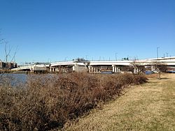
Panorama of the completed 11th Street Bridges. To the left are the flyovers and underpasses which make up the Suitland Parkway/D.C. Route 295 (Anacostia Freeway) interchange.
488:
2535:
1255:
953:
551:
143:
2550:
2540:
660:
Before the opening of the spans, DDOT received permission from the U.S. Department of Transportation to extend the designation of I-695 to the interchange with I-295.
2379:
781:
Anacostia Line, DDOT proposed transferring $ 10 million from demolition of the 11th Street Bridges, but put that plan on hold due to delays in the streetcar project.
637:
although this meant the ramp now carried two-way traffic in a single lane each way. Significant afternoon rush-hour delays occurred in the area due to the rerouting.
529:
Demolition and removal of a portion of the connecting span between the north span of the 11th Street Bridge and Interstate 695 (Southeast Freeway) on October 10, 2009
495:
portions of the plan. The unbuilt portions of the project were finally cancelled in 1977. Several ramps allowing traffic on the 11th Street Bridges to access I-295/
1539:
1589:
1001:
794:
2016:
2545:
1412:
786:
1546:
2525:
2490:
2104:
773:
57:
632:
Signage on the new inbound span of the 11th Street Bridges shows the connection with I-695, which will be marked for the first time in its history.
730:
710:
1353:
30:5 (July 2004); Mohl, Raymond A. "The Interstates and the Cities: The U.S. Department of Transportation and the Freeway Revolt, 1966-1973."
492:
473:
359:
355:
98:
1798:
The routes affected were 90, 92, 93, A42, A46, A48, B2, P2, P6, and U2. See: Thomson, Robert. "Bus Routes Detour for 11th St. Bridge Work."
1486:
1826:
957:
2411:
1259:
2520:
2515:
2510:
2505:
2500:
2495:
2466:
477:
1501:
2354:. 11th Street Bridge Project Office. Office of Planning. Office of the Mayor. Government of the District of Columbia. March 12, 2012
1461:
1450:
1378:
1366:
1227:
1186:
1166:
1146:
1079:
1049:
802:
1983:
702:
499:
and I-695 eastbound remained unbuilt because of these cancellations, creating severe traffic problems on both ends of the bridges.
2406:
1504:
Record of Decision: 11th Street Bridges: Anacostia Freeway (I-295/DC 295) to Southeast/Southwest Freeway (I-695), Washington, D.C.
1349:
November 26, 2000; Schrag, Zachary M. "The Freeway Fight in Washington, D.C.: The Three Sisters Bridge in Three Administrations."
642:
1465:
709:
in Maryland (the John Hanson Highway) would often travel Interstate 695 to Barney Circle, wait at the traffic light there, use
586:
468:
for the District of Columbia. The innermost beltway would have formed a flattened oval about a mile in radius centered on the
1489:
Re-Evaluation: 11th Street Bridges: Anacostia Freeway (I-295/DC 295) to Southeast/Southwest Freeway (I-695), Washington, D.C.
1457:
1209:
810:
764:
The local span of the new 11th Street Bridges was designed to accommodate a lane for the trolley cars of the city's emerging
753:
718:
496:
363:
533:
461:
2139:
1927:
481:
306:
50:
628:
665:
367:
1197:
1005:
393:
built between 1795 and 1800 about 0.25 miles (0.40 km) upstream from 11th Street SE (at the site of the current
2156:
1967:
Thomson, Robert (December 30, 2012). "With A New Freeway Link, Is It Time to Reconsider How the Roads Are Marked?".
1200:
Subcommittee of the Committee on Appropriations. U.S. Senate. Washington, D.C.: Government Printing Office, 1906.
777:
2407:"The 11th Street Bridges: What & Why." Anacostia Waterfront Initiative. Government of the District of Columbia
2263:
851:
769:
706:
678:
1443:
The ratings apply to the three primary components of a bridge: the deck, superstructure, and substructure. See:
863:
472:. The middle beltway would have formed an arc along the northern portion of the city, running from the proposed
2445:
1179:
A Guide to Black Washington: Places and Events of Historical and Cultural Significance in the Nation's Capital.
1122:
714:
682:
394:
433:
798:
653:
645:. The renaming was honorary, and did not formally change the names of these bridges, highways, and streets.
617:
Southeast-Southwest Freeway, I-295, and local streets began on March 23, 2011, and continued through June.
2530:
2101:
1097:
768:
tram system. The Anacostia Line of the streetcar system was originally intended to travel north from the
673:
to access the undemolished old outbound bridge; continue onto I-295 and exit at Howard Road SE; exit onto
578:
The project also included a pedestrian walkway to provide foot traffic access across the bridges as well.
385:
The first bridge across the Anacostia River in this area was the Eastern Branch Bridge, a privately owned
745:
and pedestrian nature trail. Southeast Boulevard was designed to link Barney Circle to 11th Street SE.
541:
401:
soldiers in August 1814 during the War of 1812. It was rebuilt, but burned completely in August 1846.
912:
847:
813:
began holding a series of public meetings to determine how to link the 11th Street Bridges with DHS.
674:
670:
1292:
868:
589:, with the snow removal disrupting automobile traffic and forcing the temporary closure of several
437:
Photo of the 1907 built Anacostia Bridge with the under construction 11th Street Bridge next to it.
900:
806:
422:
17:
2233:
974:
525:
1374:
1362:
1223:
1213:
1182:
1162:
1142:
1075:
1851:
Thomson, Robert (August 18, 2011). "At Four-Way Stops, A Risky Maximization of Opportunity".
1308:
16:
This article is about bridges in Washington, DC, USA. For the bridge in Tulsa, Oklahoma, see
2412:
Middle Anacostia River Crossings Transportation Study. Justice and Sustainability Associates
2074:
2058:
888:
756:
as well. DDOT planners said that construction on this project might begin as early as 2016.
590:
347:
119:
862:
of an unstudied design proposal with no funding. David Alpert, of the prominent local blog
2428:
2108:
1511:
1454:
1101:
883:
825:
649:
343:
109:
39:
2325:. Office of the Mayor. Government of the District of Columbia. April 2012. Archived from
1444:
1220:
15 Stars: Eisenhower, MacArthur, Marshall: Three Generals Who Saved the American Century.
772:
to a streetcar station at the southern foot of the local span before connecting with the
1990:
1989:(Report). Washington, D.C.: D.C. Department of Transportation. p. 2. Archived from
1741:"Opening of Inbound 11th Street Bridge Should Start to Ease Commutes This Week in DC."
1447:
Status of the Nation's Highways, Bridges, and Transit: 2004 Conditions and Performance.
441:
895:
2484:
1523:
Jenkins, Chris L. "'Every Neighborhood Needs a Cheers, and Maybe This Can Be Ours'."
1385:
July 13, 1973; Feaver, Douglas B. "Three Sisters Highway Project Is Killed - Again."
749:
701:
Since the cancellation of the Inner Loop Expressway, motorists wanting to access the
398:
351:
123:
1678:
Brookshire, Brook. "A Construction Project Committed to Hiring District Residents."
2417:
D.C. Dept. of Transportation video on the reconstruction of the 11th Street Bridges
1891:
Thomson, Robert (August 16, 2012). "Freeway Fragment to Undergo An Identity Swap".
1070:
The Anacostia River was originally called the "Eastern Branch." See: Abbott, Carl.
765:
742:
622:
604:
562:
to reduce traffic congestion on both the 11th Street Bridges and on local streets;
2421:
1728:
Halsey III, Ashley. "Two Bridges Across Anacostia Are Ready Ahead of Schedule."
843:
469:
386:
374:
158:
2040:
Layton, Lyndsey. "Light-Rail Project Would Link Anacostia With Southwest D.C."
1123:
Burr, Charles R. "A Brief History of Anacostia, Its Name, Origin and Progress."
571:
to provide an improved emergency evacuation route for the nation's capital; and
2416:
1072:
Political Terrain: Washington, D.C., from Tidewater Town to Global Metropolis.
1028:"11th Street Bridges Reconstruction - JDLand/Near Southeast DC Revitalization"
418:
390:
397:). The Eastern Branch Bridge was blown up and partially burned by retreating
72:
59:
2140:
Kravitz, Derek. "Details Emerge for D.C. Streetcars, Set to Begin in 2012."
2125:
2111:
2088:
Sun, Lena H. "Streetcars Could Be Running on D.C. Roads by Late Next Year."
839:
737:
736:
The decommissioned portion of Interstate 695 began to be transformed into a
722:
596:
574:
to provide routes for security personnel in and out of the nation's capital.
2349:"11th Street Bridge Project. Community Communications Committee Meeting 10"
729:
turning roughly five blocks of six-lane highway into city streets from the
648:
The non-local spans were finished months ahead of schedule, and D.C. Mayor
373:
The first bridge at the site, constructed about 1800, played a role in the
1290:
Cohn, D'Vera. "Suit Seeks to Stop D.C. Plans to Build Connector Highway."
2022:(Report). Washington, D.C.: D.C. Department of Transportation. p. 10
1027:
1911:
Thomson, Robert (October 7, 2012). "Bridge Ramps Remake D.C. Freeways".
1869:
Thomson, Robert (May 27, 2012). "Piece By Piece at 11th Street Bridge".
809:
facilities at the Washington Navy Yard to the DHS campus. DDOT and the
2268:
2185:
Medici, Andy. "Homeland Security Further Delays Headquarters Project."
1982:
District of Columbia Department of Transportation (November 21, 2013).
1952:
DeBonis, Mike (November 28, 2011). "Interstate 695 Reappears in D.C.".
465:
23:
Complex of three bridges across the Anacostia River in Washington, D.C.
1309:
Kelly, John F. "Bridges Carry Bits of History Along With the Traffic."
454:
339:
1540:
Thomson, Robert. "DC to Rebuild 11th Street Bridges over Anacostia."
2290:
2015:
District of Columbia Department of Transportation (March 6, 2014).
1984:
Barney Circle and Southeast Boulevard Transportation Planning Study
1633:
Thomson, Robert and Berman, Mark. "Big Year Ahead for Road, Rail."
1785:
Thomson, Robert. "Second Span of New 11th Street Bridge to Open."
824:
627:
603:
595:
540:
532:
524:
460:
In 1956, federal and regional transportation planners proposed an
440:
432:
2456:
2198:
Khan, Sarah. "H Street Streetcars Now On Track to Run By 2013."
1373:
Rev. ed. Knoxville, Tenn.: University of Tennessee Press, 1990.
565:
to increase the safety of all types of traffic on local streets;
414:
406:
2425:
1445:
Federal Highway Administration. "Bridge System Conditions." In
1415:
uses the following scale to rate bridge component conditions:
487:
Two decades of protest led to the cancellation of all but the
1759:
Thomson, Robert. "D.C.'s 11th St. Bridge Opening in Phases."
1074:
Chapel Hill, N.C.: University of North Carolina Press, 1999.
405:
was primarily sparsely populated farmland. But Anacostia was
1359:
The Great Society Subway: A History of the Washington Metro.
1002:"11th Street Bridge Project - Anacostia Waterfront, DC DDOT"
608:
11 Street Bridges and Martin Luther King Jr Ave Looking West
1620:
Thomson, Robert. "Anacostia Bridge Building in New Phase."
1590:
Thomson, Robert. "11th St. Bridge Work to Disrupt Traffic."
1398:
Lynton, Stephen J. "D.C. Plans to Link Two City Freeways."
2157:"Ground Broken on $ 3.4 Billion Homeland Security Complex"
2123:
Morrissey, Aaron. "DDOT Releases Updated Streetcar Plan."
1381:; Eisen, Jack. "Md. Vetoes I-95 Extension Into District."
445:
The north end of the original 11th Street Bridges in 1992.
1696:
Thomson, Robert. "Dr. Gridlock's Traffic, Transit Tips."
1604:
Thomson, Robert. "What's Ahead for D.C. Transportation?"
1345:
Levey, Bob and Levey, Jane Freundel. "End of The Roads."
797:(DHS) headquarters on what used to be the west campus of
2056:
Nevola, Molly. "Streetcars On Track for Return to D.C."
1772:
Thomson, Robert. "Dr. Gridlock's Traffic Transit Tips."
1139:
The Burning of Washington: The British Invasion of 1814.
989:...The twin 11th Street Bridges, which are now in use...
793:
However, in October 2009, construction began on the new
133:
Officer Kevin J. Welsh Memorial Bridge (southbound span)
2319:"11th Street Bridge Recreation and Destination Concept"
1126:
Records of the Columbia Historical Society, Washington.
2102:
Broom, Scott. "DC's Streetcar Project Halted For Now."
1928:"Sousa Bridge Access to Freeway/395 to Close Thursday"
1712:
DeBonis, Mike. "A Hitch in City's Plan to Honor MLK."
1161:
Baltimore, Md.: Johns Hopkins University Press, 1995.
1547:
Craig, Tim. "11th Street Bridge Plans Gets Go-Ahead."
979:. U.S. Government Printing Office. 1969. p. 1081
1662:Ruane, Michael E. "Protesters Demand Bridge Jobs."
1616:
1614:
1502:District of Columbia Department of Transportation.
1487:District of Columbia Department of Transportation.
1482:
1480:
1478:
1476:
1474:
1323:District of Columbia Department of Transportation,
1159:
Washington Seen: A Photographic History, 1875-1965.
421:fled across on July 28, 1932, when attacked by the
323:
315:
305:
300:
268:
193:
188:
180:
172:
164:
154:
149:
139:
129:
115:
105:
88:
49:
30:
2264:"4 Futuristic Designs for DC's Very Own High Line"
1811:Thomson, Robert. "Spring Changes for Nats Park."
1361:Baltimore: Johns Hopkins University Press, 2006.
1256:District of Columbia Department of Transportation
954:District of Columbia Department of Transportation
552:District of Columbia Department of Transportation
358:across the Anacostia to its southern terminus at
144:District of Columbia Department of Transportation
1755:
1753:
1751:
1371:Interstate: Express Highway Politics, 1939-1989.
866:, was more muted in his criticism. Writing for
2373:
2371:
2369:
2313:
2311:
1886:
1884:
1882:
1880:
1724:
1722:
1307:renamed the southbound span in his honor. See:
821:Proposed 11th Street Bridges recreation project
366:. The bridges also connect the neighborhood of
1906:
1904:
1902:
1210:Manchester, William. "Rock Bottom in America."
537:11th Street Bridges under construction in 2011
450:one-way traffic over the span of each bridge.
44:The 11th Street Bridges from the south in 2015
1674:
1672:
1535:
1533:
1243:
1241:
1239:
1237:
1235:
1141:Annapolis, Md.: Naval Institute Press, 2000.
795:United States Department of Homeland Security
748:In 2013, DDOT published plans to reconfigure
8:
1341:
1339:
1337:
1335:
1333:
941:
939:
937:
935:
933:
931:
929:
927:
480:to near 37th Street NW at the north end of
2422:
2227:
2225:
2223:
2221:
2052:
2050:
1864:
1862:
1658:
1656:
1413:United States Department of Transportation
1177:Fitzpatrick, Sandra and Goodwin, Maria R.
850:built on a section of the former elevated
829:11th Street Bridges from the water in 2018
787:United States Department of Transportation
545:Underside of the completed bridges in 2015
27:
2072:"Officials Tout Plan to Use Streetcars."
1827:"D.C. Preparing to Open New Highway Link"
1093:
1091:
1089:
1087:
1004:. Anacostiawaterfront.org. Archived from
370:with the rest of the city of Washington.
2536:Bridges on the Interstate Highway System
2211:McArdle, Terence. "D.C. News in Brief."
1708:
1706:
1692:
1690:
1688:
1646:"Dr. Gridlock's Traffic, Transit Tips."
600:11 Street Bridges and I-695 Looking West
2551:1965 establishments in Washington, D.C.
2541:Former toll bridges in Washington, D.C.
2114:. August 26, 2010. Accessed 2010-08-31.
1157:Miller, Frederic and Gillette, Howard.
923:
2380:"Making a 'Recreation Bridge' Succeed"
1276:"New 11th Street Bridge Opens Today".
1118:
1116:
1114:
1112:
2241:Capitol Hill Restoration Society News
2234:"President's Column: Pure Adrenalin?"
1825:Thomson, Robert (December 18, 2012).
1098:Croggon, James. "Old 'Burnt Bridge'."
7:
2262:Alissa Walker (September 12, 2014).
1222:New York: Simon and Schuster, 2007.
1218:August 5, 1974; Weintraub, Stanley.
135:11th Street Bridge (northbound span)
1575:"Ramp Closures at 11th St. Bridge."
1325:11th Street Bridge Design Workshop,
2467:Frederick Douglass Memorial Bridge
2167:from the original on March 4, 2012
2017:Projects Update Meeting For Ward 7
1926:Freeman, Amy (November 27, 2012).
1258:. October 11, 2005. Archived from
1181:New York: Hippocrene Books, 1990.
956:. October 11, 2005. Archived from
478:Robert F. Kennedy Memorial Stadium
14:
2546:Beam bridges in the United States
1561:Thomson, Robert. "Dr. G's Tips."
1462:U.S. Department of Transportation
2526:Road bridges in Washington, D.C.
2491:Bridges over the Anacostia River
2455:
2378:Alpert, David (March 29, 2012).
1357:20:2 (2008); Schrag, Zachary M.
906:
894:
882:
803:8th Street Marine Corps Barracks
643:Martin Luther King, Jr. Memorial
509:
93:
38:
1466:U.S. Government Printing Office
587:North American blizzard of 2009
568:to replace the current bridges;
464:, one of three circumferential
1458:Federal Transit Administration
811:Federal Transit Administration
1:
2437:
754:intermodal transportation hub
593:routes which use the bridge.
417:. It was this span which the
2232:Purcell, Beth (April 2012).
703:Baltimore–Washington Parkway
256:; 11 years ago
241:; 12 years ago
226:; 12 years ago
2567:
2161:CNN.com. September 9, 2009
1355:Journal of Policy History.
864:Greater Greater Washington
681:; or continue east to the
200:: March 18, 1965
101:, 4 lanes of local traffic
15:
2521:Bridges completed in 2013
2516:Bridges completed in 2012
2511:Bridges completed in 2011
2506:Bridges completed in 1969
2501:Bridges completed in 1965
2496:Bridges completed in 1907
2461:
2450:
2440:
2435:
1510:January 14, 2016, at the
1453:October 19, 2008, at the
1351:Journal of Urban History.
852:New York Central Railroad
679:Frederick Douglass Bridge
328:
37:
2446:John Philip Sousa Bridge
2295:Friends of the High Line
913:United States portal
683:John Philip Sousa Bridge
395:John Philip Sousa Bridge
286:Original Southbound span
273:Original Northbound span
210:Original Southbound span
198:Original Northbound span
799:St. Elizabeths Hospital
770:Anacostia Metro station
731:National Highway System
654:ribbon-cutting ceremony
338:are a complex of three
1442:
901:Engineering portal
830:
633:
609:
601:
546:
538:
530:
446:
438:
2291:"About the High Line"
1416:
828:
631:
607:
599:
544:
536:
528:
474:Barney Circle Freeway
462:Inner Loop Expressway
444:
436:
354:. The bridges convey
311:86,000 per day (2004)
168:931 feet (284 m)
2213:The Washington Post.
2200:The Washington Post.
2142:The Washington Post.
2090:The Washington Post.
2042:The Washington Post.
1813:The Washington Post.
1800:The Washington Post.
1787:The Washington Post.
1774:The Washington Post.
1761:The Washington Post.
1730:The Washington Post.
1714:The Washington Post.
1698:The Washington Post.
1680:The Washington Post.
1664:The Washington Post.
1648:The Washington Post.
1635:The Washington Post.
1622:The Washington Post.
1606:The Washington Post.
1593:The Washington Post.
1578:The Washington Post.
1563:The Washington Post.
1550:The Washington Post.
1543:The Washington Post.
1525:The Washington Post.
1464:. Washington, D.C.:
1400:The Washington Post.
1387:The Washington Post.
1383:The Washington Post.
1347:The Washington Post.
1327:May 25, 2005, p. 12.
889:Transport portal
774:Navy Yard – Ballpark
713:to cross the nearby
675:South Capitol Street
671:Washington Navy Yard
224:: December 2011
184:234 feet (71 m)
2452:11th Street Bridges
2384:The Washington Post
2044:September 19, 2002.
1969:The Washington Post
1954:The Washington Post
1913:The Washington Post
1893:The Washington Post
1871:The Washington Post
1853:The Washington Post
1831:The Washington Post
1552:September 22, 2009.
1402:September 26, 1983.
1293:The Washington Post
1278:The Washington Post
869:The Washington Post
711:Pennsylvania Avenue
697:Southeast Boulevard
336:11th Street Bridges
254:: January 2013
239:: January 2012
237:New Southbound span
222:New Northbound span
176:63 feet (19 m)
73:38.8719°N 76.9895°W
69: /
32:11th Street Bridges
2323:Office of Planning
2189:February 19, 2012.
2107:2012-03-20 at the
2079:February 26, 2009.
1776:December 18, 2011.
1745:December 19, 2011.
1732:December 17, 2011.
1580:December 20, 2009.
1527:February 13, 2011.
1137:Pitch, Anthony S.
831:
807:United States Navy
634:
610:
602:
547:
539:
531:
447:
439:
423:United States Army
283:(46–47 years old)
18:11th Street Bridge
2478:
2477:
2473:
2472:
2215:January 19, 2012.
2144:October 24, 2010.
2130:October 20, 2010.
1996:on April 29, 2014
1743:Associated Press.
1624:November 5, 2010.
1608:October 21, 2010.
1595:October 25, 2010.
1280:. March 18, 1965.
1214:New York Magazine
1008:on March 30, 2014
497:Anacostia Freeway
332:
331:
296:(42–43 years old)
78:38.8719; -76.9895
2558:
2459:
2438:
2423:
2395:
2394:
2392:
2390:
2375:
2364:
2363:
2361:
2359:
2353:
2345:
2339:
2338:
2336:
2334:
2329:on July 27, 2014
2315:
2306:
2305:
2303:
2301:
2287:
2281:
2280:
2278:
2276:
2259:
2253:
2252:
2250:
2248:
2238:
2229:
2216:
2209:
2203:
2196:
2190:
2183:
2177:
2176:
2174:
2172:
2155:Ahlers, Mike M.
2152:
2146:
2137:
2131:
2121:
2115:
2099:
2093:
2086:
2080:
2075:Washington Times
2070:
2064:
2059:Washington Times
2054:
2045:
2038:
2032:
2031:
2029:
2027:
2021:
2012:
2006:
2005:
2003:
2001:
1995:
1988:
1979:
1973:
1972:
1964:
1958:
1957:
1949:
1943:
1942:
1940:
1938:
1923:
1917:
1916:
1908:
1897:
1896:
1888:
1875:
1874:
1866:
1857:
1856:
1848:
1842:
1841:
1839:
1837:
1822:
1816:
1809:
1803:
1802:January 7, 2012.
1796:
1790:
1789:January 5, 2012.
1783:
1777:
1770:
1764:
1763:January 8, 2012.
1757:
1746:
1739:
1733:
1726:
1717:
1716:August 17, 2011.
1710:
1701:
1694:
1683:
1676:
1667:
1660:
1651:
1644:
1638:
1637:January 2, 2011.
1631:
1625:
1618:
1609:
1602:
1596:
1587:
1581:
1572:
1566:
1559:
1553:
1545:April 24, 2009;
1537:
1528:
1521:
1515:
1499:
1493:
1484:
1469:
1432:'6' Satisfactory
1409:
1403:
1396:
1390:
1369:; Rose, Mark H.
1343:
1328:
1321:
1315:
1312:Washington Post.
1304:
1298:
1288:
1282:
1281:
1273:
1267:
1266:
1264:
1253:
1245:
1230:
1207:
1201:
1195:
1189:
1175:
1169:
1155:
1149:
1135:
1129:
1120:
1107:
1095:
1082:
1068:
1062:
1061:
1059:
1057:
1050:"Photo Collages"
1046:
1040:
1039:
1037:
1035:
1024:
1018:
1017:
1015:
1013:
998:
992:
991:
986:
984:
971:
965:
964:
962:
951:
943:
911:
910:
909:
899:
898:
887:
886:
513:
348:Washington, D.C.
295:
293:
282:
280:
264:
262:
257:
249:
247:
242:
234:
232:
227:
219:
217:
207:
205:
120:Washington, D.C.
97:
96:
84:
83:
81:
80:
79:
74:
70:
67:
66:
65:
62:
42:
28:
2566:
2565:
2561:
2560:
2559:
2557:
2556:
2555:
2481:
2480:
2479:
2474:
2469:
2465:
2454:
2448:
2444:
2431:
2429:Anacostia River
2427:Bridges of the
2403:
2398:
2388:
2386:
2377:
2376:
2367:
2357:
2355:
2351:
2347:
2346:
2342:
2332:
2330:
2317:
2316:
2309:
2299:
2297:
2289:
2288:
2284:
2274:
2272:
2261:
2260:
2256:
2246:
2244:
2236:
2231:
2230:
2219:
2210:
2206:
2197:
2193:
2184:
2180:
2170:
2168:
2154:
2153:
2149:
2138:
2134:
2122:
2118:
2109:Wayback Machine
2100:
2096:
2087:
2083:
2071:
2067:
2063:March 15, 2009.
2055:
2048:
2039:
2035:
2025:
2023:
2019:
2014:
2013:
2009:
1999:
1997:
1993:
1986:
1981:
1980:
1976:
1966:
1965:
1961:
1951:
1950:
1946:
1936:
1934:
1925:
1924:
1920:
1910:
1909:
1900:
1890:
1889:
1878:
1868:
1867:
1860:
1850:
1849:
1845:
1835:
1833:
1824:
1823:
1819:
1810:
1806:
1797:
1793:
1784:
1780:
1771:
1767:
1758:
1749:
1740:
1736:
1727:
1720:
1711:
1704:
1695:
1686:
1682:March 25, 2011.
1677:
1670:
1666:March 23, 2011.
1661:
1654:
1650:March 20, 2011.
1645:
1641:
1632:
1628:
1619:
1612:
1603:
1599:
1588:
1584:
1573:
1569:
1560:
1556:
1538:
1531:
1522:
1518:
1512:Wayback Machine
1500:
1496:
1492:July 15, 2009.
1485:
1472:
1455:Wayback Machine
1437:
1435:
1433:
1431:
1429:
1427:
1425:
1423:
1419:
1410:
1406:
1397:
1393:
1344:
1331:
1322:
1318:
1314:April 21, 2005.
1305:
1301:
1289:
1285:
1275:
1274:
1270:
1265:on May 2, 2009.
1262:
1251:
1247:
1246:
1233:
1208:
1204:
1196:
1192:
1176:
1172:
1156:
1152:
1136:
1132:
1121:
1110:
1096:
1085:
1069:
1065:
1055:
1053:
1048:
1047:
1043:
1033:
1031:
1026:
1025:
1021:
1011:
1009:
1000:
999:
995:
982:
980:
973:
972:
968:
963:on May 2, 2009.
960:
949:
945:
944:
925:
921:
907:
905:
893:
881:
878:
823:
762:
699:
650:Vincent C. Gray
523:
522:
521:
519:
514:
505:
503:2009 rebuilding
431:
383:
344:Anacostia River
291:
289:
284:
278:
276:
260:
258:
255:
250:
245:
243:
240:
235:
230:
228:
225:
220:
215:
213:
208:
203:
201:
150:Characteristics
134:
110:Anacostia River
94:
77:
75:
71:
68:
63:
60:
58:
56:
55:
45:
33:
24:
21:
12:
11:
5:
2564:
2562:
2554:
2553:
2548:
2543:
2538:
2533:
2528:
2523:
2518:
2513:
2508:
2503:
2498:
2493:
2483:
2482:
2476:
2475:
2471:
2470:
2460:
2449:
2436:
2433:
2432:
2426:
2420:
2419:
2414:
2409:
2402:
2401:External links
2399:
2397:
2396:
2365:
2340:
2307:
2282:
2254:
2217:
2204:
2202:June 30, 2011.
2191:
2187:Federal Times.
2178:
2147:
2132:
2116:
2094:
2092:July 13, 2008.
2081:
2065:
2046:
2033:
2007:
1974:
1959:
1944:
1918:
1898:
1876:
1858:
1843:
1817:
1815:April 8, 2012.
1804:
1791:
1778:
1765:
1747:
1734:
1718:
1702:
1684:
1668:
1652:
1639:
1626:
1610:
1597:
1582:
1567:
1565:July 12, 2009.
1554:
1529:
1516:
1494:
1470:
1404:
1391:
1329:
1316:
1299:
1283:
1268:
1231:
1202:
1190:
1170:
1150:
1130:
1108:
1083:
1063:
1041:
1019:
993:
966:
922:
920:
917:
916:
915:
903:
891:
877:
874:
822:
819:
761:
760:Streetcar lane
758:
719:D.C. Route 295
698:
695:
576:
575:
572:
569:
566:
563:
516:
515:
508:
507:
506:
504:
501:
476:terminus near
430:
427:
382:
379:
360:Interstate 295
356:Interstate 695
330:
329:
326:
325:
321:
320:
317:
313:
312:
309:
303:
302:
298:
297:
270:
266:
265:
195:
191:
190:
186:
185:
182:
178:
177:
174:
170:
169:
166:
162:
161:
156:
152:
151:
147:
146:
141:
137:
136:
131:
127:
126:
117:
113:
112:
107:
103:
102:
90:
86:
85:
53:
47:
46:
43:
35:
34:
31:
22:
13:
10:
9:
6:
4:
3:
2:
2563:
2552:
2549:
2547:
2544:
2542:
2539:
2537:
2534:
2532:
2531:Interstate 95
2529:
2527:
2524:
2522:
2519:
2517:
2514:
2512:
2509:
2507:
2504:
2502:
2499:
2497:
2494:
2492:
2489:
2488:
2486:
2468:
2464:
2458:
2453:
2447:
2443:
2439:
2434:
2430:
2424:
2418:
2415:
2413:
2410:
2408:
2405:
2404:
2400:
2385:
2381:
2374:
2372:
2370:
2366:
2350:
2344:
2341:
2328:
2324:
2320:
2314:
2312:
2308:
2296:
2292:
2286:
2283:
2275:September 12,
2271:
2270:
2265:
2258:
2255:
2242:
2235:
2228:
2226:
2224:
2222:
2218:
2214:
2208:
2205:
2201:
2195:
2192:
2188:
2182:
2179:
2166:
2162:
2158:
2151:
2148:
2145:
2143:
2136:
2133:
2129:
2127:
2120:
2117:
2113:
2110:
2106:
2103:
2098:
2095:
2091:
2085:
2082:
2078:
2076:
2069:
2066:
2062:
2060:
2053:
2051:
2047:
2043:
2037:
2034:
2018:
2011:
2008:
1992:
1985:
1978:
1975:
1970:
1963:
1960:
1955:
1948:
1945:
1933:
1929:
1922:
1919:
1914:
1907:
1905:
1903:
1899:
1894:
1887:
1885:
1883:
1881:
1877:
1872:
1865:
1863:
1859:
1854:
1847:
1844:
1832:
1828:
1821:
1818:
1814:
1808:
1805:
1801:
1795:
1792:
1788:
1782:
1779:
1775:
1769:
1766:
1762:
1756:
1754:
1752:
1748:
1744:
1738:
1735:
1731:
1725:
1723:
1719:
1715:
1709:
1707:
1703:
1699:
1693:
1691:
1689:
1685:
1681:
1675:
1673:
1669:
1665:
1659:
1657:
1653:
1649:
1643:
1640:
1636:
1630:
1627:
1623:
1617:
1615:
1611:
1607:
1601:
1598:
1594:
1591:
1586:
1583:
1579:
1576:
1571:
1568:
1564:
1558:
1555:
1551:
1548:
1544:
1541:
1536:
1534:
1530:
1526:
1520:
1517:
1514:July 2, 2008.
1513:
1509:
1506:
1505:
1498:
1495:
1491:
1490:
1483:
1481:
1479:
1477:
1475:
1471:
1467:
1463:
1459:
1456:
1452:
1449:
1448:
1441:
1440:'9' Excellent
1438:
1436:'8' Very good
1420:
1414:
1408:
1405:
1401:
1395:
1392:
1389:May 13, 1977.
1388:
1384:
1380:
1379:0-87049-671-9
1376:
1372:
1368:
1367:0-8018-8246-X
1364:
1360:
1356:
1352:
1348:
1342:
1340:
1338:
1336:
1334:
1330:
1326:
1320:
1317:
1313:
1310:
1303:
1300:
1297:May 13, 1994.
1296:
1294:
1287:
1284:
1279:
1272:
1269:
1261:
1257:
1250:
1244:
1242:
1240:
1238:
1236:
1232:
1229:
1228:0-7432-7527-6
1225:
1221:
1217:
1215:
1211:
1206:
1203:
1199:
1194:
1191:
1188:
1187:0-87052-832-7
1184:
1180:
1174:
1171:
1168:
1167:0-8018-4979-9
1164:
1160:
1154:
1151:
1148:
1147:1-55750-425-3
1144:
1140:
1134:
1131:
1127:
1124:
1119:
1117:
1115:
1113:
1109:
1106:July 7, 1907.
1105:
1103:
1099:
1094:
1092:
1090:
1088:
1084:
1081:
1080:0-8078-4805-0
1077:
1073:
1067:
1064:
1051:
1045:
1042:
1029:
1023:
1020:
1007:
1003:
997:
994:
990:
978:
977:
970:
967:
959:
955:
948:
942:
940:
938:
936:
934:
932:
930:
928:
924:
918:
914:
904:
902:
897:
892:
890:
885:
880:
879:
875:
873:
871:
870:
865:
859:
856:
853:
849:
845:
841:
835:
827:
820:
818:
814:
812:
808:
804:
800:
796:
791:
788:
782:
779:
775:
771:
767:
759:
757:
755:
751:
750:Barney Circle
746:
744:
739:
734:
732:
726:
724:
720:
716:
712:
708:
707:U.S. Route 50
704:
696:
694:
690:
686:
684:
680:
677:and take the
676:
672:
667:
661:
658:
655:
651:
646:
644:
638:
630:
626:
624:
618:
614:
606:
598:
594:
592:
588:
583:
579:
573:
570:
567:
564:
561:
560:
559:
555:
553:
543:
535:
527:
518:
512:
502:
500:
498:
494:
490:
485:
483:
479:
475:
471:
467:
463:
458:
456:
451:
443:
435:
429:1960s bridges
428:
426:
424:
420:
416:
411:
408:
402:
400:
396:
392:
388:
381:Early bridges
380:
378:
376:
371:
369:
365:
361:
357:
353:
352:United States
349:
345:
341:
337:
327:
322:
318:
314:
310:
308:
307:Daily traffic
304:
299:
287:
274:
271:
267:
253:
238:
223:
211:
204:1965-March-18
199:
196:
192:
187:
183:
179:
175:
171:
167:
163:
160:
157:
153:
148:
145:
142:
140:Maintained by
138:
132:
130:Official name
128:
125:
121:
118:
114:
111:
108:
104:
100:
91:
87:
82:
54:
52:
48:
41:
36:
29:
26:
19:
2462:
2451:
2441:
2387:. Retrieved
2383:
2356:. Retrieved
2343:
2331:. Retrieved
2327:the original
2322:
2300:September 8,
2298:. Retrieved
2294:
2285:
2273:. Retrieved
2267:
2257:
2245:. Retrieved
2240:
2212:
2207:
2199:
2194:
2186:
2181:
2169:. Retrieved
2160:
2150:
2141:
2135:
2124:
2119:
2097:
2089:
2084:
2073:
2068:
2057:
2041:
2036:
2024:. Retrieved
2010:
1998:. Retrieved
1991:the original
1977:
1968:
1962:
1953:
1947:
1935:. Retrieved
1931:
1921:
1912:
1892:
1870:
1852:
1846:
1834:. Retrieved
1830:
1820:
1812:
1807:
1799:
1794:
1786:
1781:
1773:
1768:
1760:
1742:
1737:
1729:
1713:
1700:May 1, 2011.
1697:
1679:
1663:
1647:
1642:
1634:
1629:
1621:
1605:
1600:
1592:
1585:
1577:
1570:
1562:
1557:
1549:
1542:
1524:
1519:
1503:
1497:
1488:
1446:
1439:
1424:'2' Critical
1422:'1' Imminent
1421:
1417:
1407:
1399:
1394:
1386:
1382:
1370:
1358:
1354:
1350:
1346:
1324:
1319:
1311:
1302:
1291:
1286:
1277:
1271:
1260:the original
1219:
1212:
1205:
1193:
1178:
1173:
1158:
1153:
1138:
1133:
1125:
1102:Evening Star
1100:
1071:
1066:
1054:. Retrieved
1052:. Jdland.com
1044:
1032:. Retrieved
1030:. Jdland.com
1022:
1010:. Retrieved
1006:the original
996:
988:
983:November 22,
981:. Retrieved
975:
969:
958:the original
867:
860:
857:
836:
832:
815:
792:
783:
766:DC Streetcar
763:
747:
735:
727:
715:Sousa Bridge
700:
691:
687:
669:next to the
662:
659:
647:
639:
635:
623:Marion Barry
619:
615:
611:
584:
580:
577:
556:
548:
486:
459:
455:beam bridges
452:
448:
412:
403:
384:
372:
335:
333:
285:
272:
252:Local bridge
251:
236:
221:
209:
197:
181:Longest span
165:Total length
25:
2243:. p. 2
1426:'3' Serious
846:and aerial
844:linear park
470:White House
375:War of 1812
342:across the
159:Beam bridge
92:8 lanes of
76: /
51:Coordinates
2485:Categories
2463:Downstream
1418:'0' Failed
919:References
778:Waterfront
482:Georgetown
419:Bonus Army
415:streetcars
391:drawbridge
301:Statistics
64:76°59′22″W
61:38°52′19″N
2389:April 28,
2358:April 28,
2333:April 28,
2247:April 28,
2171:April 28,
2112:WUSA9.com
2026:April 26,
2000:April 26,
840:High Line
785:from the
738:boulevard
723:rush hour
368:Anacostia
2442:Upstream
2165:Archived
2105:Archived
1932:WTOP.com
1508:Archived
1451:Archived
1434:'7' Good
1430:'5' Fair
1428:'4' Poor
1056:April 3,
1034:April 3,
1012:April 3,
876:See also
848:greenway
666:Metrobus
591:Metrobus
466:beltways
399:American
324:Location
2269:Gizmodo
1468:, 2004.
947:"part2"
652:held a
407:platted
340:bridges
290: (
277: (
261:2013-01
259: (
246:2012-01
244: (
231:2011-12
229: (
214: (
202: (
189:History
106:Crosses
89:Carries
1937:May 5,
1836:May 5,
1377:
1365:
1249:"appC"
1226:
1185:
1165:
1145:
1078:
743:median
582:2013.
364:DC 295
288:: 2012
275:: 2012
269:Closed
212:: 1969
194:Opened
155:Design
116:Locale
2352:(PDF)
2237:(PDF)
2126:DCIST
2020:(PDF)
1994:(PDF)
1987:(PDF)
1263:(PDF)
1252:(PDF)
1128:1920.
961:(PDF)
950:(PDF)
493:I-695
489:I-395
173:Width
99:I-695
2391:2012
2360:2012
2335:2012
2302:2016
2277:2014
2249:2012
2173:2012
2028:2014
2002:2014
1939:2014
1838:2014
1411:The
1375:ISBN
1363:ISBN
1224:ISBN
1183:ISBN
1163:ISBN
1143:ISBN
1076:ISBN
1058:2014
1036:2014
1014:2014
985:2019
842:, a
805:and
776:and
491:and
389:and
387:toll
362:and
334:The
319:None
316:Toll
292:2012
279:2012
216:1969
124:U.S.
705:or
346:in
2487::
2382:.
2368:^
2321:.
2310:^
2293:.
2266:.
2239:.
2220:^
2163:.
2159:.
2049:^
1930:.
1901:^
1879:^
1861:^
1829:.
1750:^
1721:^
1705:^
1687:^
1671:^
1655:^
1613:^
1532:^
1473:^
1460:.
1332:^
1254:.
1234:^
1111:^
1086:^
987:.
952:.
926:^
725:.
685:.
484:.
425:.
350:,
122:,
2393:.
2362:.
2337:.
2304:.
2279:.
2251:.
2175:.
2128:.
2077:.
2061:.
2030:.
2004:.
1971:.
1956:.
1941:.
1915:.
1895:.
1873:.
1855:.
1840:.
1295:.
1216:.
1104:.
1060:.
1038:.
1016:.
294:)
281:)
263:)
248:)
233:)
218:)
206:)
20:.
Text is available under the Creative Commons Attribution-ShareAlike License. Additional terms may apply.