471:
483:
459:
447:
160:
153:
46:
402:
This area of Spain contains many isolated rural communities that were largely cut off from the outside world until roads were built in the mid 20th century. The most significant element of the whole architecture of the area is the
636:
560:
470:
482:
626:
641:
631:
458:
446:
88:
606:
152:
596:
423:
81:
539:
621:
437:
601:
353:
329:
313:
427:
337:
247:
199:
259:
388:
345:
550:
website. According to this source, the SCI covers the same area as a regional hunting reserve.
289:
240:
195:
543:
380:
333:
305:
223:
191:
364:
301:
216:
615:
187:
384:
376:
499:
581:
504:
392:
349:
252:
103:
90:
276:
272:
268:
414:, stone buildings of ancient origin, with a circular or elliptical plan.
372:
368:
341:
317:
64:
45:
404:
396:
235:
17:
312:, extending in a south-westerly direction from the western end of the
536:
360:
71:
410:
309:
264:
209:
344:
Peak at 1,987 metres (6,519 ft). Other notable peaks are
440:
in 2006. Los
Ancares Leoneses is also a biosphere reserve.
434:
Os
Ancares Lucenses y Montes de Cervantes, Navia y Becerrea
637:
Bien de Interés
Cultural landmarks in the Province of Lugo
356:
lies south of this range, stretching parallel to it.
258:
246:
234:
229:
215:
205:
183:
140:
132:
124:
119:
80:
70:
60:
55:
29:
387:. Above 1,600 metres (5,200 ft) there is
8:
26:
328:The range forms the boundary between the
159:
340:. The highest point of the range is the
582:Os Ancares UNESCO-MAB Biosphere Reserve
527:Vigo: Editorial Galaxia, 1995, pp 13-14
516:
442:
422:Sierra de los Ancares is the name of a
7:
627:Mountain ranges of Castile and León
597:Los Ancares, a very special reserve
367:close to water courses, as well as
642:Protected areas of Galicia (Spain)
632:Mountain ranges of Galicia (Spain)
25:
602:Valle De Ancares (Ancares Valley)
136:32 km (20 mi) NW/SE
128:95 km (59 mi) NE/SW
481:
469:
457:
445:
359:The main trees in the range are
158:
151:
44:
1:
424:Site of Community Importance
76:1,987 m (6,519 ft)
658:
523:González Arias, Alejandro,
525:Guía e rutas dos Ancares,
145:
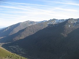
50:General view of the range
43:
36:
488:Serra dos Ancares (León)
476:Serra dos Ancares (León)
464:Serra dos Ancares (Lugo)
452:Serra dos Ancares (Lugo)
438:UNESCO Biosphere Reserve
352:(1,969 m). The smaller
330:autonomous communities
607:Sierra de los Ancares
537:Sierra de los Ancares
294:Sierra de los Ancares
38:Sierra de los Ancares
314:Cantabrian Mountains
104:42.76806°N 6.89806°W
548:Urugallo cantábrico
100: /
542:2011-09-06 at the
109:42.76806; -6.89806
56:Highest point
298:Sierra de Ancares
286:Serra dos Ancares
282:
281:
174:Location in Spain
167:Serra dos Ancares
31:Serra dos Ancares
16:(Redirected from
649:
584:
579:
573:
572:
570:
568:
557:
551:
534:
528:
521:
485:
473:
461:
449:
428:province of León
338:Castile and León
296:, also known as
241:Variscan orogeny
219:
200:Castile and León
162:
161:
155:
115:
114:
112:
111:
110:
105:
101:
98:
97:
96:
93:
48:
27:
21:
657:
656:
652:
651:
650:
648:
647:
646:
622:Galician Massif
612:
611:
593:
588:
587:
580:
576:
566:
564:
561:"Os Ancares..."
559:
558:
554:
544:Wayback Machine
535:
531:
522:
518:
513:
496:
489:
486:
477:
474:
465:
462:
453:
450:
436:was declared a
420:
354:Serra do Courel
326:
306:Galician Massif
224:Galician Massif
217:
194:
179:
178:
177:
176:
175:
172:
171:
170:
169:
163:
108:
106:
102:
99:
94:
91:
89:
87:
86:
51:
23:
22:
15:
12:
11:
5:
655:
653:
645:
644:
639:
634:
629:
624:
614:
613:
610:
609:
604:
599:
592:
591:External links
589:
586:
585:
574:
552:
529:
515:
514:
512:
509:
508:
507:
502:
495:
492:
491:
490:
487:
480:
478:
475:
468:
466:
463:
456:
454:
451:
444:
419:
416:
365:European alder
348:(1,935 m) and
325:
322:
308:in north-west
302:mountain range
280:
279:
262:
256:
255:
250:
244:
243:
238:
232:
231:
227:
226:
221:
213:
212:
207:
203:
202:
185:
181:
180:
173:
165:
164:
157:
156:
150:
149:
148:
147:
146:
143:
142:
138:
137:
134:
130:
129:
126:
122:
121:
117:
116:
84:
78:
77:
74:
68:
67:
62:
58:
57:
53:
52:
49:
41:
40:
34:
33:
24:
14:
13:
10:
9:
6:
4:
3:
2:
654:
643:
640:
638:
635:
633:
630:
628:
625:
623:
620:
619:
617:
608:
605:
603:
600:
598:
595:
594:
590:
583:
578:
575:
562:
556:
553:
549:
545:
541:
538:
533:
530:
526:
520:
517:
510:
506:
503:
501:
498:
497:
493:
484:
479:
472:
467:
460:
455:
448:
443:
441:
439:
435:
431:
429:
425:
417:
415:
413:
412:
406:
400:
398:
394:
390:
386:
382:
378:
374:
370:
366:
362:
357:
355:
351:
347:
343:
339:
335:
331:
323:
321:
319:
315:
311:
307:
303:
299:
295:
291:
287:
278:
274:
270:
266:
263:
261:
257:
254:
251:
249:
245:
242:
239:
237:
233:
228:
225:
222:
220:
214:
211:
208:
204:
201:
197:
196:León Province
193:
189:
188:Lugo Province
186:
182:
168:
154:
144:
139:
135:
131:
127:
123:
118:
113:
85:
83:
79:
75:
73:
69:
66:
63:
59:
54:
47:
42:
39:
35:
32:
28:
19:
577:
565:. Retrieved
555:
547:
532:
524:
519:
433:
432:
421:
408:
401:
385:common holly
377:common hazel
358:
327:
297:
293:
285:
283:
260:Type of rock
218:Parent range
166:
37:
30:
500:Los Ancares
248:Age of rock
107: /
82:Coordinates
616:Categories
511:References
505:Os Ancares
393:tree heath
350:Miravalles
253:Ordovician
120:Dimensions
92:42°46′05″N
389:brushland
346:Mustallar
324:Geography
277:quartzite
273:sandstone
269:limestone
141:Geography
95:6°53′53″W
72:Elevation
540:Archived
494:See also
369:chestnut
318:Asturias
184:Location
567:19 July
426:in the
418:Ecology
405:palloza
397:juniper
334:Galicia
304:of the
300:) is a
290:Spanish
236:Orogeny
230:Geology
206:Country
192:Galicia
18:Ancares
563:UNESCO
361:willow
125:Length
411:teito
409:casa
391:with
342:Cuiña
310:Spain
265:Slate
210:Spain
133:Width
65:Cuiña
569:2016
395:and
383:and
363:and
336:and
284:The
61:Peak
407:or
381:oak
373:ash
332:of
316:in
618::
546:,
430:.
399:.
379:,
375:,
371:,
320:.
292::
275:,
271:,
267:,
198:,
190:,
571:.
288:(
20:)
Text is available under the Creative Commons Attribution-ShareAlike License. Additional terms may apply.