34:
50:
147:
139:
57:
188:
The current size of the estate is 80 acres or 30 hectares. The property, which is largely left undeveloped, is owned by the
Lawaetz family who purchased the land in the 1960s. The northern boundary is the main road, and the southern boundary is the Caribbean sea. To the west, there is a residential
195:
Historically, the "Chemin Royal" one of the first roads build by the French traversed the
Balembouche Estate and crossed the river at the mouth. This was back then the easiest place to cross since the river is in a deep canyon. From this river is also derived the historic Balembouche aqueduct, a
199:
Since 2019, the aqueduct has been dry. Discussions are ongoing with the authorities and neighbours to restore the flow of water to the local farmers and ecosystems. Crops and livestock raised the estate include cattle, coconuts, breadfruit, papaya and organic vegetables. The estate also has an
176:
The entire area where the original 500+ acre estate was historically located is sometimes still referred to as "Balembouche" by locals. However, this is misleading, since those new developments, including an area called "Parc Lane" are no longer or were never part of the original
Balembouche
196:
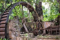
200-year-old waterway with a 30-ft dam, built in the late 1700s to power the waterwheel at the
Balembouche sugar mill. It is one of the only two remaining intact aqueducts on the island and has been maintained privately by the owners of Balenbouche estate for the past half a century.
180:
Historically, there are multiple spellings of the name, all referring to the same sugar plantation established by the French under colonial rule. Some alternate spellings include
Ballembouche, Balambouche, and Balenbouche. The name first appears on St. Lucia maps in the late 1760s.
184:
The exact origin of the name
Balembouche or Balenbouche is not known. Possible translations include "mouth of the whale" from the French "Baleine" and "bouche" and also "bullet or ball in the mouth" from the French phrase "bal en bouche."
161:) is the original name of a historic 18th-century sugar plantation, Balenbouche Estate, which is now a guesthouse, designated heritage site and organic farm on the island of
257:
33:
49:
81:
189:
development. The eastern boundary of the estate is the
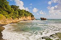
Balembouche River, which ends at the Balembouche Bay (Anse Balembouche).
377:
234:
229:
192:
Archeological remains at
Balembouche Estate include Amerindian artifacts and petroglyphs along the Balembouche River.
356:
125:
113:
217:
305:
213:
209:
130:
146:
371:
162:
118:
138:
96:
83:
200:
abundance of flora and fauna, including over 30 documented bird species.
344:
287:
166:
16:
Region, populated place, and plantation in
Laborie District Saint Lucia
170:
208:
Balembouche is also a second-order administrative division of
332:
165:. It is located on the south west coast of the island, near
124:
112:
24:
220:, and Balembouche Rocks in Laborie District.
8:
21:
282:
280:
278:
212:with a population of 16. There is also a
145:
137:
246:
111:
76:
42:
30:
252:
250:
123:
7:
56:
14:
55:
48:
32:
1:
235:List of rivers of Saint Lucia
230:List of cities in Saint Lucia
19:Place in Laborie, Saint Lucia
394:
313:Government of Saint Lucia
77:
43:
31:
288:"History of Balembouche"
69:Location in Saint Lucia
151:
150:Balembouche sugar mill
143:
149:
141:
97:13.75750°N 61.02722°W
378:Towns in Saint Lucia
357:"Balenbouche Estate"
102:13.75750; -61.02722
93: /
292:Balenbouche Estate
152:
144:
38:Balenbouche Estate
214:Balembouche River
136:
135:
385:
364:
352:
340:
324:
323:
321:
319:
310:
306:"Map of Laborie"
302:
296:
295:
284:
273:
272:
270:
268:
254:
210:Laborie District
108:
107:
105:
104:
103:
98:
94:
91:
90:
89:
86:
59:
58:
52:
36:
22:
393:
392:
388:
387:
386:
384:
383:
382:
368:
367:
355:
343:
331:
328:
327:
317:
315:
308:
304:
303:
299:
286:
285:
276:
266:
264:
256:
255:
248:
243:
226:
218:Balembouche Bay
206:
142:Balembouche Bay
101:
99:
95:
92:
87:
84:
82:
80:
79:
73:
72:
71:
70:
67:
66:
65:
64:
60:
39:
27:
20:
17:
12:
11:
5:
391:
389:
381:
380:
370:
369:
366:
365:
361:Open Green Map
353:
341:
326:
325:
297:
274:
245:
244:
242:
239:
238:
237:
232:
225:
222:
205:
202:
134:
133:
128:
122:
121:
116:
110:
109:
75:
74:
68:
62:
61:
54:
53:
47:
46:
45:
44:
41:
40:
37:
29:
28:
25:
18:
15:
13:
10:
9:
6:
4:
3:
2:
390:
379:
376:
375:
373:
362:
358:
354:
350:
346:
342:
338:
334:
333:"Balenbouche"
330:
329:
314:
307:
301:
298:
293:
289:
283:
281:
279:
275:
263:
259:
258:"Balembouche"
253:
251:
247:
240:
236:
233:
231:
228:
227:
223:
221:
219:
215:
211:
203:
201:
197:
193:
190:
186:
182:
178:
174:
172:
168:
164:
160:
157:(also called
156:
148:
140:
132:
129:
127:
120:
117:
115:
106:
78:Coordinates:
51:
35:
23:
360:
348:
336:
316:. Retrieved
312:
300:
291:
265:. Retrieved
261:
207:
198:
194:
191:
187:
183:
179:
177:plantation.
175:
158:
154:
153:
349:Balenbouche
337:Balenbouche
204:Other sites
163:Saint Lucia
159:Balenbouche
155:Balembouche
119:Saint Lucia
100: /
63:Balembouche
26:Balembouche
318:August 13,
267:August 13,
241:References
88:61°01′38″W
85:13°45′27″N
345:"History"
372:Category
262:GeoNames
224:See also
167:Bongalo
131:Laborie
126:Quarter
114:Country
309:(PDF)
171:Piaye
320:2021
269:2021
169:and
374::
359:.
347:.
335:.
311:.
290:.
277:^
260:.
249:^
216:,
173:.
363:.
351:.
339:.
322:.
294:.
271:.
Text is available under the Creative Commons Attribution-ShareAlike License. Additional terms may apply.


