434:
31:
404:. Baxterley Hall was built by John Glover in 1548, and demolished in 1849. It is thought that the original village site was built up around the church, quite some distance away from the current village and was mainly a centre for agricultural dwellings and working. The opening of the mine resulted in a gradual migration of the labour force some 2 miles or so down the road, so that nowadays there are just a few isolated cottages and houses close to the church and the majority of the village has effectively relocated to its present position.
47:
54:
236:
780:
887:
788:
276:
140:
430:
of the church. the mine closed in 1989 and remained derelict for many years until the remaining pit buildings on the Main Road were refurbished and converted into offices.
260:
636:
284:
97:
935:
222:
414:
was the major employer in the area, from its opening in 1850, to its closure in 1989. It was the site of one of the worst pit disasters in the
748:
46:
253:
1014:
248:
1009:
581:
320:
860:
302:
265:
210:
176:
756:
549:
312:
744:
90:
30:
433:
708:
377:
373:
82:
969:
609:
605:
307:
190:
696:
632:
557:
478:
466:. In 2010 the figure was up to 3.3 crimes per head. The most common type of crime is anti-social behaviour.
418:, where a coal dust explosion in 1882 lead to the deaths of 32 men, including the owner, William Dugdale of
166:
537:
and 18% describe themselves as non-religious with less than 1% of people describing themselves as other.
621:
498:
943:
723:
is a small grass-strip airfield with a single runway located to the west of village. It hosts several
752:
640:
577:
553:
510:
494:
486:
122:
835:
530:
455:
241:
716:
664:
613:
475:
463:
361:
158:
130:
760:
385:
585:
538:
215:
704:
617:
573:
526:
490:
451:
407:
864:
684:
624:
569:
522:
447:
683:
is half of the original winding wheel from the mine, mounted on a plinth. The nearest
1003:
668:
419:
401:
810:
703:. The village has 2 bus stops along Main road served by route 777, and the nearest
672:
644:
601:
365:
357:
148:
106:
67:
656:
568:
There has never been any educational establishments in the village. The nearest
740:
700:
660:
628:
589:
542:
381:
335:
322:
736:
724:
720:
534:
200:
552:, it is about 1.7 miles from the village and the nearest village to it is
506:
502:
482:
423:
415:
411:
965:
712:
545:
459:
369:
182:
446:
In 2009 there was an average of 2.2 crimes per 1,000 people for the
481:
trust area. The village does not have its own doctor's surgery or
458:, and during the same period there were 5 crimes per head for the
432:
397:
910:
680:
427:
676:
994:
513:. Out of hours GP services are also based at George Eliot.
861:"Crime Mapping — Warwickshire Police Safer Neighbourhoods"
604:
in its own Right. The village was originally part of the
679:. Outside the front of The Rose and next to the village
667:. The Postal Town is Atherstone. The nearest police and
376:, it had a population of 335, reducing to 328 at the
275:
259:
247:
235:
221:
209:
199:
189:
175:
157:
139:
121:
105:
89:
77:
23:
426:to those who lost their lives in the pit in the
612:it became part of the newly formed district of
616:. Inside North Warwickshire it is part of the
936:"Warwickshire Police Force - Police Stations"
8:
811:"The Baddesley Baxterley Pit Explosion 1882"
663:. Water and sewage services are provided by
911:"Kingsbury & Baxterley Group Home Page"
655:The village does not have any takeaways or
20:
380:. The village is about two miles west of
772:
274:
230:
198:
174:
88:
27:
749:Hits Radio Coventry & Warwickshire
396:Baxterley has been in existence since
972:from the original on 1 September 2018
258:
246:
234:
220:
208:
188:
156:
138:
120:
7:
437:Memorial to Baxterley Pit Disaster
400:times but is not mentioned in the
14:
560:and Baxterley Group of churches.
511:Accident and Emergency Department
388:'s national distribution centre.
53:
886:Sillitoe, Neil (14 April 2008).
755:. The village is covered by the
659:, with the nearest one being in
52:
45:
29:
785:Neighbourhood.statistics.gov.uk
745:BBC Coventry & Warwickshire
743:Recorder. Local radio includes
637:North Warwickshire constituency
781:"Civil Parish population 2011"
671:are in Atherstone. There is a
572:are in the nearby villages of
1:
489:'s surgeries can be found in
695:Baxterley lies close to the
815:Baddesleypitexplosion.co.uk
719:(15 miles). Baxterley
533:82% describe themselves as
91:OS grid reference
18:Human settlement in England
1031:
1015:Coal mines in Warwickshire
940:www.warwickshire.police.uk
890:. Neighbourhood Statistics
888:"Detect browser settings"
739:covering the area is the
610:Local Government Act 1972
606:Atherstone Rural District
293:
271:
231:
40:
28:
1010:Villages in Warwickshire
474:The village lies in the
356:is a small village and
438:
211:Postcode district
966:"Baxterley Aerodrome"
727:throughout the year.
550:Diocese of Birmingham
499:George Eliot Hospital
436:
753:Capital Mid-Counties
635:. It is part of the
608:. In 1974 under the
556:. It is part of the
505:is the area's local
372:. According to the
191:Sovereign state
915:Kingbaxgroup.org.uk
840:Mine-explorer.co.uk
791:on 23 December 2015
332: /
995:Official Home Page
687:is in Atherstone.
675:known as the Rose
665:Severn Trent Water
614:North Warwickshire
541:, a church in the
476:North Warwickshire
464:North Warwickshire
439:
362:North Warwickshire
285:North Warwickshire
277:UK Parliament
223:Dialling code
131:North Warwickshire
946:on 11 August 2003
867:on 5 October 2010
761:BBC West Midlands
600:The village is a
386:Jaguar Land Rover
351:
350:
141:Shire county
1022:
982:
981:
979:
977:
962:
956:
955:
953:
951:
942:. Archived from
932:
926:
925:
923:
921:
906:
900:
899:
897:
895:
883:
877:
876:
874:
872:
863:. Archived from
857:
851:
850:
848:
846:
832:
826:
825:
823:
821:
807:
801:
800:
798:
796:
787:. Archived from
777:
643:is Conservative
639:and the current
586:secondary school
539:Baxterley Church
347:
346:
344:
343:
342:
337:
336:52.570°N 1.591°W
333:
330:
329:
328:
325:
299:
185:
101:
100:
66:Location within
56:
55:
49:
33:
21:
1030:
1029:
1025:
1024:
1023:
1021:
1020:
1019:
1000:
999:
991:
986:
985:
975:
973:
964:
963:
959:
949:
947:
934:
933:
929:
919:
917:
909:Young, Carole.
908:
907:
903:
893:
891:
885:
884:
880:
870:
868:
859:
858:
854:
844:
842:
836:"Mine Explorer"
834:
833:
829:
819:
817:
809:
808:
804:
794:
792:
779:
778:
774:
769:
733:
705:railway station
693:
653:
651:Public Services
618:Baddesley Ensor
598:
588:is situated in
574:Baddesley Ensor
570:primary schools
566:
519:
491:Baddesley Ensor
472:
444:
394:
384:and is home to
340:
338:
334:
331:
326:
323:
321:
319:
318:
317:
297:
289:
181:
171:
153:
135:
117:
96:
95:
73:
72:
71:
70:
64:
63:
62:
61:
57:
36:
19:
12:
11:
5:
1028:
1026:
1018:
1017:
1012:
1002:
1001:
998:
997:
990:
989:External links
987:
984:
983:
957:
927:
901:
878:
852:
827:
802:
771:
770:
768:
765:
732:
729:
711:. The nearest
692:
689:
685:Leisure centre
652:
649:
631:are currently
597:
594:
584:. The nearest
565:
562:
518:
515:
485:. The nearest
471:
468:
443:
440:
422:. There is a
410:and Baxterley
393:
390:
349:
348:
341:52.570; -1.591
316:
315:
310:
305:
300:
298:List of places
294:
291:
290:
288:
287:
281:
279:
273:
272:
269:
268:
263:
257:
256:
251:
245:
244:
239:
233:
232:
229:
228:
225:
219:
218:
213:
207:
206:
203:
197:
196:
195:United Kingdom
193:
187:
186:
179:
173:
172:
170:
169:
163:
161:
155:
154:
152:
151:
145:
143:
137:
136:
134:
133:
127:
125:
119:
118:
116:
115:
111:
109:
103:
102:
93:
87:
86:
79:
75:
74:
65:
59:
58:
51:
50:
44:
43:
42:
41:
38:
37:
34:
26:
25:
17:
13:
10:
9:
6:
4:
3:
2:
1027:
1016:
1013:
1011:
1008:
1007:
1005:
996:
993:
992:
988:
971:
967:
961:
958:
945:
941:
937:
931:
928:
916:
912:
905:
902:
889:
882:
879:
866:
862:
856:
853:
841:
837:
831:
828:
816:
812:
806:
803:
790:
786:
782:
776:
773:
766:
764:
762:
758:
754:
750:
746:
742:
738:
730:
728:
726:
722:
718:
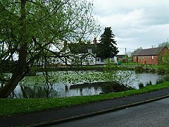
714:
710:
706:
702:
698:
690:
688:
686:
682:
678:
674:
670:
669:fire stations
666:
662:
658:
650:
648:
646:
642:
638:
634:
633:Conservatives
630:
626:
623:
619:
615:
611:
607:
603:
595:
593:
591:
587:
583:
579:
575:
571:
563:
561:
559:
555:
551:
547:
544:
540:
536:
532:
528:
524:
516:
514:
512:
508:
504:
500:
496:
492:
488:
484:
480:
477:
469:
467:
465:
461:
457:
453:
449:
441:
435:
431:
429:
425:
421:
420:Merevale Hall
417:
413:
409:
405:
403:
402:Domesday Book
399:
391:
389:
387:
383:
379:
375:
371:
367:
363:
359:
355:
345:
314:
311:
309:
306:
304:
301:
296:
295:
292:
286:
283:
282:
280:
278:
270:
267:
266:West Midlands
264:
262:
255:
252:
250:
243:
240:
238:
226:
224:
217:
214:
212:
204:
202:
194:
192:
184:
180:
178:
168:
167:West Midlands
165:
164:
162:
160:
150:
147:
146:
144:
142:
132:
129:
128:
126:
124:
113:
112:
110:
108:
104:
99:
94:
92:
84:
80:
76:
69:
48:
39:
32:
22:
16:
974:. Retrieved
960:
948:. Retrieved
944:the original
939:
930:
918:. Retrieved
914:
904:
892:. Retrieved
881:
869:. Retrieved
865:the original
855:
843:. Retrieved
839:
830:
818:. Retrieved
814:
805:
793:. Retrieved
789:the original
784:
775:
763:TV regions.
734:
694:
673:Public House
654:
645:Craig Tracey
602:Civil Parish
599:
567:
520:
509:. It has an
473:
445:
406:
395:
366:Warwickshire
364:district of
358:civil parish
353:
352:
313:Warwickshire
254:Warwickshire
242:Warwickshire
149:Warwickshire
107:Civil parish
68:Warwickshire
35:The Rose Inn
15:
795:23 December
757:Central ITV
657:restaurants
629:councillors
378:2011 Census
374:2001 Census
339: /
1004:Categories
950:17 January
767:References
741:Atherstone
735:The local
717:Birmingham
709:Atherstone
701:Atherstone
661:Atherstone
596:Governance
590:Atherstone
543:Polesworth
382:Atherstone
324:52°34′12″N
205:Atherstone
98:SP 278 970
81:328 (
78:Population
737:newspaper
725:air shows
721:Aerodrome
691:Transport
564:Education
558:Kingsbury
535:Christian
527:Baddesley
452:Baddesley
408:Baddesley
354:Baxterley
327:1°35′28″W
261:Ambulance
201:Post town
114:Baxterley
60:Baxterley
24:Baxterley
970:Archived
920:13 March
894:13 March
871:13 March
845:13 March
820:13 March
582:Wood End
554:Wood End
521:For the
517:Religion
507:hospital
503:Nuneaton
483:pharmacy
424:memorial
416:Midlands
412:Colliery
123:District
713:airport
627:, both
622:Grendon
548:of the
546:Deanery
531:Grendon
460:borough
456:Grendon
392:History
370:England
360:in the
308:England
183:England
177:Country
976:20 May
578:Hurley
497:. The
495:Hurley
470:Health
237:Police
159:Region
731:Media
699:near
442:Crime
398:Saxon
227:01827
978:2019
952:2022
922:2017
896:2017
873:2017
847:2017
822:2017
797:2015
759:and
751:and
681:pond
625:ward
620:and
580:and
529:and
523:ward
493:and
454:and
448:ward
428:nave
249:Fire
83:2011
715:is
707:is
677:Inn
525:of
501:at
479:NHS
462:of
450:of
368:in
216:CV9
1006::
968:.
938:.
913:.
838:.
813:.
783:.
747:,
697:A5
647:.
641:MP
592:.
576:,
487:GP
303:UK
980:.
954:.
924:.
898:.
875:.
849:.
824:.
799:.
85:)
Text is available under the Creative Commons Attribution-ShareAlike License. Additional terms may apply.