161:
177:
699:
718:
734:
36:
184:
482:. There is one service a day in each direction, including Sundays. On Friday evenings an extra journey operates from Ballina. Onward bus and rail connections are available at Ballina.
579:
761:
684:
698:
717:
667:
176:
160:
446:
1944, and the landing was delayed by a day because of an inclement forecast. Blackrock
Lighthouse lies 12 miles (19 km) offshore on
218:
119:
733:
635:
57:
100:
53:
72:
756:
79:
390:
46:
357:. The 16 km (9.9 mi) long and 8 km (5.0 mi) wide bay is bounded on its western side by the
86:
602:
451:
447:
68:
479:
431:
354:
439:
495:
661:
610:
555:
530:
285:
491:
435:
358:
499:
93:
766:
518:
416:
386:
342:
330:
150:
750:
739:
724:
467:
642:
580:"US honour for 98-year-old woman whose Mayo weather report changed D-Day landing"
709:
510:
475:
471:
350:
203:
35:
614:
233:
220:
503:
463:
442:. It is famously the lighthouse the Allies used for the weather forecast on
402:
370:
366:
17:
517:, which teaches watersports and other sports through the medium of the
412:. Blacksod Bay is wide at its mouth and is a safe place for anchorage.
374:
362:
603:"Maureen Flavin Sweeney Dies at 100; Her Weather Report Delayed D-Day"
398:
394:
705:
550:
443:
420:
346:
438:. It was built from locally cut granite taken from the quarry at
250:
434:, which was completed in 1862, occupies the southern end of the
409:
406:
385:
Blacksod Bay, which contains many little islets, opens to the
338:
29:
521:
to schoolchildren and adventure groups from across
Ireland.
389:. The granite found in this area as most of the rest of the
454:
lies off the northwest tip of the Mullet
Peninsula.
514:
308:
300:
292:
283:
279:
271:
263:
259:
249:
210:
199:
136:
60:. Unsourced material may be challenged and removed.
506:off the North Mayo coastline leave from Blacksod.
415:At its northern end, Blacksod Bay is connected to
211:
8:
142:
27:Bay of the Atlantic Ocean in Erris, Ireland
462:Bus Éireann route 446 links the area with
133:
490:Throughout the summer, boat trips to the
120:Learn how and when to remove this message
509:Elly Bay is a popular location for many
762:Ramsar sites in the Republic of Ireland
694:
542:
742:at Claggan beach, part of Blacksod Bay
666:: CS1 maint: archived copy as title (
659:
365:Parish, which extends southwards from
307:
299:
291:
282:
7:
183:
58:adding citations to reliable sources
25:
578:O'Riordan, Ellen (21 June 2021).
732:
716:
697:
182:
175:
159:
34:
515:Colaiste Uisce Adventure Centre
270:
262:
45:needs additional citations for
601:Traub, Alex (2 January 2024).
502:are reputed to be buried, and
1:
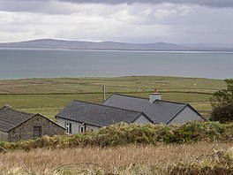
551:"Blacksod Bay and Broadhaven"
198:
165:Bay from the Mullet Peninsula
405:is covered with fairly flat
361:. Its eastern side includes
296:Blacksod Bay and Broadhaven
783:
267:16 kilometres (10 mi)
704:A sail boat at Elly Bay,
558:Sites Information Service
320:
316:
170:
158:
141:
452:Eagle Island lighthouse
334:
143:
275:8 km (5 mi)
513:and the location of
393:consists of ancient
54:improve this article
757:Bays of County Mayo
432:Blacksod Lighthouse
423:through Belmullet.
419:by an 18th-century
335:Cuan an Fhóid Duibh
230: /
191:Location in Ireland
144:Cuan an Fhóid Duibh
723:Blacksod Bay with
607:The New York Times
309:Reference no.
531:Wild Atlantic Way
324:
323:
251:Ocean/sea sources
130:
129:
122:
104:
16:(Redirected from
774:
736:
720:
701:
672:
671:
665:
657:
655:
653:
647:
641:. Archived from
640:
632:
626:
625:
623:
621:
598:
592:
591:
589:
587:
575:
569:
568:
566:
564:
547:
492:Inishkea Islands
448:Blackrock Island
436:Mullet Peninsula
359:Mullet Peninsula
252:
245:
244:
242:
241:
240:
235:
231:
228:
227:
226:
223:
213:
186:
185:
179:
163:
154:
146:
134:
125:
118:
114:
111:
105:
103:
62:
38:
30:
21:
782:
781:
777:
776:
775:
773:
772:
771:
747:
746:
743:
737:
728:
721:
712:
702:
693:
681:
676:
675:
658:
651:
649:
645:
638:
636:"Archived copy"
634:
633:
629:
619:
617:
600:
599:
595:
585:
583:
577:
576:
572:
562:
560:
549:
548:
544:
539:
527:
500:Children of Lir
488:
460:
429:
383:
288:
238:
236:
234:54.12°N 10.03°W
232:
229:
224:
221:
219:
217:
216:
195:
194:
193:
192:
189:
188:
187:
166:
148:
126:
115:
109:
106:
63:
61:
51:
39:
28:
23:
22:
15:
12:
11:
5:
780:
778:
770:
769:
764:
759:
749:
748:
745:
744:
738:
731:
729:
722:
715:
713:
703:
696:
692:
689:
688:
687:
680:
679:External links
677:
674:
673:
648:on 17 May 2012
627:
593:
570:
541:
540:
538:
535:
534:
533:
526:
523:
519:Irish language
487:
484:
459:
456:
428:
425:
417:Broadhaven Bay
387:Atlantic Ocean
382:
379:
343:Atlantic Ocean
322:
321:
318:
317:
314:
313:
310:
306:
305:
302:
298:
297:
294:
290:
289:
286:Ramsar Wetland
284:
281:
280:
277:
276:
273:
269:
268:
265:
261:
260:
257:
256:
255:Atlantic Ocean
253:
247:
246:
214:
208:
207:
201:
197:
196:
190:
181:
180:
174:
173:
172:
171:
168:
167:
164:
156:
155:
139:
138:
128:
127:
69:"Blacksod Bay"
42:
40:
33:
26:
24:
14:
13:
10:
9:
6:
4:
3:
2:
779:
768:
765:
763:
760:
758:
755:
754:
752:
741:
740:Kite boarding
735:
730:
726:
725:Achill Island
719:
714:
711:
707:
700:
695:
690:
686:
683:
682:
678:
669:
663:
644:
637:
631:
628:
616:
612:
608:
604:
597:
594:
582:. Irish Times
581:
574:
571:
559:
557:
552:
546:
543:
536:
532:
529:
528:
524:
522:
520:
516:
512:
507:
505:
501:
497:
493:
485:
483:
481:
477:
473:
469:
465:
457:
455:
453:
449:
445:
441:
437:
433:
426:
424:
422:
418:
413:
411:
408:
404:
401:. The Mullet
400:
396:
392:
388:
380:
378:
376:
372:
368:
364:
360:
356:
352:
348:
344:
340:
336:
332:
328:
319:
315:
311:
303:
295:
293:Official name
287:
278:
274:
266:
258:
254:
248:
243:
239:54.12; -10.03
215:
209:
205:
202:
178:
169:
162:
157:
152:
145:
140:
135:
132:
124:
121:
113:
110:November 2009
102:
99:
95:
92:
88:
85:
81:
78:
74:
71: –
70:
66:
65:Find sources:
59:
55:
49:
48:
43:This article
41:
37:
32:
31:
19:
727:to the south
650:. Retrieved
643:the original
630:
618:. Retrieved
606:
596:
584:. Retrieved
573:
561:. Retrieved
554:
545:
508:
498:, where the
489:
468:Bangor Erris
461:
430:
414:
384:
327:Blacksod Bay
326:
325:
137:Blacksod Bay
131:
116:
107:
97:
90:
83:
76:
64:
52:Please help
47:verification
44:
710:County Mayo
511:watersports
476:Crossmolina
472:Bellacorick
440:Termon Hill
427:Lighthouses
351:County Mayo
304:7 June 1996
264:Max. length
237: /
212:Coordinates
204:County Mayo
751:Categories
537:References
496:Inishglora
301:Designated
272:Max. width
80:newspapers
685:Depth map
620:6 January
615:0362-4331
504:Duvillaun
464:Belmullet
458:Transport
403:peninsula
391:substrate
381:Geography
371:Gweesalia
367:Belmullet
206:, Ireland
662:cite web
563:25 April
525:See also
369:towards
349:, north
200:Location
18:Blacksod
691:Gallery
586:21 June
486:Tourism
480:Ballina
375:Doohoma
363:Kiltane
355:Ireland
341:of the
337:) is a
225:10°02′W
222:54°07′N
94:scholar
652:6 June
613:
556:Ramsar
399:schist
395:gneiss
147:
96:
89:
82:
75:
67:
767:Erris
706:Erris
646:(PDF)
639:(PDF)
444:D-day
421:canal
410:dunes
347:Erris
331:Irish
151:Irish
101:JSTOR
87:books
668:link
654:2012
622:2024
611:ISSN
588:2021
565:2018
478:and
407:sand
397:and
373:and
73:news
345:in
339:bay
312:844
56:by
753::
708:,
664:}}
660:{{
609:.
605:.
553:.
494:,
474:,
470:,
466:,
450:.
377:.
353:,
333::
670:)
656:.
624:.
590:.
567:.
329:(
153:)
149:(
123:)
117:(
112:)
108:(
98:·
91:·
84:·
77:·
50:.
20:)
Text is available under the Creative Commons Attribution-ShareAlike License. Additional terms may apply.