29:
361:
124:
117:
424:
415:
406:
397:
388:
379:
370:
670:
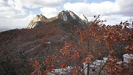
310:. There are three major peaks, Baegundae 836.5 meters (2,744 ft), Insubong 810.5 meters (2,659 ft), Mangyeongdae 787.0 meters (2,582.0 ft). Because of its height and the fact that it borders a considerable portion of the city, Bukhansan is a major landmark visible from most city districts. The name "Bukhansan" means "mountain north of
344:
Since 2002 there has been a movement to revert the name of
Bukhansan to Samgaksan. For many years up until now, the three main peaks of the park have collectively been called "Bukhansan"; however, the original collective name of these three peaks was Samgaksan, meaning "three-horned mountain." The
556:
336:, which was formed in 1983, are renowned for birdwatching, hiking and rockclimbing. Bukhansan attracts a large number of hikers; around 5 million per year.
73:
710:
651:
496:
638:
526:
116:
700:
321:
Bukhansan is the highest mountain within Seoul city boundaries. Apart from
Bukhansan, there are seven other mountains including
449:
by author Hong Sun-soo and artist Im Gak-hyuck is a fictional work based on the mountain rescue team working in this mountain.
234:
560:
685:
423:
66:
705:
349:
District Office in Seoul is leading a petition to have the central government change the name back to the original.
500:
59:
360:
28:
583:
333:
248:
674:
648:
504:
172:
54:
635:
534:
311:
655:
642:
271:
468:
680:
315:
694:
163:
414:
405:
396:
387:
378:
369:
314:", referring to the fact that it is the northern border of the city. During the
307:
151:
136:
346:
88:
75:
607:
322:
629:
669:
326:
299:
440:
239:
224:
221:
218:
443:
194:
44:
473:
303:
210:
318:
era, the peaks marked the extreme northern boundary of Seoul.
623:
253:
497:"Bukhansan National Park (Dobong) (북한산국립공원(도봉 지구))"
247:
233:
209:
193:
188:
162:
157:
147:
104:
65:
53:
43:
38:
21:
649:Bukhansan National Park (북한산국립공원) by Visit Korea
329:that are over 600 metres high within the city.
636:Best Hiking Mountains in Seoul by Visit Korea
559:. Korea National Park Service. Archived from
8:
332:Popular throughout the year, Bukhansan, and
216:
200:
279:
18:
463:
461:
457:
356:
624:Seoul Hiking Tourism Center(Bukhansan)
16:Highest mountain in Seoul, South Korea
178:Bukansan National Park Visitor Center
7:
582:Park, Jin-woo (박진우) (2007-06-14).
14:
123:
668:
527:"Best Hiking Mountains in Seoul"
422:
413:
404:
395:
386:
377:
368:
359:
122:
115:
27:
711:Mountains of Gyeonggi Province
217:
201:
1:
686:National parks of South Korea
302:on the northern periphery of
176:(북한산우이) then walk 2.29km to
49:836.5 m (2,744 ft)
33:The three peaks of Bukhansan
557:"Introduction to Bukhansan"
254:
240:
727:
501:Korea Tourism Organization
275:
261:
184:
109:
26:
701:Mountains of South Korea
584:"북한산, 본래 이름 '삼각산' 되찾아야"
334:Bukhansan National Park
630:Bukhansan Hiking Club
429:A shrine in Bukhansan
677:at Wikimedia Commons
507:on 28 September 2013
435:Films and literature
235:Revised Romanization
173:Bukhansan Ui Station
89:37.6608°N 126.9933°E
563:on 17 November 2015
85: /
706:Mountains of Seoul
654:2013-09-28 at the
641:2012-01-23 at the
537:on 23 January 2012
289:North Han Mountain
60:Mountains of Korea
39:Highest point
673:Media related to
265:
264:
249:McCune–Reischauer
180:(북한산국립공원백운탐방지원센터)
94:37.6608; 126.9933
718:
672:
612:
611:
604:
598:
597:
595:
594:
579:
573:
572:
570:
568:
553:
547:
546:
544:
542:
533:. Archived from
523:
517:
516:
514:
512:
503:. Archived from
493:
487:
486:
484:
482:
469:"Bukhansan(북한산)"
465:
426:
417:
408:
399:
390:
381:
372:
363:
293:
290:
287:
284:
281:
277:
257:
243:
228:
227:
204:
203:
166:
126:
125:
119:
100:
99:
97:
96:
95:
90:
86:
83:
82:
81:
78:
31:
19:
726:
725:
721:
720:
719:
717:
716:
715:
691:
690:
665:
656:Wayback Machine
643:Wayback Machine
620:
615:
606:
605:
601:
592:
590:
581:
580:
576:
566:
564:
555:
554:
550:
540:
538:
525:
524:
520:
510:
508:
495:
494:
490:
480:
478:
467:
466:
459:
455:
437:
430:
427:
418:
409:
400:
391:
382:
373:
364:
355:
342:
296:Bukhan Mountain
291:
288:
285:
282:
229:
205:
164:
143:
142:
141:
140:
139:
134:
133:
132:
131:
127:
93:
91:
87:
84:
79:
76:
74:
72:
71:
34:
17:
12:
11:
5:
724:
722:
714:
713:
708:
703:
693:
692:
689:
688:
683:
681:Bukhansanseong
678:
664:
661:
660:
659:
646:
633:
627:
619:
618:External links
616:
614:
613:
599:
588:Sports Hankook
574:
548:
518:
488:
456:
454:
451:
436:
433:
432:
431:
428:
421:
419:
412:
410:
403:
401:
394:
392:
385:
383:
376:
374:
367:
365:
358:
354:
351:
341:
338:
263:
262:
259:
258:
251:
245:
244:
237:
231:
230:
215:
213:
207:
206:
199:
197:
191:
190:
186:
185:
182:
181:
168:
160:
159:
155:
154:
149:
145:
144:
135:
129:
128:
121:
120:
114:
113:
112:
111:
110:
107:
106:
102:
101:
69:
63:
62:
57:
51:
50:
47:
41:
40:
36:
35:
32:
24:
23:
15:
13:
10:
9:
6:
4:
3:
2:
723:
712:
709:
707:
704:
702:
699:
698:
696:
687:
684:
682:
679:
676:
671:
667:
666:
662:
657:
653:
650:
647:
644:
640:
637:
634:
631:
628:
625:
622:
621:
617:
609:
603:
600:
589:
585:
578:
575:
562:
558:
552:
549:
536:
532:
528:
522:
519:
506:
502:
498:
492:
489:
476:
475:
470:
464:
462:
458:
452:
450:
448:
445:
442:
434:
425:
420:
416:
411:
407:
402:
398:
393:
389:
384:
380:
375:
371:
366:
362:
357:
352:
350:
348:
339:
337:
335:
330:
328:
324:
319:
317:
313:
309:
305:
301:
297:
273:
269:
260:
256:
252:
250:
246:
242:
238:
236:
232:
226:
223:
220:
214:
212:
208:
198:
196:
192:
187:
183:
179:
175:
174:
169:
167:
165:Easiest route
161:
156:
153:
150:
146:
138:
118:
108:
103:
98:
70:
68:
64:
61:
58:
56:
52:
48:
46:
42:
37:
30:
25:
20:
602:
591:. Retrieved
587:
577:
565:. Retrieved
561:the original
551:
539:. Retrieved
535:the original
530:
521:
509:. Retrieved
505:the original
491:
479:. Retrieved
472:
446:
438:
345:head of the
343:
331:
320:
295:
267:
266:
177:
171:
567:27 February
541:17 November
531:Visit Korea
511:27 February
481:27 February
477:(in Korean)
308:South Korea
189:Korean name
152:South Korea
137:South Korea
92: /
80:126°59′36″E
67:Coordinates
695:Categories
593:2007-06-21
453:References
347:Gangbuk-gu
77:37°39′39″N
675:Bukhansan
323:Dobongsan
312:Han River
268:Bukhansan
255:Pukhansan
241:Bukhansan
130:Bukhansan
105:Geography
45:Elevation
22:Bukhansan
663:See also
652:Archived
639:Archived
327:Suraksan
300:mountain
158:Climbing
441:webtoon
353:Gallery
298:, is a
283:
148:Country
55:Listing
658:, 2012
645:, 2012
632:, 2014
626:, 2023
608:"PEAK"
444:manhwa
316:Joseon
294:), or
272:Korean
195:Hangul
474:Naver
439:Daum
304:Seoul
211:Hanja
170:from
569:2015
543:2012
513:2015
483:2015
447:PEAK
340:Name
325:and
280:lit.
276:북한산
202:북한산
697::
586:.
529:.
499:.
471:.
460:^
306:,
278:,
274::
610:.
596:.
571:.
545:.
515:.
485:.
292:'
286:'
270:(
225:山
222:漢
219:北
Text is available under the Creative Commons Attribution-ShareAlike License. Additional terms may apply.