70:
63:
341:– rectangular timber structure have been found to the southwest. They were discovered during examination of an adjacent later stone building. This appears unique in Ireland and Britain and is still the subject of analysis. It may have served as a medieval corn-drying kiln, but the presence of the partial remains of three people, dumped at its entrance and dating to the 15th or 16th century, presents a mystery.
350:
47:
276:, around a metre wide. There are also two visible structures. Structure A is located next to the north wall of the fort. It is rectangular with the long axis running east to west, measuring roughly 10m by 5m. Structure B is next to the west wall of the fort, measuring around 7.5m by 5m internally. Its north wall is part of the dividing wall.
316:
Findings indicate that the inhabitants not only consumed relatively high-status items but were also manufacturing them at the site (pin-making mould). There seems to have been precious metal work going on and there are signs of ironworking (slag, possible anvil position). The archaeological report
312:
conducted in connection with an archaeological excavation in the summer of 2007, the ringfort mostly dates from the early 10th to mid-12th century. Occupation deposits indicate the fort was used from around the early 10th century to the early 13th century. The later structure A with a rectangular
268:
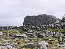
Caherconnell features a circular drystone enclosure wall with a diameter of 42 metres. Walls are up to 3 metres thick and up to 3 metres high. The amount of loose stones suggests an original height of around one extra metre. The wall is made of local limestone. The entrance gap is located to the
478:
313:
outline was likely built between the early 15th and mid-17th century. It is not certain whether the cashel was continuously inhabited or temporarily abandoned in the 14th century.
935:
513:
930:
360:
From summer 2010, Caherconnell has been home to an archaeological field school where students can learn archaeological techniques from leading archaeologists.
877:
330:
The inhabitants of the 15th/16th century were not from the main branch of the family, which had moved to
Glensleade Castle, about 3 km to the north.
891:
940:
62:
506:
114:
599:
437:
499:
323:
in the Burren". The relatively long use - well into modern times - is attributed to the fact that the area, controlled by the
401:
317:
also notes that: "The imposing morphology of the site, its walls and diameter, sets it apart from the vast majority of
745:
674:
357:
The ringfort is open to the public. The owner runs a visitor centre with an audio visual presentation and café.
659:
327:
family, was not directly affected by Anglo-Norman influences but remained culturally Gaelic for a long time.
872:
740:
639:
587:
473:
807:
694:
582:
767:
225:
828:
777:
689:
624:
522:
309:
287:
229:
792:
604:
433:
403:
Caherconnell Cashel, Caherconnell, Carron, Co. Clare, Final
Archaeological Excavation Report
787:
735:
649:
253:
797:
715:
684:
634:
629:
619:
291:
245:
818:
556:
324:
854:
849:
669:
546:
212:, meaning 'Conall's stone ringfort') is an exceptionally well-preserved medieval stone
205:
924:
859:
782:
750:
699:
664:
273:
756:
730:
679:
654:
609:
577:
551:
526:
491:
241:
221:
720:
644:
541:
349:
844:
823:
725:
593:
338:
280:
217:
94:
906:
893:
129:
116:
802:
762:
334:
249:
90:
17:
46:
813:
572:
213:
164:
149:
772:
375:
279:
Some additional structures surround the ringfort. The existence of a
348:
257:
495:
486:
487:
283:
has been surmised but nothing definite has been found.
463:, Vol. 35, p. 20-25, August 2011, ISSN 0332-088X.
457:
Caherconnel, Co. Clare - A Cashel of
Continuous Use?
837:
708:
565:
534:
300:that remained in use until a relatively late date.
272:Inside the enclosure are the remains of a dividing
240:Caherconnell lies west of the R480 road connecting
191:
183:
175:
170:
160:
155:
145:
108:
100:
85:
474:Caherconnell at the Clare County Library website
27:Medieval stone ringfort in County Clare, Ireland
400:Hull, Graham; Comber, Michelle (24 July 2008),
69:
507:
8:
878:Category:Tourist attractions in County Clare
260:limestone and the land is used for pasture.
32:
318:
295:
248:in the townland of Caherconnell, parish of
51:Part of the wall of Caherconnell Stone Fort
514:
500:
492:
286:The fort shows numerous similarities with
45:
31:
936:Buildings and structures in County Clare
395:
393:
391:
389:
387:
385:
383:
368:
228:. It lies about 1 km south of the
423:
421:
419:
417:
415:
256:, County Clare. The local geology is
7:
931:Archaeological sites in County Clare
480:Excavations in Caherconnell townland
482:in: Burren Landscape and Settlement
600:Burren and Cliffs of Moher Geopark
25:
941:Forts in the Republic of Ireland
68:
61:
376:Placenames Database of Ireland
1:
957:
333:Postholes of an earlier –
868:
675:Parknabinnia (wedge tomb)
56:
44:
37:
660:Gleninsheen (wedge tomb)
907:53.040750°N 9.1391722°W
763:Kilfenora Burren Centre
615:Caherconnell Stone Fort
566:The Burren and environs
33:Caherconnell Stone Fort
746:Dysert O'Dea Monastery
354:
319:
296:
209:
912:53.040750; -9.1391722
873:Category:County Clare
741:Dromore, County Clare
640:Creevagh (wedge tomb)
588:Ballyallaban ringfort
432:. The Collins Press.
428:Carthy, Hugh (2011).
352:
130:53.04075°N 9.139172°W
709:Rest of County Clare
695:Shanmuckinish Castle
583:Ballinalacken Castle
77:Shown within Ireland
903: /
768:Kilfenora Cathedral
216:in region known as
135:53.04075; -9.139172
126: /
34:
829:West Clare Railway
778:Killaloe Cathedral
721:Carrigaholt Castle
690:Poulnabrone dolmen
625:Cahermore ringfort
535:Ennis and environs
430:Burren Archaeology
355:
310:Radiocarbon dating
288:Cahermore ringfort
230:Poulnabrone dolmen
192:Public access
886:
885:
793:Latoon fairy bush
753:(Scattery Island)
605:Burren Smokehouse
353:Caherconnell Fort
199:
198:
16:(Redirected from
948:
918:
917:
915:
914:
913:
908:
904:
901:
900:
899:
896:
788:Knappogue Castle
736:Dromoland Castle
650:Doonagore Castle
516:
509:
502:
493:
444:
443:
425:
410:
409:
408:
397:
378:
373:
322:
299:
254:Barony of Burren
210:Cathair Chonaill
141:
140:
138:
137:
136:
131:
127:
124:
123:
122:
119:
72:
71:
65:
49:
39:Cathair Chonaill
35:
21:
956:
955:
951:
950:
949:
947:
946:
945:
921:
920:
911:
909:
905:
902:
897:
894:
892:
890:
889:
887:
882:
864:
833:
798:Leamaneh Castle
716:Bunratty Castle
704:
685:Poulawack Cairn
635:Corcomroe Abbey
630:Cliffs of Moher
620:Cahermacnaghten
561:
530:
520:
470:
461:The Other Clare
452:
450:Further reading
447:
440:
427:
426:
413:
406:
399:
398:
381:
374:
370:
366:
347:
306:
292:Cahermacnaghten
266:
246:Leamaneh Castle
238:
134:
132:
128:
125:
120:
117:
115:
113:
112:
81:
80:
79:
78:
75:
74:
73:
52:
40:
28:
23:
22:
15:
12:
11:
5:
954:
952:
944:
943:
938:
933:
923:
922:
884:
883:
881:
880:
875:
869:
866:
865:
863:
862:
857:
855:Lough Derg Way
852:
850:East Clare Way
847:
841:
839:
838:Walking trails
835:
834:
832:
831:
826:
821:
816:
811:
805:
800:
795:
790:
785:
780:
775:
770:
765:
760:
754:
748:
743:
738:
733:
728:
723:
718:
712:
710:
706:
705:
703:
702:
697:
692:
687:
682:
677:
672:
670:Newtown Castle
667:
662:
657:
652:
647:
642:
637:
632:
627:
622:
617:
612:
607:
602:
597:
590:
585:
580:
575:
569:
567:
563:
562:
560:
559:
554:
549:
547:Cois na hAbhna
544:
538:
536:
532:
531:
521:
519:
518:
511:
504:
496:
490:
489:
484:
476:
469:
468:External links
466:
465:
464:
451:
448:
446:
445:
438:
411:
379:
367:
365:
362:
346:
343:
305:
302:
265:
262:
237:
234:
197:
196:
193:
189:
188:
185:
181:
180:
177:
176:Archaeologists
173:
172:
168:
167:
162:
158:
157:
153:
152:
147:
143:
142:
110:
106:
105:
102:
98:
97:
87:
83:
82:
76:
67:
66:
60:
59:
58:
57:
54:
53:
50:
42:
41:
38:
26:
24:
14:
13:
10:
9:
6:
4:
3:
2:
953:
942:
939:
937:
934:
932:
929:
928:
926:
919:
916:
879:
876:
874:
871:
870:
867:
861:
860:Mid Clare Way
858:
856:
853:
851:
848:
846:
843:
842:
840:
836:
830:
827:
825:
822:
820:
817:
815:
812:
809:
806:
804:
801:
799:
796:
794:
791:
789:
786:
784:
783:Killone Abbey
781:
779:
776:
774:
771:
769:
766:
764:
761:
759:(Holy Island)
758:
755:
752:
751:Inis Cathaigh
749:
747:
744:
742:
739:
737:
734:
732:
729:
727:
724:
722:
719:
717:
714:
713:
711:
707:
701:
700:Temple Cronan
698:
696:
693:
691:
688:
686:
683:
681:
678:
676:
673:
671:
668:
666:
663:
661:
658:
656:
653:
651:
648:
646:
643:
641:
638:
636:
633:
631:
628:
626:
623:
621:
618:
616:
613:
611:
608:
606:
603:
601:
598:
596:
595:
591:
589:
586:
584:
581:
579:
576:
574:
571:
570:
568:
564:
558:
555:
553:
550:
548:
545:
543:
540:
539:
537:
533:
528:
524:
517:
512:
510:
505:
503:
498:
497:
494:
488:
485:
483:
481:
477:
475:
472:
471:
467:
462:
458:
454:
453:
449:
441:
439:9781848891050
435:
431:
424:
422:
420:
418:
416:
412:
405:
404:
396:
394:
392:
390:
388:
386:
384:
380:
377:
372:
369:
363:
361:
358:
351:
344:
342:
340:
336:
331:
328:
326:
321:
314:
311:
308:According to
303:
301:
298:
293:
289:
284:
282:
277:
275:
274:drystone wall
270:
263:
261:
259:
255:
251:
247:
243:
235:
233:
231:
227:
223:
219:
215:
211:
207:
203:
194:
190:
186:
182:
178:
174:
169:
166:
163:
159:
154:
151:
148:
144:
139:
111:
107:
103:
99:
96:
92:
88:
84:
64:
55:
48:
43:
36:
30:
19:
888:
819:O'Dea Castle
757:Inis Cealtra
731:Craggaunowen
680:Pollnagollum
655:Dough Castle
614:
610:Cahercommaun
592:
578:Aillwee Cave
557:Glór Theatre
552:Ennis Friary
527:County Clare
479:
460:
456:
455:Comber, M.,
429:
402:
371:
359:
356:
332:
329:
315:
307:
294:, two other
285:
278:
271:
267:
242:Ballyvaughan
239:
222:County Clare
202:Caherconnell
201:
200:
29:
18:Caherconnell
910: /
898:9°8′21.02″W
895:53°2′26.7″N
645:Doolin Cave
542:Clare Abbey
304:Excavations
264:Description
179:Graham Hull
133: /
109:Coordinates
925:Categories
845:Burren Way
824:Quin Abbey
808:Lough Derg
726:Castlebawn
665:Hag's Head
594:The Burren
364:References
339:Bronze Age
281:souterrain
218:the Burren
171:Site notes
118:53°02′27″N
95:the Burren
89:Parish of
803:Loop Head
529:, Ireland
335:Neolithic
325:O'Loghlen
250:Kilcorney
184:Ownership
121:9°08′21″W
91:Kilcorney
814:Mooghaun
573:Ailladie
236:Location
214:ringfort
165:Medieval
150:Ringfort
86:Location
523:Tourism
320:cashels
297:cashels
226:Ireland
187:private
161:Periods
156:History
104:Ireland
810:(part)
773:Kilkee
459:, in:
436:
269:east.
101:Region
407:(PDF)
345:Today
258:karst
206:Irish
434:ISBN
290:and
244:and
146:Type
525:in
337:or
195:yes
927::
414:^
382:^
252:,
232:.
224:,
220:,
208::
93:,
515:e
508:t
501:v
442:.
204:(
20:)
Text is available under the Creative Commons Attribution-ShareAlike License. Additional terms may apply.