56:
237:
40:
63:
270:
and then flows past
Hebiweri Mountain. Below the Sidonkrutu-rapids it joins with the Adampada, which drains most of the eastern slope of the Bakhuys range. Below the Langa rapids, the river bends to the east and above the
259:), the Left Coppename, and the middle Coppename, which has its sources in the western and central parts of the north side of the Wilhelmina mountains and from the south east region of the
55:
366:
160:
382:
251:. Its tributaries are the Right Coppename (which originates on the northeast slope of the Wilhelmina range,
91:
248:
129:
267:
272:
252:
217:
294:
225:
100:
362:
310:
260:
345:
96:
333:
290:
283:
146:
314:
236:
200:
376:
306:
240:
275:
is joined by the
Tangimama, which rises in the northern foothills of the Emmaketen.
289:
After being joined by the Kwama, the
Coppename flows further north and passes the
140:
39:
329:
175:
162:
321:
279:
256:
298:
213:
84:
17:
361:. Amsterdam u. Brussel 1977, B.V. Uitgeversmaatschappij Argus Elsevier;
302:
286:, are a tourist attraction, which can be reached by a small airplanes.
221:
325:
235:
305:. Once in the old coastal plain, the Coppename is joined by the
220:, forming part of the boundary between the districts of
266:
The three branches of the
Coppename unite above the
196:
191:
152:
139:
123:
115:
106:
90:
80:
75:
32:
27:
River in
Coronie & Saramacca District, Suriname
8:
278:The Raleigh Falls, together with the nearby
357:C.F.A. Bruijning und J. Voorhoeve (red.):
62:
29:
7:
243:over the Coppename river at Bitagron
216:(South America) in the district of
247:The Coppename river begins in the
25:
336:unite and flow together into the
61:
54:
38:
255:, and the western parts of the
313:between the Coppename and the
154: • coordinates
1:
107:Physical characteristics
332:join it. The Coppename and
125: • location
399:
359:Encyclopedie van Suriname
135:
111:
49:
37:
244:
239:
249:Wilhelmina Mountains
130:Wilhelmina Mountains
192:Basin features
172: /
383:Rivers of Suriname
245:
176:5.8321°N 55.9448°W
101:Saramacca District
284:Van Stockum range
261:Bakhuys Mountains
206:
205:
16:(Redirected from
390:
346:Coppename Bridge
334:Saramacca Rivers
309:, which forms a
187:
186:
184:
183:
182:
181:5.8321; -55.9448
177:
173:
170:
169:
168:
165:
126:
65:
64:
58:
42:
30:
21:
398:
397:
393:
392:
391:
389:
388:
387:
373:
372:
354:
342:
315:Nickerie Rivers
234:
180:
178:
174:
171:
166:
163:
161:
159:
158:
155:
147:Saramacca River
124:
71:
70:
69:
68:
67:
66:
45:
44:Coppename River
33:Coppename River
28:
23:
22:
15:
12:
11:
5:
396:
394:
386:
385:
375:
374:
371:
370:
353:
350:
349:
348:
341:
338:
280:Voltz Mountain
268:Tonckens Falls
233:
230:
212:is a river in
204:
203:
201:Atlantic Ocean
198:
194:
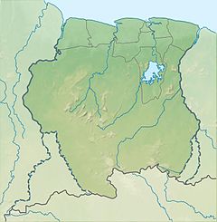
193:
189:
188:
156:
153:
150:
149:
143:
137:
136:
133:
132:
127:
121:
120:
117:
113:
112:
109:
108:
104:
103:
94:
88:
87:
82:
78:
77:
73:
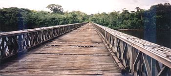
72:
60:
59:
53:
52:
51:
50:
47:
46:
43:
35:
34:
26:
24:
14:
13:
10:
9:
6:
4:
3:
2:
395:
384:
381:
380:
378:
368:
367:90-10-01842-3
364:
360:
356:
355:
351:
347:
344:
343:
339:
337:
335:
331:
327:
323:
320:Finally, the
318:
316:
312:
308:
307:Wayambo River
304:
300:
296:
292:
287:
285:
281:
276:
274:
273:Raleigh Falls
269:
264:
262:
258:
254:
250:
242:
241:Bailey bridge
238:
231:
229:
227:
223:
219:
215:
211:
202:
199:
195:
190:
185:
157:
151:
148:
144:
142:
138:
134:
131:
128:
122:
118:
114:
110:
105:
102:
98:
95:
93:
89:
86:
83:
79:
74:
57:
48:
41:
36:
31:
19:
358:
319:
293:villages of
288:
277:
265:
246:
209:
207:
322:tributaries
311:bifurcation
295:Kaaimanston
197:Progression
179: /
145:confluence
352:References
330:Coesewijne
218:Sipaliwini
167:55°56′41″W
257:Emmaketen
253:Tafelberg
226:Saramacca
210:Coppename
164:5°49′56″N
18:Coppename
377:Category
340:See also
299:Bitagron
282:and the
214:Suriname
92:District
85:Suriname
76:Location
303:Heidoti
222:Coronie
97:Coronie
81:Country
365:
326:Tibiti
324:, the
291:Maroon
232:Course
119:
116:Source
99:&
141:Mouth
363:ISBN
328:and
301:and
224:and
208:The
379::
317:.
297:,
263:.
228:.
369:.
20:)
Text is available under the Creative Commons Attribution-ShareAlike License. Additional terms may apply.