60:
169:
35:
44:
206:
635:
67:
300:) in shallow pits dug in the sand. During the second period, tombs have been documented where the corpses (not preserved) lay surrounded by pots, probably containing food and alcoholic beverages. The deceased were interred with their adornments (collars, bracelets and anklets) and a few personal possessions (knives and adzes).
303:
When
Portuguese sailors arrived in the Mino Estuary in 1471, they noted that the islands in the area were mainly unpopulated. They named Corisco after 'lightning', due to the gales they experienced around the island. After more than three centuries of abandonment, when it was sporadically visited by
295:
During the Iron Age (50 BC - 1400 AD) and before the arrival of the
Portuguese, the island was densely settled. The most important evidence of human occupation comes from the area of Nandá, near the eastern coast, where dozens of prehistoric burials have been excavated. These burials belong to two
446:
Ayán Vila, Xurxo; González-Ruibal, Alfredo; García-Rodríguez, Sonia; Otero Vilariño, Carlos; Picornell
Gelabert, Llorenç; Sánchez-Elipe Lorente, Manuel; Trigo, Mario; Bayre, Francesca; Valenciano Mañé, Alba; Porto Tenreiro, Yolanda (June 15, 2011).
296:
different periods: Early Iron Age (50 BC - 450 AD) and Middle Iron Age (1000-1150 AD). During the first period, the islanders deposited bundles of human bones and iron implements (axes, bracelets, spears, spoons,
612:
Colección de apuntes preliminares sobre la lengua benga: ó sea, Intrucción a una gramática de este idióma que se habla en la isla de
Corisco, pueblos de su bahía é islas adyacentes
432:
659:
669:
59:
308:. They arrived during the second half of the 18th century attracted by the prospects of trade with the Europeans. The island was later acquired by
664:
654:
495:
190:
583:
95:
411:
391:
348:
183:
313:
279:
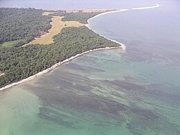
word for lightning, has an area of 14 km (5 sq mi), and its highest point is 35 m (115 ft)
510:
347:
paid little attention to
Corisco. In the early part of the 20th century it was part of the administration of
571:
34:
639:
284:
25:
355:
were issued under that name. It became an integral part of
Equatorial Guinea upon independence.
321:
317:
579:
491:
485:
426:
379:
371:
333:
264:
174:
329:
553:
Mary
Henrietta Kingsley; Albert Carl Ludwig Gotthilf Günther; William Forsell Kirby (1897).
456:
232:
280:
554:
378:
because of the perceived value of the oil. In
February 2003, Gabonese Defence Minister
344:
337:
325:
648:
367:
352:
297:
305:
610:
591:
535:
359:
268:
526:
X. Ayán Vila et al., Arqueología en el
Estuario del Muni (Guinea Ecuatorial).
448:
110:
97:
224:
634:
460:
276:
511:"Gabon-Equatorial Guinea: UN mediates dispute over Corisco Bay islands"
537:
Fragmentos de un diario de viajes de exploración en la zona de
Corisco
260:
236:
43:
375:
309:
272:
211:
363:
576:
Small is not always beautiful: The Story of Equatorial Guinea
556:
Travels in West Africa: Congo Francais, Corisco and Cameroons
324:, but due to rivalries on the island, Bonkoro II moved to
449:"Arqueología en el Estuario del Muni (Guinea Ecuatorial)"
382:
visited the islands and re-stated Gabon's claim to them.
593:
Crónica de las Islas de Fernando Póo, Corisco y Annobon
414:. 2015-05-11. Archived from the original on 2015-05-11
320:. Bonkoro I died in 1846 and was succeeded by his son
374:
began prospecting in 1981. The area is disputed with
267:, located 29 km (18 mi) southwest of the
223:
218:
196:
158:
150:
142:
134:
126:
89:
84:
24:
362:have become of interest in recent years for their
283:. The most important settlement on the island is
479:
477:
431:: CS1 maint: bot: original URL status unknown (
484:Mark P. Leone; Jocelyn E. Knauf (27 May 2015).
312:in 1843, as a result of an arrangement made by
304:European sailors, Corisco was settled by the
8:
19:
42:
33:
18:
660:Territorial disputes of Equatorial Guinea
412:"Isla de Corsico | Marine World Database"
403:
332:ruled in Corisco 1848 to 1858, his son
275:. Corisco, whose name derives from the
487:Historical Archaeologies of Capitalism
424:
358:Corisco and the surrounding waters of
336:taking over, and meeting the explorer
271:estuary that defines the border with
7:
14:
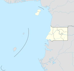
48:Corisco Island and Elobey Islands
633:
609:Francisco Salvadó y Cos (1891).
204:
167:
130:14 km (5.4 sq mi)
65:
58:
66:
670:Equatorial Guinea–Gabon border
1:
665:Territorial disputes of Gabon
590:José Muñoz y Gaviria (1870).
534:Manuel Iradier Bulfi (1878).
392:Corisco International Airport
655:Islands of Equatorial Guinea
470:– via digital.csic.es.
349:Elobey, Annobon, and Corisco
615:. Impr. de A. Pérez Cubrull
366:prospects. A consortium of
16:Island of Equatorial Guinea
686:
513:, IRIN, January 23, 2004.
490:. Springer. p. 430.
201:
189:
182:
163:
53:
41:
32:
314:Juan José Lerena y Barry
146:5 km (3.1 mi)
138:6 km (3.7 mi)
528:Revista de Arqueología
219:Additional information
642:at Wikimedia Commons
461:10.13039/501100003767
380:Ali-Ben Bongo Ondimba
111:0.91500°N 9.32000°E
107: /
21:
572:Max Liniger-Goumaz
151:Highest point
638:Media related to
497:978-3-319-12760-6
265:Equatorial Guinea
246:
245:
175:Equatorial Guinea
677:
637:
624:
622:
620:
605:
603:
601:
568:
566:
564:
549:
547:
545:
514:
508:
502:
501:
481:
472:
471:
469:
467:
443:
437:
436:
430:
422:
420:
419:
408:
343:In general, the
316:with Benga king
210:
208:
207:
173:
171:
170:
122:
121:
119:
118:
117:
116:0.91500; 9.32000
112:
108:
105:
104:
103:
100:
69:
68:
62:
46:
37:
22:
685:
684:
680:
679:
678:
676:
675:
674:
645:
644:
631:
618:
616:
608:
599:
597:
589:
562:
560:
552:
543:
541:
533:
523:
521:Further reading
518:
517:
509:
505:
498:
483:
482:
475:
465:
463:
453:digital.csic.es
445:
444:
440:
423:
417:
415:
410:
409:
405:
400:
388:
293:
281:above sea level
242:
214:
205:
203:
178:
168:
166:
115:
113:
109:
106:
101:
98:
96:
94:
93:
80:
79:
78:
77:
76:
75:
74:
70:
49:
28:
26:Disputed island
17:
12:
11:
5:
683:
681:
673:
672:
667:
662:
657:
647:
646:
630:
629:External links
627:
626:
625:
606:
587:
569:
550:
531:
522:
519:
516:
515:
503:
496:
473:
438:
402:
401:
399:
396:
395:
394:
387:
384:
353:postage stamps
340:in the 1870s.
338:Manuel Iradier
292:
289:
244:
243:
241:
240:
229:
227:
221:
220:
216:
215:
202:
199:
198:
194:
193:
191:Insular Region
187:
186:
180:
179:
164:
161:
160:
159:Administration
156:
155:
152:
148:
147:
144:
140:
139:
136:
132:
131:
128:
124:
123:
91:
87:
86:
82:
81:
72:
71:
64:
63:
57:
56:
55:
54:
51:
50:
47:
39:
38:
30:
29:
15:
13:
10:
9:
6:
4:
3:
2:
682:
671:
668:
666:
663:
661:
658:
656:
653:
652:
650:
643:
641:
636:
628:
614:
613:
607:
595:
594:
588:
585:
584:0-389-20861-2
581:
577:
573:
570:
558:
557:
551:
539:
538:
532:
530:, 362: 24–33.
529:
525:
524:
520:
512:
507:
504:
499:
493:
489:
488:
480:
478:
474:
462:
458:
454:
450:
442:
439:
434:
428:
413:
407:
404:
397:
393:
390:
389:
385:
383:
381:
377:
373:
369:
368:Elf Aquitaine
365:
361:
356:
354:
350:
346:
341:
339:
335:
331:
327:
323:
319:
315:
311:
307:
301:
299:
298:iron currency
290:
288:
286:
282:
278:
274:
270:
266:
262:
259:, is a small
258:
254:
250:
238:
234:
231:
230:
228:
226:
222:
217:
213:
200:
195:
192:
188:
185:
181:
177:
176:
162:
157:
153:
149:
145:
141:
137:
133:
129:
125:
120:
92:
88:
83:
61:
52:
45:
40:
36:
31:
27:
23:
632:
617:. Retrieved
611:
598:. Retrieved
592:
586:) p. 7.
575:
561:. Retrieved
555:
542:. Retrieved
536:
527:
506:
486:
466:November 15,
464:. Retrieved
452:
441:
416:. Retrieved
406:
357:
342:
306:Benga people
302:
294:
256:
252:
248:
247:
165:
559:. Macmillan
360:Corisco Bay
114: /
90:Coordinates
649:Categories
540:. Fortanet
418:2022-08-01
398:References
322:Bonkoro II
277:Portuguese
197:Claimed by
619:25 August
600:25 August
563:25 August
544:25 August
318:Bonkoro I
225:Time zone
102:9°19′12″E
99:0°54′54″N
85:Geography
427:cite web
386:See also
372:Petrogab
334:Munga II
326:São Tomé
269:Río Muni
640:Corisco
596:. Rubio
578:(1989,
345:Spanish
330:Munga I
291:History
249:Corisco
184:Litoral
73:Corisco
20:Corisco
582:
494:
351:, and
328:, and
261:island
257:Mandyi
253:Mandj,
209:
172:
135:Length
376:Gabon
310:Spain
273:Gabon
237:UTC+1
212:Gabon
143:Width
621:2012
602:2012
580:ISBN
565:2012
546:2012
492:ISBN
468:2022
433:link
370:and
285:Gobe
154:35 m
127:Area
457:doi
364:oil
263:of
255:or
233:WAT
651::
574:,
476:^
455:.
451:.
429:}}
425:{{
287:.
251:,
623:.
604:.
567:.
548:.
500:.
459::
435:)
421:.
239:)
235:(
Text is available under the Creative Commons Attribution-ShareAlike License. Additional terms may apply.