48:
61:
305:. During that period, over 150 objects were built in Crkvice, including military training grounds, hotel, tennis courts, bowling alley, football pitch with stands for 1,000 spectators, cinema, church, bakery, hospital, post office, stables, and even a funicular. During the Austro-Hungarian period, Crkvice had up to 10,000 inhabitants. Crkvice bakery was the largest in Balkans at the time, having produced 24 tons of bread per day.
132:
266:
68:
376:
of Bura type appear in winter and are most severe in the Bay of Risan. Gusts reach 250 km/h and can lead to a significant fall of temperatures in several hours with freezing events problematic for most of the
Mediterranean cultures. Jugo is a warm humid wind and is important as it brings heavy
334:
Annual rainfall at
Crkvice is around 5,100 millimetres (200 in). Like most of the Mediterranean Sea, precipitation occurs principally during the winter, but in the higher mountains there is a secondary summer maximum. August is frequently completely dry, leading to
493:
421:
327:
belt. While summers are hot and sunny, autumn, winter and spring are rainy seasons. A peculiarity of the littoral
Dinarids is the precipitation regime as the settlements of
596:
581:
301:), were built by the Austro-Hungarian soldiers in the first half of the 19th century, and represented the furthest fortification towards the border with
353:, is a remarkable indicator of this seasonality. Most of the time it is inactive but after heavy rain a remarkable waterfall appears 20 m above the
542:
47:
494:"Unveiling the hidden landscapes of Montenegro: The EU's work to preserve cultural heritage helps boost tourism in the Western Balkans"
60:
428:
92:
302:
194:
144:
586:
217:
249:. Despite the fact that it is nowadays virtually uninhabited, Crkvice was most notable the location of a large
202:
124:
229:
173:
591:
309:
270:
468:
346:
183:
149:
396:
294:
278:
250:
17:
518:
601:
373:
575:
321:
285:
region, Crkvice was used up as the base military camp. The fortifications, including
354:
386:
282:
234:
377:
rain. It appears throughout the year but is most frequent in autumn and spring.
365:
336:
324:
254:
238:
16:
This article is about the village in
Montenegro. For the village in Serbia, see
265:
242:
137:
557:
544:
107:
94:
164:
401:
391:
286:
246:
190:
169:
422:"Late Holocene Glacial History of Sólheimajökull, Southern Iceland"
350:
343:
328:
264:
369:
361:
342:
With a maximum discharge of 350 m³/s water one of the biggest
308:
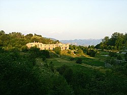
The monument dedicated to the victorious rebels of the 1869
331:
receive more precipitation than any others in Europe.
201:
180:
163:
155:
143:
123:
28:
364:are noteworthy for their ecological significance:
312:was put up in Crkvice on its centenary in 1969.
257:, when Montenegro regained control of the area.
253:military base which was active until the end of
269:Monument in Crkvice dedicated to rebels of the
8:
454:Crna Gora i Bokeljski ustanak 1869. godine
25:
413:
200:
162:
154:
122:
87:
53:
44:
597:Former populated places in the Balkans
469:"Rušenje katoličke crkve na Crkvicama"
245:, and the wettest inhabited place in
228:
179:
142:
7:
582:Military history of Austria-Hungary
14:
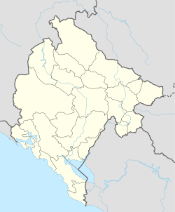
80:Location of Crkvice in Montenegro
130:
66:
59:
46:
67:
221:
1:
159:1,092 m (3,583 ft)
23:Village in Kotor, Montenegro
618:
15:
88:
54:
45:
38:
349:, the Sopot spring near
523:Encyclopædia Britannica
277:During the rule of the
230:[t͡sř̩kv̞it͡sɛ]
320:Crkvice is within the
274:
237:, on the outskirts of
268:
182: • Summer (
452:Tomislav Grgurević.
554: /
104: /
587:Kotor Municipality
310:Krivošije uprising
275:
271:Krivošije Uprising
233:) is a village in
558:42.567°N 18.633°E
211:
210:
108:42.567°N 18.633°E
609:
569:
568:
566:
565:
564:
559:
555:
552:
551:
550:
547:
534:
533:
531:
529:
515:
509:
508:
506:
504:
490:
484:
483:
481:
479:
464:
458:
457:
449:
443:
442:
440:
439:
433:
427:. Archived from
426:
418:
299:Crkvice Westfort
251:Austro-Hungarian
232:
227:
223:
218:Serbian Cyrillic
187:
136:
134:
133:
119:
118:
116:
115:
114:
109:
105:
102:
101:
100:
97:
70:
69:
63:
50:
26:
617:
616:
612:
611:
610:
608:
607:
606:
572:
571:
562:
560:
556:
553:
548:
545:
543:
541:
540:
538:
537:
527:
525:
517:
516:
512:
502:
500:
492:
491:
487:
477:
475:
466:
465:
461:
451:
450:
446:
437:
435:
431:
424:
420:
419:
415:
410:
383:
374:downslope winds
318:
291:Crkvice Ostfort
279:Austria-Hungary
263:
225:
181:
131:
129:
112:
110:
106:
103:
98:
95:
93:
91:
90:
84:
83:
82:
81:
78:
77:
76:
75:
71:
41:
34:
31:
24:
21:
18:Crkvice, Bojnik
12:
11:
5:
615:
613:
605:
604:
599:
594:
589:
584:
574:
573:
563:42.567; 18.633
536:
535:
510:
498:eeas.europa.eu
485:
459:
444:
412:
411:
409:
406:
405:
404:
399:
394:
389:
382:
379:
372:. Strong cold
317:
314:
262:
259:
209:
208:
205:
199:
198:
188:
178:
177:
167:
161:
160:
157:
153:
152:
147:
141:
140:
127:
121:
120:
113:42.567; 18.633
86:
85:
79:
73:
72:
65:
64:
58:
57:
56:
55:
52:
51:
43:
42:
39:
36:
35:
32:
29:
22:
13:
10:
9:
6:
4:
3:
2:
614:
603:
600:
598:
595:
593:
590:
588:
585:
583:
580:
579:
577:
570:
567:
524:
520:
514:
511:
499:
495:
489:
486:
474:
470:
467:Anton Belan.
463:
460:
455:
448:
445:
434:on 2014-03-20
430:
423:
417:
414:
407:
403:
400:
398:
397:Fort Stražnik
395:
393:
390:
388:
385:
384:
380:
378:
375:
371:
367:
363:
358:
356:
352:
348:
345:
340:
338:
332:
330:
326:
323:
322:Mediterranean
315:
313:
311:
306:
304:
300:
296:
295:Fort Stražnik
292:
288:
284:
280:
272:
267:
260:
258:
256:
252:
248:
244:
240:
236:
231:
219:
215:
206:
204:
196:
192:
189:
185:
175:
171:
168:
166:
158:
151:
148:
146:
139:
128:
126:
117:
89:Coordinates:
62:
49:
37:
27:
19:
539:
526:. Retrieved
522:
519:"Montenegro"
513:
501:. Retrieved
497:
488:
476:. Retrieved
472:
462:
453:
447:
436:. Retrieved
429:the original
416:
362:wind systems
359:
355:Bay of Kotor
341:
337:forest fires
333:
319:
307:
298:
290:
276:
213:
212:
145:Municipality
561: /
503:14 February
478:14 February
473:bokanews.me
325:subtropical
255:World War I
239:Mount Orjen
111: /
576:Categories
528:18 January
438:2012-09-07
408:References
303:Montenegro
243:Montenegro
226:pronounced
138:Montenegro
592:Krivošije
387:Krivošije
283:Krivošije
281:over the
235:Krivošije
203:Area code
165:Time zone
156:Elevation
402:Malov Do
392:Fort Kom
381:See also
287:Fort Kom
549:18°38′E
546:42°34′N
347:springs
316:Climate
261:History
222:Црквице
214:Crkvice
207:+382 32
125:Country
99:18°38′E
96:42°34′N
74:Crkvice
40:Village
33:Црквице
30:Crkvice
293:) and
273:(1869)
247:Europe
135:
602:Orjen
432:(PDF)
425:(PDF)
351:Risan
344:karst
329:Orjen
191:UTC+2
170:UTC+1
150:Kotor
530:2021
505:2018
480:2018
370:jugo
368:and
366:bora
360:Two
195:CEST
241:in
184:DST
174:CET
578::
521:.
496:.
471:.
357:.
339:.
224:,
220::
532:.
507:.
482:.
456:.
441:.
297:(
289:(
216:(
197:)
193:(
186:)
176:)
172:(
20:.
Text is available under the Creative Commons Attribution-ShareAlike License. Additional terms may apply.