301:
49:
325:
77:
443:
289:
313:
29:
84:
56:
259:. Since around 1960, Blomstølskardbreen on the southern end of Folgefonna has changed very little. Bondhusbreen and Buerbreen further north were growing in the 1990s, but have been retreating since the year 2000. The glacier is a famous tourist attraction. Most people who visit the town of
484:
362:
251:
The glacier is home to a summer skiing resort, located on its northern region. The largest outflow glaciers from
Folgefonna are Blomstølskardbreen,
48:
300:
324:
523:
421:
76:
133:
477:
288:
240:, with an area of 167 square kilometres (64 sq mi), making it the third largest glacier in the mainland of Norway.
503:
126:
470:
357:
312:
245:
387:
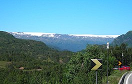
244:
In total, Folgefonna covers about 207 km (80 sq mi) (measured in 2006). On 14 May 2005,
237:
518:
508:
34:
417:
231:
225:
454:
513:
497:
279:
28:
442:
252:
260:
214:
210:
148:
135:
275:
264:
256:
198:
270:
The melt-water from this glacier is bottled at source to form the product
450:
202:
115:
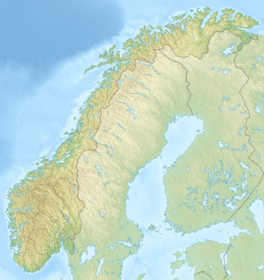
344:
meaning 'thin layer of snow' and the last element is the finite form of
209:. They are located on the Folgefonna peninsula in the municipalities of
194:
271:
206:
119:
248:
was established, protecting the glaciers and the surrounding areas.
218:
391:
234:, with an area of 11 square kilometres (4.2 sq mi)
228:, with an area of 26 square kilometres (10 sq mi)
458:
180:
172:
164:
125:
111:
103:
21:
274:. The melt-water also goes down the river from
348:meaning 'mass of snow, glacier made of snow'.
478:
8:
485:
471:
18:
363:List of mountains in Norway by prominence
294:Bondhusbreen - an offshoot of Folgefonna
374:
284:
193:is a collective term for three plateau
382:
380:
378:
7:
439:
437:
416:(in Norwegian). Nord4. p. 591.
457:. You can help Knowledge (XXG) by
83:
55:
14:
184:375 metres (1,230 ft) (max.)
441:
412:Brekke, Nils Georg, ed. (2008).
323:
311:
299:
287:
168:207 km (80 sq mi)
82:
75:
54:
47:
27:
33:Folgefonna seen from the road
1:
306:Looking down from the glacier
330:A closer view of the glacier
238:Søndre (southern) Folgefonna
226:Nordre (northern) Folgefonna
16:Glaciers in Vestland, Norway
318:Aerial view of the glaciers
232:Midtre (central) Folgefonna
540:
436:
414:Folgefonna og Fjordbygdene
358:List of glaciers in Norway
221:. The three glaciers are:
176:36 kilometres (22 mi)
263:usually take the walk to
41:
26:
524:Vestland geography stubs
267:(a part of Folgafonna).
246:Folgefonna National Park
63:Location of the glacier
453:location article is a
388:Store norske leksikon
340:The first element is
504:Glaciers of Vestland
66:Show map of Vestland
278:down into the lake
145: /
91:Folgefonna (Norway)
94:Show map of Norway
466:
465:
188:
187:
531:
487:
480:
473:
445:
438:
428:
427:
409:
403:
402:
400:
399:
384:
327:
315:
303:
291:
160:
159:
157:
156:
155:
150:
149:60.000°N 6.333°E
146:
143:
142:
141:
138:
107:Plateau glaciers
95:
86:
85:
79:
67:
58:
57:
51:
31:
19:
539:
538:
534:
533:
532:
530:
529:
528:
494:
493:
492:
491:
434:
432:
431:
424:
411:
410:
406:
397:
395:
386:
385:
376:
371:
354:
338:
331:
328:
319:
316:
307:
304:
295:
292:
153:
151:
147:
144:
139:
136:
134:
132:
131:
99:
98:
97:
96:
93:
92:
89:
88:
87:
70:
69:
68:
65:
64:
61:
60:
59:
37:
17:
12:
11:
5:
537:
535:
527:
526:
521:
516:
511:
506:
496:
495:
490:
489:
482:
475:
467:
464:
463:
446:
430:
429:
422:
404:
394:(in Norwegian)
373:
372:
370:
367:
366:
365:
360:
353:
350:
337:
334:
333:
332:
329:
322:
320:
317:
310:
308:
305:
298:
296:
293:
286:
242:
241:
235:
229:
186:
185:
182:
178:
177:
174:
170:
169:
166:
162:
161:
129:
123:
122:
113:
109:
108:
105:
101:
100:
90:
81:
80:
74:
73:
72:
71:
62:
53:
52:
46:
45:
44:
43:
42:
39:
38:
32:
24:
23:
15:
13:
10:
9:
6:
4:
3:
2:
536:
525:
522:
520:
517:
515:
512:
510:
507:
505:
502:
501:
499:
488:
483:
481:
476:
474:
469:
468:
462:
460:
456:
452:
447:
444:
440:
435:
425:
423:9788273260703
419:
415:
408:
405:
393:
389:
383:
381:
379:
375:
368:
364:
361:
359:
356:
355:
351:
349:
347:
343:
335:
326:
321:
314:
309:
302:
297:
290:
285:
283:
281:
280:Sandvinvatnet
277:
273:
268:
266:
262:
258:
254:
249:
247:
239:
236:
233:
230:
227:
224:
223:
222:
220:
216:
212:
208:
204:
200:
196:
192:
183:
179:
175:
171:
167:
163:
158:
154:60.000; 6.333
130:
128:
124:
121:
117:
114:
110:
106:
102:
78:
50:
40:
36:
30:
25:
20:
459:expanding it
448:
433:
413:
407:
396:. Retrieved
392:"Folgefonna"
345:
341:
339:
269:
253:Bondhusbreen
250:
243:
190:
189:
152: /
127:Coordinates
519:Kvinnherad
509:Ullensvang
498:Categories
398:2014-06-12
369:References
215:Kvinnherad
211:Ullensvang
201:region of
191:Folgefonna
22:Folgefonna
276:Buarbreen
265:Buarbreen
257:Buarbreen
199:Hardanger
181:Thickness
451:Vestland
352:See also
205:county,
203:Vestland
195:glaciers
116:Vestland
112:Location
197:in the
137:60°00′N
420:
272:Isklar
255:, and
217:, and
207:Norway
173:Length
140:6°20′E
120:Norway
449:This
342:folge
514:Etne
455:stub
418:ISBN
346:fonn
336:Name
261:Odda
219:Etne
165:Area
104:Type
35:E134
500::
390:.
377:^
282:.
213:,
118:,
486:e
479:t
472:v
461:.
426:.
401:.
Text is available under the Creative Commons Attribution-ShareAlike License. Additional terms may apply.