112:
96:
81:
738:
959:
71:
784:
56:
683:
119:
415:) characterized by hot summers and cold winters with heavy snowfall. The average annual temperature in Funahashi is 13.9 °C. The average annual rainfall is 2306 mm with September as the wettest month. The temperatures are highest on average in August, at around 26.4 °C, and lowest in January, at around 2.6 °C.
360:
of 952 inhabitants per square kilometre (2,470/sq mi). The total area of the town was 3.47 square kilometres (1.34 sq mi), making it the smallest municipality in Japan in terms of area .
111:
531:. The modern village of Funahashi was created with the establishment of the municipalities system on April 1, 1889. Funahashi is the only village left in
1025:
95:
996:
563:
Funahashi has one public elementary school and one public middle school operated by the village government. The village does not have a high school.
520:
143:
1020:
940:
577:
727:
409:
80:
904:
783:
989:
876:
929:
919:
854:
341:
219:
687:
70:
1015:
582:
55:
755:
405:
337:
982:
185:
175:
914:
909:
737:
551:) was traditionally the mainstay of the local economy; however, the village has increasingly become a
924:
765:
720:
202:
423:
Per
Japanese census data, the population of Funahashi has more than doubled over the past 30 years.
269:
628:
813:
357:
214:
958:
741:
552:
532:
528:
519:
345:
207:
46:
869:
864:
391:
386:
828:
713:
194:
190:
966:
833:
808:
381:
288:
1009:
881:
823:
818:
773:
750:
705:
666:
838:
798:
548:
613:
655:
353:
158:
145:
260:
17:
886:
682:
523:
Map of
Nakaniikawa district in Meiji era, with Funahashi labelled no. 16
695:
544:
308:
265:
803:
518:
349:
298:
55 Busshōji, Funahashi-mura, Nakaniikawa-gun, Toyama-ken 930-0295
440:
352:. As of 1 February 2024, the village had an estimated
709:
535:, after any other villages were merged with towns or cities.
435:
596:
The village is not on any national highway or expressway
970:
527:
The area of present-day
Funahashi was part of ancient
897:
847:
791:
764:
369:Funahashi is located in central Toyama Prefecture.
302:
294:
284:
276:
259:
251:
243:
238:
230:
225:
213:
201:
184:
174:
28:
329:
323:
34:
990:
721:
8:
426:
997:
983:
728:
714:
706:
425:
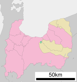
100:Location of Funahashi in Toyama Prefecture
25:
635:Geospatial Information Authority of Japan
606:
301:
275:
258:
237:
224:
173:
138:
104:
92:
64:
52:
614:Funahashi village official statistics
293:
283:
250:
242:
229:
212:
200:
183:
7:
955:
953:
941:List of mergers in Toyama Prefecture
637:(in Japanese). GSI. February 1, 2007
630:北陸地方で面積の大きい市町村上位10位及び面積の小さい市町村上位10位
234:3.47 km (1.34 sq mi)
965:This Toyama location article is a
356:of 3,304 in 1195 households and a
14:
1026:Toyama Prefecture geography stubs
118:
957:
782:
736:
681:
117:
110:
94:
79:
69:
54:
667:Funahashi population statistics
578:Toyama Chihō Railway Main Line
1:
1021:Villages in Toyama Prefecture
969:. You can help Knowledge by
330:
1042:
952:
373:Surrounding municipalities
15:
938:
780:
748:
453:—
406:Humid subtropical climate
324:
255:950/km (2,500/sq mi)
139:
105:
93:
65:
53:
44:
35:
629:
159:36.703528°N 137.307361°E
60:Funahashi Village Office
32:
16:Not to be confused with
23:Village in Chūbu, Japan
905:Higashitonami District
656:Funahashi climate data
524:
877:Shimoniikawa District
522:
427:Historical population
164:36.703528; 137.307361
930:Nishitonami District
920:Kaminiikawa District
855:Nakaniikawa District
690:at Wikimedia Commons
342:Nakaniikawa District
252: • Density
555:for nearby Toyama.
543:Agriculture (rice,
428:
270:Japan Standard Time
155: /
525:
378:Toyama Prefecture
358:population density
244: • Total
231: • Total
1016:Funahashi, Toyama
978:
977:
947:
946:
742:Toyama Prefecture
688:Funahashi, Toyama
686:Media related to
553:bedroom community
533:Toyama prefecture
512:
511:
346:Toyama Prefecture
316:
315:
1033:
999:
992:
985:
961:
954:
898:Former Districts
786:
759:
740:
730:
723:
716:
707:
702:
699:
698:
696:Official website
685:
669:
664:
658:
653:
647:
646:
644:
642:
625:
619:
618:
611:
442:
437:
429:
335:
333:
327:
326:
312:
311:
309:Official website
170:
169:
167:
166:
165:
160:
156:
153:
152:
151:
148:
121:
120:
114:
98:
83:
73:
58:
39:
38:
37:
26:
1041:
1040:
1036:
1035:
1034:
1032:
1031:
1030:
1006:
1005:
1004:
1003:
950:
948:
943:
934:
893:
843:
787:
778:
760:
753:
744:
734:
700:
694:
693:
678:
673:
672:
665:
661:
654:
650:
640:
638:
631:
627:
626:
622:
616:
612:
608:
603:
593:
583:Etchū-Funahashi
574:
569:
561:
541:
517:
421:
404:The town has a
402:
375:
367:
321:
307:
306:
163:
161:
157:
154:
149:
146:
144:
142:
141:
135:
134:
133:
132:
129:
128:
127:
126:
122:
101:
89:
88:
87:
86:
77:
76:
61:
49:
40:
33:
31:
24:
21:
12:
11:
5:
1039:
1037:
1029:
1028:
1023:
1018:
1008:
1007:
1002:
1001:
994:
987:
979:
976:
975:
962:
945:
944:
939:
936:
935:
933:
932:
927:
922:
917:
915:Imizu District
912:
907:
901:
899:
895:
894:
892:
891:
890:
889:
884:
874:
873:
872:
867:
862:
851:
849:
845:
844:
842:
841:
836:
831:
826:
821:
816:
811:
806:
801:
795:
793:
789:
788:
781:
779:
777:
776:
770:
768:
762:
761:
749:
746:
745:
735:
733:
732:
725:
718:
710:
704:
703:
691:
677:
676:External links
674:
671:
670:
659:
648:
620:
605:
604:
602:
599:
598:
597:
592:
589:
588:
587:
586:
585:
573:
570:
568:
567:Transportation
565:
560:
557:
540:
537:
529:Etchū Province
516:
513:
510:
509:
506:
503:
499:
498:
495:
492:
488:
487:
484:
481:
477:
476:
473:
470:
466:
465:
462:
459:
455:
454:
451:
448:
444:
443:
438:
433:
420:
417:
401:
398:
397:
396:
395:
394:
389:
384:
374:
371:
366:
363:
331:Funahashi-mura
314:
313:
304:
300:
299:
296:
292:
291:
289:Satsuki azalea
286:
282:
281:
278:
274:
273:
263:
257:
256:
253:
249:
248:
245:
241:
240:
236:
235:
232:
228:
227:
223:
222:
217:
211:
210:
205:
199:
198:
188:
182:
181:
178:
172:
171:
137:
136:
130:
124:
123:
116:
115:
109:
108:
107:
106:
103:
102:
99:
91:
90:
84:
78:
74:
68:
67:
66:
63:
62:
59:
51:
50:
45:
42:
41:
29:
22:
13:
10:
9:
6:
4:
3:
2:
1038:
1027:
1024:
1022:
1019:
1017:
1014:
1013:
1011:
1000:
995:
993:
988:
986:
981:
980:
974:
972:
968:
963:
960:
956:
951:
942:
937:
931:
928:
926:
923:
921:
918:
916:
913:
911:
910:Himi District
908:
906:
903:
902:
900:
896:
888:
885:
883:
880:
879:
878:
875:
871:
868:
866:
863:
861:
858:
857:
856:
853:
852:
850:
846:
840:
837:
835:
832:
830:
827:
825:
822:
820:
817:
815:
812:
810:
807:
805:
802:
800:
797:
796:
794:
790:
785:
775:
772:
771:
769:
767:
763:
757:
752:
747:
743:
739:
731:
726:
724:
719:
717:
712:
711:
708:
701:(in Japanese)
697:
692:
689:
684:
680:
679:
675:
668:
663:
660:
657:
652:
649:
636:
632:
624:
621:
617:(in Japanese)
615:
610:
607:
600:
595:
594:
590:
584:
581:
580:
579:
576:
575:
571:
566:
564:
558:
556:
554:
550:
546:
538:
536:
534:
530:
521:
514:
507:
504:
501:
500:
496:
493:
490:
489:
485:
482:
479:
478:
474:
471:
468:
467:
463:
460:
457:
456:
452:
449:
446:
445:
439:
434:
431:
430:
424:
418:
416:
414:
411:
407:
399:
393:
390:
388:
385:
383:
380:
379:
377:
376:
372:
370:
364:
362:
359:
355:
351:
347:
343:
339:
332:
320:
310:
305:
297:
290:
287:
279:
271:
267:
264:
262:
254:
246:
233:
221:
218:
216:
209:
206:
204:
196:
192:
189:
187:
179:
177:
168:
150:137°18′26.5″E
140:Coordinates:
113:
97:
82:
72:
57:
48:
43:
27:
19:
971:expanding it
964:
949:
925:Nei District
859:
662:
651:
641:September 3,
639:. Retrieved
634:
623:
609:
562:
549:acorn squash
542:
526:
422:
419:Demographics
412:
403:
368:
318:
317:
147:36°42′12.7″N
340:located in
220:Nakaniikawa
162: /
1010:Categories
814:Namerikawa
601:References
354:population
239:Population
203:Prefecture
860:Funahashi
848:Districts
766:Core city
559:Education
365:Geography
319:Funahashi
261:Time zone
125:Funahashi
30:Funahashi
18:Funabashi
870:Tateyama
865:Kamiichi
392:Tateyama
387:Kamiichi
285:• Flower
215:District
195:Hokuriku
829:Takaoka
756:capital
591:Highway
572:Railway
545:edamame
539:Economy
515:History
400:Climate
338:village
303:Website
295:Address
277:Symbols
176:Country
47:Village
887:Nyūzen
834:Tonami
809:Kurobe
792:Cities
774:Toyama
751:Toyama
497:+37.8%
486:+57.0%
410:Köppen
382:Toyama
280:
208:Toyama
186:Region
131:
882:Asahi
824:Oyabe
819:Nanto
804:Imizu
508:+5.6%
505:3,132
502:2020
494:2,967
491:2010
483:2,153
480:2000
475:+0.8%
472:1,371
469:1990
464:+0.2%
461:1,360
458:1980
450:1,357
447:1970
350:Japan
336:is a
266:UTC+9
247:3,304
191:Chūbu
180:Japan
967:stub
839:Uozu
799:Himi
643:2011
436:Pop.
432:Year
226:Area
85:Seal
75:Flag
413:Cfa
325:舟橋村
36:舟橋村
1012::
633:.
547:,
441:±%
348:,
344:,
328:,
998:e
991:t
984:v
973:.
758:)
754:(
729:e
722:t
715:v
645:.
408:(
334:)
322:(
272:)
268:(
197:)
193:(
20:.
Text is available under the Creative Commons Attribution-ShareAlike License. Additional terms may apply.