112:
338:
105:
326:
132:
29:
391:
353:(Gibralfaro Interpretation Center) in the former gunpowder arsenal of the Castle is a little museum that shows the castle’s history over the centuries since the Reconquest. The castle was used as a military base until 1925.
379:
Currently pending approval is a project intended to safeguard the mount and its surroundings from any urban intervention and promote it as a space for public recreation. Another project is planned to build a
486:
274:
expanded the fortifications within the
Phoenician lighthouse enclosure and erected a double wall to the Alcazaba. The name is said to be derived from
61:
535:
104:
390:
54:
530:
311:
397:
307:
415:
232:
540:
315:
169:
319:
342:
247:
364:
trees were planted on the hill. On its outskirts are the historical buildings of the seminary and the
365:
411:
349:
The most visible remains of the Castle today are the solid ramparts rising above the pines In the
228:
157:
502:
271:
124:
438:
419:
337:
263:
243:
215:
207:
325:
487:
Impulso al plan para proteger el Monte
Gibralfaro y potenciar su uso cultural - Málaga Hoy
515:
450:
150:
28:
524:
186:
381:
361:
262:
foundation of Málaga city, circa 770 BC. The location was fortified by Caliph
498:
76:
63:
373:
259:
174:
137:
239:
220:
194:
439:
Plan
Especial de Protección del Monte Gibralfaro - Ayuntamiento de Málaga
267:
275:
44:
238:
At the top of the hill stands the Castle of
Gibralfaro overlooking
336:
324:
287:
224:
357:
341:
Málaga from the ramparts of
Gibralfaro, looking towards the
290:, meaning "rock of the lighthouse". In Arabic it is called
322:, which ended when hunger forced the Arabs to surrender.
258:
Gibralfaro has been the site of fortifications since the
418:, formed of materials from the Maláguide complex of the
410:
Gibralfaro is part of the southern foothills of the
384:
linking the city center with the
Gibralfaro castle.
185:
180:
168:
163:
149:
92:
53:
43:
38:
21:
266:in 929 CE. At the beginning of the 14th century,
286:) the word for mountain, and Greek the word for
497:This article incorporates information from the
8:
306:). The castle is famous for its three-month
246:, and connected by a walled corridor to the
475:Conocer España por la ruta de los paradores
18:
431:
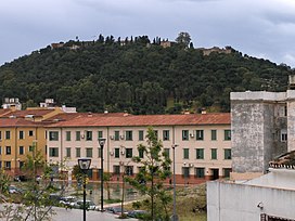
33:Mount Gibralfaro with the Castle on top
356:At the end of 2005, a thick forest of
351:Centro de Interpretación de Gibralfaro
333:to Castle of Gibralfaro from Alcazaba
227:. It is a 130 m high foothill of the
214:
7:
303:
295:
283:
372:(Dark Gate Gardens), as well as a
111:
14:
400:Panoramic Málaga from Gibralfaro
389:
130:
110:
103:
27:
516:Malaga City - Gibralfaro Castle
1:
451:"Gibralfaro Castle, Malaga"
216:[ˈmontexiβɾalˈfaɾo]
557:
477:, Ediciones Gaesa, page 90
414:, a mountain range of the
370:Jardines de Puerta Oscura
97:
26:
49:130 m (430 ft)
503:Spanish Knowledge (XXG)
329:Restored double walled
219:) is a hill located in
536:Landforms of Andalusia
346:
334:
211:
416:Cordillera Penibética
340:
328:
233:Cordillera Penibética
77:36.72333°N 4.41083°W
73: /
499:equivalent article
347:
335:
272:Kingdom of Granada
248:Alcazaba of Málaga
82:36.72333; -4.41083
39:Highest point
531:Penibaetic System
420:Baetic Cordillera
331:coracha terrestre
312:Catholic monarchs
264:Abd-al-Rahman III
244:Mediterranean Sea
200:
199:
16:Mountain in Spain
548:
489:
484:
478:
472:
466:
465:
463:
462:
447:
441:
436:
412:Montes de Málaga
393:
305:
297:
285:
229:Montes de Málaga
218:
212:Monte Gibralfaro
189:
158:Montes de Málaga
153:
140:
136:
134:
133:
114:
113:
107:
88:
87:
85:
84:
83:
78:
74:
71:
70:
69:
66:
31:
19:
556:
555:
551:
550:
549:
547:
546:
545:
521:
520:
512:
493:
492:
485:
481:
473:
469:
460:
458:
449:
448:
444:
437:
433:
428:
408:
403:
402:
401:
399:
394:
345:(visible below)
310:in 1487 by the
300:Jabal Al-Fārū (
256:
187:
151:
145:
144:
143:
142:
141:
131:
129:
128:
125:Málaga province
122:
121:
120:
119:
115:
81:
79:
75:
72:
67:
64:
62:
60:
59:
34:
17:
12:
11:
5:
554:
552:
544:
543:
541:Hills of Spain
538:
533:
523:
522:
519:
518:
511:
510:External links
508:
507:
506:
491:
490:
479:
467:
442:
430:
429:
427:
424:
407:
404:
396:
395:
388:
387:
386:
320:Queen Isabella
316:King Ferdinand
255:
252:
231:, part of the
198:
197:
191:
183:
182:
178:
177:
172:
166:
165:
161:
160:
155:
147:
146:
123:
117:
116:
109:
108:
102:
101:
100:
99:
98:
95:
94:
90:
89:
57:
51:
50:
47:
41:
40:
36:
35:
32:
24:
23:
15:
13:
10:
9:
6:
4:
3:
2:
553:
542:
539:
537:
534:
532:
529:
528:
526:
517:
514:
513:
509:
505:
504:
500:
495:
494:
488:
483:
480:
476:
471:
468:
456:
455:Andalucia.com
452:
446:
443:
440:
435:
432:
425:
423:
421:
417:
413:
405:
398:
392:
385:
383:
377:
375:
371:
367:
363:
359:
354:
352:
344:
339:
332:
327:
323:
321:
317:
313:
309:
301:
293:
289:
281:
277:
273:
269:
265:
261:
253:
251:
249:
245:
242:city and the
241:
236:
234:
230:
226:
223:in southeast
222:
217:
213:
209:
205:
196:
192:
190:
188:Easiest route
184:
179:
176:
173:
171:
170:Mountain type
167:
162:
159:
156:
154:
148:
139:
126:
106:
96:
91:
86:
58:
56:
52:
48:
46:
42:
37:
30:
25:
20:
496:
482:
474:
470:
459:. Retrieved
457:. 2011-11-25
454:
445:
434:
409:
378:
369:
355:
350:
348:
330:
299:
292:Jabal Fārū (
291:
279:
257:
237:
203:
201:
152:Parent range
80: /
55:Coordinates
525:Categories
461:2022-07-15
426:References
362:eucalyptus
304:جبل الفارو
260:Phoenician
204:Gibralfaro
118:Gibralfaro
68:04°24′39″W
65:36°43′24″N
22:Gibralfaro
382:cable car
175:Limestone
138:Andalusia
93:Geography
45:Elevation
366:Alcazaba
343:Alcazaba
302:Arabic:
296:جبل فارو
294:Arabic:
282:Arabic:
181:Climbing
501:on the
406:Geology
374:Parador
280:Jabal (
270:of the
268:Yusuf I
254:History
208:Spanish
164:Geology
368:, the
276:Arabic
240:Málaga
221:Málaga
202:Mount
195:Málaga
135:
358:pines
308:siege
298:) or
288:light
284:جَبَل
225:Spain
193:From
360:and
318:and
527::
453:.
422:.
376:.
314:,
278:,
250:.
235:.
210::
127:,
464:.
206:(
Text is available under the Creative Commons Attribution-ShareAlike License. Additional terms may apply.