532:
500:
163:
203:
170:
520:
196:
488:
41:
407:
which reaches an elevation of 2,469 metres (8,100 ft) above sea level with no glacier at the summit. In a 1917 official map, the mountain was indicated to be 2,481 metres (8,140 ft). So it was a matter of defining a glacier as a part of a mountain or not. The glacier has, however, shrunk in
439:
The route across the glacier that crowns the summit is completely without crevasses, but on a hot summer day it might be a wet hike across the melting snow which covers the ice. Visitors might even experience that the meltwater blows up across the summit, leaving hikers soaked. The view is
447:
There used to be a cabin at the summit, but because of the impossibility of mooring it sufficiently, it was knocked down by a storm and landed on the
Grjotbreen glacier, under the steep north wall of the summit.
499:
666:
531:
403:
Glittertind had earlier been a challenger for the title as the highest mountain in Norway, as measurements showed
Glittertind including the glacier was slightly higher than
618:
670:
436:
and can therefore only be reached by foot. The summit hike is a popular one, only surpassed in seasonal numbers by Galdhøpiggen, its western neighbor.
644:
548:
408:
recent years, and the dispute has been settled in Galdhøpiggen's favour. The summit of
Glittertind was reached for the first time in 1841 by
325:
104:
432:
lodge in the east, by a climb of about 1,000 metres (3,300 ft). The hike from
Glitterheim is the easier, but Glitterheim is inside the
519:
118:
724:
705:
440:
magnificent. East and southeast of
Glittertind there are hardly any high peaks, and hence most of the northern and eastern parts of
162:
751:
610:
487:
409:
588:
111:
433:
333:
365:
195:
76:
66:
88:
400:, measured as summer minimum. But in August 2022, the mountain was seen basically without the glacier.
756:
746:
444:
can be seen. All famous photos of
Glittertind are taken on the eastern flank slightly below the top.
396:
on top of its peak. As of 2008 it reached 2,465 metres (8,087 ft) above sea level including the
349:
640:
413:
98:
17:
720:
701:
643:[Restart of air route to Stockholm] (in Norwegian). TV 2 (Norway). 13 September 2022.
465:
369:
345:
257:
404:
381:
353:
81:
361:
357:
243:
740:
373:
262:
506:
425:
286:
276:
341:
336:. The mountain sits about 22 kilometres (14 mi) southeast of the village of
580:
429:
329:
313:
250:
392:
The mountain reaches an elevation of 2,452 metres (8,045 ft) without the
337:
133:
120:
441:
377:
317:
232:
344:. The mountain is surrounded by several other notable mountains including
469:
309:
428:
lodge in the west, by a climb of 1,300 metres (4,300 ft), and from
40:
510:
397:
393:
321:
293:
236:
56:
614:
340:
and about 38 kilometres (24 mi) southwest of the village of
641:"Det ikoniske fjellet er ugjenkjennelig: – Trist og vemodig"
696:
Dyer, Anthony; Baddeley, John; Robertson, Ian H. (2006).
324:. The 2,452-metre (8,045 ft) tall mountain is the
285:
275:
270:
256:
242:
228:
149:
110:
97:
87:
75:
65:
55:
50:
28:
472:'. The name of the river is derived from the verb
8:
460:and the last element is the finite form of
25:
493:Glittertind seen from east in July 1999.
565:
525:The summit seen from west in July 1999.
483:
456:The mountain is named after the river
549:List of mountains of Norway by height
7:
669:. Statens Kartverket. Archived from
575:
573:
571:
569:
476:which means 'glitter' or 'sparkle'.
202:
169:
717:Norway South: Rother Walking Guide
667:"Kristians amt nr 36: Jotunheimen"
591:from the original on 30 April 2022
14:
647:from the original on 8 March 2023
530:
518:
498:
486:
328:in Norway. It is located in the
201:
194:
168:
161:
39:
621:from the original on 1 May 2022
424:Glittertind is accessible from
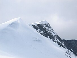
45:Glittertind, seen from the east
410:Harald Nicolai Storm Wergeland
1:
698:Walks and Scrambles in Norway
505:Glittertind (left) seen from
23:Mountain in Innlandet, Norway
719:. Bergverlag Rudolf Rother.
61:2,452 m (8,045 ft)
16:For the folk rock band, see
715:Pollmann, Bernhard (2000).
773:
71:975 m (3,199 ft)
15:
434:Jotunheimen National Park
334:Jotunheimen National Park
281:1841 (Wergeland, Sletten)
154:
38:
33:
537:Glittertind in year 1910
182:Location of the mountain
93:13 km (8.1 mi)
326:second highest mountain
752:Mountains of Innlandet
264:1618 III Glittertinden
185:Show map of Innlandet
611:"Glittertinden, Lom"
215:Glittertind (Norway)
134:61.65122°N 8.55759°E
700:. Rockbuy Limited.
673:on 22 December 2015
366:Austre Hestlægerhøe
130: /
509:(2,178 m) in
380:to the south; and
372:to the southeast;
360:to the northeast;
218:Show map of Norway
51:Highest point
18:Glittertind (band)
350:Trollsteinrundhøe
332:mountains within
299:
298:
139:61.65122; 8.55759
764:
730:
711:
683:
682:
680:
678:
663:
657:
656:
654:
652:
637:
631:
630:
628:
626:
613:(in Norwegian).
607:
601:
600:
598:
596:
577:
534:
522:
502:
490:
314:Lom Municipality
289:
265:
246:
219:
205:
204:
198:
186:
172:
171:
165:
145:
144:
142:
141:
140:
135:
131:
128:
127:
126:
123:
43:
26:
772:
771:
767:
766:
765:
763:
762:
761:
737:
736:
734:
727:
714:
708:
695:
692:
690:Further reading
687:
686:
676:
674:
665:
664:
660:
650:
648:
639:
638:
634:
624:
622:
609:
608:
604:
594:
592:
581:"Glittertinden"
579:
578:
567:
562:
557:
545:
538:
535:
526:
523:
514:
503:
494:
491:
482:
468:) which means '
454:
422:
390:
370:Nautgardstinden
346:Trollsteineggje
287:
263:
244:
224:
223:
222:
221:
220:
217:
216:
213:
212:
211:
210:
206:
189:
188:
187:
184:
183:
180:
179:
178:
177:
173:
138:
136:
132:
129:
124:
121:
119:
117:
116:
46:
24:
21:
12:
11:
5:
770:
768:
760:
759:
754:
749:
739:
738:
732:
731:
725:
712:
706:
691:
688:
685:
684:
658:
632:
602:
564:
563:
561:
558:
556:
553:
552:
551:
544:
541:
540:
539:
536:
529:
527:
524:
517:
515:
513:(Summer 2006).
504:
497:
495:
492:
485:
481:
478:
453:
450:
421:
418:
389:
386:
358:Grotbreahesten
356:to the north;
297:
296:
291:
283:
282:
279:
273:
272:
268:
267:
260:
254:
253:
248:
240:
239:
230:
226:
225:
214:
208:
207:
200:
199:
193:
192:
191:
190:
181:
175:
174:
167:
166:
160:
159:
158:
157:
156:
155:
152:
151:
147:
146:
114:
108:
107:
101:
95:
94:
91:
85:
84:
79:
73:
72:
69:
63:
62:
59:
53:
52:
48:
47:
44:
36:
35:
31:
30:
22:
13:
10:
9:
6:
4:
3:
2:
769:
758:
755:
753:
750:
748:
745:
744:
742:
735:
728:
726:9783763348077
722:
718:
713:
709:
707:9781904466253
703:
699:
694:
693:
689:
672:
668:
662:
659:
646:
642:
636:
633:
620:
616:
612:
606:
603:
590:
586:
585:PeakVisor.com
582:
576:
574:
572:
570:
566:
559:
554:
550:
547:
546:
542:
533:
528:
521:
516:
512:
508:
501:
496:
489:
484:
480:Media gallery
479:
477:
475:
471:
470:mountain peak
467:
463:
459:
451:
449:
445:
443:
437:
435:
431:
427:
419:
417:
415:
411:
406:
401:
399:
395:
387:
385:
384:to the west.
383:
379:
375:
374:Steinbukampen
371:
367:
364:to the east;
363:
359:
355:
351:
347:
343:
339:
335:
331:
327:
323:
319:
315:
311:
307:
306:Glittertinden
303:
295:
292:
290:
288:Easiest route
284:
280:
278:
274:
269:
266:
261:
259:
255:
252:
249:
247:
241:
238:
234:
231:
227:
197:
164:
153:
148:
143:
115:
113:
109:
106:
102:
100:
96:
92:
90:
86:
83:
80:
78:
74:
70:
68:
64:
60:
58:
54:
49:
42:
37:
34:Glittertinden
32:
27:
19:
733:
716:
697:
675:. Retrieved
671:the original
661:
649:. Retrieved
635:
623:. Retrieved
605:
593:. Retrieved
584:
507:Rondeslottet
473:
461:
457:
455:
446:
438:
426:Spiterstulen
423:
414:Hans Sletten
405:Galdhøpiggen
402:
391:
382:Galdhøpiggen
354:Svartholshøe
305:
301:
300:
277:First ascent
245:Parent range
82:Galdhøpiggen
757:Jotunheimen
747:Lom, Norway
430:Glitterheim
362:Veslekjølen
330:Jotunheimen
302:Glittertind
251:Jotunheimen
209:Glittertind
176:Glittertind
137: /
112:Coordinates
77:Parent peak
29:Glittertind
741:Categories
555:References
338:Fossbergom
122:61°39′04″N
67:Prominence
560:Footnotes
442:Innlandet
378:Veopallan
318:Innlandet
233:Innlandet
150:Geography
125:8°33′27″E
89:Isolation
57:Elevation
677:23 March
645:Archived
619:Archived
589:Archived
543:See also
320:county,
310:mountain
271:Climbing
258:Topo map
229:Location
651:8 March
511:Rondane
398:glacier
394:glacier
99:Listing
723:
704:
474:glitre
458:Glitra
420:Access
388:Height
352:, and
342:Vågåmo
322:Norway
294:Hiking
237:Norway
105:Norway
103:#2 in
625:1 May
615:yr.no
595:1 May
308:is a
721:ISBN
702:ISBN
679:2016
653:2023
627:2022
597:2022
462:tind
452:Name
412:and
376:and
368:and
316:in
312:in
304:or
743::
617:.
587:.
583:.
568:^
416:.
348:,
235:,
729:.
710:.
681:.
655:.
629:.
599:.
466:m
464:(
20:.
Text is available under the Creative Commons Attribution-ShareAlike License. Additional terms may apply.