296:
53:
122:
60:
299:
Sudan Air Force
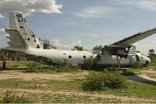
Antonov An-26-100. 7711 (cn 81–09) This an-26 crash-landed in 1997 at the airstrip of Gogrial. The plane got hit by SPLA-fire and had to make an emergency landing. Antonovs were used in the Sudanese Civil War as bombers and were feared by the population of Southern Sudan. 'VVll' is
405:
286:
As of July 2011, the exact population of
Gogrial is not known. However, it is estimated that the human population within a radius of 7 kilometres (4.3 mi), from the center of town, is approximately 44,600.
456:
384:
417:
503:
464:
358:
235:
137:
84:
52:
508:
421:
267:
295:
144:
227:
198:
161:
251:
243:
250:
region. This location lies approximately 700 kilometres (430 mi), by road, northwest of
322:
363:
315:
345:
231:
149:
441:
497:
348:, lies approximately 34 kilometres (21 mi), south of Gogrial, along Highway B38
341:
266:
flows north, then turns east, about 5 kilometres (3.1 mi) to the east of the
274:
was reported to have been born, with some reports saying he was actually born in
239:
215:
127:
300:
Arabic for '7711', which is written in
Western-style numbers on the port-side.
271:
479:
466:
304:
The points of interest in or near the town of
Gogrial include the following:
99:
86:
309:
263:
189:
326:
275:
337:
194:
156:
270:
of the town. This town is one of two places where former NBA player
330:
294:
262:
Gogrial, like most South
Sudanese towns, sits on a riverbank. The
247:
333:(B38) passes thorough Gogrial in a north to south direction
318:- A small civilian airport, with a single unpaved runway
188:
180:
175:
167:
155:
143:
133:
115:
21:
406:Map Showing Juba And Gogrial With Distance Marker
254:, the capital and largest city in that country.
385:"Gogrial Governor Establishes 13 New Counties"
8:
418:"Manute Bol Buried in Turalei, South Sudan"
312:- The river passes to the east of the town
18:
383:Manut, Ayul Santino (28 February 2016).
375:
187:
174:
166:
114:
79:
45:
37:
179:
154:
142:
132:
7:
16:Town in Bahr el Ghazal, South Sudan
504:Populated places in Warrap (state)
457:Location of Gogrial At Google Maps
14:
278:, where his remains were buried.
242:, close to the borders with the
120:
58:
51:
59:
1:
442:Estimated Population In 2011
525:
226:Gogrial is located in the
171:1,302 ft (397 m)
268:central business district
80:
46:
38:
31:
72:Location in South Sudan
301:
298:
480:8.53000°N 28.10000°E
100:8.53000°N 28.10000°E
509:Gogrial West County
476: /
321:The main road from
228:Gogrial West County
162:Gogrial West County
96: /
302:
291:Points of interest
181: • Total
485:8.53000; 28.10000
244:Republic of Sudan
205:
204:
105:8.53000; 28.10000
516:
491:
490:
488:
487:
486:
481:
477:
474:
473:
472:
469:
444:
439:
433:
432:
430:
429:
420:. Archived from
414:
408:
403:
397:
396:
394:
392:
380:
323:Wau, South Sudan
126:
124:
123:
111:
110:
108:
107:
106:
101:
97:
94:
93:
92:
89:
62:
61:
55:
19:
524:
523:
519:
518:
517:
515:
514:
513:
494:
493:
484:
482:
478:
475:
470:
467:
465:
463:
462:
453:
448:
447:
440:
436:
427:
425:
416:
415:
411:
404:
400:
390:
388:
382:
381:
377:
372:
364:Gogrial Airport
355:
316:Gogrial Airport
293:
284:
260:
224:
214:, is a town in
121:
119:
104:
102:
98:
95:
90:
87:
85:
83:
82:
76:
75:
74:
73:
70:
69:
68:
67:
63:
42:
39:Nickname:
34:
27:
24:
17:
12:
11:
5:
522:
520:
512:
511:
506:
496:
495:
460:
459:
452:
451:External links
449:
446:
445:
434:
409:
398:
374:
373:
371:
368:
367:
366:
361:
359:Bahr el Ghazal
354:
351:
350:
349:
334:
319:
313:
292:
289:
283:
280:
259:
256:
236:Bahr el Ghazal
223:
220:
203:
202:
192:
186:
185:
182:
178:
177:
173:
172:
169:
165:
164:
159:
153:
152:
147:
141:
140:
138:Bahr el Ghazal
135:
131:
130:
117:
113:
112:
78:
77:
71:
65:
64:
57:
56:
50:
49:
48:
47:
44:
43:
40:
36:
35:
32:
29:
28:
25:
22:
15:
13:
10:
9:
6:
4:
3:
2:
521:
510:
507:
505:
502:
501:
499:
492:
489:
458:
455:
454:
450:
443:
438:
435:
424:on 2012-03-24
423:
419:
413:
410:
407:
402:
399:
386:
379:
376:
369:
365:
362:
360:
357:
356:
352:
347:
343:
339:
335:
332:
328:
324:
320:
317:
314:
311:
307:
306:
305:
297:
290:
288:
281:
279:
277:
273:
269:
265:
257:
255:
253:
249:
245:
241:
237:
233:
229:
221:
219:
217:
213:
209:
200:
196:
193:
191:
183:
170:
163:
160:
158:
151:
148:
146:
139:
136:
129:
118:
109:
81:Coordinates:
54:
41:Pana Akuoldit
30:
20:
461:
437:
426:. Retrieved
422:the original
412:
401:
389:. Retrieved
378:
346:Warrap State
336:The town of
303:
285:
261:
232:Warrap State
225:
211:
207:
206:
150:Warrap State
483: /
240:South Sudan
216:South Sudan
128:South Sudan
103: /
498:Categories
471:28°06′00″E
428:2011-07-10
370:References
282:Population
272:Manute Bol
238:region of
176:Population
91:28°06′00″E
468:8°31′48″N
391:12 August
387:. Gurtong
310:Jur River
264:Jur River
234:, in the
190:Time zone
168:Elevation
88:8°31′48″N
353:See also
327:Babanusa
258:Overview
246:and the
222:Location
212:Qaqriyal
342:capital
276:Turalei
208:Gogrial
116:Country
66:Gogrial
26:Gakrial
23:Gogrial
340:- The
338:Kuajok
184:44,600
157:County
134:Region
125:
331:Sudan
248:Abyei
210:, or
195:UTC+2
145:State
393:2016
308:The
252:Juba
33:Town
344:of
325:to
230:of
199:CAT
500::
329:,
218:.
431:.
395:.
201:)
197:(
Text is available under the Creative Commons Attribution-ShareAlike License. Additional terms may apply.