442:
477:
522:
507:
462:
492:
71:
101:
441:
131:
506:
491:
427:) on the south side of the Monte Rosa massif. The Gorner Glacier proper is found on the north side. Now the prominent flow visible from Gornergrat is properly called the Grenzgletscher and can no longer be considered part of the Gorner Glacier. The Monte Rosa Glacier in the middle has also lost touch with the Gorner Glacier. This can be seen in a comparison of photographs over the years:
138:
108:
78:
322:
476:
54:
461:
521:
515:: The loss of thickness (about 200 m (660 ft)) of the lower Gorner Glacier since its major expansion in 1859 is recognizable on the south flank of the Gornergrat by the leftover and much higher lateral moraine (the light-coloured part above the grey flank); as seen from the Klein Matterhorn.
317:
to the south is nowadays the main contributor to the lower Gorner
Glacier. The Gorner Glacier's upper part is almost already disconnected from its lower part. The former tributaries Breithorngletscher, Triftjigletscher, and Unterer Theodulgletscher lost their connections to the Gorner Glacier during
359:
There are also notable surface features including crevasses and "table top" forms where large surface boulders have been left stranded above the glaciers surface. These tabular rocks are supported by ice that the boulder has sheltered from melting that has affected the more exposed surrounding ice.
500:: The connection between the Gorner Glacier and Grenzgletscher is still present and the moraine is still fed by the former; the old Monte Rosa Hut (2,795 m) is recognizable above the left over, north-eastern lateral moraine of the Grenzgletscher (in the middle, right).
282:. It is about 12.4 km (7.7 mi) long (2014) and 1 to 1.5 km (0.62 to 0.93 mi) wide. The entire glacial area of the glacier related to Gorner Glacier is 53 km (20 sq mi) (2007), which makes it the second largest glacial system in the
416:—in this case, dramatically so. As of 2014, Gorner Glacier had been retreating about 30 metres (98 ft) every year, but with a record loss of 290 metres (950 ft) in 2008. Since its last major expansion (in the modern era, after the
485:: Aerial photo from August 1994 with Gorner Glacier on the left and Grenzgletscher on the right, framing the Monte Rosa massif in the middle. The Monte Rosa Glacier no longer joins the Gorner Glacier.
352:
A notable feature of this glacier is the
Gornersee, an ice marginal lake at the confluence area of the Gorner Glacier and Grenzgletscher. This lake fills every year and drains in summer, usually as a
470:: Swiss Army patrol during World War I overlooking the confluence of the Gorner Glacier and Grenzgletscher; even the Monte Rosa Glacier in the middle still has contact to the Gorner Glacier.
302:(nowadays by far its main tributary, now disconnected from the Gorner Glacier proper), Zwillingsgletscher, Schwärzegletscher, Breithorngletscher, Triftjigletscher, and
189:
455:(built 1894–95) would have been found just few metres above the north-eastern border of the Grenzgletscher (in the middle; compare with the third picture).
530:: The upper Gorner Glacier is losing contact with the Grenzgletcher; the middle moraine in particular will no longer be fed by its originally upper part.
70:
298:) the Gorner Glacier (after which the whole system is named, although the upper part is now disconnected from the lower part), Monte Rosa Glacier,
725:
100:
423:
As of about 2015, the Gorner
Glacier had retreated to the point where it lost touch with its main tributary: the Grenzgletscher (English:
582:
412:
Like almost all other glaciers in the Alps, and most glaciers on the globe as well, the Gorner
Glacier is retreating as a result of
130:
544:
554:
58:
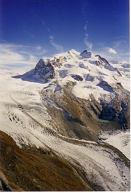
Gorner
Glacier (left), central Monte Rosa massif with Monte Rosa Glacier, and the confluence with the Grenzgletscher (2006)
1132:
182:
1127:
718:
353:
451:(photomechanical print): The upper Gorner Glacier (left) is still the main tributary of the lower part; the old
660:
711:
1043:
1036:
1021:
994:
982:
602:"Surface ice motion deviating toward the margins during speed-up events at Gornergletscher, Switzerland"
341:
1060:
1026:
876:
1055:
1016:
987:
697:
1106:
753:
1001:
417:
1065:
881:
972:
781:
401:
386:
791:
805:
901:
896:
796:
631:
337:
333:
267:
364:
1091:
621:
613:
549:
382:
303:
291:
275:
294:. Numerous smaller glaciers connect with the Gorner Glacier. Its (former) tributaries are (
1011:
691:
586:
287:
255:
871:
1101:
1050:
1031:
941:
861:
452:
413:
390:
379:
325:
299:
318:
the twentieth century; the
Unterer Theodulgletscher became disconnected in the 1980s.
1121:
977:
921:
648:
1096:
1070:
866:
856:
378:
itself. However, most of its water is captured by a water catchment station of the
936:
356:. This is one of only a few glacial lakes in the Alps exhibiting this behavior.
926:
841:
786:
279:
175:
53:
17:
1086:
946:
916:
911:
886:
810:
559:
397:
635:
204:
191:
951:
891:
851:
761:
734:
601:
321:
820:
420:) in 1859, it had lost more than 2,700 metres (8,900 ft) in distance.
31:
931:
836:
776:
617:
956:
906:
846:
765:
757:
748:
375:
369:
314:
271:
263:
626:
396:
The glacier as well as the surrounding mountains can be seen from the
661:"Gornergletscher length variation measurements between 1882 and 2017"
171:
585:. Swiss Glacier Monitoring, VAW/ETHZ & EKK/SCNAT. Archived from
295:
769:
320:
290:
system; however, in length it ranks third behind the
Aletsch and
815:
703:
400:(3,100 m or 10,200 ft), connected from Zermatt by the
283:
707:
348:) in the back (as seen near from the Old Monte Rosa Hut, 2006)
600:
Sugiyama, S.; Bauder, A.; Riesen, P.; Funk, M. (2010-07-27).
670:. Swiss Glacier Monitoring, VAW/ETHZ & EKK/SCNAT. 2014
1079:
965:
829:
741:
236:
228:
220:
181:
167:
159:
39:
313:) between the central Monte Rosa massif and the
30:"Gorner" redirects here. For the surname, see
719:
8:
385:power plant. This water then ends up in the
726:
712:
704:
36:
625:
571:
437:
363:The glacier is the source of the river
224:60 km (23 sq mi) (1973)
137:
107:
77:
7:
577:
575:
306:(the last three now disconnected).
25:
668:GLAMOS Glacier Monitoring Network
232:12.4 km (7.7 mi) (2014)
520:
505:
490:
475:
460:
440:
136:
129:
106:
99:
76:
69:
52:
27:Glacier on the Monte Rosa massif
606:Journal of Geophysical Research
583:"Gornergletscher, Zermatt (VS)"
545:List of glaciers in Switzerland
555:Retreat of glaciers since 1850
266:found on the west side of the
1:
309:The Grenzgletscher (English:
120:Show map of Canton of Valais
374:, which flows down through
354:glacial lake outburst flood
1149:
29:
424:
345:
329:
310:
244:
63:
51:
44:
389:, the main reservoir of
304:Unterer Theodulgletscher
90:Show map of Switzerland
349:
259:
324:
296:clockwise on this map
1133:Glaciers of the Alps
618:10.1029/2009JF001509
205:45.96972°N 7.80167°E
418:last glacial period
201: /
1128:Glaciers of Valais
1044:Monte Rosa Glacier
1037:Zwillingsgletscher
1022:Breithorngletscher
995:Tiefmatten Glacier
983:Schonbielgletscher
973:Matterhorn Glacier
877:Tête de Valpelline
694:glaciology.ethz.ch
402:Gornergrat Railway
350:
342:Zwillingsgletscher
1115:
1114:
1061:Hohlichtgletscher
1027:Schwärzegletscher
772:
292:Fiescher Glaciers
268:Monte Rosa massif
248:
247:
210:45.96972; 7.80167
16:(Redirected from
1140:
1092:Klein Matterhorn
1056:Mellichgletscher
1017:Triftjigletscher
988:Stockjigletscher
752:
728:
721:
714:
705:
679:
678:
676:
675:
665:
657:
651:
646:
640:
639:
629:
597:
591:
590:
579:
550:List of glaciers
524:
509:
494:
479:
464:
444:
426:
373:
347:
332:) in front with
331:
312:
276:canton of Valais
216:
215:
213:
212:
211:
206:
202:
199:
198:
197:
194:
151:
150:Show map of Alps
140:
139:
133:
121:
110:
109:
103:
91:
80:
79:
73:
56:
37:
21:
1148:
1147:
1143:
1142:
1141:
1139:
1138:
1137:
1118:
1117:
1116:
1111:
1075:
1012:Theodul Glacier
961:
825:
737:
732:
688:
683:
682:
673:
671:
663:
659:
658:
654:
647:
643:
599:
598:
594:
581:
580:
573:
568:
541:
536:
535:
534:
531:
525:
516:
510:
501:
495:
486:
480:
471:
465:
456:
445:
434:
433:
410:
408:Glacial retreat
367:
288:Aletsch Glacier
260:Gornergletscher
209:
207:
203:
200:
195:
192:
190:
188:
187:
155:
154:
153:
152:
149:
148:
147:
146:
145:
141:
124:
123:
122:
119:
118:
117:
116:
115:
111:
94:
93:
92:
89:
88:
87:
86:
85:
81:
59:
46:Gornergletscher
35:
28:
23:
22:
18:Gornergletscher
15:
12:
11:
5:
1146:
1144:
1136:
1135:
1130:
1120:
1119:
1113:
1112:
1110:
1109:
1104:
1102:Trockener Steg
1099:
1094:
1089:
1083:
1081:
1077:
1076:
1074:
1073:
1068:
1063:
1058:
1053:
1051:Findel Glacier
1048:
1047:
1046:
1041:
1040:
1039:
1032:Grenzgletscher
1029:
1024:
1019:
1014:
1007:Gorner Glacier
1004:
999:
998:
997:
992:
991:
990:
975:
969:
967:
963:
962:
960:
959:
954:
949:
944:
939:
934:
929:
924:
919:
914:
909:
904:
899:
894:
889:
884:
879:
874:
869:
864:
862:Ober Gabelhorn
859:
854:
849:
844:
839:
833:
831:
827:
826:
824:
823:
818:
813:
808:
803:
802:
801:
800:
799:
784:
779:
774:
745:
743:
739:
738:
733:
731:
730:
723:
716:
708:
702:
701:
698:Gorner Glacier
695:
692:Gorner Glacier
687:
686:External links
684:
681:
680:
652:
641:
612:(F3): F03010.
592:
589:on 2016-08-12.
570:
569:
567:
564:
563:
562:
557:
552:
547:
540:
537:
533:
532:
526:
519:
517:
511:
504:
502:
496:
489:
487:
481:
474:
472:
466:
459:
457:
453:Monte Rosa Hut
446:
439:
436:
435:
432:Gorner Glacier
431:
430:
429:
425:Border Glacier
414:global warming
409:
406:
391:Grande Dixence
380:Grande Dixence
330:Border Glacier
326:Grenzgletscher
311:Border Glacier
300:Grenzgletscher
262:) is a valley
252:Gorner Glacier
246:
245:
242:
241:
238:
234:
233:
230:
226:
225:
222:
218:
217:
185:
179:
178:
169:
165:
164:
163:Valley glacier
161:
157:
156:
144:Gorner Glacier
143:
142:
135:
134:
128:
127:
126:
125:
114:Gorner Glacier
113:
112:
105:
104:
98:
97:
96:
95:
84:Gorner Glacier
83:
82:
75:
74:
68:
67:
66:
65:
64:
61:
60:
57:
49:
48:
42:
41:
40:Gorner Glacier
26:
24:
14:
13:
10:
9:
6:
4:
3:
2:
1145:
1134:
1131:
1129:
1126:
1125:
1123:
1108:
1105:
1103:
1100:
1098:
1095:
1093:
1090:
1088:
1085:
1084:
1082:
1078:
1072:
1069:
1067:
1064:
1062:
1059:
1057:
1054:
1052:
1049:
1045:
1042:
1038:
1035:
1034:
1033:
1030:
1028:
1025:
1023:
1020:
1018:
1015:
1013:
1010:
1009:
1008:
1005:
1003:
1002:Furgg Glacier
1000:
996:
993:
989:
986:
985:
984:
981:
980:
979:
978:Zmutt Glacier
976:
974:
971:
970:
968:
964:
958:
955:
953:
950:
948:
945:
943:
940:
938:
935:
933:
930:
928:
925:
923:
922:Rimpfischhorn
920:
918:
915:
913:
910:
908:
905:
903:
900:
898:
895:
893:
890:
888:
885:
883:
882:Dent d'Hérens
880:
878:
875:
873:
870:
868:
865:
863:
860:
858:
855:
853:
850:
848:
845:
843:
840:
838:
835:
834:
832:
828:
822:
819:
817:
814:
812:
809:
807:
804:
798:
795:
794:
793:
790:
789:
788:
785:
783:
780:
778:
775:
771:
767:
763:
759:
755:
750:
747:
746:
744:
740:
736:
735:Matter Valley
729:
724:
722:
717:
715:
710:
709:
706:
699:
696:
693:
690:
689:
685:
669:
662:
656:
653:
650:
645:
642:
637:
633:
628:
623:
619:
615:
611:
607:
603:
596:
593:
588:
584:
578:
576:
572:
565:
561:
558:
556:
553:
551:
548:
546:
543:
542:
538:
529:
523:
518:
514:
508:
503:
499:
493:
488:
484:
478:
473:
469:
463:
458:
454:
450:
443:
438:
428:
421:
419:
415:
407:
405:
403:
399:
394:
392:
388:
384:
383:hydroelectric
381:
377:
371:
366:
361:
357:
355:
343:
339:
335:
327:
323:
319:
316:
307:
305:
301:
297:
293:
289:
285:
281:
277:
273:
269:
265:
261:
257:
253:
243:
239:
235:
231:
227:
223:
219:
214:
186:
184:
180:
177:
173:
170:
166:
162:
158:
132:
102:
72:
62:
55:
50:
47:
43:
38:
33:
19:
1097:Unterrothorn
1071:Ried Glacier
1066:Bisgletscher
1006:
872:Tête Blanche
867:Dent Blanche
857:Zinalrothorn
700:swisseduc.ch
672:. Retrieved
667:
655:
644:
609:
605:
595:
587:the original
527:
512:
497:
482:
467:
448:
422:
411:
395:
362:
358:
351:
346:Twin Glacier
308:
251:
249:
45:
927:Allalinhorn
842:Brunegghorn
787:St. Niklaus
742:Settlements
387:Lac des Dix
368: [
280:Switzerland
208: /
183:Coordinates
176:Switzerland
1122:Categories
1107:Schwarzsee
1087:Gornergrat
947:Lenzspitze
917:Strahlhorn
912:Monte Rosa
887:Matterhorn
792:Herbriggen
674:2022-08-31
627:2115/44748
566:References
560:Swiss Alps
398:Gornergrat
344:(English:
340:above the
328:(English:
286:after the
240:Retreating
193:45°58′11″N
952:Nadelhorn
937:Täschhorn
892:Breithorn
852:Weisshorn
830:Mountains
806:Gasenried
762:Riffelalp
636:0148-0227
468:1914–1918
449:1890–1900
270:close to
966:Glaciers
932:Alphubel
837:Barrhorn
797:Mattsand
539:See also
196:7°48′6″E
168:Location
1080:Tourism
957:Balfrin
907:Liskamm
847:Bishorn
811:Grächen
766:Zum See
758:Findeln
749:Zermatt
447:Around
376:Zermatt
365:Gornera
315:Liskamm
274:in the
272:Zermatt
264:glacier
902:Castor
897:Pollux
821:Törbel
634:
338:Pollux
334:Castor
256:German
237:Status
229:Length
172:Valais
32:Görner
782:Randa
777:Täsch
770:Zmutt
664:(PDF)
372:]
816:Embd
754:Ried
649:Foto
632:ISSN
528:2012
513:2007
498:2005
483:1994
336:and
284:Alps
250:The
221:Area
160:Type
942:Dom
622:hdl
614:doi
610:115
1124::
768:,
764:,
760:,
756:,
666:.
630:.
620:.
608:.
604:.
574:^
404:.
393:.
370:de
278:,
258::
174:,
773:)
751:(
727:e
720:t
713:v
677:.
638:.
624::
616::
254:(
34:.
20:)
Text is available under the Creative Commons Attribution-ShareAlike License. Additional terms may apply.