43:
68:
29:
75:
50:
355:. A forest mainly covers the left bank of the river. The speed of the flow is 2.2 m/s. The mouth of the river is located 103 km along the right bank of the Assa at an altitude of 1112 meters above sea level.
339:
The
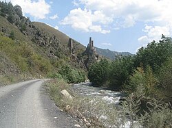
Guloykhi river originates in the eastern part of mountainous Ingushetia. It flows west along a mountain valley near several medieval tower settlements, most notably Gul, Läzhg, Qoyrakh, Abali,
67:
42:
383:
413:
446:[Register of registered in AGKGN geographical names of objects as of 12/17/2021: Republic of Ingushetia] (in Russian).
236:
495:
452:
171:
324:
385:
Reestr zaregistrirovannykh v AGKGN geograficheskikh nazvaniy ob'ektov na 17.12.2021: Republika
Ingushetia
444:"Реестр зарегистрированных в АГКГН географических названий объектов на 17.12.2021: Республика Ингушетия"
320:
120:
466:
459:
Ethnic composition of the population of the North
Caucasus in the 18th – early 20th centuries
303:
103:
344:
489:
417:
352:
207:
348:
328:
212:
140:
28:
251:
238:
186:
173:
340:
443:
130:
454:Этнический состав населения Северного Кавказа в XVIII — начале XX века
480:
462:
399:
314:
285:
277:
267:
228:
218:
206:
163:
155:
146:
136:
126:
116:
111:
91:
21:
451:Volkova, N. G. (1974). Gardanov, V. K. (ed.).
8:
95:
371:
364:
18:
481:Гулойхийское ущелье (Guloykhi valley)
7:
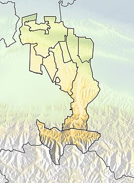
82:Show map of Republic of Ingushetia
14:
289:161 km (62 sq mi)
74:
73:
66:
49:
48:
41:
27:
230: • coordinates
165: • coordinates
57:Show map of Caucasus Mountains
1:
147:Physical characteristics
315:
273:1,112 m (3,648 ft)
269: • elevation
327:, a right tributary of the
220: • location
512:
398:Проект «Открытый Кавказ».
307:
96:
416:. skfo.ru. Archived from
202:
151:
35:
26:
224:103 km on the right bank
325:Republic of Ingushetia
347:, and flows into the
321:Dzheyrakhsky District
252:42.80556°N 44.93583°E
187:42.81333°N 45.18972°E
16:River in the Caucasus
496:Rivers of Ingushetia
461:] (in Russian).
319:) is a river in the
420:on 22 December 2019
248: /
183: /
257:42.80556; 44.93583
192:42.81333; 45.18972
121:Russian Federation
469:. pp. 1–276.
313:
293:
292:
503:
470:
447:
430:
429:
427:
425:
414:"Долина Гулойхи"
410:
404:
403:
395:
389:
381:
375:
369:
318:
312:romanized:
311:
309:
263:
262:
260:
259:
258:
253:
249:
246:
245:
244:
241:
198:
197:
195:
194:
193:
188:
184:
181:
180:
179:
176:
166:
107:
99:
98:
83:
77:
76:
70:
58:
52:
51:
45:
31:
19:
511:
510:
506:
505:
504:
502:
501:
500:
486:
485:
477:
450:
442:
439:
434:
433:
423:
421:
412:
411:
407:
397:
396:
392:
382:
378:
370:
366:
361:
337:
270:
256:
254:
250:
247:
242:
239:
237:
235:
234:
231:
221:
191:
189:
185:
182:
177:
174:
172:
170:
169:
164:
137:Federal subject
101:
87:
86:
85:
84:
81:
80:
79:
78:
61:
60:
59:
56:
55:
54:
53:
17:
12:
11:
5:
509:
507:
499:
498:
488:
487:
484:
483:
476:
475:External links
473:
472:
471:
448:
438:
435:
432:
431:
405:
390:
376:
374:, p. 143.
363:
362:
360:
357:
336:
333:
291:
290:
287:
283:
282:
279:
275:
274:
271:
268:
265:
264:
232:
229:
226:
225:
222:
219:
216:
215:
210:
204:
203:
200:
199:
167:
161:
160:
157:
153:
152:
149:
148:
144:
143:
138:
134:
133:
128:
124:
123:
118:
114:
113:
109:
108:
93:
89:
88:
72:
71:
65:
64:
63:
62:
47:
46:
40:
39:
38:
37:
36:
33:
32:
24:
23:
15:
13:
10:
9:
6:
4:
3:
2:
508:
497:
494:
493:
491:
482:
479:
478:
474:
468:
464:
460:
456:
455:
449:
445:
441:
440:
436:
419:
415:
409:
406:
402:(in Russian).
401:
394:
391:
387:
386:
380:
377:
373:
368:
365:
358:
356:
354:
351:near Puy and
350:
346:
342:
334:
332:
330:
326:
322:
317:
305:
301:
297:
288:
284:
280:
276:
272:
266:
261:
233:
227:
223:
217:
214:
211:
209:
205:
201:
196:
168:
162:
158:
154:
150:
145:
142:
139:
135:
132:
129:
125:
122:
119:
115:
110:
105:
94:
90:
69:
44:
34:
30:
25:
20:
458:
453:
437:Bibliography
422:. Retrieved
418:the original
408:
393:
388:, p. 5.
384:
379:
372:Volkova 1974
367:
353:Tkhaba-Yerdy
338:
299:
295:
294:
316:Ghuloy-Khiy
255: /
190: /
92:Native name
424:4 December
359:References
329:Assa River
308:ГӀулой-Хий
286:Basin size
243:44°56′09″E
240:42°48′20″N
213:Assa River
178:45°11′23″E
175:42°48′48″N
141:Ingushetia
341:Vovnushki
335:Geography
300:Guloy-khi
97:ГӀулой-хи
490:Category
296:Guloykhi
131:Caucasus
112:Location
22:Guloykhi
400:"Карта"
323:of the
117:Country
463:Moskva
304:Ingush
278:Length
159:
156:Source
127:Region
104:Ingush
100:
467:Nauka
457:[
298:, or
281:24 km
208:Mouth
426:2013
349:Assa
345:Koki
492::
465::
343:,
331:.
310:,
306::
428:.
302:(
106:)
102:(
Text is available under the Creative Commons Attribution-ShareAlike License. Additional terms may apply.