491:
869:
117:
503:
171:
90:
40:
62:
52:
479:
1142:
1164:
1134:
858:
1082:
97:
1337:
561:
Kemmel, Wijtschate, Nieuwkerke and
Westouter are the largest centres, with more than 1000 inhabitants each. The town hall and municipal administration are located in Kemmel, as are the police office and post office. The rest home, municipal sports hall and main library are located in Wijtschate. The
565:
Besides the village centres, a number of smaller residential areas are scattered on the territory. On top of the crest of the
Rodeberg and Zwarteberg small residential development, mixed with small shops, tourist businesses and restaurants are found. The city centre of
943:
947:
935:
346:
992:
927:
1232:
502:
939:
931:
195:
183:
490:
1044:
1225:
1788:
1218:
1762:
894:
area. The front-line ran through the area of
Wytschaete, which was captured and held several times by both sides during the course of the war.
1037:
133:
89:
1030:
310:
1524:
1345:
562:
municipal container park is found in
Nieuwkerke. The four other villages are smaller and accommodate less facilities.
1210:
731:
Because of its relative extensiveness, the municipality of
Heuvelland borders a large number of villages and towns:
1387:
219:
61:
1241:
899:
352:
30:
1641:
1470:
1265:
1183:
1125:
1112:
1099:
907:
868:
478:
453:
415:. On 1 January 2006 Heuvelland had a total population of 8,217. The total area is 94.24 km which gives a
51:
1683:
1581:
880:
286:
224:
1753:
116:
1703:
441:
779:
412:
427:
meaning "hill country", as the municipality is characterized by the different hills on its territory.
1245:
207:
1783:
1665:
898:
was an important German stronghold, and on 30 April and 17 June 1916, the area was the site of two
790:
457:
449:
395:. Heuvelland is a thinly populated rural municipality, located between the small urban centres of
1191:
1152:
416:
469:
39:
1104:
832:
188:
1483:
1187:
1148:
783:
960:
923:
508:
Heuvelland, "deelgemeenten" and neighbouring villages. The yellow areas are urban areas.
1442:
1253:
1117:
915:
895:
862:
825:
424:
339:
200:
1777:
1249:
967:
891:
360:
212:
1604:
1554:
1537:
1304:
1279:
971:
519:
1500:
1022:
887:
811:
758:
1649:
1376:
1326:
903:
875:
765:
744:
641:
609:
555:
543:
535:
461:
445:
388:
380:
148:
135:
1736:
1718:
1626:
1614:
1599:
1594:
1565:
1559:
1513:
1429:
1411:
1370:
1365:
1360:
1354:
1091:
1064:
839:
772:
737:
705:
689:
657:
625:
551:
547:
539:
523:
400:
392:
384:
372:
364:
857:
1724:
1659:
1654:
1532:
1495:
1460:
1455:
1418:
1405:
1321:
1309:
797:
751:
518:
The municipality
Heuvelland consists of eight small rural villages. The "
404:
298:
1631:
1589:
1549:
1478:
1449:
1400:
1395:
1315:
1299:
1273:
1257:
356:
176:
1336:
926:. There are a number of war cemeteries in the municipality, including
1730:
1672:
1609:
1571:
1543:
1506:
1489:
1424:
1286:
1179:
1175:
1121:
1108:
1095:
818:
593:
527:
465:
368:
570:
also expands a little on the territory of
Wijtschate in Heuvelland.
1710:
1697:
1620:
1435:
1293:
1197:
1069:
867:
856:
804:
673:
567:
531:
408:
396:
376:
1214:
1026:
496:
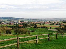
Landscape, with the village of Loker, as seen from the
Rodeberg
323:
1017:
550:
were independent municipalities before the merger in 1977.
993:"Wettelijke Bevolking per gemeente op 1 januari 2018"
861:
German concrete bunker at the
Bayernwald Trenches in
440:
The municipality is located in an area known as the
1682:
1640:
1580:
1523:
1469:
1386:
1344:
1264:
319:
309:
297:
285:
277:
269:
264:
256:
251:
243:
235:
230:
218:
206:
194:
182:
164:
21:
900:German gas attacks on British troops at Wulverghem
910:, and German units maintained a trench system (
886:The area experienced many major battles during
574:
1226:
1038:
684:
652:
620:
588:
363:. The municipality comprises the villages of
8:
721:Source: Ruimtelijk structuurplan Heuvelland
558:(then independent, now part of Poperinge).
1233:
1219:
1211:
1045:
1031:
1023:
18:
16:Municipality in Flemish Community, Belgium
444:. The highest hill in Heuvelland is the
1763:Municipalities with language facilities
984:
474:
318:
296:
284:
263:
250:
229:
163:
128:
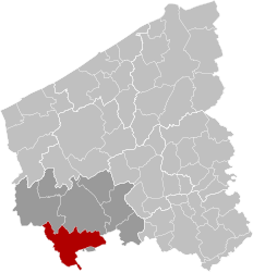
112:Location of Heuvelland in West Flanders
82:
45:
36:
554:wasn't independent, but was a part of
338:
308:
276:
268:
260:94.79 km (36.60 sq mi)
255:
244: • Governing party/ies
242:
234:
217:
205:
193:
181:
73:
7:
1060:
419:of 87 inhabitants per km. The name
96:
14:
974:was born and raised in Westouter.
1335:
1162:
1140:
1132:
1080:
959:The cartographer and astronomer
501:
489:
477:
169:
115:
95:
88:
60:
50:
38:
1789:Municipalities of West Flanders
948:Kemmel Number 1 French Cemetery
727:Neighbouring villages and towns
963:was born in Dranouter in 1552.
922:trenches can be visited as an
484:Kemmelberg, seen from the west
1:
1163:
1081:
1053:Places adjacent to Heuvelland
403:and the metropolitan area of
1141:
1133:
460:(125 m) and a lower hill in
700:
668:
636:
604:
572:
464:(82 m). On the border with
1805:
914:) within view of Ypres at
814:(city of Comines-Warneton)
800:(city of Comines-Warneton)
793:(city of Comines-Warneton)
704:
688:
672:
656:
640:
624:
608:
592:
1745:
1333:
1058:
906:was important during the
872:11 April 1918 during the
448:(154 m); followed by the
129:
83:
74:
46:
37:
28:
881:German spring offensive
883:
865:
281:83/km (210/sq mi)
77:Location of Heuvelland
1704:Langemark-Poelkapelle
871:
860:
292:8950-8954, 8956, 8958
247:Gemeentebelangen (GB)
239:Wieland De Meyer (GB)
340:[ˈɦøːvəlɑnt]
336:Dutch pronunciation:
278: • Density
109:Location in Belgium
747:(city of Poperinge)
740:(city of Poperinge)
145: /
884:
866:
585:Population (2001)
514:Municipality parts
442:West-Flemish Hills
417:population density
270: • Total
257: • Total
236: • Mayor
1771:
1770:
1208:
1207:
1203:
1202:
1105:Saint-Jans-Cappel
908:Battle of the Lys
890:, as part of the
833:Saint-Jans-Cappel
722:
717:
716:
329:
328:
324:www.heuvelland.be
189:Flemish Community
1796:
1339:
1235:
1228:
1221:
1212:
1188:Comines-Warneton
1166:
1165:
1149:Comines-Warneton
1144:
1143:
1136:
1135:
1084:
1083:
1061:
1047:
1040:
1033:
1024:
1018:Official website
1005:
1004:
1002:
1000:
989:
944:Klein Vierstraat
918:. Nowadays, the
784:Comines-Warneton
720:
573:
505:
493:
481:
350:
349:
348:
342:
337:
175:
173:
172:
160:
159:
157:
156:
155:
150:
149:50.767°N 2.817°E
146:
143:
142:
141:
138:
119:
99:
98:
92:
64:
54:
42:
19:
1804:
1803:
1799:
1798:
1797:
1795:
1794:
1793:
1774:
1773:
1772:
1767:
1741:
1678:
1636:
1576:
1519:
1507:Oostende/Ostend
1465:
1382:
1340:
1331:
1260:
1239:
1209:
1204:
1145:
1116:
1103:
1054:
1051:
1014:
1009:
1008:
998:
996:
991:
990:
986:
981:
961:Petrus Plancius
956:
924:open-air museum
879:as part of the
855:
850:
845:
807:(city of Mesen)
775:(city of Ypres)
768:(city of Ypres)
761:(city of Ypres)
754:(city of Ypres)
729:
516:
509:
506:
497:
494:
485:
482:
438:
433:
355:located in the
345:
344:
343:
335:
305:
293:
170:
168:
153:
151:
147:
144:
139:
136:
134:
132:
131:
125:
124:
123:
122:
121:
120:
113:
107:
106:
105:
104:
100:
79:
78:
70:
69:
68:
67:
58:
57:
33:
24:
17:
12:
11:
5:
1802:
1800:
1792:
1791:
1786:
1776:
1775:
1769:
1768:
1766:
1765:
1756:
1746:
1743:
1742:
1740:
1739:
1734:
1727:
1722:
1715:
1706:
1701:
1694:
1688:
1686:
1680:
1679:
1677:
1676:
1669:
1662:
1657:
1652:
1646:
1644:
1638:
1637:
1635:
1634:
1629:
1624:
1617:
1612:
1607:
1602:
1597:
1592:
1586:
1584:
1578:
1577:
1575:
1574:
1569:
1562:
1557:
1552:
1547:
1540:
1535:
1529:
1527:
1521:
1520:
1518:
1517:
1510:
1503:
1498:
1493:
1486:
1481:
1475:
1473:
1467:
1466:
1464:
1463:
1458:
1453:
1446:
1443:Spiere-Helkijn
1439:
1432:
1427:
1422:
1415:
1408:
1403:
1398:
1392:
1390:
1384:
1383:
1381:
1380:
1373:
1368:
1363:
1358:
1350:
1348:
1342:
1341:
1334:
1332:
1330:
1329:
1324:
1319:
1312:
1307:
1302:
1297:
1290:
1283:
1276:
1270:
1268:
1262:
1261:
1242:Municipalities
1240:
1238:
1237:
1230:
1223:
1215:
1206:
1205:
1201:
1200:
1195:
1173:
1170:
1169:
1167:
1160:
1157:
1156:
1146:
1131:
1129:
1088:
1087:
1085:
1078:
1075:
1074:
1072:
1067:
1059:
1056:
1055:
1052:
1050:
1049:
1042:
1035:
1027:
1021:
1020:
1013:
1012:External links
1010:
1007:
1006:
983:
982:
980:
977:
976:
975:
964:
955:
954:Notable people
952:
936:Spanbroekmolen
928:Godezonne Farm
916:Croonaert Wood
896:Spanbroekmolen
863:Croonaert Wood
854:
851:
849:
846:
844:
843:
836:
829:
822:
815:
808:
801:
794:
787:
776:
769:
762:
755:
748:
741:
733:
728:
725:
724:
723:
715:
714:
711:
708:
703:
699:
698:
695:
692:
687:
683:
682:
679:
676:
671:
667:
666:
663:
660:
655:
651:
650:
647:
644:
639:
635:
634:
631:
628:
623:
619:
618:
615:
612:
607:
603:
602:
599:
596:
591:
587:
586:
583:
580:
577:
515:
512:
511:
510:
507:
500:
498:
495:
488:
486:
483:
476:
437:
434:
432:
429:
327:
326:
321:
317:
316:
313:
307:
306:
303:
301:
295:
294:
291:
289:
283:
282:
279:
275:
274:
271:
267:
266:
262:
261:
258:
254:
253:
249:
248:
245:
241:
240:
237:
233:
232:
228:
227:
222:
220:Arrondissement
216:
215:
210:
204:
203:
201:Flemish Region
198:
192:
191:
186:
180:
179:
166:
162:
161:
127:
126:
114:
111:
110:
108:
102:
101:
94:
93:
87:
86:
85:
84:
81:
80:
76:
75:
72:
71:
65:
59:
55:
49:
48:
47:
44:
43:
35:
34:
29:
26:
25:
22:
15:
13:
10:
9:
6:
4:
3:
2:
1801:
1790:
1787:
1785:
1782:
1781:
1779:
1764:
1760:
1757:
1755:
1751:
1748:
1747:
1744:
1738:
1735:
1733:
1732:
1728:
1726:
1723:
1721:
1720:
1716:
1714:
1713:
1712:
1707:
1705:
1702:
1700:
1699:
1695:
1693:
1690:
1689:
1687:
1685:
1681:
1675:
1674:
1670:
1668:
1667:
1663:
1661:
1658:
1656:
1653:
1651:
1648:
1647:
1645:
1643:
1639:
1633:
1630:
1628:
1625:
1623:
1622:
1618:
1616:
1613:
1611:
1608:
1606:
1603:
1601:
1598:
1596:
1593:
1591:
1588:
1587:
1585:
1583:
1579:
1573:
1570:
1568:
1567:
1563:
1561:
1558:
1556:
1553:
1551:
1548:
1546:
1545:
1541:
1539:
1536:
1534:
1531:
1530:
1528:
1526:
1522:
1516:
1515:
1511:
1509:
1508:
1504:
1502:
1499:
1497:
1494:
1492:
1491:
1487:
1485:
1482:
1480:
1477:
1476:
1474:
1472:
1468:
1462:
1459:
1457:
1454:
1452:
1451:
1447:
1445:
1444:
1440:
1438:
1437:
1433:
1431:
1428:
1426:
1423:
1421:
1420:
1416:
1414:
1413:
1409:
1407:
1404:
1402:
1399:
1397:
1394:
1393:
1391:
1389:
1385:
1379:
1378:
1374:
1372:
1369:
1367:
1364:
1362:
1359:
1357:
1356:
1352:
1351:
1349:
1347:
1343:
1338:
1328:
1325:
1323:
1320:
1318:
1317:
1313:
1311:
1308:
1306:
1303:
1301:
1298:
1296:
1295:
1291:
1289:
1288:
1287:Bruges/Brugge
1284:
1282:
1281:
1277:
1275:
1272:
1271:
1269:
1267:
1263:
1259:
1255:
1251:
1250:West Flanders
1247:
1243:
1236:
1231:
1229:
1224:
1222:
1217:
1216:
1213:
1199:
1196:
1193:
1189:
1185:
1181:
1177:
1174:
1172:
1171:
1168:
1161:
1159:
1158:
1154:
1150:
1147:
1139:
1130:
1127:
1123:
1119:
1114:
1110:
1106:
1101:
1097:
1093:
1090:
1089:
1086:
1079:
1077:
1076:
1073:
1071:
1068:
1066:
1063:
1062:
1057:
1048:
1043:
1041:
1036:
1034:
1029:
1028:
1025:
1019:
1016:
1015:
1011:
994:
988:
985:
978:
973:
969:
968:Geike Arnaert
965:
962:
958:
957:
953:
951:
949:
945:
941:
937:
933:
929:
925:
921:
917:
913:
909:
905:
901:
897:
893:
892:Ypres Salient
889:
882:
878:
877:
874:Fight of the
870:
864:
859:
852:
847:
841:
837:
834:
830:
827:
823:
820:
816:
813:
809:
806:
802:
799:
795:
792:
788:
785:
781:
777:
774:
770:
767:
763:
760:
756:
753:
749:
746:
742:
739:
735:
734:
732:
726:
719:
718:
712:
709:
707:
701:
696:
693:
691:
685:
680:
677:
675:
669:
664:
661:
659:
653:
648:
645:
643:
637:
632:
629:
627:
621:
616:
613:
611:
605:
600:
597:
595:
589:
584:
581:
578:
575:
571:
569:
563:
559:
557:
553:
549:
545:
541:
537:
533:
529:
525:
521:
520:deelgemeentes
513:
504:
499:
492:
487:
480:
475:
473:
471:
467:
463:
459:
456:(129 m), the
455:
452:(136 m), the
451:
447:
443:
435:
430:
428:
426:
422:
418:
414:
410:
406:
402:
398:
394:
390:
386:
382:
378:
374:
370:
366:
362:
361:West Flanders
358:
354:
347:
341:
333:
325:
322:
314:
312:
302:
300:
290:
288:
280:
272:
259:
246:
238:
226:
223:
221:
214:
213:West Flanders
211:
209:
202:
199:
197:
190:
187:
185:
178:
167:
158:
154:50.767; 2.817
130:Coordinates:
118:
91:
63:
53:
41:
32:
27:
20:
1758:
1749:
1729:
1717:
1709:
1708:
1696:
1691:
1671:
1664:
1619:
1605:Oostrozebeke
1564:
1555:Lichtervelde
1542:
1538:Ingelmunster
1512:
1505:
1488:
1448:
1441:
1434:
1417:
1410:
1375:
1353:
1314:
1305:Knokke-Heist
1292:
1285:
1280:Blankenberge
1278:
1137:
997:. Retrieved
987:
972:Hooverphonic
919:
911:
885:
873:
791:Bas-Warneton
730:
564:
560:
517:
458:Scherpenberg
450:Vidaigneberg
439:
420:
359:province of
353:municipality
331:
330:
287:Postal codes
66:Coat of arms
31:Municipality
1698:Ieper/Ypres
1501:Middelkerke
888:World War I
853:World War I
812:Ploegsteert
759:Vlamertinge
152: /
1784:Heuvelland
1778:Categories
1761:indicates
1752:indicates
1692:Heuvelland
1666:Nieuwpoort
1650:Alveringem
1377:Lo-Reninge
1327:Zuienkerke
1138:Heuvelland
979:References
920:Bayernwald
912:Bayernwald
904:Kemmelberg
766:Voormezele
745:Reningelst
642:Nieuwkerke
610:Wijtschate
556:Reningelst
544:Wijtschate
536:Nieuwkerke
470:Zwarteberg
462:Wijtschate
446:Kemmelberg
421:heuvelland
411:along the
389:Wijtschate
381:Nieuwkerke
332:Heuvelland
311:Area codes
265:Population
231:Government
103:Heuvelland
23:Heuvelland
1737:Zonnebeke
1719:Poperinge
1627:Wielsbeke
1615:Ruiselede
1600:Meulebeke
1595:Dentergem
1566:Roeselare
1560:Moorslede
1525:Roeselare
1514:Oudenburg
1430:Lendelede
1412:Harelbeke
1371:Kortemark
1366:Koekelare
1361:Houthulst
1355:Diksmuide
1346:Diksmuide
1092:Boeschepe
1065:Poperinge
995:. Statbel
840:Boeschepe
782:(city of
773:Hollebeke
738:Poperinge
706:De Klijte
690:Westouter
658:Dranouter
626:Wulvergem
582:Area (km)
552:De Klijte
548:Wulvergem
540:Westouter
524:Dranouter
436:Landscape
431:Geography
401:Poperinge
393:Wulvergem
385:Westouter
373:De Klijte
365:Dranouter
184:Community
1725:Vleteren
1660:Koksijde
1655:De Panne
1533:Hooglede
1496:Ichtegem
1461:Zwevegem
1456:Wevelgem
1419:Kortrijk
1406:Deerlijk
1388:Kortrijk
1322:Zedelgem
1310:Oostkamp
1254:Flanders
1246:Province
1118:Bailleul
842:(France)
835:(France)
828:(France)
826:Bailleul
821:(France)
798:Warneton
752:Dikkebus
454:Rodeberg
405:Kortrijk
299:NIS code
208:Province
1632:Wingene
1590:Ardooie
1550:Ledegem
1484:De Haan
1479:Bredene
1450:Waregem
1401:Avelgem
1396:Anzegem
1316:Torhout
1300:Jabbeke
1274:Beernem
1258:Belgium
1244:in the
999:9 March
966:Singer
940:Suffolk
932:RE Farm
848:History
780:Houthem
468:is the
357:Belgian
351:) is a
320:Website
177:Belgium
165:Country
140:02°49′E
137:50°46′N
1759:Italic
1754:cities
1731:Wervik
1673:Veurne
1642:Veurne
1610:Pittem
1572:Staden
1544:Izegem
1490:Gistel
1471:Ostend
1425:Kuurne
1266:Bruges
1176:Nieppe
902:. The
876:Kemmel
819:Nieppe
697:1.422
649:1.513
617:2.109
601:1.170
594:Kemmel
528:Kemmel
466:France
369:Kemmel
196:Region
174:
1711:Mesen
1684:Ypres
1621:Tielt
1582:Tielt
1436:Menen
1294:Damme
1198:Mesen
1070:Ypres
805:Mesen
694:11,64
674:Loker
662:10,73
646:17,49
614:26,24
598:12,99
568:Mesen
532:Loker
522:" of
425:Dutch
409:Lille
397:Ypres
377:Loker
304:33039
273:7,862
225:Ypres
1750:Bold
1001:2019
946:and
713:576
710:4,93
702:VIII
681:572
678:6,80
665:703
633:264
630:3,50
579:Name
546:and
399:and
391:and
252:Area
56:Flag
1248:of
1192:WHT
1186:),
1153:WHT
970:of
838:o.
831:n.
824:m.
817:l.
810:k.
803:j.
796:i.
789:h.
778:g.
771:f.
764:e.
757:d.
750:c.
743:b.
736:a.
686:VII
622:III
423:is
413:E17
315:057
1780::
1256:,
1252:,
1184:59
1180:FR
1126:59
1122:FR
1113:59
1109:FR
1100:59
1096:FR
950:.
942:,
938:,
934:,
930:,
670:VI
638:IV
606:II
542:,
538:,
534:,
530:,
526:,
472:.
387:,
383:,
379:,
375:,
371:,
367:,
1234:e
1227:t
1220:v
1194:)
1190:(
1182:-
1178:(
1155:)
1151:(
1128:)
1124:-
1120:(
1115:)
1111:-
1107:(
1102:)
1098:-
1094:(
1046:e
1039:t
1032:v
1003:.
786:)
654:V
590:I
576:#
407:-
334:(
Text is available under the Creative Commons Attribution-ShareAlike License. Additional terms may apply.