156:
123:
116:
149:
605:
29:
275:
307:
There are two possible routes to reach the summit. Both routes start from roughly sea level and can be initiated at either
Berleneset or a parking lot at the cemetery at Hunskår. The easiest route follows a marked hiking trail that is roughly 7 km long and takes about four hours to reach the summit.
315:
climbing route named
Olavsrute, established in 2022. This route is graded F and can take up to 9 hours to complete. During the main season, a local guide can be hired to take one up the via ferrata. The route may also be climbed without a guide if one pays a maintenance fee.
282:
The horizontal distance from the summit to the sea is approximately 500 metres (1,600 ft). Approximately 1 kilometre (0.62 mi) to the west of the cliffside is the highest point on the island
319:
Due to safety concerns, the
Bremanger municipality has wanted to restrict access to the via ferrata so that it cannot be climbed without a hired guide. However, in 2024, the Vestland
406:
Larsen, Bjørn T.; Olaussen, Snorre; Sundvoll, Bjørn; Heereman, Michel (2007). "Volcanoes and faulting in an arid climate". In
Ramberg, Ivar; Bryhni, Inge; et al. (eds.).
646:
417:
639:
71:
486:
675:
573:
115:
632:
665:
433:
64:
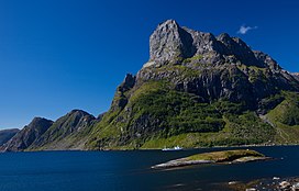
459:
336:
287:, called Svartevassegga which has an elevation of 889 metres (2,917 ft). The rock in Hornelen consists of
148:
327:
also applies to the
Hornelen via ferrata routes and that they can be climbed by anyone, even without a guide.
320:
382:
54:
670:
413:
362:
296:
324:
284:
244:
196:
248:
616:
341:
659:
201:
544:
28:
604:
215:
311:
The second and more demanding route to reach the summit follows a publicly funded
407:
312:
518:
268:
255:
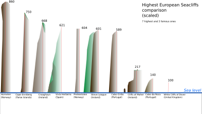
region of Norway. At 860 metres (2,820 ft), it is the third highest sea
86:
73:
288:
274:
252:
232:
612:
292:
264:
236:
185:
260:
240:
189:
44:
386:
273:
256:
263:(see illustration left), and has for a long time been used as a
487:"Skarpe reaksjonar på «sirkusløype» opp ikonisk norsk fjell"
611:
This article about a mountain, mountain range, or peak in
243:. The mountain sits on the eastern end of the island of
620:
460:"Topptur til Europas høgste sjøklippe Hornelen 860 moh"
572:
Nyhus, Håvard; Svalheim, Ole
Kristian (3 July 2024).
16:
Mountain in
Bremanger Municipality, Vestland, Norway
214:
209:
195:
181:
102:
63:
53:
43:
38:
21:
295:age, and it constitutes an important part of the
308:The hiking season lasts from June to November.
640:
8:
567:
565:
33:Hornelen, looking southwest from Rugsundøya.
512:
510:
508:
647:
633:
18:
574:"Staten opnar farleg klatresti for alle"
383:"Hornelen, Bremanger (Sogn og Fjordane)"
412:. Trondheim: Norsk Geologisk Forening.
409:The making of a land: Geology of Norway
353:
7:
601:
599:
453:
451:
434:"Bremanger Municipality in Norway"
14:
603:
155:
154:
147:
122:
121:
114:
27:
485:Nyhus, Håvard (19 July 2022).
278:Comparison of cliffs in Europe
1:
619:. You can help Knowledge by
337:List of mountains of Norway
692:
598:
49:860 m (2,820 ft)
543:Hornelen Via Ferrata AS.
517:Hornelen Via Ferrata AS.
303:Access and modern tourism
107:
26:
135:Location of the mountain
59:115 m (377 ft)
676:Vestland mountain stubs
279:
666:Mountains of Vestland
549:hornelenviaferrata.no
523:hornelenviaferrata.no
277:
138:Show map of Vestland
83: /
361:Bjørstad, Petter.
280:
171:Show map of Norway
87:61.8557°N 5.2468°E
39:Highest point
628:
627:
545:"Maintenance fee"
419:978-82-92394-42-7
297:geology of Norway
231:is a mountain in
226:
225:
168:Hornelen (Norway)
683:
649:
642:
635:
607:
600:
590:
589:
587:
585:
569:
560:
559:
557:
555:
540:
534:
533:
531:
529:
514:
503:
502:
500:
498:
482:
476:
475:
473:
471:
455:
446:
445:
443:
441:
430:
424:
423:
403:
397:
396:
394:
393:
385:(in Norwegian).
379:
373:
372:
370:
369:
358:
235:municipality in
218:
204:
172:
158:
157:
151:
139:
125:
124:
118:
98:
97:
95:
94:
93:
88:
84:
81:
80:
79:
76:
31:
19:
691:
690:
686:
685:
684:
682:
681:
680:
656:
655:
654:
653:
596:
594:
593:
583:
581:
571:
570:
563:
553:
551:
542:
541:
537:
527:
525:
516:
515:
506:
496:
494:
484:
483:
479:
469:
467:
458:Keipen Turlag.
457:
456:
449:
439:
437:
432:
431:
427:
420:
405:
404:
400:
391:
389:
381:
380:
376:
367:
365:
360:
359:
355:
350:
333:
325:freedom to roam
323:ruled that the
321:county governor
305:
285:Bremangerlandet
251:strait, in the
245:Bremangerlandet
222:From Berleneset
216:
202:
177:
176:
175:
174:
173:
170:
169:
166:
165:
164:
163:
159:
142:
141:
140:
137:
136:
133:
132:
131:
130:
126:
92:61.8557; 5.2468
91:
89:
85:
82:
77:
74:
72:
70:
69:
34:
17:
12:
11:
5:
689:
687:
679:
678:
673:
668:
658:
657:
652:
651:
644:
637:
629:
626:
625:
608:
592:
591:
580:(in Norwegian)
561:
535:
504:
493:(in Norwegian)
477:
466:(in Norwegian)
447:
436:. GoNorway.com
425:
418:
398:
374:
352:
351:
349:
346:
345:
344:
342:Hornelen Basin
339:
332:
329:
304:
301:
224:
223:
220:
212:
211:
207:
206:
199:
193:
192:
183:
179:
178:
167:
161:
160:
153:
152:
146:
145:
144:
143:
134:
128:
127:
120:
119:
113:
112:
111:
110:
109:
108:
105:
104:
100:
99:
67:
61:
60:
57:
51:
50:
47:
41:
40:
36:
35:
32:
24:
23:
15:
13:
10:
9:
6:
4:
3:
2:
688:
677:
674:
672:
669:
667:
664:
663:
661:
650:
645:
643:
638:
636:
631:
630:
624:
622:
618:
614:
609:
606:
602:
597:
579:
575:
568:
566:
562:
550:
546:
539:
536:
524:
520:
513:
511:
509:
505:
492:
488:
481:
478:
465:
461:
454:
452:
448:
435:
429:
426:
421:
415:
411:
410:
402:
399:
388:
384:
378:
375:
364:
357:
354:
347:
343:
340:
338:
335:
334:
330:
328:
326:
322:
317:
314:
309:
302:
300:
298:
294:
290:
286:
276:
272:
270:
266:
262:
258:
254:
250:
246:
242:
238:
234:
230:
221:
219:
217:Easiest route
213:
208:
205:
200:
198:
194:
191:
187:
184:
180:
150:
117:
106:
101:
96:
68:
66:
62:
58:
56:
52:
48:
46:
42:
37:
30:
25:
20:
621:expanding it
610:
595:
582:. Retrieved
577:
552:. Retrieved
548:
538:
526:. Retrieved
522:
495:. Retrieved
490:
480:
468:. Retrieved
463:
438:. Retrieved
428:
408:
401:
390:. Retrieved
377:
366:. Retrieved
356:
318:
310:
306:
281:
247:, along the
228:
227:
203:1118 I Måløy
519:"Olavsrute"
313:via ferrata
90: /
65:Coordinates
660:Categories
392:2019-10-13
368:2010-06-08
363:"Hornelen"
348:References
269:navigation
267:for naval
75:61°51′21″N
55:Prominence
671:Bremanger
289:sandstone
253:Nordfjord
249:Frøysjøen
233:Bremanger
103:Geography
78:5°14′48″E
45:Elevation
613:Vestland
440:3 August
331:See also
293:Devonian
265:landmark
239:county,
237:Vestland
229:Hornelen
210:Climbing
197:Topo map
186:Vestland
182:Location
162:Hornelen
129:Hornelen
22:Hornelen
584:10 July
554:14 July
528:10 July
497:10 July
470:10 July
578:nrk.no
491:nrk.no
416:
261:Europe
241:Norway
190:Norway
615:is a
464:ut.no
387:yr.no
257:cliff
617:stub
586:2024
556:2024
530:2024
499:2024
472:2024
442:2008
414:ISBN
291:of
259:in
662::
576:.
564:^
547:.
521:.
507:^
489:.
462:.
450:^
299:.
271:.
188:,
648:e
641:t
634:v
623:.
588:.
558:.
532:.
501:.
474:.
444:.
422:.
395:.
371:.
Text is available under the Creative Commons Attribution-ShareAlike License. Additional terms may apply.