473:
paradise as a deity. In a certain year, the then highest monk
Seosandaesa visited the temple, heard about this Buddhist rite, and guessed that there must be a secret behind it. Seosandesa allowed that year's chosen monk to pray wearing a silk robe anointed with poison, linked by a silk thread to Sinseodae Terrace. Seosandaesa then hid himself behind a rock to watch. At around 1 am, an imugi anaconda, which was sorry not to have turned into a dragon, slithered up from the valley below Sinseondae Terrace to the sound of roaring water. The imugi jumped upon the praying monk, bit him in the mouth, and disappeared into the water. Seosandaesa returned to the temple, and waited until dawn. Early in the morning, he, together with the villagers, went to Sinseondae Terrace to find that the imugi had died , having failed to swallow the whole body of the monk. Seosandaesa discovered Songnimsa Temple's secret of sacrificing a monk to an imugi every year. Thereafter, the valley was named Baemsagol, which means the valley where an imugi, which failed to become a dragon, died. The village at the entrance to Baemsagol Valley was named Banseon (meaning a "half deity") in memory of the dead monk because he was sacrificed without becoming a deity.
238:
231:
32:
617:
136:
647:
638:
629:
477:
656:
495:
544:
means "peak") is 1,284 m (4,213 ft) high and a popular, but strenuous, day-hike from the
Ssanggye Temple entry point (it is the closest major peak from this trailhead). From Ssanggyesa, a trail winds up 2.3 km to Bul-il Falls. From the left turn in the path just before the waterfall,
553:
suffix indicates a
Buddhist temple), the peak can be reached in four hours at a steady pace. There is a helipad near the summit for emergency services. It takes about three hours to get down; it is an extremely steep hike. Climbers are advised to bring plenty of water as it is only available from
463:
Every year more than 280,000 people visit
Jirisan. Summer and autumn are the most popular visiting seasons. The mountain is advertised as having ten scenic views. These are ‘Sunrise from Cheonwang-bong peak’, ‘Nogodan Sea of Clouds’, ‘Banyabong’s Nakjo’, ‘Full moon at Byukso-ryung’, ‘Piagol Autumn
472:
At the entrance to
Baemsagol Valley, some 1,300 years ago, there used to be Songnimsa Temple. This temple practiced an annual rite on the Chilwolbaekjung holiday (full moon day of July by the lunar calendar) wherein they selected the most pious monk and prayed earnestly for his safe passage to
455:
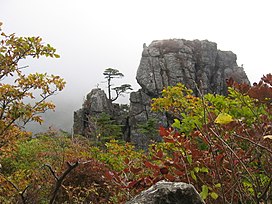
is the largest and best-known temple among these. It contains several national treasures, mostly stone artworks from about 600–900 CE. The mountain is also home to the
Cheonghak-dong (Azure Crane Village) alpine valley, which includes the
421:) and it is the largest in South Korea. The largest proportion of the national park is in the province of South Gyeongsang. The highest peak of the mountain, Cheonwangbong is also located in this province. Another well-known peak is
72:, is a useful starting point for translations, but translators must revise errors as necessary and confirm that the translation is accurate, rather than simply copy-pasting machine-translated text into the English Knowledge.
605:
Some plants were first found in Mt. Jiri and have 'Jirisan' or 'Jirisan'. However, some plants do not have 'geori' or 'geori' attached to them even though they were first found on Mt. Jiri.
905:
464:
Leaves’, ‘Royal Azalea
Blossoming’, ‘Chilseon Valley’, ‘Seomjincheongryu’, ‘Buril water fall’, ‘Yeonha-Sunkyung’. Jirisan National Park has several hiking routes.
900:
895:
602:
Jirisan is known to grow about 1,500 kinds of plants, many of which are endemic. This is the largest growth of plants in South Korea except for Mt. Halla.
590:
issued an "Anti-Guerrilla
Warfare Service Medal" for its troops who fought in the area and a movie about the fighting was later produced. An earlier film,
920:
75:
Do not translate text that appears unreliable or low-quality. If possible, verify the text with references provided in the foreign-language article.
910:
187:
83:
230:
827:
505:
798:
344:
672:
616:
516:
180:
578:
forces took the area in 1951, a considerable number of North
Koreans remained in the mountains, where they continued a
735:
756:
96:
Content in this edit is translated from the existing Korean
Knowledge article at ]; see its history for attribution.
677:
583:
925:
915:
859:
682:
91:
20:
930:
545:
the track continues 6.9 km to the peak (for a grand round-trip total of 18.4 km). Starting from
935:
158:
358:
940:
877:, Mason's pages on the religious character and sites of this remarkable set of peaks, slopes and gorges.
864:
655:
406:
112:
692:
173:
555:
802:
717:
697:
168:
594:, about a group of North Korean soldiers in the area, was released the year the fighting ended.
445:
87:
835:
890:
441:
437:
429:
418:
269:
646:
637:
628:
135:
945:
777:
476:
381:
575:
262:
44:
884:
579:
433:
806:
554:
streams beyond the temple grounds. This peak can also be climbed from the back of
460:(Three Sages Palace), which is a site celebrating one of Korea's foundation myths.
457:
414:
410:
281:
105:
587:
571:
395:
391:
250:
567:
546:
422:
202:
189:
874:
452:
399:
94:
to the source of your translation. A model attribution edit summary is
349:
334:
331:
328:
687:
591:
304:
288:
148:
869:
865:
Online mashup/interactive map of Jirisan hiking trails (in Korean)
475:
320:
870:
Korea in the Clouds: A Detailed Guide to Hiking Korea's Mountains
69:
582:, until they were finally beaten in 1955, two years after the
488:
25:
520:
778:"Republic of Korea: Anti-Guerrilla Warfare Service Medal"
394:. It is the second-tallest mountain in South Korea after
363:
512:
402:, and is the tallest mountain in mainland South Korea.
65:
451:There are seven major Buddhist temples on Jirisan.
357:
343:
319:
303:
298:
280:
275:
261:
218:
179:
167:
157:
147:
142:
128:
390:) is a mountain located in the southern region of
574:troops occupied the region in 1950. After the
90:accompanying your translation by providing an
56:Click for important translation instructions.
43:expand this article with text translated from
8:
860:Jirisan National Park-Official KNPS Homepage
385:
326:
310:
828:"[서울신문] [현진오의 꽃따라 산따라]지리산"
125:
709:
612:
906:Mountains of South Gyeongsang Province
799:"North Korean Partisan in South Korea"
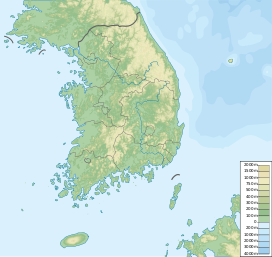
428:Jirisan is at the southern end of the
405:The 1915m-high mountain is located in
19:For other topics named similarly, see
16:Second tallest mountain in South Korea
7:
436:mountain ranges, the "spine" of the
901:Mountains of North Jeolla Province
896:Mountains of South Jeolla Province
409:. The park spans three provinces (
14:
654:
645:
636:
627:
615:
586:was signed by the belligerents.
493:
236:
229:
134:
30:
921:Sacred mountains of South Korea
718:"Highest Mountains South Korea"
444:mountain range and most of the
237:
911:One-thousanders of South Korea
386:
327:
311:
100:You may also add the template
1:
875:Jiri-san as a Sacred Mountain
673:National parks of South Korea
834:. 2013-05-01. Archived from
163:1,696 m (5,564 ft)
153:1,915 m (6,283 ft)
364:
350:
962:
678:List of mountains in Korea
584:Korean Armistice Agreement
64:Machine translation, like
18:
371:
294:
223:
133:
45:the corresponding article
683:Geography of South Korea
513:help improve the section
21:Jirisan (disambiguation)
519:or move the content to
111:For more guidance, see
481:
425:(Three Spirits Peak).
203:35.33694°N 127.73056°E
780:. Medals of the World
622:Jirisan National Park
479:
407:Jirisan National Park
113:Knowledge:Translation
102:{{Translated|ko|지리산}}
84:copyright attribution
693:Korea Forest Service
345:Revised Romanization
803:Korean Film Archive
698:Jirisan (TV series)
208:35.33694; 127.73056
199: /
517:encyclopedic style
515:by introducing an
504:is written like a
482:
440:incorporating the
143:Highest point
92:interlanguage link
538:
537:
375:
374:
359:McCune–Reischauer
124:
123:
57:
53:
953:
926:Sancheong County
916:Sobaek Mountains
847:
846:
844:
843:
824:
818:
817:
815:
814:
805:. Archived from
795:
789:
788:
786:
785:
774:
768:
767:
765:
764:
753:
747:
746:
744:
743:
732:
726:
725:
722:www.geonames.org
714:
661:Baemsagol valley
658:
649:
640:
631:
619:
533:
530:
524:
497:
496:
489:
448:mountain range.
438:Korean Peninsula
419:South Gyeongsang
389:
388:
367:
353:
338:
337:
314:
313:
284:
270:Sobaek Mountains
265:
240:
239:
233:
214:
213:
211:
210:
209:
204:
200:
197:
196:
195:
192:
138:
126:
103:
97:
70:Google Translate
55:
51:
34:
33:
26:
961:
960:
956:
955:
954:
952:
951:
950:
881:
880:
856:
851:
850:
841:
839:
826:
825:
821:
812:
810:
797:
796:
792:
783:
781:
776:
775:
771:
762:
760:
755:
754:
750:
741:
739:
734:
733:
729:
716:
715:
711:
706:
669:
662:
659:
650:
641:
632:
623:
620:
611:
600:
564:
534:
528:
525:
510:
498:
494:
487:
470:
339:
315:
282:
263:
257:
256:
255:
254:
253:
248:
247:
246:
245:
241:
207:
205:
201:
198:
193:
190:
188:
186:
185:
120:
119:
118:
101:
95:
58:
35:
31:
24:
17:
12:
11:
5:
959:
957:
949:
948:
943:
938:
933:
931:Hamyang County
928:
923:
918:
913:
908:
903:
898:
893:
883:
882:
879:
878:
872:
867:
862:
855:
854:External links
852:
849:
848:
819:
790:
769:
748:
727:
708:
707:
705:
702:
701:
700:
695:
690:
685:
680:
675:
668:
665:
664:
663:
660:
653:
651:
644:
642:
635:
633:
626:
624:
621:
614:
610:
607:
599:
596:
576:United Nations
563:
560:
556:Cheonghak-dong
536:
535:
501:
499:
492:
486:
483:
469:
466:
373:
372:
369:
368:
361:
355:
354:
347:
341:
340:
325:
323:
317:
316:
309:
307:
301:
300:
296:
295:
292:
291:
286:
278:
277:
273:
272:
267:
259:
258:
249:
243:
242:
235:
234:
228:
227:
226:
225:
224:
221:
220:
216:
215:
183:
177:
176:
171:
165:
164:
161:
155:
154:
151:
145:
144:
140:
139:
131:
130:
122:
121:
117:
116:
109:
98:
76:
73:
62:
59:
40:
39:
38:
36:
29:
15:
13:
10:
9:
6:
4:
3:
2:
958:
947:
944:
942:
939:
937:
936:Hadong County
934:
932:
929:
927:
924:
922:
919:
917:
914:
912:
909:
907:
904:
902:
899:
897:
894:
892:
889:
888:
886:
876:
873:
871:
868:
866:
863:
861:
858:
857:
853:
838:on 2013-05-01
837:
833:
829:
823:
820:
809:on 2012-05-28
808:
804:
800:
794:
791:
779:
773:
770:
758:
752:
749:
737:
731:
728:
723:
719:
713:
710:
703:
699:
696:
694:
691:
689:
686:
684:
681:
679:
676:
674:
671:
670:
666:
657:
652:
648:
643:
639:
634:
630:
625:
618:
613:
608:
606:
603:
597:
595:
593:
589:
585:
581:
580:guerrilla war
577:
573:
569:
561:
559:
557:
552:
548:
543:
540:Samshinbong (
532:
522:
518:
514:
508:
507:
502:This section
500:
491:
490:
484:
478:
474:
467:
465:
461:
459:
454:
449:
447:
443:
439:
435:
434:Baekdu-daegan
431:
426:
424:
420:
416:
412:
408:
403:
401:
397:
393:
383:
379:
370:
366:
362:
360:
356:
352:
348:
346:
342:
336:
333:
330:
324:
322:
318:
308:
306:
302:
297:
293:
290:
287:
285:
283:Easiest route
279:
274:
271:
268:
266:
260:
252:
232:
222:
217:
212:
184:
182:
178:
175:
172:
170:
166:
162:
160:
156:
152:
150:
146:
141:
137:
132:
127:
114:
110:
107:
99:
93:
89:
85:
81:
77:
74:
71:
67:
63:
61:
60:
54:
48:
46:
41:You can help
37:
28:
27:
22:
941:Gurye County
840:. Retrieved
836:the original
831:
822:
811:. Retrieved
807:the original
793:
782:. Retrieved
772:
761:. Retrieved
751:
740:. Retrieved
730:
721:
712:
604:
601:
572:North Korean
565:
550:
541:
539:
526:
506:travel guide
503:
480:Jirisan peak
471:
462:
458:Samseonggung
450:
427:
415:South Jeolla
404:
377:
376:
264:Parent range
88:edit summary
79:
52:(March 2022)
50:
42:
759:(in Korean)
738:(in Korean)
588:South Korea
566:During the
396:Jeju Island
392:South Korea
384::
299:Korean name
251:South Korea
206: /
194:127°43′50″E
181:Coordinates
885:Categories
842:2019-06-07
832:archive.fo
813:2013-04-07
784:2013-04-07
763:2018-06-14
742:2018-06-14
704:References
568:Korean War
547:Ssanggyesa
529:March 2022
521:Wikivoyage
423:Samsinbong
191:35°20′13″N
159:Prominence
598:Ecosystem
558:Village.
219:Geography
149:Elevation
106:talk page
47:in Korean
667:See also
453:Hwaeomsa
400:Hallasan
365:Chirisan
276:Climbing
82:provide
891:Jirisan
609:Gallery
562:History
511:Please
468:Legends
446:Taebaek
378:Jirisan
351:Jirisan
244:Jirisan
169:Listing
129:Jirisan
104:to the
86:in the
49:.
946:Namwon
688:Mayago
592:Piagol
442:Sobaek
430:Sobaek
382:Korean
305:Hangul
757:"뱀사골"
736:"지리산"
549:(the
485:Peaks
411:North
321:Hanja
174:Ultra
66:DeepL
542:bong
432:and
417:and
289:Hike
80:must
78:You
398:'s
387:지리산
312:지리산
68:or
887::
830:.
801:.
720:.
570:,
551:sa
413:,
845:.
816:.
787:.
766:.
745:.
724:.
531:)
527:(
523:.
509:.
380:(
335:山
332:異
329:智
115:.
108:.
23:.
Text is available under the Creative Commons Attribution-ShareAlike License. Additional terms may apply.