564:
638:
843:
47:
628:
The Kander correction was the first piece of major water course re-engineering in
Switzerland and lack of experience subsequently led to problems. The amount of water flowing into Lake Thun was increased by 60%, with a commensurate increase in outflow through the city of Thun. This caused flooding
697:
59:
727:
629:
and bank correction, which has been addressed over the years in different ways, including channeling of the Aare in 1716, a more major correction of the Aare in the 1870s, and a flood relief tunnel in the early 21st century.
450:
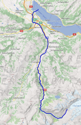
from the left, its major tributary, and turns to the north again and flows into the Lake of Thun after a break through a hill, which used to prevent it flowing into the lake until 1714. Here the river crosses the
621:, but with a tunnel instead of the unfinished cutting. Work was finished by the end of the year, but in 1714, the river started to enlarge the channel, causing the tunnel to collapse and creating today's
817:
555:. A road also follows the valley to Kandersteg and beyond into the Gastertal, but unlike the railway this is a dead-end, with no through road route across the mountains.
532:
or Kander canyon, is artificial, having been created as a result of the Kander
Correction (see below). At the end of the canyon, the river flows into
650:
758:
878:
670:
825:
213:
863:
868:
134:
675:
883:
540:
873:
452:
471:
massif. Initially the river in an easterly direction, until it turns sharply north just south of the village of
502:
661:
rafting party's inflatable boats capsized during an attempt to navigate the river; five soldiers were killed.
771:(in German). Biel: Herausgegeben vom Bundesamt für Wasser und Geologie BWG. pp. 60–69. Archived from
772:
544:
563:
618:
603:
847:
790:
434:. Continuing northwards, the Frutigtal makes a long bend to the west in order to get around the
760:
Die
Geschichte des Hochwasserschutzes in der Schweiz - Von den Anfängen bis ins 19. Jahrhundert
495:
479:
419:
351:
335:
506:
430:
at its south end, runs more or less parallel to the
Kandertal before they converge into the
355:
31:
802:
765:
The story of the flood protection in
Switzerland - From the beginnings to the 19th Century
514:
359:
614:
468:
376:
58:
857:
423:
617:. In the spring of 1713 work restarted under the direction of Bern's city architect
580:
552:
483:
399:
384:
637:
598:, there were early proposals to divert the river into the lake, thus avoiding the
487:
395:
379:
of 1,126 square kilometres (435 sq mi). Originally a tributary of the
372:
199:
180:
120:
116:
77:
658:
613:
The plans were approved in 1711, and work began but was delayed by the second
602:
and stopping the flooding. At the beginning of the 18th
Century, the engineer
510:
472:
464:
407:
228:
215:
149:
136:
821:
595:
533:
427:
388:
315:
303:
280:
195:
842:
491:
443:
415:
17:
46:
646:
584:
654:
518:
435:
636:
562:
522:
447:
439:
339:
311:
402:
at an altitude of 2,301 m (7,549 ft) flows through the
576:
548:
380:
307:
284:
87:
525:. The valley downstream of Frutigen is known as the Frutigtal.
539:
Between Mülenen and
Kandersteg, the river is followed by the
649:, the Kander is classified as unrunnable (level VI on the
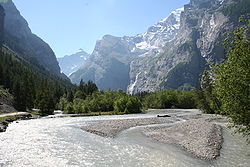
475:. This section of the valley is known as the Gastertal.
486:, joins the Kander. The river then runs north through
414:. After 14 kilometres (8.7 mi) it converges in
594:As the river flowed within a few hundred meters of
571:The Kander originally flowed through the low lying
345:
329:
321:
299:
294:
274:
266:
254:
244:
205:
189:
179:
165:
126:
110:
102:
93:
83:
73:
68:
39:
375:. It is 44 kilometres (27 mi) long and has a
547:, which passes under the Gastertal on its way to
816:Dale Bechtel and Scott Capper (June 12, 2008).
494:, where it is joined by another tributary, the
422:from the left, its second major tributary. The
606:created plans involving a cutting through the
406:westward. 3 kilometres (1.9 mi) south of
528:The last short section of today's river, the
8:
543:on its climb to the northern portal of the
641:The Kander at Klus, upstream of Kandersteg
610:ridge that separated the river and lake.
463:The source of the Kander is fed from the
752:
750:
748:
746:
722:
720:
718:
716:
692:
690:
686:
651:International Scale of River Difficulty
567:The artificially created Kanderschlucht
501:Below Frutigen the river flows through
798:
788:
383:, with a confluence downstream of the
36:
671:Oeschinensee and Kandertal landslides
482:, a tributary stream that drains the
7:
818:"River tragedy strikes Swiss army"
410:it turns to north into the larger
25:
841:
57:
45:
517:. Finally, near the village of
398:(glacier) in the middle of the
653:) due to the river's numerous
207: • coordinates
128: • coordinates
30:For the river in Germany, see
1:
676:List of rivers of Switzerland
94:Physical characteristics
879:Rivers of the canton of Bern
729:map.geo.admin.ch (Frutigtal)
699:map.geo.admin.ch (Gastertal)
394:The drainage water from the
246: • elevation
171:2,301 m (7,549 ft)
167: • elevation
51:The Kander in the Gasterntal
757:Vischer, Daniel L. (2003).
387:, since 1714 it flows into
276: • location
191: • location
112: • location
900:
732:(Map). Swiss Confederation
702:(Map). Swiss Confederation
250:558 m (1,831 ft)
29:
657:and barriers. In 2008, a
290:
262:
175:
98:
56:
44:
591:was repeatedly flooded.
503:Reichenbach im Kandertal
347: • right
864:Tributaries of the Aare
541:Lötschberg railway line
331: • left
258:44 km (27 mi)
828:on September 19, 2012.
642:
568:
446:it converges with the
391:upstream of the city.
869:Rivers of Switzerland
640:
575:area and entered the
566:
513:, where it meets the
505:, where it meets the
850:at Wikimedia Commons
615:Battle of Villmergen
229:46.71722°N 7.63944°E
150:46.46472°N 7.76500°E
63:Course of the Kander
27:River in Switzerland
884:Kander (Aare) basin
587:. As a result, the
478:In Kandersteg, the
295:Basin features
225: /
146: /
643:
625:or Kander canyon.
569:
846:Media related to
559:Kander Correction
545:Lötschberg tunnel
365:
364:
234:46.71722; 7.63944
155:46.46472; 7.76500
16:(Redirected from
891:
874:Bernese Oberland
845:
830:
829:
824:. Archived from
813:
807:
806:
800:
796:
794:
786:
784:
783:
777:
770:
754:
741:
740:
738:
737:
724:
711:
710:
708:
707:
694:
645:With respect to
348:
332:
277:
240:
239:
237:
236:
235:
230:
226:
223:
222:
221:
218:
168:
161:
160:
158:
157:
156:
151:
147:
144:
143:
142:
139:
129:
113:
61:
49:
37:
32:Kander (Germany)
21:
899:
898:
894:
893:
892:
890:
889:
888:
854:
853:
838:
833:
815:
814:
810:
797:
787:
781:
779:
775:
768:
756:
755:
744:
735:
733:
726:
725:
714:
705:
703:
696:
695:
688:
684:
667:
635:
561:
521:, it meets the
467:glacier in the
461:
346:
330:
275:
247:
233:
231:
227:
224:
219:
216:
214:
212:
211:
208:
192:
166:
154:
152:
148:
145:
140:
137:
135:
133:
132:
127:
111:
64:
52:
35:
28:
23:
22:
15:
12:
11:
5:
897:
895:
887:
886:
881:
876:
871:
866:
856:
855:
852:
851:
837:
836:External links
834:
832:
831:
808:
742:
712:
685:
683:
680:
679:
678:
673:
666:
663:
634:
631:
623:Kanderschlucht
608:Strättlighügel
560:
557:
530:Kanderschlucht
460:
457:
371:is a river in
363:
362:
349:
343:
342:
333:
327:
326:
323:
319:
318:
301:
297:
296:
292:
291:
288:
287:
278:
272:
271:
268:
264:
263:
260:
259:
256:
252:
251:
248:
245:
242:
241:
209:
206:
203:
202:
193:
190:
187:
186:
183:
177:
176:
173:
172:
169:
163:
162:
130:
124:
123:
114:
108:
107:
104:
100:
99:
96:
95:
91:
90:
85:
81:
80:
75:
71:
70:
66:
65:
62:
54:
53:
50:
42:
41:
26:
24:
14:
13:
10:
9:
6:
4:
3:
2:
896:
885:
882:
880:
877:
875:
872:
870:
867:
865:
862:
861:
859:
849:
844:
840:
839:
835:
827:
823:
819:
812:
809:
804:
792:
778:on 2008-12-06
774:
766:
762:
761:
753:
751:
749:
747:
743:
731:
730:
723:
721:
719:
717:
713:
701:
700:
693:
691:
687:
681:
677:
674:
672:
669:
668:
664:
662:
660:
656:
652:
648:
639:
632:
630:
626:
624:
620:
619:Samuel Jenner
616:
611:
609:
605:
604:Samuel Bodmer
601:
597:
592:
590:
586:
582:
578:
574:
565:
558:
556:
554:
550:
546:
542:
537:
535:
531:
526:
524:
520:
516:
512:
508:
504:
499:
497:
493:
489:
485:
481:
476:
474:
470:
466:
458:
456:
454:
449:
445:
441:
437:
433:
429:
425:
424:Engstligental
421:
417:
413:
409:
405:
401:
397:
392:
390:
386:
382:
378:
374:
370:
361:
357:
353:
350:
344:
341:
337:
334:
328:
324:
320:
317:
313:
309:
305:
302:
298:
293:
289:
286:
282:
279:
273:
269:
265:
261:
257:
253:
249:
243:
238:
210:
204:
201:
197:
194:
188:
184:
182:
178:
174:
170:
164:
159:
131:
125:
122:
118:
115:
109:
105:
101:
97:
92:
89:
86:
82:
79:
76:
72:
67:
60:
55:
48:
43:
38:
33:
19:
826:the original
811:
780:. Retrieved
773:the original
764:
759:
734:. Retrieved
728:
704:. Retrieved
698:
644:
627:
622:
612:
607:
599:
593:
588:
581:city of Thun
579:between the
573:Thun Allmend
572:
570:
553:Rhone Valley
538:
529:
527:
500:
484:Oeschinensee
477:
462:
431:
411:
403:
400:Bernese Alps
393:
385:city of Thun
368:
366:
799:|work=
488:Kandergrund
469:Blüemlisalp
453:A6 motorway
396:Kander Neve
373:Switzerland
322:Tributaries
300:Progression
232: /
200:Switzerland
153: /
121:Switzerland
117:Kander Neve
78:Switzerland
858:Categories
782:2013-10-23
736:2013-01-28
706:2013-01-28
682:References
659:Swiss Army
633:Navigation
490:as far as
473:Kandersteg
465:Kanderfirn
438:. Between
408:Kandersteg
404:Gasteretal
220:07°38′22″E
217:46°43′02″N
141:07°45′54″E
138:46°27′53″N
822:Swissinfo
801:ignored (
791:cite book
596:Lake Thun
534:Lake Thun
496:Engstlige
480:Öschibach
432:Frutigtal
428:Adelboden
420:Engstlige
418:with the
412:Kandertal
389:Lake Thun
377:watershed
352:Öschibach
336:Engstlige
316:North Sea
304:Lake Thun
281:Lake Thun
267:Discharge
196:Lake Thun
18:Kandertal
665:See also
551:and the
492:Frutigen
444:Reutigen
416:Frutigen
69:Location
647:rafting
600:Allmend
589:Allmend
585:Uttigen
511:Mülenen
74:Country
848:Kander
767:]
655:rapids
519:Wimmis
509:, and
507:Chiene
459:Course
436:Niesen
369:Kander
356:Chiene
325:
270:
255:Length
185:
106:
103:Source
40:Kander
776:(PDF)
769:(PDF)
763:[
523:Simme
448:Simme
440:Spiez
426:with
340:Simme
312:Rhine
181:Mouth
84:State
803:help
583:and
577:Aare
549:Brig
515:Suld
442:and
381:Aare
367:The
360:Suld
308:Aare
285:Aare
88:Bern
860::
820:.
795::
793:}}
789:{{
745:^
715:^
689:^
536:.
498:.
455:.
358:,
354:,
338:,
314:→
310:→
306:→
198:,
119:,
805:)
785:.
739:.
709:.
283:/
34:.
20:)
Text is available under the Creative Commons Attribution-ShareAlike License. Additional terms may apply.