52:
252:, joining the two islands. The border now crosses the southeastern part of the combined island, and is marked by two national cairns. The border on the island is around 420 metres (1,380 ft) long.
225:. The islet has an area of 71 hectares (180 acres). It is about 2 kilometres (1.2 mi) long and 200 to 500 metres (660 to 1,640 ft) wide.
401:
381:
376:
371:
366:
386:
396:
361:
391:
83:
237:
255:
Kataja's beaches are mostly boulders with some sand. The eastern peninsula is covered in deciduous trees such as
240:
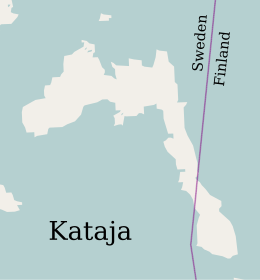
was established in 1809 between two islands, a larger
Swedish one called Kataja and a smaller Finnish one called
281:
31:
222:
245:
176:
155:
181:
160:
355:
214:
71:
98:
85:
249:
210:
276:
17:
332:
233:
229:
146:
51:
264:
218:
168:
304:
260:
256:
206:
267:, while the remainder is covered by coniferous trees.
248:
has caused the land in the region to rise relative to
30:
This article is about the islet. For other uses, see
192:
187:
175:
154:
138:
130:
122:
114:
77:
67:
62:
42:
315:
8:
37:
232:. The island is divided between Sweden and
50:
36:
27:Island shared between Sweden and Finland
297:
7:
118:0.71 km (0.27 sq mi)
25:
305:https://minkarta.lantmateriet.se/
228:The name "Kataja" is Finnish for
217:. It is the easternmost point of
402:Landforms of Lapland (Finland)
382:Uninhabited islands of Finland
1:
377:Uninhabited islands of Sweden
372:Finnish islands in the Baltic
367:Swedish islands in the Baltic
387:Islands of Norrbotten County
134:0.35 km (0.217 mi)
244:. In the years since then,
418:
29:
166:
143:
58:
49:
362:Extreme points of Sweden
282:List of divided islands
126:2 km (1.2 mi)
32:Kataja (disambiguation)
316:Kataja: bottenviken.se
221:and it is part of the
397:Finland–Sweden border
392:International islands
223:Haparanda archipelago
99:65.70105°N 24.16630°E
246:post-glacial rebound
95: /
39:
104:65.70105; 24.16630
339:. 7 December 2019
200:
199:
182:Norrbotten County
16:(Redirected from
409:
347:
345:
344:
319:
313:
307:
302:
110:
109:
107:
106:
105:
100:
96:
93:
92:
91:
88:
54:
40:
21:
417:
416:
412:
411:
410:
408:
407:
406:
352:
351:
350:
342:
340:
331:
322:
314:
310:
303:
299:
290:
273:
171:
150:
103:
101:
97:
94:
89:
86:
84:
82:
81:
45:
35:
28:
23:
22:
15:
12:
11:
5:
415:
413:
405:
404:
399:
394:
389:
384:
379:
374:
369:
364:
354:
353:
349:
348:
337:bottenviken.se
328:
321:
320:
308:
296:
289:
286:
285:
284:
279:
272:
269:
198:
197:
194:
190:
189:
185:
184:
179:
173:
172:
167:
164:
163:
158:
152:
151:
144:
141:
140:
139:Administration
136:
135:
132:
128:
127:
124:
120:
119:
116:
112:
111:
79:
75:
74:
69:
65:
64:
60:
59:
56:
55:
47:
46:
43:
26:
24:
14:
13:
10:
9:
6:
4:
3:
2:
414:
403:
400:
398:
395:
393:
390:
388:
385:
383:
380:
378:
375:
373:
370:
368:
365:
363:
360:
359:
357:
338:
334:
330:
329:
327:
326:
317:
312:
309:
306:
301:
298:
295:
294:
287:
283:
280:
278:
275:
274:
270:
268:
266:
262:
258:
253:
251:
247:
243:
239:
235:
231:
226:
224:
220:
216:
212:
208:
204:
195:
191:
186:
183:
180:
178:
174:
170:
165:
162:
159:
157:
153:
149:
148:
142:
137:
133:
129:
125:
121:
117:
113:
108:
80:
76:
73:
70:
66:
61:
57:
53:
48:
41:
33:
19:
341:. Retrieved
336:
324:
323:
311:
300:
292:
291:
254:
241:
227:
202:
201:
188:Demographics
145:
102: /
78:Coordinates
18:Katajavuori
356:Categories
343:2020-05-01
288:References
215:Norrbotten
193:Population
90:24°09′59″E
87:65°42′04″N
72:Baltic Sea
293:Citations
250:sea level
211:Haparanda
209:south of
63:Geography
333:"Kataja"
271:See also
68:Location
325:Sources
242:Inakari
234:Finland
230:juniper
161:Lapland
147:Finland
44:Inakari
277:Märket
265:willow
238:border
236:. The
219:Sweden
205:is an
203:Kataja
177:County
169:Sweden
156:Region
123:Length
38:Kataja
261:alder
257:rowan
207:islet
131:Width
263:and
115:Area
213:in
358::
335:.
259:,
346:.
318:.
196:0
34:.
20:)
Text is available under the Creative Commons Attribution-ShareAlike License. Additional terms may apply.