45:
61:
68:
260:
475:
The parish council was formed in 1895 with 7 elected members. This was replaced by Avoch
District Council in 1930, which was made up of the parishes of Avoch, Knockbain and Killearnan. The District Council had 7 members, 2 of whom were the County Councillors for the area and 5 elected to the District
463:
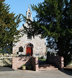
The parish church, west of
Redcastle, is also made of local red sandstone and dates from 1450. It was extensively altered in 1892, when the major part of the manse was built. The parish war memorial is sited at the crossroads in Newton about one mile (1.6 km) to the north-east from the church.
471:
in the north-east of the parish has a population of 307 (in 2011) and has a school, hall and other public facilities. Prior to 1891 Torre formed a detached part of the parish of
Killearnan, separated from the rest by a strip of Knockbain parish, 280 yards (260 metres) wide at the narrowest. In
445:, the population of the civil parish was 697. 4.9% had some knowledge of Gaelic. A hundred years before, in 1911, 46.7% were Gaelic speaking (and 52.7% in 1881). The area of the parish is 7,735 acres (12.1 sq mi; 31.3 km).
593:
Census of
Scotland 2011, Table KS101SC Usually Resident Population, publ. by National Records of Scotland. Web site www.scotlandscensus.gov.uk/ retrieved April 2021. See "Standard Outputs", Table KS101SC, Area type: Civil
431:
on the south and its church lies on the banks of that firth. The coastline is 5 miles (8.0 kilometres) and has no marked bay or indentation. The civil parish extends about 8 miles (13 kilometres) from east to west.
686:
Highland
Council - Scheme for the Establishment of Community Councils in Highland Updated Sept 2019 www.highland.gov.uk/download/downloads/id/4456/scheme_of_establishment_for_community_councils.pdf - retrieved Jan.
308:
326:
621:
Census of
Scotland 2011, Output Areas (Tore: Output Areas S00117900,S00117901,S00117902) – www.scotlandscensus.gov.uk/search-the-census#/location/OA?title=Output%20Area%202011 - retrieved April 2024.
460:
on rising ground near the firth. Kilcoy Castle (built early 17th century) was the seat of a barony belonging to the
Mackenzie family and has a commanding view of the upper part of the parish.
318:
300:
438:
The parish is mainly rural with no major villages or towns. The land gently rises to 518 feet (158 metres) at
Carnurnan, on the northern border with Urquhart and Logie Wester.
575:
Origines parochiales
Scotiae : the antiquities ecclesiastical and territorial of the parishes of Scotland, publ.by Bannatyne Club, Edinburgh 1851; Vol2, Part 2, p. 468
284:
137:
476:
Council from the parishes (Avoch had 2 members, and the other two parishes 1 member each). From 1976, this was superseded by
Killearnan Community Council
60:
246:
712:
612:
Census of Scotland 1931. Preliminary Report. Table 17 - Population and Acreage of Civil Parishes alphabetically arranged. Publ. H.M.S.O. 1931
566:
Third Statistical Account of Scotland, Vol 13 Ross and Cromarty, ed.A.S. Mather, publ. Scottish Academic Press, Edinburgh, 1987; pp. 191-197
359:
188:
272:
548:
Ordnance Gazetteer of Scotland, ed.Francis H. Groome, publ. Thomas C. Jack, Grange Publishing Works, Edinburgh, 1885; Vol 4, p. 365
344:
277:
234:
198:
603:
Twelfth Decennial Census of the Population of Scotland, 1911, publ. H.M.S.O. Edinburgh 1912; Vol 1, Part 31, Table I, p.1950
180:
130:
488:
44:
442:
396:
349:
289:
521:
416:
212:
162:
29:
408:
170:
656:
Eighth Annual Report of the Local Government Board for Scotland, 1902, publ.H.M.S.O., Glasgow, 1903; p. 530
674:
480:
covering the area of the civil parish, within Highland Region. The community council has 7 members.
110:
484:
477:
457:
404:
81:
696:
Highland - polling district map: map-highland.opendata.arcgis.com/ - retrieved April 2024
638:. School of GeoSciences, University of Edinburgh and The Royal Scottish Geographical Society
239:
631:
265:
504:
468:
706:
526:
472:
that year the strip was annexed to Killearnan, uniting the two parts of the parish.
453:
428:
146:
499:
400:
374:
361:
516:
449:
424:
222:
412:
204:
120:
487:
of Highland council and the remainder of Killearnan is in the ward of
420:
309:
Caithness, Sutherland and Easter Ross (UK Parliament constituency)
327:
Caithness, Sutherland and Ross (Scottish Parliament constituency)
227:
584:
Ordnance Survey 1 inch to one mile Sheet 22 Dornoch; publ.1958
456:
in the centre of the parish. Redcastle was built of local
16:
Civil parish in the Black Isle, Ross and Cromarty, Scotland
435:
The name Killearnan means "Iurnan's church" in Gaelic.
317:
299:
283:
271:
259:
245:
233:
221:
211:
197:
179:
161:
145:
129:
119:
108:
100:
92:
24:
448:The most significant buildings historically are
8:
562:
560:
558:
556:
554:
21:
636:The Editors of The Gazetteer for Scotland
544:
542:
538:
452:, near the shore of Beauly Firth and
298:
254:
220:
196:
128:
91:
41:
665:Local Government (Scotland) Act, 1929
316:
282:
270:
258:
244:
232:
210:
178:
160:
107:
7:
415:. It is bordered by the parish of
67:
14:
96:12.1 sq mi (31 km)
66:
59:
43:
1:
713:Parishes in Ross and Cromarty
427:in the east. It borders the
19:Human settlement in Scotland
131:OS grid reference
729:
677:11 March 1930; pp.296-298
522:Redcastle railway station
417:Urquhart and Logie Wester
335:
295:
255:
54:
42:
319:Scottish Parliament
49:Killearnan Parish Church
483:Tore is in the ward of
375:57.513055°N 4.377958°W
235:Postcode district
33:
675:The Edinburgh Gazette
489:Dingwall and Seaforth
467:The small village of
181:Lieutenancy area
115:54/sq mi (21/km)
380:57.513055; -4.377958
213:Sovereign state
80:Location within the
371: /
301:UK Parliament
247:Dialling code
478:community council
458:Old Red Sandstone
405:Ross and Cromarty
390:
389:
189:Ross and Cromarty
163:Council area
82:Ross and Cromarty
720:
697:
694:
688:
684:
678:
672:
666:
663:
657:
654:
648:
647:
645:
643:
628:
622:
619:
613:
610:
604:
601:
595:
591:
585:
582:
576:
573:
567:
564:
549:
546:
423:to the west and
386:
385:
383:
382:
381:
376:
372:
369:
368:
367:
364:
341:
207:
141:
140:
70:
69:
63:
47:
22:
728:
727:
723:
722:
721:
719:
718:
717:
703:
702:
701:
700:
695:
691:
685:
681:
673:
669:
664:
660:
655:
651:
641:
639:
630:
629:
625:
620:
616:
611:
607:
602:
598:
592:
588:
583:
579:
574:
570:
565:
552:
547:
540:
535:
513:
496:
379:
377:
373:
370:
365:
362:
360:
358:
357:
356:
339:
331:
313:
203:
193:
175:
157:
136:
135:
104:658 (2011)
88:
87:
86:
85:
78:
77:
76:
75:
71:
50:
38:
30:Scottish Gaelic
20:
17:
12:
11:
5:
726:
724:
716:
715:
705:
704:
699:
698:
689:
679:
667:
658:
649:
623:
614:
605:
596:
586:
577:
568:
550:
537:
536:
534:
531:
530:
529:
524:
519:
512:
509:
508:
507:
505:Tore, Scotland
502:
495:
492:
419:on the north,
388:
387:
355:
354:
352:
347:
342:
340:List of places
336:
333:
332:
330:
329:
323:
321:
315:
314:
312:
311:
305:
303:
297:
296:
293:
292:
287:
281:
280:
275:
269:
268:
263:
257:
256:
253:
252:
249:
243:
242:
237:
231:
230:
225:
219:
218:
217:United Kingdom
215:
209:
208:
201:
195:
194:
192:
191:
185:
183:
177:
176:
174:
173:
167:
165:
159:
158:
156:
155:
151:
149:
143:
142:
133:
127:
126:
123:
117:
116:
113:
106:
105:
102:
98:
97:
94:
90:
89:
79:
73:
72:
65:
64:
58:
57:
56:
55:
52:
51:
48:
40:
39:
37:
36:
26:
18:
15:
13:
10:
9:
6:
4:
3:
2:
725:
714:
711:
710:
708:
693:
690:
683:
680:
676:
671:
668:
662:
659:
653:
650:
637:
633:
627:
624:
618:
615:
609:
606:
600:
597:
590:
587:
581:
578:
572:
569:
563:
561:
559:
557:
555:
551:
545:
543:
539:
532:
528:
527:Kilcoy Castle
525:
523:
520:
518:
515:
514:
510:
506:
503:
501:
498:
497:
493:
491:
490:
486:
481:
479:
473:
470:
465:
461:
459:
455:
454:Kilcoy Castle
451:
446:
444:
439:
436:
433:
430:
426:
422:
418:
414:
410:
406:
403:peninsula of
402:
398:
394:
384:
353:
351:
348:
346:
343:
338:
337:
334:
328:
325:
324:
322:
320:
310:
307:
306:
304:
302:
294:
291:
288:
286:
279:
276:
274:
267:
264:
262:
250:
248:
241:
238:
236:
229:
226:
224:
216:
214:
206:
202:
200:
190:
187:
186:
184:
182:
172:
169:
168:
166:
164:
153:
152:
150:
148:
144:
139:
134:
132:
124:
122:
118:
114:
112:
103:
99:
95:
83:
62:
53:
46:
35:
31:
28:
27:
23:
692:
682:
670:
661:
652:
640:. Retrieved
635:
626:
617:
608:
599:
589:
580:
571:
482:
474:
466:
462:
447:
440:
437:
434:
429:Beauly Firth
397:civil parish
392:
391:
147:Civil parish
34:Cill Iùrnain
642:17 February
494:Settlements
443:2011 census
378: /
533:References
500:Artafallie
485:Black Isle
401:Black Isle
393:Killearnan
363:57°30′47″N
154:Killearnan
101:Population
74:Killearnan
25:Killearnan
517:Redcastle
511:Landmarks
450:Redcastle
425:Knockbain
366:4°22′41″W
285:Ambulance
223:Post town
707:Category
413:Scotland
411:area of
409:Highland
350:Scotland
290:Scottish
278:Scottish
266:Scotland
205:Scotland
171:Highland
138:NH768749
121:Language
441:At the
407:in the
399:in the
199:Country
125:English
111:Density
109:•
632:"Tore"
594:Parish
261:Police
421:Urray
395:is a
251:01862
687:2024
644:2018
469:Tore
273:Fire
228:Tain
93:Area
84:area
240:IV6
709::
634:.
553:^
541:^
345:UK
32::
646:.
Text is available under the Creative Commons Attribution-ShareAlike License. Additional terms may apply.