67:
92:
869:
332:
174:
786:Государственный Совет Республики Коми. Закон №11-РЗ от 5 марта 2005 г. «О территориальной организации местного самоуправления в Республике Коми», в ред. Закона №171-РЗ от 26 декабря 2014 г. «Об упразднении населённого пункта Верхняя Седка, расположенного на территории Прилузского района Республики Коми, и внесении в связи с этим изменений в некоторые Законы Республики Коми». Вступил в силу 1 апреля 2005 г.. Опубликован: "Республика", №44–45, 17 марта 2005 г.
766:Государственный Совет Республики Коми. Закон №13-РЗ от 6 марта 2006 г. «Об административно-территориальном устройстве Республики Коми», в ред. Закона №171-РЗ от 26 декабря 2014 г. «Об упразднении населённого пункта Верхняя Седка, расположенного на территории Прилузского района Республики Коми, и внесении в связи с этим изменений в некоторые Законы Республики Коми». Вступил в силу со дня официального опубликования. Опубликован: "Республика", №44, 16 марта 2006 г.
82:
947:
482:, кӧрт ("iron") and керӧс ("mountain"). Based on archaeological evidence and the names of locations (such as Körtyag, Lake Körtty, and the Körtvis River meaning "Iron Pine", "Iron Lake", and "Iron River" respectively), the village of Kortkeros was considered by archaeologists to be an ancient
66:
673:Численность населения России, субъектов Российской Федерации в составе федеральных округов, районов, городских поселений, сельских населённых пунктов – районных центров и сельских населённых пунктов с населением 3 тысячи и более человек
700:[All Union Population Census of 1989: Present Population of Union and Autonomous Republics, Autonomous Oblasts and Okrugs, Krais, Oblasts, Districts, Urban Settlements, and Villages Serving as District Administrative Centers].
697:Всесоюзная перепись населения 1989 г. Численность наличного населения союзных и автономных республик, автономных областей и округов, краёв, областей, районов, городских поселений и сёл-райцентров
676:[Population of Russia, Its Federal Districts, Federal Subjects, Districts, Urban Localities, Rural Localities—Administrative Centers, and Rural Localities with Population of Over 3,000]
799:
On
Abolishing the Inhabited Locality of Verkhnyaya Sedka Located on the Territory of Priluzsky District of the Komi Republic, and on Amending Various Laws of the Komi Republic Accordingly
779:
On
Abolishing the Inhabited Locality of Verkhnyaya Sedka Located on the Territory of Priluzsky District of the Komi Republic, and on Amending Various Laws of the Komi Republic Accordingly
858:
835:
499:
437:
91:
667:
609:
1187:
826:
514:
453:
280:
274:
868:
115:
790:
770:
641:
448:. It is located in the south of the republic. The area of the district is 19,760 square kilometers (7,630 sq mi). Its
81:
525:. Its eighteen administrative territories are incorporated as eighteen rural settlements within the municipal district. The
704:(in Russian). Институт демографии Национального исследовательского университета: Высшая школа экономики . 1989 – via
1059:
470:, the total population of the district was 19,658, with the population of Izhma accounting for 20.0% of that number.
1079:
1084:
916:
819:
1039:
155:
1159:
1074:
886:
599:
1154:
946:
1099:
1029:
931:
812:
724:[All Union Population Census of 1979. Ethnic composition of the population by regions of Russia]
518:
495:
307:
294:
256:
1129:
1016:
926:
906:
467:
449:
378:
368:
182:
544:
1134:
896:
398:
388:
936:
173:
44:
901:
804:
331:
1114:
911:
881:
736:(website of the Institute of Demographics of the State University—Higher School of Economics.
921:
413:
721:Всесоюзная перепись населения 1979 г. Национальный состав населения по регионам России
1124:
1054:
535:
serves as the administrative center of both the administrative and municipal district.
1181:
1064:
839:
503:
479:
441:
421:
160:
1094:
848:
671:
795:
On the
Territorial Organization of the Local Self-Government in the Komi Republic
1069:
719:
326:
695:
976:
483:
240:
229:
747:
130:
117:
1139:
1024:
981:
853:
532:
507:
463:
317:
262:
187:
17:
513:
and four settlement administrative territories, which comprise fifty-three
1164:
1119:
1104:
1089:
797:, as amended by the Law #171-RZ of December 26, 2014
777:, as amended by the Law #171-RZ of December 26, 2014
1144:
996:
971:
527:
458:
1149:
1109:
1049:
1044:
1034:
1001:
991:
445:
322:
1006:
986:
966:
433:
340:
961:
775:
808:
793:. Law #11-RZ of March 5, 2005
773:. Law #13-RZ of March 6, 2006
604:[2010 All-Russian Population Census, vol. 1].
354:
781:. Effective as of the official publication date.).
601:Всероссийская перепись населения 2010 года. Том 1
106:
1015:
954:
874:
397:
387:
377:
367:
350:
339:
316:
305:
291:
286:
272:
254:
249:
238:
227:
219:
211:
206:
198:
193:
181:
166:
154:
146:
56:
51:
32:
598:Russian Federal State Statistics Service (2011).
682:Всероссийская перепись населения 2002 года
606:Всероссийская перепись населения 2010 года
646:Официальный интернет-портал правовой информации
820:
784:
764:
730:Всесоюзная перепись населения 1979 года
702:Всесоюзная перепись населения 1989 года
8:
801:. Effective as of April 1, 2005.).
593:
591:
589:
362:
827:
813:
805:
330:
172:
29:
312:0 urban settlements, 18 rural settlements
268:, 4 settlement administrative territories
627:
625:
623:
621:
619:
506:. The district is divided into fourteen
579:
577:
575:
573:
571:
569:
567:
565:
561:
349:
315:
285:
248:
205:
192:
180:
165:
145:
110:
103:
75:
63:
55:
50:
498:, Kortkerossky District is one of the
361:
202:19,760 km (7,630 sq mi)
496:framework of administrative divisions
478:Kortkeros' name was derived from two
338:
304:
290:
271:
253:
237:
226:
218:
210:
197:
153:
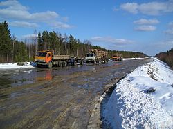
71:Logging trucks, Kortkerossky District
7:
490:Administrative and municipal status
363:Population of Kortkerossky District
791:State Council of the Komi Republic
771:State Council of the Komi Republic
521:, the district is incorporated as
25:
432:) is an administrative district (
27:District in Komi Republic, Russia
945:
867:
668:Federal State Statistics Service
610:Federal State Statistics Service
90:
80:
65:
732:(in Russian). 1979 – via
523:Kortkerossky Municipal District
301:Kortkerossky Municipal District
1188:Districts of the Komi Republic
1:
52:Other transcription(s)
1204:
648:(in Russian). June 3, 2011
511:administrative territories
266:administrative territories
943:
865:
846:
785:
765:
425:
417:
111:
104:
76:
64:
42:
875:Administrative districts
836:Administrative divisions
729:
720:
701:
696:
681:
672:
605:
600:
295:Municipally incorporated
257:Administrative divisions
250:Administrative structure
223:0.99/km (2.6/sq mi)
642:"Об исчислении времени"
355:http://www.kortkeros.ru
1017:Urban-type settlements
1130:Verkhnyaya Maksakovka
450:administrative center
410:Kortkerossky District
183:Administrative center
34:Kortkerossky District
418:Корткеросский райо́н
275:Inhabited localities
220: • Density
364:
308:Municipal divisions
287:Municipal structure
127: /
37:Корткеросский район
917:Troitsko-Pechorsky
545:Kört-Aika Monument
519:municipal division
212: • Total
199: • Total
1173:
1172:
1115:Troitsko-Pechorsk
407:
406:
360:
359:
131:61.800°N 51.583°E
57: • Komi
16:(Redirected from
1195:
955:Cities and towns
949:
871:
859:Rural localities
829:
822:
815:
806:
788:
787:
768:
767:
752:
751:
748:"Село Корткерос"
744:
738:
737:
734:Demoscope Weekly
727:
716:
710:
709:
706:Demoscope Weekly
692:
686:
685:
679:
670:(May 21, 2004).
664:
658:
657:
655:
653:
638:
632:
629:
614:
613:
595:
584:
581:
515:rural localities
427:
419:
365:
334:
298:
281:rural localities
177:
176:
142:
141:
139:
138:
137:
132:
128:
125:
124:
123:
120:
94:
84:
69:
30:
21:
1203:
1202:
1198:
1197:
1196:
1194:
1193:
1192:
1178:
1177:
1174:
1169:
1125:Verkhnyaya Inta
1011:
950:
941:
887:Knyazhpogostsky
872:
861:
842:
833:
761:
756:
755:
746:
745:
741:
731:
725:
722:
718:
717:
713:
703:
698:
694:
693:
689:
683:
677:
674:
666:
665:
661:
651:
649:
640:
639:
635:
630:
617:
607:
602:
597:
596:
587:
582:
563:
558:
553:
541:
492:
476:
430:Körtkerös rajon
426:Кӧрткерӧс район
293:
171:
156:Federal subject
135:
133:
129:
126:
121:
118:
116:
114:
113:
107:
100:
99:
98:
97:
88:
87:
72:
60:Кӧрткерӧс район
47:
38:
35:
28:
23:
22:
15:
12:
11:
5:
1201:
1199:
1191:
1190:
1180:
1179:
1171:
1170:
1168:
1167:
1162:
1157:
1152:
1147:
1142:
1137:
1132:
1127:
1122:
1117:
1112:
1107:
1102:
1097:
1092:
1087:
1082:
1077:
1072:
1067:
1062:
1060:Mezhdurechensk
1057:
1055:Krasnozatonsky
1052:
1047:
1042:
1037:
1032:
1027:
1021:
1019:
1013:
1012:
1010:
1009:
1004:
999:
994:
989:
984:
979:
974:
969:
964:
958:
956:
952:
951:
944:
942:
940:
939:
934:
929:
924:
919:
914:
909:
904:
899:
894:
889:
884:
878:
876:
873:
866:
863:
862:
847:
844:
843:
834:
832:
831:
824:
817:
809:
803:
802:
782:
760:
757:
754:
753:
739:
711:
687:
659:
633:
615:
608:(in Russian).
585:
560:
559:
557:
554:
552:
549:
548:
547:
540:
537:
491:
488:
475:
472:
454:rural locality
436:), one of the
405:
404:
401:
395:
394:
391:
385:
384:
381:
375:
374:
371:
358:
357:
352:
348:
347:
344:
337:
336:
320:
314:
313:
310:
303:
302:
299:
289:
288:
284:
283:
277:
270:
269:
259:
252:
251:
247:
246:
243:
236:
235:
232:
225:
224:
221:
217:
216:
213:
209:
208:
204:
203:
200:
196:
195:
191:
190:
185:
179:
178:
168:
164:
163:
158:
152:
151:
148:
144:
143:
136:61.800; 51.583
109:
108:
105:
102:
101:
95:
89:
85:
79:
78:
77:
74:
73:
70:
62:
61:
58:
54:
53:
49:
48:
43:
40:
39:
36:
33:
26:
24:
14:
13:
10:
9:
6:
4:
3:
2:
1200:
1189:
1186:
1185:
1183:
1176:
1166:
1163:
1161:
1158:
1156:
1153:
1151:
1148:
1146:
1143:
1141:
1138:
1136:
1133:
1131:
1128:
1126:
1123:
1121:
1118:
1116:
1113:
1111:
1108:
1106:
1103:
1101:
1098:
1096:
1093:
1091:
1088:
1086:
1083:
1081:
1078:
1076:
1073:
1071:
1068:
1066:
1063:
1061:
1058:
1056:
1053:
1051:
1048:
1046:
1043:
1041:
1038:
1036:
1033:
1031:
1028:
1026:
1023:
1022:
1020:
1018:
1014:
1008:
1005:
1003:
1000:
998:
995:
993:
990:
988:
985:
983:
980:
978:
975:
973:
970:
968:
965:
963:
960:
959:
957:
953:
948:
938:
935:
933:
932:Ust-Tsilemsky
930:
928:
925:
923:
920:
918:
915:
913:
910:
908:
905:
903:
900:
898:
895:
893:
890:
888:
885:
883:
880:
879:
877:
870:
864:
860:
856:
855:
850:
845:
841:
840:Komi Republic
837:
830:
825:
823:
818:
816:
811:
810:
807:
800:
796:
792:
783:
780:
776:
772:
763:
762:
758:
749:
743:
740:
735:
723:
715:
712:
707:
699:
691:
688:
684:(in Russian).
675:
669:
663:
660:
647:
643:
637:
634:
628:
626:
624:
622:
620:
616:
611:
603:
594:
592:
590:
586:
580:
578:
576:
574:
572:
570:
568:
566:
562:
555:
550:
546:
543:
542:
538:
536:
534:
530:
529:
524:
520:
516:
512:
510:
505:
504:Komi Republic
501:
497:
489:
487:
485:
484:metallurgical
481:
473:
471:
469:
465:
461:
460:
455:
451:
447:
443:
442:Komi Republic
439:
435:
431:
423:
415:
411:
402:
400:
396:
392:
390:
386:
382:
380:
376:
372:
370:
366:
356:
353:
345:
342:
333:
328:
324:
321:
319:
311:
309:
306: •
300:
296:
292: •
282:
278:
276:
273: •
267:
265:
260:
258:
255: •
244:
242:
239: •
233:
231:
228: •
222:
214:
201:
189:
186:
184:
175:
169:
162:
161:Komi Republic
159:
157:
149:
140:
112:Coordinates:
93:
83:
68:
59:
46:
41:
31:
19:
1175:
1095:Sedkyrkeshch
1085:Promyshlenny
927:Ust-Kulomsky
907:Syktyvdinsky
892:Kortkerossky
891:
852:
798:
794:
778:
774:
742:
733:
714:
705:
690:
662:
650:. Retrieved
645:
636:
526:
522:
508:
493:
477:
466:. As of the
457:
429:
409:
408:
263:
170:14 July 1939
96:Coat of arms
18:Kortkerossky
1070:Nizhny Odes
1040:Komsomolsky
897:Koygorodsky
652:January 19,
494:Within the
468:2010 Census
399:1979 Census
389:1989 Census
379:2002 Census
369:2010 Census
167:Established
134: /
1160:Zapolyarny
1075:Oktyabrsky
977:Sosnogorsk
937:Ust-Vymsky
631:Law #11-RZ
583:Law #13-RZ
551:References
480:Komi words
207:Population
1140:Vorgashor
1025:Blagoyevo
982:Syktyvkar
902:Priluzsky
854:Syktyvkar
533:Kortkeros
474:Etymology
464:Kortkeros
318:Time zone
188:Kortkeros
1182:Category
1165:Zheshart
1155:Yeletsky
1120:Usogorsk
1105:Shudayag
1090:Puteyets
912:Sysolsky
882:Izhemsky
539:See also
486:centre.
346:87616000
45:District
1145:Voyvozh
1100:Severny
1030:Borovoy
997:Vorkuta
972:Pechora
922:Udorsky
849:Capital
838:of the
759:Sources
517:. As a
502:in the
452:is the
440:in the
414:Russian
351:Website
147:Country
122:51°35′E
119:61°48′N
1150:Yarega
1110:Sindor
1050:Kozhym
1045:Kozhva
1035:Izyayu
1002:Vuktyl
992:Usinsk
500:twelve
446:Russia
438:twelve
403:28,176
393:27,555
383:23,642
373:19,658
329:
215:19,658
150:Russia
1135:Vodny
1080:Parma
1065:Mulda
1007:Yemva
987:Ukhta
967:Mikun
726:(XLS)
678:(XLS)
556:Notes
462:) of
434:raion
341:OKTMO
323:UTC+3
241:Rural
230:Urban
962:Inta
654:2019
528:selo
509:selo
459:selo
422:Komi
264:selo
245:100%
194:Area
86:Flag
728:.
680:.
531:of
456:(a
327:MSK
279:53
261:14
1184::
857:•
851::
644:.
618:^
588:^
564:^
444:,
428:,
424::
420:;
416::
343:ID
297:as
234:0%
828:e
821:t
814:v
789:(
769:(
750:.
708:.
656:.
612:.
412:(
335:)
325:(
20:)
Text is available under the Creative Commons Attribution-ShareAlike License. Additional terms may apply.