20:
34:
201:
90:. The ferry port was earlier on Drelnes, which is a few hundred metres further east of Krambatangi. But in 2005 a new ferry arrived, which was much bigger than the prior one, and therefore required a new ferryport at Krambatangi. Krambatangi does not belong to the municipality of
125:
261:
122:
19:
102:(SSL) because they didn't pay harbour dues for entering the port of Tvøroyri. The Faroese court decided that SSL ought to pay for entering the port of
242:
271:
162:
235:
33:
75:
37:
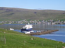
228:
99:
266:
129:
79:
45:
212:
255:
208:
60:
200:
83:
103:
95:
91:
87:
71:
41:
56:
177:
164:
64:
23:
132:, Tvøroyrar Kommuna vunnið sakarmálið í Føroya Rætti um havnargjald (
32:
18:
154:
48:. Krambatangi ferry port is on the southern side of the fjord.
216:
149:
94:, and there have been some disagreements between the
70:M/F disembarks 2–3 times daily from Krambatangi to
74:. Krambatangi is located on the southern side of
29:leaving Krambatangi ferryport on 19 June 2010.
236:
8:
243:
229:
16:Ferry port of Suðuroy in the Faroe Islands
262:Ports and harbours of the Faroe Islands
115:
7:
197:
195:
14:
199:
106:, but SSL appealed the verdict.
1:
272:Faroe Islands geography stubs
215:. You can help Knowledge by
288:
194:
100:Strandfaraskip Landsins
211:location article is a
49:
30:
55:is the ferry port of
36:
22:
174: /
178:61.5481°N 6.8185°W
128:2010-06-17 at the
76:Trongisvágsfjørður
50:
38:Trongisvágsfjørður
31:
224:
223:
98:municipality and
279:
245:
238:
231:
203:
196:
189:
188:
186:
185:
184:
183:61.5481; -6.8185
179:
175:
172:
171:
170:
167:
137:
120:
78:halfway between
287:
286:
282:
281:
280:
278:
277:
276:
252:
251:
250:
249:
192:
182:
180:
176:
173:
168:
165:
163:
161:
160:
155:Visitsuduroy.fo
146:
141:
140:
130:Wayback Machine
121:
117:
112:
17:
12:
11:
5:
285:
283:
275:
274:
269:
264:
254:
253:
248:
247:
240:
233:
225:
222:
221:
204:
158:
157:
152:
145:
144:External links
142:
139:
138:
114:
113:
111:
108:
15:
13:
10:
9:
6:
4:
3:
2:
284:
273:
270:
268:
265:
263:
260:
259:
257:
246:
241:
239:
234:
232:
227:
226:
220:
218:
214:
210:
209:Faroe Islands
205:
202:
198:
193:
190:
187:
156:
153:
151:
148:
147:
143:
135:
131:
127:
124:
123:Sudurras1.com
119:
116:
109:
107:
105:
101:
97:
93:
89:
85:
81:
77:
73:
69:
68:
62:
61:Faroe Islands
58:
54:
47:
43:
39:
35:
28:
27:
21:
217:expanding it
206:
191:
159:
133:
118:
80:Trongisvágur
66:
63:. The ferry
52:
51:
46:Trongisvágur
25:
181: /
86:, opposite
53:Krambatangi
256:Categories
166:61°32′53″N
134:in Faroese
110:References
169:6°49′07″W
126:Archived
104:Tvøroyri
96:Tvøroyri
92:Tvøroyri
88:Tvøroyri
72:Tórshavn
42:Tvøroyri
267:Suðuroy
59:in the
57:Suðuroy
150:SSL.fo
84:Øravík
67:Smyril
26:Smyril
207:This
213:stub
82:and
44:and
65:MS
24:MS
258::
40:,
244:e
237:t
230:v
219:.
136:)
Text is available under the Creative Commons Attribution-ShareAlike License. Additional terms may apply.
↑