89:
59:
383:
119:
40:
126:
96:
66:
322:. Its surface area is 0.35 square kilometres (35 ha; 86 acres). The dam was built in 1872, and its height was increased by 2.5 metres (8.2 ft) in 1910. The watershed (or catchment) is 1,250 square kilometres (480 sq mi). The Maigrauge Dam has a gated spillway.
169:
428:
365:
472:
88:
58:
457:
345:
447:
421:
467:
118:
414:
227:
462:
394:
213:
155:
452:
398:
342:
349:
251:
241:
39:
382:
441:
201:
311:
234:
220:
319:
184:
171:
206:
315:
151:
17:
214:
228:
390:
341:"Swiss Committee on Dams - Maigrauge", Swissdams.ch, 2008,
402:
297:
289:
281:
273:
265:
261:
250:
240:
226:
212:
200:
161:
147:
32:
162:
422:
8:
285:400,000 m (14,000,000 cu ft)
429:
415:
29:
27:Reservoir in Fribourg, Canton of Fribourg
331:
125:
95:
65:
337:
335:
7:
379:
377:
366:Réserve naturelle du lac de Pérolles
277:0.35 km (35 ha; 86 acres)
246:1,250 km (480 sq mi)
473:Canton of Fribourg geography stubs
401:. You can help Knowledge (XXG) by
45:View near Maigrauge Dam (at right)
25:
381:
124:
117:
94:
87:
64:
57:
38:
458:Lakes of the canton of Fribourg
288:
280:
272:
264:
78:Show map of Canton of Fribourg
1:
146:
293:553.3 m (1,815 ft)
489:
389:This article related to a
376:
448:Reservoirs in Switzerland
269:2.3 km (1.4 mi)
51:
37:
310:, is a reservoir on the
306:, a reservoir formed by
185:46.7959167°N 7.1625972°E
108:Show map of Switzerland
468:Switzerland lake stubs
190:46.7959167; 7.1625972
181: /
395:canton of Fribourg
348:2010-07-15 at the
156:Canton of Fribourg
410:
409:
301:
300:
290:Surface elevation
16:(Redirected from
480:
431:
424:
417:
385:
378:
370:
353:
339:
230:
229:Primary outflows
216:
196:
195:
193:
192:
191:
186:
182:
179:
178:
177:
174:
164:
139:
138:Show map of Alps
128:
127:
121:
109:
98:
97:
91:
79:
68:
67:
61:
46:
42:
30:
21:
488:
487:
483:
482:
481:
479:
478:
477:
438:
437:
436:
435:
374:
368:
362:
357:
356:
350:Wayback Machine
340:
333:
328:
304:Lac de Pérolles
254: countries
215:Primary inflows
189:
187:
183:
180:
175:
172:
170:
168:
167:
143:
142:
141:
140:
137:
136:
135:
134:
133:
132:Lac de Pérolles
129:
112:
111:
110:
107:
106:
105:
104:
103:
102:Lac de Pérolles
99:
82:
81:
80:
77:
76:
75:
74:
73:
72:Lac de Pérolles
69:
47:
44:
33:Lac de Pérolles
28:
23:
22:
15:
12:
11:
5:
486:
484:
476:
475:
470:
465:
460:
455:
450:
440:
439:
434:
433:
426:
419:
411:
408:
407:
386:
372:
371:
361:
360:External links
358:
355:
354:
330:
329:
327:
324:
299:
298:
295:
294:
291:
287:
286:
283:
279:
278:
275:
271:
270:
267:
263:
262:
259:
258:
255:
248:
247:
244:
242:Catchment area
238:
237:
232:
224:
223:
218:
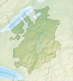
210:
209:
204:
198:
197:
165:
159:
158:
149:
145:
144:
131:
130:
123:
122:
116:
115:
114:
113:
101:
100:
93:
92:
86:
85:
84:
83:
71:
70:
63:
62:
56:
55:
54:
53:
52:
49:
48:
43:
35:
34:
26:
24:
14:
13:
10:
9:
6:
4:
3:
2:
485:
474:
471:
469:
466:
464:
461:
459:
456:
454:
451:
449:
446:
445:
443:
432:
427:
425:
420:
418:
413:
412:
406:
404:
400:
396:
392:
387:
384:
380:
375:
367:
364:
363:
359:
351:
347:
344:
338:
336:
332:
325:
323:
321:
318:, in western
317:
313:
309:
308:Maigrauge Dam
305:
296:
292:
284:
276:
268:
260:
256:
253:
249:
245:
243:
239:
236:
233:
231:
225:
222:
219:
217:
211:
208:
205:
203:
199:
194:
173:46°47′45.30″N
166:
160:
157:
153:
150:
120:
90:
60:
50:
41:
36:
31:
19:
403:expanding it
388:
373:
312:Saane/Sarine
307:
303:
302:
282:Water volume
274:Surface area
235:Saane/Sarine
221:Saane/Sarine
463:Saane basin
369:(in French)
320:Switzerland
266:Max. length
257:Switzerland
188: /
176:7°9′45.35″E
163:Coordinates
442:Categories
343:SD-dam-103
326:References
314:river at
207:reservoir
18:Maigrauge
453:Fribourg
346:Archived
316:Fribourg
152:Fribourg
148:Location
393:in the
397:is a
252:Basin
399:stub
391:lake
202:Type
444::
334:^
154:,
430:e
423:t
416:v
405:.
352:.
20:)
Text is available under the Creative Commons Attribution-ShareAlike License. Additional terms may apply.
↑