425:
242:
151:
40:
313:
424:
328:
to the west of the main range are technically classified as part of the
Monashees, however, they may also be considered part of the Interior Plateau. The Okanagan Highland lies between the
667:
Fifth Annual Report of the
Minister of Mines for the Year Ending 31st December, 1917. Being an Account of Mining Operations for Gold, Coal, Etc., in the Province of British Columbia
652:
352:
to the
Okanagan Highland, may also be included. Major peaks include Hallam Peak (3,205 m (10,515 ft)) and Cranberry Mountain (2,872 m (9,423 ft)).
769:
297:, and reaches west to the southern extremity of the Okanagan Highland (spelled Okanogan Highland in the US) just northeast of the confluence of the
90:
290:
1379:
218:. They stretch 530 km (329 mi) from north to south and 150 km (93 mi) from east to west. They are a sub-range of the
545:
484:
341:
274:
762:
1179:
396:. The southern end of the Monashees within Canada is an historically important mining and former industrial area known as the
1332:
628:
1026:
1005:
561:
329:
241:
1235:
886:
680:
377:
361:
83:
1374:
1369:
755:
851:
381:
365:
1036:
881:
836:
413:
405:
44:
Monashee
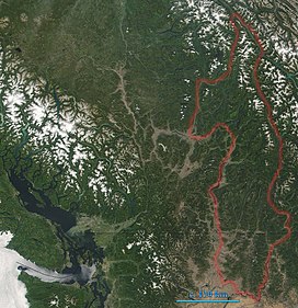
Mountains are indicated. In the left of the image lies Vancouver Island. The boundary here includes the
373:
846:
534:
891:
306:
222:. The highest summit is Mount Monashee, which reaches 3,274 m (10,741 ft). The name is from the
1346:
1271:
866:
856:
841:
727:
588:
1261:
1174:
896:
876:
861:
540:
409:
369:
349:
302:
150:
1306:
1240:
949:
778:
646:
457:
428:
286:
219:
215:
174:
1296:
1145:
1055:
871:
791:
634:
624:
472:
389:
321:
262:
45:
1301:
1281:
1266:
1169:
934:
617:
504:
477:
397:
325:
270:
203:
170:
49:
400:, which is focused around the basin of the lower Kettle River and extends north toward the
1199:
1164:
1110:
964:
820:
489:
442:
416:, 5,575 feet (1,699 m), the highest mountain pass open all year in Washington state.
285:, British Columbia. The southern extremity of the range is in Washington State, where the
223:
979:
969:
582:
509:
494:
298:
294:
266:
254:
246:
199:
181:
66:
1363:
1327:
1311:
1225:
1220:
1189:
1184:
1095:
1090:
1069:
1031:
815:
805:
722:
594:
385:
337:
333:
278:
1204:
1194:
1159:
1126:
1105:
1100:
1074:
1021:
959:
954:
944:
929:
576:
467:
462:
452:
437:
401:
393:
39:
1245:
1230:
1000:
974:
708:
528:
499:
258:
1286:
1276:
939:
810:
447:
345:
211:
412:
across the center of the Kettle River Range and reaches its highest point at
105:
92:
1291:
995:
638:
312:
282:
742:
688:
17:
546:
747:
207:
73:
311:
240:
1143:
1053:
913:
789:
751:
348:
to the west. The portion of the
Shuswap Highland south of the
623:. Akrigg, Helen B. (3rd ed.). Victoria, BC: UBC Press.
669:. The Government of the Province of British Columbia. 1917.
344:
lies between the uppermost
Shuswap River to the east and
253:
The
Monashee Mountains are limited on the east by the
1341:
1320:
1254:
1213:
1152:
1119:
1083:
1062:
1014:
988:
922:
829:
798:
245:Monashee Mountains, in the distance on the left of
180:
166:
158:
142:
134:
126:
121:
82:
72:
62:
57:
32:
616:
408:runs 40 miles (64 km) east from the town of
570:Cranberry Mountain, 2,872 m (9,423 ft)
555:Dominion Mountain, 3,131 m (10,272 ft)
567:Gordon Horne Peak, 2,881 m (9,452 ft)
558:Peak 2892, 2,982 m (9,783 ft)
525:Mount Monashee, 3,274 m (10,741 ft)
763:
316:Mt. Albreda and Clemina Creek, Monashee Range
8:
651:: CS1 maint: multiple names: authors list (
265:. They are limited on the west by the upper
573:The Pinnacles, 2,607 m (8,553 ft)
1140:
1050:
910:
786:
770:
756:
748:
364:and Shuswap Lake, the range is crossed by
29:
431:(2376m), highest point of Rossland Range
423:
607:
27:Mountain range in the country of Canada
644:
7:
579:, 2,733 m (8,967 ft)
273:. The northern end of the range is
743:Bivouac.com Hiking info and images
25:
552:, 3,205 m (10,515 ft)
130:530 km (330 mi) N-S
585:, 2,556 m (8,386 ft)
149:
138:150 km (93 mi) W-E
38:
597:, 3,052 m (10,013 ft)
531:, 3,205 m (10,515 ft)
340:. Within this area, the small
591:, 2,649 m (8,691 ft)
564:, 2,971 m (9,747 ft)
537:, 1,591 m (5,220 ft)
289:reaches the confluence of the
1:
372:- and by the mainline of the
78:3,274 m (10,741 ft)
1380:Interior of British Columbia
709:Peakbagger.com, Peaks List:
619:British Columbia place names
233:meaning "moor" and "peace".
1396:
615:V., Akrigg, G. P. (1997).
1139:
1049:
909:
785:
683:Sherman Pass Scenic Byway
406:Sherman Pass Scenic Byway
147:
37:
374:Canadian Pacific Railway
277:at the south end of the
162:Canada and United States
535:Red Mountain (Rossland)
392:to the south takes the
301:and Columbia rivers at
261:, beyond which lie the
887:Pierre Elliott Trudeau
432:
317:
307:Bridgeport, Washington
281:, near of the town of
250:
106:52.38528°N 118.94000°W
728:BC Geographical Names
427:
315:
244:
210:, extending into the
852:Sir Mackenzie Bowell
723:"Monashee Mountains"
410:Republic, Washington
376:, which run through
370:Trans-Canada Highway
350:North Thompson River
267:North Thompson River
111:52.38528; -118.94000
48:and portions of the
882:Louis Saint Laurent
837:Sir Wilfrid Laurier
681:"America's Byways,
102: /
1375:Columbia Mountains
1370:Monashee Mountains
779:Columbia Mountains
711:Monashee Mountains
458:Kettle River Range
433:
429:Old Glory Mountain
318:
287:Kettle River Range
251:
220:Columbia Mountains
196:Monashee Mountains
188:Columbia Mountains
58:Highest point
33:Monashee Mountains
1357:
1356:
1353:
1352:
1135:
1134:
1045:
1044:
905:
904:
847:Sir John Thompson
473:Okanagan Highland
390:Crowsnest Highway
324:and parts of the
322:Okanagan Highland
263:Selkirk Mountains
192:
191:
46:Okanagan Highland
16:(Redirected from
1387:
1141:
1051:
911:
892:Sir Allan MacNab
787:
772:
765:
758:
749:
732:
714:
706:
700:
699:
697:
696:
687:. Archived from
677:
671:
670:
663:
657:
656:
650:
642:
622:
612:
551:
548:
505:Shuswap Highland
478:Beaverdell Range
398:Boundary Country
326:Shuswap Highland
271:Interior Plateau
204:British Columbia
202:lying mostly in
184:
171:British Columbia
167:Provinces/States
153:
117:
116:
114:
113:
112:
107:
103:
100:
99:
98:
95:
50:Shuswap Highland
42:
30:
21:
1395:
1394:
1390:
1389:
1388:
1386:
1385:
1384:
1360:
1359:
1358:
1349:
1337:
1316:
1250:
1209:
1148:
1131:
1115:
1111:Snowpatch Spire
1079:
1058:
1041:
1010:
984:
918:
901:
867:Richard Bennett
857:Stanley Baldwin
842:Sir John Abbott
825:
794:
781:
776:
739:
721:
718:
717:
707:
703:
694:
692:
679:
678:
674:
665:
664:
660:
643:
631:
614:
613:
609:
604:
543:
541:Mount Lempriere
519:
514:
490:Ratchford Range
443:Christina Range
422:
358:
336:, south of the
239:
224:Scottish Gaelic
182:
154:
110:
108:
104:
101:
96:
93:
91:
89:
88:
53:
28:
23:
22:
15:
12:
11:
5:
1393:
1391:
1383:
1382:
1377:
1372:
1362:
1361:
1355:
1354:
1351:
1350:
1345:
1343:
1339:
1338:
1336:
1335:
1330:
1324:
1322:
1318:
1317:
1315:
1314:
1309:
1304:
1299:
1294:
1289:
1284:
1279:
1274:
1269:
1264:
1258:
1256:
1252:
1251:
1249:
1248:
1243:
1238:
1233:
1228:
1223:
1217:
1215:
1211:
1210:
1208:
1207:
1202:
1197:
1192:
1187:
1182:
1177:
1175:Clachnacudainn
1172:
1167:
1162:
1156:
1154:
1150:
1149:
1144:
1137:
1136:
1133:
1132:
1130:
1129:
1123:
1121:
1117:
1116:
1114:
1113:
1108:
1103:
1098:
1093:
1087:
1085:
1081:
1080:
1078:
1077:
1072:
1066:
1064:
1060:
1059:
1054:
1047:
1046:
1043:
1042:
1040:
1039:
1034:
1029:
1024:
1018:
1016:
1012:
1011:
1009:
1008:
1003:
998:
992:
990:
986:
985:
983:
982:
977:
972:
967:
962:
957:
952:
947:
942:
937:
932:
926:
924:
920:
919:
914:
907:
906:
903:
902:
900:
899:
897:Mackenzie King
894:
889:
884:
879:
877:Lester Pearson
874:
869:
864:
862:Arthur Meighen
859:
854:
849:
844:
839:
833:
831:
827:
826:
824:
823:
818:
813:
808:
802:
800:
796:
795:
790:
783:
782:
777:
775:
774:
767:
760:
752:
746:
745:
738:
737:External links
735:
734:
733:
716:
715:
701:
672:
658:
629:
606:
605:
603:
600:
599:
598:
592:
586:
583:Mount Copeland
580:
574:
571:
568:
565:
559:
556:
553:
538:
532:
526:
518:
515:
513:
512:
510:Whatshan Range
507:
502:
497:
495:Rossland Range
492:
487:
485:Sawtooth Range
482:
481:
480:
470:
465:
460:
455:
450:
445:
440:
434:
421:
418:
357:
354:
342:Sawtooth Range
275:Canoe Mountain
255:Columbia River
247:Kinbasket Lake
238:
235:
200:mountain range
190:
189:
186:
178:
177:
168:
164:
163:
160:
156:
155:
148:
145:
144:
140:
139:
136:
132:
131:
128:
124:
123:
119:
118:
86:
80:
79:
76:
70:
69:
67:Mount Monashee
64:
60:
59:
55:
54:
43:
35:
34:
26:
24:
14:
13:
10:
9:
6:
4:
3:
2:
1392:
1381:
1378:
1376:
1373:
1371:
1368:
1367:
1365:
1348:
1347:Illecillewaet
1344:
1340:
1334:
1331:
1329:
1326:
1325:
1323:
1319:
1313:
1310:
1308:
1305:
1303:
1300:
1298:
1295:
1293:
1290:
1288:
1285:
1283:
1280:
1278:
1275:
1273:
1270:
1268:
1265:
1263:
1260:
1259:
1257:
1253:
1247:
1244:
1242:
1239:
1237:
1234:
1232:
1229:
1227:
1224:
1222:
1219:
1218:
1216:
1212:
1206:
1203:
1201:
1198:
1196:
1193:
1191:
1188:
1186:
1183:
1181:
1178:
1176:
1173:
1171:
1168:
1166:
1163:
1161:
1158:
1157:
1155:
1151:
1147:
1142:
1138:
1128:
1125:
1124:
1122:
1118:
1112:
1109:
1107:
1104:
1102:
1099:
1097:
1096:Bugaboo Spire
1094:
1092:
1089:
1088:
1086:
1082:
1076:
1073:
1071:
1070:Farnham Group
1068:
1067:
1065:
1061:
1057:
1052:
1048:
1038:
1035:
1033:
1030:
1028:
1025:
1023:
1020:
1019:
1017:
1013:
1007:
1004:
1002:
999:
997:
994:
993:
991:
987:
981:
978:
976:
973:
971:
968:
966:
963:
961:
958:
956:
953:
951:
948:
946:
943:
941:
938:
936:
933:
931:
928:
927:
925:
921:
917:
912:
908:
898:
895:
893:
890:
888:
885:
883:
880:
878:
875:
873:
870:
868:
865:
863:
860:
858:
855:
853:
850:
848:
845:
843:
840:
838:
835:
834:
832:
828:
822:
819:
817:
814:
812:
809:
807:
804:
803:
801:
797:
793:
788:
784:
780:
773:
768:
766:
761:
759:
754:
753:
750:
744:
741:
740:
736:
730:
729:
724:
720:
719:
713:
712:
705:
702:
691:on 2007-03-20
690:
686:
684:
676:
673:
668:
662:
659:
654:
648:
640:
636:
632:
626:
621:
620:
611:
608:
601:
596:
595:Mount Albreda
593:
590:
587:
584:
581:
578:
575:
572:
569:
566:
563:
560:
557:
554:
549:
542:
539:
536:
533:
530:
527:
524:
523:
522:
516:
511:
508:
506:
503:
501:
498:
496:
493:
491:
488:
486:
483:
479:
476:
475:
474:
471:
469:
466:
464:
461:
459:
456:
454:
451:
449:
446:
444:
441:
439:
436:
435:
430:
426:
419:
417:
415:
411:
407:
403:
399:
395:
391:
387:
386:Monashee Pass
383:
379:
375:
371:
367:
363:
355:
353:
351:
347:
343:
339:
338:Shuswap River
335:
334:Okanagan Lake
331:
327:
323:
314:
310:
308:
304:
300:
296:
292:
288:
284:
280:
279:Robson Valley
276:
272:
268:
264:
260:
256:
248:
243:
236:
234:
232:
228:
225:
221:
217:
213:
209:
205:
201:
197:
187:
185:
179:
176:
172:
169:
165:
161:
157:
152:
146:
141:
137:
133:
129:
125:
120:
115:
87:
85:
81:
77:
75:
71:
68:
65:
61:
56:
51:
47:
41:
36:
31:
19:
1307:Sir Sandford
1297:North Albert
1241:Sir Sandford
1153:Major ranges
1106:Pigeon Spire
1101:Howser Spire
1075:The Bugaboos
950:Kettle River
923:Major ranges
915:
799:Major ranges
726:
710:
704:
693:. Retrieved
689:the original
682:
675:
666:
661:
618:
610:
589:Mount Tilley
577:Mount Begbie
520:
468:Midway Range
463:Malton Range
453:Jordan Range
438:Anstey Range
414:Sherman Pass
402:Midway Range
394:Bonanza Pass
359:
330:Kettle River
319:
291:Kettle River
252:
230:
226:
195:
193:
183:Parent range
1262:Abercrombie
872:John Oliver
544: [
529:Hallam Peak
500:Scrip Range
259:Arrow Lakes
109: /
97:118°56′24″W
84:Coordinates
1364:Categories
1302:Sir Donald
1287:Krell Hill
1282:Kit Carson
1277:Gypsy Peak
1214:Sub-ranges
1170:Bonnington
1063:Sub-ranges
935:Beaverdell
695:2017-12-25
630:0774806362
562:Mount Odin
448:Gold Range
384:goes over
378:Eagle Pass
362:Revelstoke
346:Mabel Lake
216:Washington
212:U.S. state
175:Washington
122:Dimensions
94:52°23′07″N
1292:Mica Peak
1255:Mountains
1084:Mountains
989:Mountains
965:Ratchford
830:Mountains
821:Christina
647:cite book
517:Mountains
420:Subranges
382:Highway 6
366:Highway 1
283:Valemount
237:Geography
159:Countries
143:Geography
74:Elevation
1342:Glaciers
1328:Kootenay
1200:Valhalla
1165:Big Bend
1120:Glaciers
1032:Monashee
980:Whatshan
970:Rossland
916:Monashee
639:41086359
547:Wikidata
521:Source:
360:Between
303:Brewster
299:Okanogan
295:Columbia
293:and the
269:and the
18:Monashee
1312:Spokane
1267:Adamant
1226:Badshot
1221:Adamant
1190:Kokanee
1146:Selkirk
1091:Farnham
1056:Purcell
1037:Sherman
1022:Bonanza
816:Premier
806:Mowdish
792:Cariboo
602:Sources
1333:Rogers
1321:Passes
1272:Dawson
1205:Valkyr
1195:Nelson
1185:Duncan
1180:Dawson
1160:Battle
1015:Passes
1001:Hallam
960:Midway
955:Malton
945:Jordan
930:Anstey
637:
627:
404:. The
388:. The
368:- the
356:Passes
227:monadh
208:Canada
198:are a
127:Length
1246:Windy
1231:Norns
1027:Eagle
975:Scrip
550:]
231:sìth,
135:Width
1236:Ruby
1127:Toby
1006:Odin
996:Dunn
940:Gold
811:Wavy
653:link
635:OCLC
625:ISBN
332:and
320:The
305:and
257:and
229:and
194:The
173:and
63:Peak
214:of
1366::
725:.
649:}}
645:{{
633:.
380:.
309:.
206:,
771:e
764:t
757:v
731:.
698:.
685:"
655:)
641:.
249:.
52:.
20:)
Text is available under the Creative Commons Attribution-ShareAlike License. Additional terms may apply.