107:
20:
63:
268:
139:, states that the rock appeared to wear a hood over its "head," similar to that of a monk, as well as the fact that it provides safe refuge for those caught in a storm. The article mentions that the monk was 70 feet (21 metres) high. Munkurin is now 11 metres high, but it used to be higher. It collapsed in 1884-85. Before it collapsed, the
129:, written in 1800, that when seen from the land, the rock island presented the appearance of a monk with a red neck and a dark grey body and head, and from the sea, it looked like a ship under full sails. Another source, that of
147:) used to nest there, but since it collapsed, the birds don't nest there anymore; they nest in Mykineshólmur. It happens sometimes that the rock looks white from the land, and that is because there are many
333:
193:
309:
343:
134:
338:
328:
174:
229:
302:
117:
The rocks are close together except for
Munkurin, which is a little further away, which is possibly why it is called the
106:
295:
30:
is the southernmost point of the Faroe
Islands. Munkurin is an 11-metre-high rock, also known as
164:. The German book is translated from Danish. Writer: C. G. Mengel, Copenhagen / Leipzig, 1757.
19:
279:
62:
148:
140:
126:
322:
275:
47:
121:. Two sources mention another reason for the name Munkurin, referring to before the
130:
267:
23:
The sea stack
Munkurin as a motif on a Faroese stamp, drawn before it collapsed.
78:
51:
43:
244:
231:
221:
74:
67:
66:
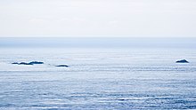
Flesjarnar, Munkurin is to the right on this photo, which was taken from
39:
122:
105:
61:
18:
118:
35:
216:
125:
collapsed. The article tells about the observations of Pastor
88:
Miðjufles, 4 metres high (the word miðju means in the middle)
73:
Flesjarnar are a group of rocks, located 5 km south of
283:
206:
Also based on the German version of
Knowledge (XXG).
42:
194:
Wikisource.org, Popular
Science Monthly, Volume 30.
162:
Natürliche und
Politische Historie der Inseln Färöe
303:
8:
94:Stórafles, 7 metres high (Stóra means large)
85:Sumbiarfles, 4 metres high (nearest to land)
310:
296:
97:Munkurin or Sumbiarsteinur, 11 metres high
334:Uninhabited islands of the Faroe Islands
186:
16:Southernmost point of the Faroe Islands
112:A Description of the Northern Peoples.
136:Histora de Gentibus Septentrionalibus
54:is notorious for its strong current.
7:
264:
262:
222:Photos on Flickr related to Munkurin
91:Bøllufles, 6 metres high (two rocks)
175:Extreme points of the Faroe Islands
50:. The sound between Flesjarnar and
282:. You can help Knowledge (XXG) by
14:
38:". The rock is one of a group of
266:
155:Literature in German and Danish
110:An excerpt from Olaus Magnus'
1:
344:Faroe Islands geography stubs
339:Stacks of the Faroe Islands
329:Islets of the Faroe Islands
360:
261:
203:A Map of the Faroe Islands
278:location article is a
160:Lucas Jacobson Debes:
114:
70:
24:
109:
65:
22:
241: /
115:
71:
25:
291:
290:
81:. The rocks are:
351:
312:
305:
298:
270:
263:
256:
255:
253:
252:
251:
246:
245:61.333°N 6.667°W
242:
239:
238:
237:
234:
196:
191:
149:northern gannets
34:. Munkur means "
359:
358:
354:
353:
352:
350:
349:
348:
319:
318:
317:
316:
259:
249:
247:
243:
240:
235:
232:
230:
228:
227:
217:Visitsuduroy.fo
213:
200:
199:
192:
188:
183:
171:
157:
151:sitting there.
141:northern gannet
104:
60:
17:
12:
11:
5:
357:
355:
347:
346:
341:
336:
331:
321:
320:
315:
314:
307:
300:
292:
289:
288:
271:
250:61.333; -6.667
225:
224:
219:
212:
211:External links
209:
208:
207:
204:
198:
197:
185:
184:
182:
179:
178:
177:
170:
167:
166:
165:
156:
153:
145:Morus bassanus
103:
100:
99:
98:
95:
92:
89:
86:
59:
56:
32:Sumbiarsteinur
15:
13:
10:
9:
6:
4:
3:
2:
356:
345:
342:
340:
337:
335:
332:
330:
327:
326:
324:
313:
308:
306:
301:
299:
294:
293:
287:
285:
281:
277:
276:Faroe Islands
272:
269:
265:
260:
257:
254:
223:
220:
218:
215:
214:
210:
205:
202:
201:
195:
190:
187:
180:
176:
173:
172:
168:
163:
159:
158:
154:
152:
150:
146:
142:
138:
137:
132:
128:
124:
120:
113:
108:
101:
96:
93:
90:
87:
84:
83:
82:
80:
76:
69:
64:
57:
55:
53:
49:
48:Faroe Islands
45:
41:
37:
33:
29:
21:
284:expanding it
273:
258:
226:
189:
161:
144:
135:
131:Olaus Magnus
127:Jørgen Landt
116:
111:
72:
31:
27:
26:
248: /
323:Categories
181:References
58:Flesjarnar
169:See also
102:Munkurin
75:Akraberg
68:Akraberg
40:skerries
28:Munkurin
233:61°20′N
79:Suðuroy
52:Suðuroy
46:in the
44:Suðuroy
236:6°40′W
274:This
123:islet
280:stub
119:Monk
36:monk
133:'s
77:in
325::
311:e
304:t
297:v
286:.
143:(
Text is available under the Creative Commons Attribution-ShareAlike License. Additional terms may apply.