298:
130:
137:
297:
234:
29:
249:
The northern wall is not a uniform surface, dissected by ledges, dihedrals, and ramps. The main access route to the summit leads through one of the ramps to the saddle between the main summit and its western trabant. The passage on the top cone is secured by ropes for unprepared tourists.
241:
The
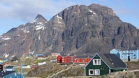
Nasaasaaq ridge has several summits. The main summit is the most prominent, rising over the remainder of the ridge in a tall 150 m (490 ft) cone at 784 m (2,572 ft). The ridge terminates in a 611 m (2,005 ft) trabant overlooking Sisimiut.
262:
to the north of the town airport. An alternative route to the top of interest to mountaineers leads through the hard-to-find low pass to the east of the main summit, and from there directly on the summit cone ridge.
245:
To the east the ridge gradually falls to nearly 300 m (980 ft), before turning east-north-east towards the
Aappilattorsuaq massif. The southern wall of Nasaasaaq falls directly to Amerloq Fjord.
225:, due to pressure exerted by the icesheet for long periods in the past. The Nasaasaaq ridge connects to the other latitudinal ridges approximately 15 km (9.3 mi) east of Sisimiut.
201:
The mountain massif is spread out over 6 kilometres (3.7 mi) in the west–east direction, constituting the terminal point of a long mountain range extending from the
304:
129:
86:
394:
465:
432:
72:
279:
from
Sisimiut to Kangerlussuaq. The race was inaugurated in 1998, since then becoming an international competition. The
79:
310:
258:
The main summit is visited for its long-range view of the coast, although more limited to the north than that of
287:
mountain to the north, with the summit of the latter sometimes visited by way of a variant. A small lift for
321:. Left to right: the summit cone of Nasaasaaq, the saddle between the main summit and the western trabant.
57:
460:
318:
218:
202:
210:
206:
67:
470:
390:
314:
167:
363:
259:
33:
The western (right) and main (left) summits of
Nasaasaaq seen from the northwest, from
454:
307:
288:
222:
191:
284:
195:
352:(Map) (1996 ed.). Cartography by Compukort, Denmark. Greenland Tourism a/s.
313:
flying just north of the summit of
Nasaasaaq, descending over Sisimiut towards
233:
186:. It is located on the mainland of Greenland, immediately to the southeast of
101:
88:
183:
150:
410:
187:
175:
34:
275:
takes place each winter, with the trail partially overlapping with the
179:
28:
47:
217:). The range flattens considerably towards the east in the area of
232:
283:
passes through the saddle between
Nasaasaaq and the much lower
435:. The Official Tourism and Business Site of Greenland
205:
mountain group halfway between Davis Strait and the
117:
78:
66:
56:
46:
41:
21:
174:) is a 784-metre-high (2,572 ft) prominent
8:
271:The tough, 160-kilometre-long (99 mi)
18:
332:
237:Aerial view of Nasaasaaq from the west
344:
342:
340:
338:
336:
7:
14:
350:Vandrekort Vestgrønland: Sisimiut
291:is also installed on the saddle.
136:
296:
135:
128:
27:
389:. Lonely Planet. p. 160.
364:"Sisimiut Tourist Information"
73:List of mountains in Greenland
1:
487:
311:de Havilland Canada Dash-7
62:784 m (2,572 ft)
52:784 m (2,572 ft)
385:O'Carroll, Etain (2005).
190:on the northern coast of
122:
26:
387:Greenland and the Arctic
182:municipality in western
317:during its flight from
466:Mountains of Greenland
238:
214:
171:
319:Kangerlussuaq Airport
236:
219:Kangaamiut dike swarm
102:66.92639°N 53.55278°W
16:Mountain in Greenland
433:"Arctic Circle Race"
413:. Arctic Circle Race
207:Greenland ice sheet
107:66.92639; -53.55278
98: /
273:Arctic Circle Race
239:
42:Highest point
366:. Greenland Guide
194:, a tributary of
161:
160:
478:
445:
444:
442:
440:
429:
423:
422:
420:
418:
407:
401:
400:
382:
376:
375:
373:
371:
360:
354:
353:
346:
315:Sisimiut Airport
300:
139:
138:
132:
113:
112:
110:
109:
108:
103:
99:
96:
95:
94:
91:
31:
19:
486:
485:
481:
480:
479:
477:
476:
475:
451:
450:
449:
448:
438:
436:
431:
430:
426:
416:
414:
409:
408:
404:
397:
384:
383:
379:
369:
367:
362:
361:
357:
348:
347:
334:
329:
324:
323:
322:
306:
301:
289:downhill skiing
269:
256:
231:
157:
156:
155:
154:
153:
147:
146:
145:
144:
140:
106:
104:
100:
97:
92:
89:
87:
85:
84:
37:
17:
12:
11:
5:
484:
482:
474:
473:
468:
463:
453:
452:
447:
446:
424:
402:
395:
377:
355:
331:
330:
328:
325:
303:
302:
295:
294:
293:
268:
265:
260:Palasip Qaqqaa
255:
252:
230:
227:
172:Kællingehætten
159:
158:
148:
142:
141:
134:
133:
127:
126:
125:
124:
123:
120:
119:
115:
114:
82:
76:
75:
70:
64:
63:
60:
54:
53:
50:
44:
43:
39:
38:
32:
24:
23:
15:
13:
10:
9:
6:
4:
3:
2:
483:
472:
469:
467:
464:
462:
459:
458:
456:
434:
428:
425:
412:
406:
403:
398:
396:1-74059-095-3
392:
388:
381:
378:
365:
359:
356:
351:
345:
343:
341:
339:
337:
333:
326:
320:
316:
312:
309:
308:Air Greenland
305:
299:
292:
290:
286:
282:
278:
274:
266:
264:
261:
253:
251:
247:
243:
235:
228:
226:
224:
223:Kangerlussuaq
220:
216:
212:
208:
204:
199:
197:
193:
192:Amerloq Fjord
189:
185:
181:
177:
173:
169:
165:
152:
131:
121:
116:
111:
83:
81:
77:
74:
71:
69:
65:
61:
59:
55:
51:
49:
45:
40:
36:
30:
25:
20:
461:Davis Strait
437:. Retrieved
427:
415:. Retrieved
411:"Race setup"
405:
386:
380:
368:. Retrieved
358:
349:
285:Alanngorsuaq
280:
276:
272:
270:
257:
248:
244:
240:
200:
196:Davis Strait
163:
162:
149:Mainland of
281:Polar Route
277:Polar Route
267:Polar Route
211:Greenlandic
105: /
80:Coordinates
455:Categories
327:References
229:Topography
215:Sermersuaq
93:53°33′10″W
90:66°55′35″N
58:Prominence
221:north of
184:Greenland
164:Nasaasaaq
151:Greenland
143:Nasaasaaq
118:Geography
48:Elevation
22:Nasaasaaq
471:Sisimiut
188:Sisimiut
176:mountain
35:Sisimiut
439:11 July
417:11 July
254:Tourism
180:Qeqqata
178:in the
68:Listing
393:
370:5 July
168:Danish
203:Pingu
441:2010
419:2010
391:ISBN
372:2010
457::
335:^
213::
198:.
170::
166:(
443:.
421:.
399:.
374:.
209:(
Text is available under the Creative Commons Attribution-ShareAlike License. Additional terms may apply.