51:
384:. There were 735 households, comprising 1,089 males and 1,062 females, giving a sex ratio of 1.03 males per female. The median age was 43.1 years (compared with 37.4 years nationally), with 387 people (18.0%) aged under 15 years, 360 (16.8%) aged 15 to 29, 1,098 (51.1%) aged 30 to 64, and 300 (14.0%) aged 65 or older.
432:
Of those at least 15 years old, 489 (27.8%) people had a bachelor's or higher degree, and 210 (11.9%) people had no formal qualifications. The median income was $ 42,300, compared with $ 31,800 nationally. 495 people (28.1%) earned over $ 70,000 compared to 17.2% nationally. The employment status of
461:
The
Waiatarua area includes the Upper and Lower Nihotupu water reservoirs. Leading to these reservoirs are scenic walking trails through native forest past waterfalls. These trails connect with the wider network of walking trails within Waitakere Regional Park. Many other tramping tracks are in the
295:
Rose
Hellaby House is a historic building transformed into a museum. Large Kauri trees were milled in Waiatarua at Mander and Bradley's Mill close to Upper Nihotupu reservoir. At the turn of the century, holidaymakers would travel by coach from
247:
and
Mountain Road. Surrounded by native bush in the Centennial Memorial Park and the water catchment area, Waiatarua is over 300 metres above sea level and some houses are over 400 metres above sea level (higher than the Auckland
308:
The
Waiatarua statistical area, which extends northeast of the settlement, covers 11.37 km (4.39 sq mi) and had an estimated population of 2,350 as of June 2023, with a population density of 207 people per km.
252:). Waiatarua means “song of two waters”, possibly referring to the ability to see both the wild west coast, and the still, sparkling waters of the Manukau and Waitemata harbours from certain points in the area.
50:
900:
850:
657:
815:
893:
372:
Before the 2023 census, Waiatarua had a smaller boundary, covering 11.28 km (4.36 sq mi). Using that boundary, Waiatarua had a population of 2,148 at the
1373:
633:
1378:
886:
542:'s Digital Audio Broadcasting (DAB) trial is also located here. FM radio services used to be transmitted but these were transferred to the Auckland
288:. During early European settlement, the area was interchangeably referred to as Waiatarua or Nihotupu. Waiatarua became the more popular name due to
1239:
1327:
1159:
909:
799:
538:
A transmission mast is located in the area. The
Freeview UHF terrestrial service is transmitted to many areas in Auckland. A transmitter for
854:
1134:
1388:
527:
453:
proves information about the local flora, fauna and geology, and is the starting point for a number of well-maintained walking trails.
1186:
523:
491:
780:
159:
580:
433:
those at least 15 was that 957 (54.3%) people were employed full-time, 282 (16.0%) were part-time, and 45 (2.6%) were unemployed.
1092:
79:
1297:
507:
146:
409:
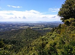
Although some people chose not to answer the census's question about religious affiliation, 57.5% had no religion, 30.7% were
121:
519:
1082:
640:
277:
1383:
1209:
410:
482:
The local state primary schools are Oratia School and
Henderson Valley School. The local state secondary schools are
1342:
1214:
694:
232:
1352:
1042:
996:
503:
487:
1264:
1259:
1047:
499:
483:
111:
1072:
931:
749:
426:
418:
396:
381:
377:
373:
244:
236:
878:
608:
1310:
1269:
1254:
1234:
1016:
936:
690:
612:
471:
450:
297:
289:
951:
804:
1347:
991:
686:
543:
511:
422:
400:
281:
265:
249:
828:
1249:
1219:
1144:
441:
Community facilities include a fire station, community hall, play centre, library, café and hotel.
228:
64:
1244:
1171:
164:
1302:
946:
776:
555:
414:
136:
30:
1292:
1181:
1139:
941:
664:
182:
1087:
1077:
658:"The Muddy Creeks Plan - a Local Area Plan for Parau, Laingholm, Woodlands Park and Waimā"
285:
273:
126:
392:
292:
resident
Frederick Judson. Afterwards, the name Waiatarua was applied to a larger area.
1164:
1129:
1124:
1109:
1104:
1062:
1057:
1052:
1021:
495:
1367:
1337:
1332:
1274:
1224:
1114:
1099:
1193:
1154:
1067:
388:
406:
The percentage of people born overseas was 25.4, compared with 27.1% nationally.
1149:
1119:
971:
917:
403:, and 2.5% other ethnicities. People may identify with more than one ethnicity.
1229:
956:
94:
81:
1001:
966:
723:
515:
463:
1037:
913:
60:
17:
1176:
467:
326:
869:"St Cuthbert's College – Making Girls Amazing – Auckland, New Zealand"
272:
that traces their ancestry to some of the earliest inhabitants of the
976:
961:
539:
276:. The name Waiatarua originally referred to the upper reaches of the
56:
868:
1011:
981:
280:
and
Nihotupu Stream, likely referencing the dual view of both the
639:. Waitakere City Council. 31 July 2009. p. 2. Archived from
986:
261:
240:
882:
771:
Vela, Pauline, ed. (1989). "From Four Horses to Four Wheels".
269:
603:
601:
321:
498:
in
Henderson (boys) or commute by train from Henderson to
802:. Statistics New Zealand. March 2020. Waiatarua (127600).
518:
village service schools in central
Auckland including
1320:
1285:
1202:
1030:
924:
689:; The Trustees of Te Kawerau Iwi Settlement Trust;
214:
206:
201:
193:
188:
178:
173:
152:
142:
132:
120:
110:
41:
851:"Secondary Schools | Catholic Diocese of Auckland"
380:, and an increase of 159 people (8.0%) since the
750:"Timber Mill, Nihotupu Stream, Waitākere Ranges"
894:
818:aucklandcouncil.govt.nz Retrieved 26 May 2023
794:
792:
775:. Glen Eden Borough Council. pp. 80–81.
634:"Waiatarua Local Area Plan Background Report"
8:
800:"Statistical area 1 dataset for 2018 Census"
376:, an increase of 72 people (3.5%) since the
312:
773:In Those Days: An Oral History of Glen Eden
718:
716:
714:
514:(boys). School buses departing from nearby
462:area. The nearest centres to Waiatarua are
901:
887:
879:
311:
227:is a small settlement near the top of the
38:
29:For the wetlands in Central Auckland, see
695:"Deed of Settlement Schedule: Documents"
1374:Populated places in the Auckland Region
831:. Regionalparks.aucklandcouncil.govt.nz
567:
200:
187:
172:
151:
109:
74:
70:
47:
1160:Te Rau-o-te-Huia / Mount Donald McLean
609:"Population estimate tables - NZ.Stat"
575:
573:
571:
300:to stay at the Waiatarua guest house.
1240:Te Uru Waitākere Contemporary Gallery
213:
205:
192:
177:
141:
131:
119:
7:
1135:Te Unuhanga-a-Rangitoto / Mercer Bay
805:2018 Census place summary: Waiatarua
243:and runs east until the junction of
197:11.37 km (4.39 sq mi)
528:Diocesan School for Girls, Auckland
490:. Catholic students usually attend
260:The area is within the traditional
239:, West Coast Road and Piha Road to
1187:Te Toka-Tapu-a-Kupe / Ninepin Rock
752:. Auckland Council Libraries. 1895
179: • Territorial Authority
25:
1379:Waitākere Ranges Local Board Area
910:Waitākere Ranges Local Board Area
1311:Waitakere City Council (defunct)
387:Ethnicities were 88.4% European/
49:
524:St Cuthbert's College, Auckland
1250:Waitākere Ranges Regional Park
730:. Land Information New Zealand
429:and 2.1% had other religions.
36:Place in Auckland, New Zealand
1:
1298:Waitākere Ranges Local Board
147:Waitākere Ranges Local Board
1210:Glen Eden Playhouse Theatre
520:Epsom Girls' Grammar School
235:, close to the junction of
1405:
1389:West Auckland, New Zealand
1343:Piha Surf Life Saving Club
1215:Goldie Bush Scenic Reserve
1203:Facilities and attractions
28:
997:Te Henga / Bethells Beach
816:Waiatarua Local Area Plan
534:Radio and television mast
365:
339:—
75:
71:
48:
1265:Upper Nihotupu Reservoir
1260:Lower Nihotupu Reservoir
1048:French Bay / Otitori Bay
829:"Arataki Visitor Centre"
581:"ArcGIS Web Application"
484:Kelston Boys High School
585:statsnz.maps.arcgis.com
415:Māori religious beliefs
374:2018 New Zealand census
218:210/km (540/sq mi)
1255:Arataki Visitor Centre
613:Statistics New Zealand
494:in Henderson (girls),
488:Kelston Girls' College
451:Arataki Visitor Centre
728:New Zealand Gazetteer
313:Historical population
1348:Project Twin Streams
857:on 15 November 2016.
693:(12 December 2013).
492:St Dominic's College
437:Community facilities
215: • Density
1270:Waitākere Reservoir
1220:Hoani Waititi Marae
1031:Geographic features
314:
91: /
1245:Waikumete Cemetery
1093:Little Muddy Creek
667:. 13 February 2014
508:St Peter's College
207: • Total
194: • Total
95:36.933°S 174.583°E
1361:
1360:
687:Te Kawerau ā Maki
556:New Zealand masts
370:
369:
266:Te Kawerau ā Maki
222:
221:
31:Waiatarua Reserve
16:(Redirected from
1396:
1384:Waitākere Ranges
1293:Auckland Council
1182:Paratutae Island
1145:Waitākere Ranges
1140:Waikumete Stream
942:Henderson Valley
925:Populated places
903:
896:
889:
880:
873:
872:
865:
859:
858:
853:. Archived from
847:
841:
840:
838:
836:
825:
819:
813:
807:
803:
796:
787:
786:
768:
762:
761:
759:
757:
746:
740:
739:
737:
735:
720:
709:
708:
706:
704:
699:
683:
677:
676:
674:
672:
665:Auckland Council
662:
654:
648:
647:
645:
638:
630:
624:
623:
621:
619:
605:
596:
595:
593:
591:
577:
328:
323:
315:
286:Manukau Harbours
229:Waitākere Ranges
183:Auckland Council
106:
105:
103:
102:
101:
100:-36.933; 174.583
96:
92:
89:
88:
87:
84:
65:Waitākere Ranges
59:looking towards
53:
39:
21:
1404:
1403:
1399:
1398:
1397:
1395:
1394:
1393:
1364:
1363:
1362:
1357:
1328:Ark in the Park
1316:
1281:
1198:
1172:Waitākere River
1088:Kakamatua Inlet
1083:Big Muddy Creek
1078:Manukau Harbour
1026:
920:
907:
877:
876:
867:
866:
862:
849:
848:
844:
834:
832:
827:
826:
822:
814:
810:
798:
797:
790:
783:
770:
769:
765:
755:
753:
748:
747:
743:
733:
731:
722:
721:
712:
702:
700:
697:
685:
684:
680:
670:
668:
660:
656:
655:
651:
646:on 15 May 2010.
643:
636:
632:
631:
627:
617:
615:
607:
606:
599:
589:
587:
579:
578:
569:
564:
552:
536:
480:
459:
447:
439:
397:Pacific peoples
306:
278:Big Muddy Creek
274:Auckland Region
258:
169:
165:Tāmaki Makaurau
99:
97:
93:
90:
85:
82:
80:
78:
77:
67:
44:
37:
34:
23:
22:
15:
12:
11:
5:
1402:
1400:
1392:
1391:
1386:
1381:
1376:
1366:
1365:
1359:
1358:
1356:
1355:
1350:
1345:
1340:
1335:
1330:
1324:
1322:
1318:
1317:
1315:
1314:
1307:
1306:
1305:
1303:Waitākere Ward
1300:
1289:
1287:
1283:
1282:
1280:
1279:
1278:
1277:
1272:
1267:
1262:
1257:
1247:
1242:
1237:
1232:
1227:
1222:
1217:
1212:
1206:
1204:
1200:
1199:
1197:
1196:
1191:
1190:
1189:
1184:
1174:
1169:
1168:
1167:
1165:Te Toiokawharu
1162:
1157:
1152:
1142:
1137:
1132:
1130:Taitomo Island
1127:
1125:Swanson Stream
1122:
1117:
1112:
1110:Opanuku Stream
1107:
1102:
1097:
1096:
1095:
1090:
1085:
1075:
1070:
1065:
1063:Lake Kawaupaka
1060:
1058:Kitekite Falls
1055:
1053:Karekare Falls
1050:
1045:
1040:
1034:
1032:
1028:
1027:
1025:
1024:
1022:Woodlands Park
1019:
1014:
1009:
1004:
999:
994:
989:
984:
979:
974:
969:
964:
959:
954:
949:
944:
939:
934:
928:
926:
922:
921:
908:
906:
905:
898:
891:
883:
875:
874:
860:
842:
820:
808:
788:
781:
763:
741:
710:
678:
649:
625:
597:
566:
565:
563:
560:
559:
558:
551:
548:
535:
532:
500:Marist College
496:Liston College
479:
476:
458:
455:
446:
443:
438:
435:
368:
367:
363:
362:
359:
356:
352:
351:
348:
345:
341:
340:
337:
334:
330:
329:
324:
319:
305:
302:
257:
254:
220:
219:
216:
212:
211:
208:
204:
203:
199:
198:
195:
191:
190:
186:
185:
180:
176:
175:
171:
170:
168:
167:
162:
156:
154:
150:
149:
144:
140:
139:
137:Waitākere ward
134:
130:
129:
124:
118:
117:
114:
108:
107:
73:
72:
69:
68:
55:Waiatarua and
54:
46:
45:
42:
35:
24:
14:
13:
10:
9:
6:
4:
3:
2:
1401:
1390:
1387:
1385:
1382:
1380:
1377:
1375:
1372:
1371:
1369:
1354:
1351:
1349:
1346:
1344:
1341:
1339:
1338:Oratia United
1336:
1334:
1333:Glenora Bears
1331:
1329:
1326:
1325:
1323:
1321:Organisations
1319:
1313:
1312:
1308:
1304:
1301:
1299:
1296:
1295:
1294:
1291:
1290:
1288:
1284:
1276:
1275:Whatipu Lodge
1273:
1271:
1268:
1266:
1263:
1261:
1258:
1256:
1253:
1252:
1251:
1248:
1246:
1243:
1241:
1238:
1236:
1233:
1231:
1228:
1226:
1225:Lopdell House
1223:
1221:
1218:
1216:
1213:
1211:
1208:
1207:
1205:
1201:
1195:
1192:
1188:
1185:
1183:
1180:
1179:
1178:
1175:
1173:
1170:
1166:
1163:
1161:
1158:
1156:
1153:
1151:
1148:
1147:
1146:
1143:
1141:
1138:
1136:
1133:
1131:
1128:
1126:
1123:
1121:
1118:
1116:
1115:Oratia Stream
1113:
1111:
1108:
1106:
1103:
1101:
1100:Mokoroa Falls
1098:
1094:
1091:
1089:
1086:
1084:
1081:
1080:
1079:
1076:
1074:
1071:
1069:
1066:
1064:
1061:
1059:
1056:
1054:
1051:
1049:
1046:
1044:
1041:
1039:
1036:
1035:
1033:
1029:
1023:
1020:
1018:
1015:
1013:
1010:
1008:
1005:
1003:
1000:
998:
995:
993:
990:
988:
985:
983:
980:
978:
975:
973:
970:
968:
965:
963:
960:
958:
955:
953:
950:
948:
945:
943:
940:
938:
935:
933:
930:
929:
927:
923:
919:
915:
911:
904:
899:
897:
892:
890:
885:
884:
881:
870:
864:
861:
856:
852:
846:
843:
830:
824:
821:
817:
812:
809:
806:
801:
795:
793:
789:
784:
782:0-473-00862-9
778:
774:
767:
764:
751:
745:
742:
729:
725:
719:
717:
715:
711:
696:
692:
688:
682:
679:
666:
659:
653:
650:
642:
635:
629:
626:
614:
610:
604:
602:
598:
586:
582:
576:
574:
572:
568:
561:
557:
554:
553:
549:
547:
545:
541:
533:
531:
529:
525:
521:
517:
513:
509:
505:
501:
497:
493:
489:
485:
477:
475:
473:
469:
465:
456:
454:
452:
444:
442:
436:
434:
430:
428:
424:
420:
416:
412:
407:
404:
402:
398:
394:
390:
385:
383:
379:
375:
364:
360:
357:
354:
353:
349:
346:
343:
342:
338:
335:
332:
331:
325:
320:
317:
316:
310:
303:
301:
299:
293:
291:
287:
283:
279:
275:
271:
267:
263:
255:
253:
251:
246:
242:
238:
234:
233:West Auckland
230:
226:
217:
209:
196:
184:
181:
166:
163:
161:
158:
157:
155:
148:
145:
138:
135:
128:
125:
123:
115:
113:
104:
76:Coordinates:
66:
62:
58:
52:
40:
32:
27:
19:
1309:
1235:Scenic Drive
1194:Whites Beach
1155:Ruaotuwhenua
1068:Lake Wainamu
1006:
863:
855:the original
845:
833:. Retrieved
823:
811:
772:
766:
754:. Retrieved
744:
732:. Retrieved
727:
701:. Retrieved
681:
669:. Retrieved
652:
641:the original
628:
616:. Retrieved
588:. Retrieved
584:
537:
504:Mount Albert
481:
460:
448:
440:
431:
425:, 0.8% were
421:, 1.1% were
417:, 1.1% were
408:
405:
386:
371:
307:
304:Demographics
294:
290:Scenic Drive
259:
245:Scenic Drive
237:Scenic Drive
224:
223:
26:
1353:Studio West
1150:Pukematekeo
1120:Piha Stream
1105:O'Neill Bay
1043:Fairy Falls
972:Little Huia
918:New Zealand
724:"Waiatarua"
506:(girls) or
449:The nearby
413:, 0.3% had
382:2006 census
378:2013 census
153:Electorates
143:Local board
116:New Zealand
98: /
63:, from the
1368:Categories
1286:Government
1230:Parrs Park
957:Kaurilands
932:Cornwallis
618:25 October
562:References
470:, and the
202:Population
174:Government
1073:Lion Rock
1017:Waitākere
1007:Waiatarua
1002:Titirangi
967:Laingholm
937:Glen Eden
691:The Crown
544:Sky Tower
516:Titirangi
478:Education
472:Henderson
466:village,
464:Titirangi
411:Christian
298:Glen Eden
282:Waitematā
250:Sky Tower
225:Waiatarua
43:Waiatarua
1038:Anawhata
952:Karekare
914:Auckland
756:18 April
734:27 April
703:26 April
590:28 March
550:See also
474:Valley.
457:Tramping
427:Buddhist
391:, 11.7%
366:Source:
160:New Lynn
127:Auckland
86:174°35′E
61:Auckland
18:Nihotupu
1177:Whatipu
992:Swanson
671:28 June
512:Grafton
468:Swanson
445:Tourism
399:, 6.7%
395:, 5.0%
327:±% p.a.
256:History
112:Country
83:36°56′S
977:Oratia
962:Konini
835:14 May
779:
540:Kordia
423:Muslim
389:Pākehā
361:+0.68%
350:+0.61%
122:Region
57:Oratia
1012:Waima
982:Parau
698:(PDF)
661:(PDF)
644:(PDF)
637:(PDF)
419:Hindu
401:Asian
393:Māori
358:2,148
347:2,076
336:1,989
268:, an
210:2,350
987:Piha
947:Huia
837:2015
777:ISBN
758:2024
736:2022
705:2022
673:2021
620:2023
592:2024
526:and
486:and
355:2018
344:2013
333:2006
322:Pop.
318:Year
284:and
262:rohe
241:Piha
189:Area
133:Ward
510:in
502:in
270:iwi
264:of
231:in
1370::
916:,
912:,
791:^
726:.
713:^
663:.
611:.
600:^
583:.
570:^
546:.
530:.
522:,
902:e
895:t
888:v
871:.
839:.
785:.
760:.
738:.
707:.
675:.
622:.
594:.
33:.
20:)
Text is available under the Creative Commons Attribution-ShareAlike License. Additional terms may apply.