93:
86:
644:
37:
85:
690:
643:
136:
680:
685:
285:
eastwards to the Pfeis Hut north of the Rumer Spitze. Below the
Hungerburg - Seegrube section of the Nordkette Cableway runs the
129:
650:
290:
632:
622:
609:
596:
586:
576:
563:
553:
540:
527:
517:
504:
491:
481:
471:
458:
448:
435:
425:
415:
402:
389:
376:
363:
333:
265:
239:
220:
534:
409:
396:
255:
225:
664:
383:
312:
603:
92:
616:
570:
511:
320:
247:
547:
700:
695:
113:
357:
327:
316:
370:
233:
55:
498:
300:
210:
293:
202:
674:
269:) on the Nordkette Cable Car, and runs via the Seegrubenspitze, the Kemacher and the
308:
229:
151:
138:
442:
274:
206:
194:
341:
and which is separated from the
Nordkette to the northeast and east by the
465:
326:
In the southwest, there is a small massif in front of the
Nordkette, the
304:
282:
251:
36:
653:
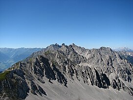
Panoramic view from
Innsbruck (Emile Béthouart Steg) of the North Chain
353:
The most important summits of the
Nordkette from west to east are the:
198:
117:
62:
277:
and the Frau Hitt Saddle in the west. In addition, the Goethe Way (
307:
bases for multi-day tours taking in numerous summits: the
41:
The North Chain seen from the
Mandlspitze, looking west
193:), is a range of mountains just north of the city of
209:. To the west it is linked by the Erl Saddle to the
289:, one of the most challenging routes in Europe for
128:
73:
61:
51:
46:
21:
8:
201:. It is the southernmost of the four great
18:
691:Mountain ranges of Tyrol (federal state)
281:) runs from Hafelekar Station along the
258:. The latter starts in the east, near
68:2,637 m above sea level (AA)
7:
228:. To the south it is bounded by the
105:Inntalkette / Nordkette im Karwendel
28:Inntalkette / Nordkette im Karwendel
303:in the area of the Nordkette offer
250:, which offers easy access to the
14:
323:(in the Gleirsch-Halltal Range).
102:also North Chain / Northern Range
25:also North Chain / Northern Range
642:
91:
84:
35:
667:– Website about the North Chain
246:The Nordkette is served by the
1:
330:, which reaches a height of
243:) in the west of the range.
232:. Its highest summit is the
173:, also variously called the
681:Mountain ranges of the Alps
717:
686:Two-thousanders of Austria
665:www.nordkette-austria.net
78:
34:
455:Westliche Sattelspitze (
535:Gleirschtaler Brandjoch
410:Vordere Brandjochspitze
397:Hintere Brandjochspitze
213:, to the east via the
256:Innsbruck Klettersteig
226:Gleirsch-Halltal Range
287:Nordkette Singletrail
152:47.30000°N 11.35000°E
560:Thaurer Jochspitze (
313:Neue Magdeburger Hut
248:Nordkette Cable Car
148: /
16:Mountain in Austria
604:Thaurer Zunterkopf
157:47.30000; 11.35000
47:Highest point
617:Haller Zunterkopf
593:Wildangerspitze (
488:Seegrubenspitze (
349:Important summits
343:Kranebitter Klamm
167:
166:
130:Range coordinates
107:
30:
708:
646:
635:
625:
612:
599:
589:
579:
566:
556:
543:
530:
520:
507:
494:
484:
478:Kumpfkarspitze (
474:
461:
451:
438:
432:Brandjochkreuz (
428:
418:
405:
392:
379:
371:Kleiner Solstein
366:
336:
301:Alpine Club huts
268:
242:
234:Kleiner Solstein
223:
187:Inn Valley Chain
183:Inn Valley Range
163:
162:
160:
159:
158:
153:
149:
146:
145:
144:
141:
101:
95:
94:
88:
69:
56:Kleiner Solstein
39:
24:
19:
716:
715:
711:
710:
709:
707:
706:
705:
671:
670:
661:
656:
655:
654:
652:
647:
630:
620:
607:
594:
584:
574:
561:
551:
538:
525:
515:
502:
499:Hafelekarspitze
489:
479:
469:
456:
446:
433:
423:
413:
400:
387:
374:
361:
358:Großer Solstein
351:
331:
294:mountain bikers
263:
237:
218:
211:Erlspitze Group
203:mountain chains
156:
154:
150:
147:
142:
139:
137:
135:
134:
124:
123:
122:
121:
120:
111:
110:
109:
108:
103:
100:
96:
67:
42:
26:
23:
17:
12:
11:
5:
714:
712:
704:
703:
698:
693:
688:
683:
673:
672:
669:
668:
660:
659:External links
657:
649:
648:
641:
640:
639:
638:
637:
629:Hochmahdkopf (
627:
614:
601:
591:
583:Lattenspitze (
581:
571:Pfeiser Spitze
568:
558:
545:
532:
522:
512:Gleirschspitze
509:
496:
486:
476:
463:
453:
440:
430:
422:Hippenspitze (
420:
407:
394:
381:
368:
350:
347:
339:Kirchbergköpfl
321:Bettelwurf Hut
299:The following
179:Northern Range
165:
164:
132:
126:
125:
112:
98:
97:
90:
89:
83:
82:
81:
80:
79:
76:
75:
71:
70:
65:
59:
58:
53:
49:
48:
44:
43:
40:
32:
31:
15:
13:
10:
9:
6:
4:
3:
2:
713:
702:
699:
697:
694:
692:
689:
687:
684:
682:
679:
678:
676:
666:
663:
662:
658:
651:
645:
634:
628:
624:
618:
615:
611:
605:
602:
598:
592:
588:
582:
578:
572:
569:
565:
559:
555:
549:
546:
542:
536:
533:
529:
524:Mandlspitze (
523:
519:
513:
510:
506:
500:
497:
493:
487:
483:
477:
473:
467:
464:
460:
454:
450:
444:
441:
437:
431:
427:
421:
417:
411:
408:
404:
398:
395:
391:
385:
382:
378:
372:
369:
365:
359:
356:
355:
354:
348:
346:
344:
340:
335:
329:
324:
322:
318:
314:
310:
306:
302:
297:
295:
292:
288:
284:
280:
276:
272:
271:Langen Sattel
267:
261:
257:
253:
249:
244:
241:
235:
231:
227:
222:
216:
212:
208:
204:
200:
196:
192:
188:
184:
181:, rarely the
180:
176:
172:
161:
133:
131:
127:
119:
115:
106:
87:
77:
72:
66:
64:
60:
57:
54:
50:
45:
38:
33:
29:
20:
548:Rumer Spitze
352:
342:
338:
325:
309:Solsteinhaus
298:
286:
278:
270:
259:
245:
214:
190:
186:
182:
178:
174:
170:
168:
104:
27:
633:m (AA)
631:1,738
623:m (AA)
621:1,966
610:m (AA)
608:1,918
597:m (AA)
595:2,153
587:m (AA)
585:2,330
577:m (AA)
575:2,347
564:m (AA)
562:2,306
554:m (AA)
552:2,454
541:m (AA)
539:2,372
528:m (AA)
526:2,366
518:m (AA)
516:2,317
505:m (AA)
503:2,334
492:m (AA)
490:2,350
482:m (AA)
480:2,393
472:m (AA)
470:2,480
459:m (AA)
457:2,339
449:m (AA)
447:2,270
436:m (AA)
434:2,268
426:m (AA)
424:2,388
416:m (AA)
414:2,559
403:m (AA)
401:2,599
390:m (AA)
388:2,597
377:m (AA)
375:2,637
364:m (AA)
362:2,541
334:m (AA)
332:1,943
266:m (AA)
264:2,269
240:m (AA)
238:2,637
221:m (AA)
219:2,215
215:Stempeljoch
191:Inntalkette
175:North Chain
155: /
675:Categories
384:Hohe Warte
328:Hechenberg
230:Inn valley
143:11°21′00″E
140:47°18′00″N
701:Innsbruck
696:Karwendel
443:Frau Hitt
317:Pfeis Hut
279:Goetheweg
275:Frau Hitt
262:station (
260:Hafelekar
224:) to the
207:Karwendel
195:Innsbruck
171:Nordkette
99:Nordkette
74:Geography
63:Elevation
22:Nordkette
466:Kemacher
319:and the
305:climbers
291:freeride
254:and the
252:ski area
217:saddle (
337:at the
205:in the
199:Austria
118:Austria
315:, the
311:, the
283:arête
114:Tyrol
169:The
52:Peak
273:to
197:in
185:or
677::
345:.
296:.
177:,
116:,
636:)
626:)
619:(
613:)
606:(
600:)
590:)
580:)
573:(
567:)
557:)
550:(
544:)
537:(
531:)
521:)
514:(
508:)
501:(
495:)
485:)
475:)
468:(
462:)
452:)
445:(
439:)
429:)
419:)
412:(
406:)
399:(
393:)
386:(
380:)
373:(
367:)
360:(
236:(
189:(
Text is available under the Creative Commons Attribution-ShareAlike License. Additional terms may apply.