43:
558:
469:
529:
416:. There were 306 households, comprising 393 males and 411 females, giving a sex ratio of 0.96 males per female. The median age was 46.3 years (compared with 37.4 years nationally), with 132 people (16.4%) aged under 15 years, 138 (17.2%) aged 15 to 29, 429 (53.4%) aged 30 to 64, and 108 (13.4%) aged 65 or older.
545:. Another parkland, Greendale Reserve, was formerly two rundown paddocks but it has been the subject of local volunteer efforts to revitalise its environment and restore native plants. These efforts began in 1997 and have involved the students of Kenakena School. In 2006, the volunteer work was honoured by a
452:
Of those at least 15 years old, 147 (21.9%) people had a bachelor's or higher degree, and 114 (17.0%) people had no formal qualifications. The median income was $ 37,800, compared with $ 31,800 nationally. 168 people (25.0%) earned over $ 70,000 compared to 17.2% nationally. The employment status of
536:
As
Otaihanga is on the banks of the Waikanae River, it can be susceptible to flooding during storms and periods of high rainfall. Serious flooding in the first week of January 2005 damaged 18 houses and necessitated the evacuation to higher ground of a number of residents by boat. After the
540:
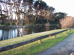
The main parkland in
Otaihanga is the Otaihanga Domain, on the banks of the Waikanae River. It is used for leisure activities and has no sporting facilities. It has family amenities and a footbridge across the river to
503:
used to take place, but has now largely ceased as residential developments have been built. Otaihanga has become primarily residential, and some small-scale commercial businesses operate. The Kāpiti Coast's main
42:
576:
lowered the speed limit of the highway in the area from 100 km/h to 80 km/h as an attempt to reduce accidents. A roundabout was installed in 2013 but the design of the roundabout has been criticised.
341:
Otaihanga statistical area covers 4.16 km (1.61 sq mi). It had an estimated population of 900 as of June 2023, with a population density of 216.35 people per km.
561:
The North Island Main Trunk
Railway, looking south from the Otaihanga Road level crossing. On the right is the location of a former halt; on the left is Southward Car Museum.
1497:
970:
537:
flooding, the raising of three houses was prioritised and long term options such as upgrading flood stopbanks and extracting gravel from the riverbed were investigated.
404:
Before the 2023 census, Otaihanga had a larger boundary, covering 4.47 km (1.73 sq mi). Using that boundary, Otaihanga had a population of 804 at the
520:, minutes away in Paraparaumu. One of the primary schools, Kenakena School, has been involved in works to improve Otaihanga's environment at Greendale Reserve.
722:
856:
869:
585:
1327:
963:
756:
118:
1359:
1333:
1287:
64:
1425:
192:
1461:
1277:
883:
923:
326:
1502:
956:
637:
1415:
453:
those at least 15 was that 366 (54.5%) people were employed full-time, 96 (14.3%) were part-time, and 15 (2.2%) were unemployed.
182:
596:
589:
441:
Although some people chose not to answer the census's question about religious affiliation, 63.8% had no religion, 28.0% were
1077:
213:
154:
1272:
695:
1344:
1339:
608:
565:
485:
442:
719:
1349:
1307:
1234:
1184:
940:
802:
1399:
1312:
600:
1389:
1046:
739:
612:
284:
272:
96:
1420:
979:
200:
123:
1476:
1379:
1292:
581:
557:
481:
446:
428:
413:
409:
405:
146:
948:
662:
568:
runs through eastern
Otaihanga. The intersection of the highway and Otaihanga Road is a notorious traffic
1394:
1369:
807:
666:
516:
There are no educational institutions in
Otaihanga, but there are primary schools and a secondary school,
106:
996:
761:
231:
1021:
1374:
1317:
1302:
1297:
1214:
477:
432:
163:
1466:
1441:
1364:
1229:
1204:
573:
517:
489:
47:
The
Waikanae River as viewed from its southern bank in Otaihanga. Across the river is the town of
588:. The two ends of the line met at Otaihanga and the last spike was driven at a public ceremony by
1471:
773:
569:
1451:
1446:
1256:
1251:
1224:
1209:
1108:
1067:
983:
919:
843:
546:
319:
226:
159:
111:
1456:
1354:
1282:
1174:
1169:
1113:
1072:
476:
Located in
Otaihanga is one of the Kāpiti Coast's most significant tourist attractions, the
468:
1246:
726:
592:
218:
1322:
424:
299:
1241:
1199:
1194:
1189:
1031:
1026:
311:
205:
48:
1491:
1384:
1219:
1179:
1087:
1082:
1041:
492:
and contains other attractions such as heritage planes, and it has a large theatre.
303:
420:
438:
The percentage of people born overseas was 18.3, compared with 27.1% nationally.
1103:
1000:
987:
604:
500:
457:
435:, and 2.6% other ethnicities. People may identify with more than one ethnicity.
307:
528:
1139:
315:
687:
595:. The railway opened on 3 November 1886 and passed into the ownership of the
79:
66:
1149:
1144:
1134:
542:
505:
1051:
1036:
358:
830:
789:
556:
549:, with the school receiving the 2006 Young Conservationist Award.
527:
488:
to the east. It has one of the largest collections of cars in the
467:
952:
742:. New Zealand Ministry for Culture and Heritage. 6 August 2019.
314:
and is roughly 55 km north of New
Zealand's capital city,
884:"Minor flaws found in State Highway 1's Otaihanga roundabout"
353:
759:. Statistics New Zealand. March 2020. Otaihanga (237400).
472:
The entrance to
Southward Car Museum from Otaihanga Road.
456:
The demographics for
Otaihanga are also incorporated in
916:
The Railways of New Zealand: A Journey through History
1434:
1408:
1265:
1162:
1127:
1096:
1060:
1014:
1007:
599:on 8 December 1908. There was a passenger halt at
283:
271:
263:
255:
250:
242:
237:
224:
211:
198:
188:
178:
173:
145:
137:
129:
117:
105:
95:
26:
859:, posted 1 August 2006, accessed 28 November 2007.
833:, posted 8 March 2005, accessed 28 November 2007.
532:The Makora Road entrance to the Otaihanga Domain.
857:"Media Release: Speed Limit Change At Otaihanga"
855:Transit New Zealand Wellington Regional Office,
412:, and an increase of 54 people (7.2%) since the
329:gives a translation of "place of Taihanga " for
896:
964:
751:
749:
8:
914:Churchman, Geoffrey B; Hurst, Tony (2001) .
831:"House Raising in Otaihanga Brought Forward"
757:"Statistical area 1 dataset for 2018 Census"
408:, an increase of 69 people (9.4%) since the
344:
16:Settlement in Wellington Region, New Zealand
918:(Second ed.). Transpress New Zealand.
784:
782:
1011:
971:
957:
949:
343:
23:
1498:Populated places in the Wellington Region
714:
712:
944:from the Cyclopedia of New Zealand, 1897
870:"Work starts on Otaihanga intersection"
624:
586:Wellington and Manawatu Railway Company
270:
249:
236:
172:
144:
94:
59:
55:
39:
803:"18 homes flooded north of Wellington"
663:"Population estimate tables - NZ.Stat"
632:
630:
628:
21:Town in Wellington Region, New Zealand
829:Greater Wellington Regional Council,
788:Greater Wellington Regional Council,
282:
262:
254:
241:
223:
210:
197:
187:
177:
136:
128:
116:
104:
7:
762:2018 Census place summary: Otaihanga
584:railway, on a section built by the
246:4.16 km (1.61 sq mi)
193:Greater Wellington Regional Council
1462:Paekakariki Station Precinct Trust
1278:Charles Fleming Retirement Village
322:for "the place made by the tide".
179: • Territorial Authority
14:
327:Ministry for Culture and Heritage
419:Ethnicities were 94.8% European/
41:
886:. Stuff/Fairfax. 31 March 2015.
842:Kāpiti Coast District Council,
772:Kāpiti Coast District Council,
718:Kāpiti Coast District Council,
597:New Zealand Railways Department
872:. Stuff/Fairfax. 23 July 2013.
688:"Place name detail: Otaihanga"
480:on Otaihanga Road between the
449:and 2.2% had other religions.
1:
547:Conservation Week Merit Award
189: • Regional council
183:Kāpiti Coast District Council
1273:Battle Hill Farm Forest Park
846:, accessed 28 November 2007.
792:, accessed 28 November 2007.
776:, accessed 28 November 2007.
729:, accessed 28 November 2007.
696:New Zealand Geographic Board
1426:Wellington Regional Council
1345:Paekakariki railway station
1340:Paraparaumu railway station
1519:
1350:Paekakariki Station Museum
1266:Facilities and attractions
897:Churchman & Hurst 2001
607:commuter services stop at
1400:Wellington Tramway Museum
1313:Otaihanga railway station
994:
397:
371:—
310:on the south bank of the
60:
56:
40:
33:
1390:Waikanae railway station
1288:Hadfield railway station
1061:Paekākāriki-Raumati Ward
740:"1000 Māori place names"
638:"ArcGIS Web Application"
484:railway to the west and
458:Paraparaumu#Demographics
1380:Te Horo railway station
1308:Ngā Manu Nature Reserve
1293:Hautere railway station
1185:Maungakōtukutuku Stream
642:statsnz.maps.arcgis.com
582:North Island Main Trunk
482:North Island Main Trunk
406:2018 New Zealand census
306:. It is just north of
267:220/km (560/sq mi)
1395:Wainui railway station
1370:Raumati Marine Gardens
808:The New Zealand Herald
790:"Friends of Greendale"
667:Statistics New Zealand
562:
533:
473:
1503:Kāpiti Coast District
1328:Ōtaki railway station
980:Kāpiti Coast District
692:New Zealand Gazetteer
560:
531:
471:
345:Historical population
232:Debbie Ngarewa-Packer
141:Paraparaumu Community
124:Kāpiti Coast District
119:Territorial authority
1477:Te Wānanga o Raukawa
1375:Southward Car Museum
1360:Queen Elizabeth Park
1298:Kapiti Coast Airport
1215:South Taranaki Bight
844:"Parks and Reserves"
611:and the terminus at
580:Otaihanga is on the
572:and in August 2006,
478:Southward Car Museum
264: • Density
80:40.8815°S 175.0137°E
1467:Paraparaumu College
1442:Kapiti Coast United
1334:Our Lady of Lourdes
1205:Rauoterangi Channel
1163:Geographic features
574:Transit New Zealand
518:Paraparaumu College
490:Southern Hemisphere
346:
76: /
1472:Steam Incorporated
774:"Waste Management"
725:2008-10-14 at the
563:
534:
474:
256: • Total
243: • Total
201:Kāpiti Coast Mayor
85:-40.8815; 175.0137
1485:
1484:
1452:Kapiti Fine Foods
1318:Ōtaki Health Camp
1303:Kāpiti Expressway
1257:Wharemauku Stream
1252:Waitewaewae River
1225:Southern Crossing
1210:Reikorangi Stream
1158:
1157:
1109:Paraparaumu Beach
984:Kapiti Urban Area
508:is in Otaihanga.
402:
401:
302:of New Zealand's
293:
292:
227:Te Tai Hauāuru MP
112:Wellington Region
1510:
1416:District Council
1365:Rangiātea Church
1355:Pharazyn Reserve
1283:Escarpment Track
1175:Akatarawa Valley
1170:Akatarawa Saddle
1114:Maungakotukutuku
1097:Paraparaumu Ward
1078:Moonshine Valley
1073:Mackays Crossing
1012:
1008:Populated places
973:
966:
959:
950:
929:
900:
894:
888:
887:
880:
874:
873:
866:
860:
853:
847:
840:
834:
827:
821:
820:
818:
816:
811:. 6 January 2005
799:
793:
786:
777:
770:
764:
760:
753:
744:
743:
736:
730:
716:
707:
706:
704:
702:
684:
678:
677:
675:
673:
659:
653:
652:
650:
648:
634:
360:
355:
347:
325:The New Zealand
133:Paraparaumu Ward
91:
90:
88:
87:
86:
81:
77:
74:
73:
72:
69:
45:
24:
1518:
1517:
1513:
1512:
1511:
1509:
1508:
1507:
1488:
1487:
1486:
1481:
1430:
1404:
1261:
1247:Waiotauru River
1154:
1123:
1092:
1056:
1003:
990:
977:
937:
932:
926:
913:
909:
907:Further reading
904:
903:
895:
891:
882:
881:
877:
868:
867:
863:
854:
850:
841:
837:
828:
824:
814:
812:
801:
800:
796:
787:
780:
771:
767:
755:
754:
747:
738:
737:
733:
727:Wayback Machine
717:
710:
700:
698:
686:
685:
681:
671:
669:
661:
660:
656:
646:
644:
636:
635:
626:
621:
593:William Jervois
566:State Highway 1
555:
526:
514:
498:
486:State Highway 1
466:
339:
318:. Its name is
279:
219:Barbara Edmonds
169:
84:
82:
78:
75:
70:
67:
65:
63:
62:
52:
36:
29:
22:
17:
12:
11:
5:
1516:
1514:
1506:
1505:
1500:
1490:
1489:
1483:
1482:
1480:
1479:
1474:
1469:
1464:
1459:
1454:
1449:
1447:Kāpiti College
1444:
1438:
1436:
1432:
1431:
1429:
1428:
1423:
1418:
1412:
1410:
1406:
1405:
1403:
1402:
1397:
1392:
1387:
1382:
1377:
1372:
1367:
1362:
1357:
1352:
1347:
1342:
1337:
1330:
1325:
1320:
1315:
1310:
1305:
1300:
1295:
1290:
1285:
1280:
1275:
1269:
1267:
1263:
1262:
1260:
1259:
1254:
1249:
1244:
1242:Waikanae River
1239:
1238:
1237:
1232:
1227:
1217:
1212:
1207:
1202:
1200:Rangiora River
1197:
1192:
1190:Ngatiawa River
1187:
1182:
1177:
1172:
1166:
1164:
1160:
1159:
1156:
1155:
1153:
1152:
1147:
1145:Waikanae Beach
1142:
1137:
1131:
1129:
1125:
1124:
1122:
1121:
1116:
1111:
1106:
1100:
1098:
1094:
1093:
1091:
1090:
1085:
1080:
1075:
1070:
1064:
1062:
1058:
1057:
1055:
1054:
1049:
1044:
1039:
1034:
1029:
1024:
1018:
1016:
1009:
1005:
1004:
995:
992:
991:
978:
976:
975:
968:
961:
953:
947:
946:
936:
935:External links
933:
931:
930:
924:
910:
908:
905:
902:
901:
899:, p. 165.
889:
875:
861:
848:
835:
822:
794:
778:
765:
745:
731:
708:
679:
654:
623:
622:
620:
617:
554:
551:
525:
522:
513:
510:
497:
494:
465:
462:
400:
399:
395:
394:
391:
388:
384:
383:
380:
377:
373:
372:
369:
366:
362:
361:
356:
351:
338:
335:
312:Waikanae River
291:
290:
287:
281:
280:
277:
275:
269:
268:
265:
261:
260:
257:
253:
252:
248:
247:
244:
240:
239:
235:
234:
229:
222:
221:
216:
209:
208:
206:Janet Holborow
203:
196:
195:
190:
186:
185:
180:
176:
175:
171:
170:
168:
167:
160:Te Tai Hauāuru
157:
151:
149:
143:
142:
139:
135:
134:
131:
127:
126:
121:
115:
114:
109:
103:
102:
99:
93:
92:
58:
57:
54:
53:
49:Waikanae Beach
46:
38:
37:
34:
31:
30:
27:
20:
15:
13:
10:
9:
6:
4:
3:
2:
1515:
1504:
1501:
1499:
1496:
1495:
1493:
1478:
1475:
1473:
1470:
1468:
1465:
1463:
1460:
1458:
1457:Ōtaki College
1455:
1453:
1450:
1448:
1445:
1443:
1440:
1439:
1437:
1435:Organisations
1433:
1427:
1424:
1422:
1419:
1417:
1414:
1413:
1411:
1407:
1401:
1398:
1396:
1393:
1391:
1388:
1386:
1385:Waikanae Park
1383:
1381:
1378:
1376:
1373:
1371:
1368:
1366:
1363:
1361:
1358:
1356:
1353:
1351:
1348:
1346:
1343:
1341:
1338:
1336:
1335:
1331:
1329:
1326:
1324:
1321:
1319:
1316:
1314:
1311:
1309:
1306:
1304:
1301:
1299:
1296:
1294:
1291:
1289:
1286:
1284:
1281:
1279:
1276:
1274:
1271:
1270:
1268:
1264:
1258:
1255:
1253:
1250:
1248:
1245:
1243:
1240:
1236:
1233:
1231:
1228:
1226:
1223:
1222:
1221:
1220:Tararua Range
1218:
1216:
1213:
1211:
1208:
1206:
1203:
1201:
1198:
1196:
1193:
1191:
1188:
1186:
1183:
1181:
1180:Kapiti Island
1178:
1176:
1173:
1171:
1168:
1167:
1165:
1161:
1151:
1148:
1146:
1143:
1141:
1138:
1136:
1133:
1132:
1130:
1128:Waikanae Ward
1126:
1120:
1117:
1115:
1112:
1110:
1107:
1105:
1102:
1101:
1099:
1095:
1089:
1088:Raumati South
1086:
1084:
1083:Raumati Beach
1081:
1079:
1076:
1074:
1071:
1069:
1066:
1065:
1063:
1059:
1053:
1050:
1048:
1045:
1043:
1042:Te Horo Beach
1040:
1038:
1035:
1033:
1030:
1028:
1025:
1023:
1020:
1019:
1017:
1013:
1010:
1006:
1002:
998:
993:
989:
985:
981:
974:
969:
967:
962:
960:
955:
954:
951:
945:
943:
939:
938:
934:
927:
925:0-908876-20-3
921:
917:
912:
911:
906:
898:
893:
890:
885:
879:
876:
871:
865:
862:
858:
852:
849:
845:
839:
836:
832:
826:
823:
810:
809:
804:
798:
795:
791:
785:
783:
779:
775:
769:
766:
763:
758:
752:
750:
746:
741:
735:
732:
728:
724:
721:
715:
713:
709:
697:
693:
689:
683:
680:
668:
664:
658:
655:
643:
639:
633:
631:
629:
625:
618:
616:
614:
610:
606:
602:
598:
594:
591:
587:
583:
578:
575:
571:
567:
559:
552:
550:
548:
544:
538:
530:
523:
521:
519:
511:
509:
507:
502:
495:
493:
491:
487:
483:
479:
470:
463:
461:
459:
454:
450:
448:
444:
439:
436:
434:
430:
426:
422:
417:
415:
411:
407:
396:
392:
389:
386:
385:
381:
378:
375:
374:
370:
367:
364:
363:
357:
352:
349:
348:
342:
336:
334:
332:
328:
323:
321:
317:
313:
309:
305:
301:
297:
288:
286:
276:
274:
266:
258:
245:
233:
230:
228:
225: •
220:
217:
215:
212: •
207:
204:
202:
199: •
194:
191:
184:
181:
165:
161:
158:
156:
153:
152:
150:
148:
140:
132:
125:
122:
120:
113:
110:
108:
100:
98:
89:
61:Coordinates:
50:
44:
32:
25:
19:
1332:
1323:Ōtaki Museum
1235:Mount Hector
1118:
1047:Forest Lakes
941:
915:
892:
878:
864:
851:
838:
825:
813:. Retrieved
806:
797:
768:
734:
699:. Retrieved
691:
682:
670:. Retrieved
657:
645:. Retrieved
641:
603:until 1902.
579:
564:
539:
535:
515:
499:
475:
455:
451:
445:, 0.4% were
440:
437:
418:
403:
340:
337:Demographics
330:
324:
304:North Island
300:Kāpiti Coast
295:
294:
18:
1230:Forest Park
1195:Ōtaki River
1104:Paraparaumu
1068:Paekākāriki
1032:Ōtaki Forks
1027:Ōtaki Beach
1001:Paraparaumu
988:New Zealand
609:Paraparaumu
605:Kapiti Line
524:Environment
506:rubbish tip
501:Agriculture
464:Attractions
414:2006 census
410:2013 census
308:Paraparaumu
273:Postcode(s)
147:Electorates
101:New Zealand
83: /
71:175°00′49″E
1492:Categories
1409:Government
1140:Reikorangi
1015:Ōtaki Ward
815:1 November
672:25 October
619:References
570:black spot
316:Wellington
298:is on the
251:Population
174:Government
68:40°52′53″S
1150:Peka Peka
1119:Otaihanga
942:Otaihanga
720:"Tourism"
601:Otaihanga
553:Transport
512:Education
443:Christian
331:Ōtaihanga
296:Otaihanga
285:Area code
138:Community
28:Otaihanga
1135:Waikanae
723:Archived
647:29 March
613:Waikanae
590:Governor
543:Waikanae
447:Buddhist
429:Pasifika
423:, 12.7%
398:Source:
1052:Waitohu
1037:Te Horo
496:Economy
431:, 0.7%
427:, 1.5%
359:±% p.a.
214:Mana MP
97:Country
922:
701:21 May
421:Pākehā
393:+1.81%
382:−0.29%
107:Region
1421:Mayor
1022:Ōtaki
433:Asian
425:Māori
320:Māori
164:Māori
997:Seat
982:and
920:ISBN
817:2011
703:2021
674:2023
649:2024
387:2018
376:2013
365:2006
354:Pop.
350:Year
278:5036
238:Area
155:Mana
130:Ward
35:Town
390:804
379:735
368:750
259:900
1494::
999::
986:,
805:.
781:^
748:^
711:^
694:.
690:.
665:.
640:.
627:^
615:.
460:.
333:.
289:04
972:e
965:t
958:v
928:.
819:.
705:.
676:.
651:.
166:)
162:(
51:.
Text is available under the Creative Commons Attribution-ShareAlike License. Additional terms may apply.